
Einhausen (Thuringia)
| coat of arms | Germany map | |
|---|---|---|
.svg)
|
Coordinates: 50 ° 32 ' N , 10 ° 28' E |
|
| Basic data | ||
| State : | Thuringia | |
| County : | Schmalkalden-Meiningen | |
| Management Community : | Dolmar salt bridge | |
| Height : | 305 m above sea level NHN | |
| Area : | 5.33 km 2 | |
| Residents: | 400 (Dec. 31, 2019) | |
| Population density : | 75 inhabitants per km 2 | |
| Postal code : | 98617 | |
| Area code : | 036949 | |
| License plate : | SM, MGN | |
| Community key : | 16 0 66 017 | |
| Association administration address: | Zella-Meininger Str. 6 98547 Schwarza |
|
| Website : | ||
| Mayoress : | Uta Zickler | |
| Location of the community Einhausen in the district of Schmalkalden-Meiningen | ||
  |
||

Einhausen is a municipality in the district of Schmalkalden-Meiningen in southern Thuringia . The municipality is part of the Dolmar-Salzbrücke administrative community based in Schwarza .
Geography and traffic

The community of Einhausen is located south of the Thuringian Forest in the Werra Valley at the confluence of the Hasel in the Werra, about 8 km southeast of Meiningen . The place was built on a 200 to 300 m wide red sandstone bank in the Werra-Hasel valley triangle.
Einhausen, 305 m above sea level NN , surrounded following mountains: Döttberg (south, 470 m), Langenberg (south-east, 490 m), Halsberg (Northeast, 480 m), Steinberg (West, 460 m).
The Grimmenthal train station is approx. 1 km from the town and , together with Meiningen train station, is the most important railway junction in southern Thuringia. An arch of the federal highway 71 ( Erfurt - Schweinfurt ) with the 1,194 m long Werra valley bridge surrounds the town in a south-easterly direction (approx. 2 km away). At the intersection of the A 71 with the federal road 89 (Meiningen - Sonneberg - Kronach ) is the Meiningen-Süd motorway junction .
character

Einhausen has the character of a Franconian street village . It used to be bordered by two gatehouses, a hedge fence and a moat. Two ancient stone bridges ( shell limestone ) , reconstructed in the 1990s, connect the village with the transport network. The center of the village is a fortification that was converted into a fortified church in 1369 . The pointed, natural stone church tower gives the silhouette of the place its unmistakable character.

Due to its central location, Einhausen is suitable as a location for excursions into the Thuringian Forest, the Rhön and the Grabfeld. In particular, extensive and very varied hikes can be undertaken from here. From the mountains Dolmar , Geba and the Gleichbergen near Römhild there are panoramic views of the low mountain range and the plains in between. Cyclists will find well-developed cycle paths in the Werra and Hasel valleys. The Haseltal cycle path leads from Suhl to Einhausen. The Werra cycle path , running through Einhausen, is, together with the adjoining Weser cycle path, one of the longest and most interesting long-distance cycle paths in Germany.
history
Affiliation at a glance
- until 1583: Grafschaft Henneberg -Schleusingen
- 1583 to 1660: joint Saxon administration of the county of Henneberg by Ernestines and Albertines
- 1660 to 1672: Duchy of Saxony-Altenburg
- 1672 to 1680: Duchy of Saxony-Gotha
- 1680 to 1918: Duchy of Saxony-Meiningen
- 1918 to 1920: Free State of Saxony-Meiningen
- 1920 to 1949: State of Thuringia , Germany
- 1949 to 1952: State of Thuringia, German Democratic Republic
- 1952 to 1990: Suhl district , German Democratic Republic
- 1990 to today: Free State of Thuringia , Federal Republic of Germany
Einhausen - a Celtic settlement
The area around Einhausen was evidently settled by Celts long before it was mentioned in a document (probably 1000 to 500 BC) . The already mentioned mountains Dolmar and the Gleichberge served the Celts as places of worship and protective castles in pre-Christian times. The settlement of the place itself and its immediate vicinity is documented by finds from Celtic graves that came to light during excavations in 1928, 1955 and during the construction of the A 71 motorway in 2002. It can be assumed that Einhausen was not an insignificant Celtic settlement with a lively market life.
Thuringian country
Towards the end of the great migration of peoples (375-568) - the Celtic tribes had long been assimilated by Germanic tribes or displaced to the west or south - the region belonged to a Thuringian kingdom that stretched from the Harz to the Main . In contrast to the north, the area south of the Thuringian Forest was extremely sparsely populated and covered by enormous beech forests. That is why the entire area was called Buchonia . Despite the Christianization that began at the royal court, the Germanic gods such as Wodan, Donar and Freia continued to be worshiped in the vast country. In 531 the Thuringian King Irmenfried was defeated in the Battle of the Unstrut against the army of the allied Franks and Saxons , who then divided the country among themselves.
Franconian coinage
The Frankish conquerors settled in southern Thuringia (south of the Unstrut). This resulted in numerous new settlements in the Main and Werra areas. With the establishment of the dioceses of Würzburg and Erfurt in 742, the area became part of the diocese of Würzburg. The first churches and monasteries were built in the following decades. The Rohr monastery with its famous crypt was built between 815 and 824. In the 9th and 10th centuries, the Frankish immigration increased and the area received the Franconian character in language, customs and traditions. The village and homestead complex was also designed in the Franconian style.
First mention
According to previous interpretations, the place was first mentioned in a document under the name Egenenhusen in 1151. This mention refers to a document from Bishop Eberhard von Bamberg , which confirmed the fiefdom of Einhausen and other places on the occasion of a donation to Burgrave Poppo von Würzburg and his brother Pertholf Count von Henneberg. Einhausen therefore celebrated its 850th anniversary in 2001. Another document, the original of which is now in the Bamberg State Archives, could then also be associated with this Einhausen:
"At the request of his wife Kunigunde, King Heinrich II is giving the diocese of Bamberg two estates, Egininhusa and Strewe, in the Grabfeld district in Count Gebehard's county."
This document was drawn up on June 1, 1010. After several historians agreed on the first documentary mention in 1010, Einhausen celebrated the 1000th anniversary in 2010.
Henneberger time

In 1315, Count Berthold IV pledged Einhusen to Apel Truchsess von Henneberg. In 1375, Count Heinrich V admitted his brother Berthold, who had renounced the government, as apanage a . a. Einhausen too. After his death, Einhausen is awarded to the Marschalk von Ostheim as interest property. During the Middle Ages the place belonged to the county of Henneberg -Schleusingen ( Amt Maßfeld ). There is very little information available about this period. In a chronicle of Einhausen from the year 1808 one finds references to vineyards in this area, which are wonderfully situated for the wine wax .
Witch trials
Einhausen was affected by the persecution of witches from 1612 to 1672. A woman and a man got into a witch trial . Osanna Groß was burned in 1612.
Almost the end - the Thirty Years War
During the Thirty Years' War, the region around Einhausen was in an area of friction between two major warring parties. The population suffered bitterly from the use of violence, looting and pillage. At the beginning of the war (1623) 60 families lived in the village. Towards the end of the war (1644) there were only 4 families left. Over half of the homesteads were no longer habitable.
Renewed Church
In the years 1726 to 1729 the church in Einhausen was renovated . The inauguration took place on October 14, 1729 in the presence of Meiningen Duke Anton Ulrich and his court. The tower with the chancel and sacristy, pulpit and baptismal font of the old church were integrated harmoniously into the new building. Because of its simple simplicity, the church is considered one of the most beautiful in the area.
industrialization
The commissioning of the Eisenach-Coburg railway line via Meiningen and the Grimmenthal station near Einhausen in 1858 created an essential basis for the industrialization of the Duchy of Saxony-Meiningen. On October 3, 1858, the first steam locomotive drove from Meiningen to Coburg. At the beginning of the century, the reform efforts of Meiningen Duke George I (1782-1804) to open the duchy to industrial development brought little success because of the devastating effects of Napoleon's foreign rule and the wars of liberation. The whole region suffered from the consequences of the war. Agriculture alone no longer fed the growing population. In 1840 Einhausen already had 326 inhabitants. Because the competitive pressure from outside was no longer able to cope with the trade and commerce, trades and trades fell to the ground. Need, poverty and hunger shaped the lives of the people of that time. Duke Georg II dissolved the old offices in 1868 and Einhausen thus became part of the Meiningen district. The introduction of freedom of trade, the construction of the railway and the expansion of the road network led to the duchy's economic recovery, even if it made only modest progress compared to other German areas.
Modern times
For Einhausen, no epoch in history was as eventful and at the same time as contradictory as the past hundred years. The Empire, Weimar Republic, Nazi rule, GDR socialism and the social market economy of the Federal Republic of Germany alternated in rapid succession. The two world wars also claimed numerous victims among the young men of the community. On the outskirts of the FRG, the division and reunification of Germany with all its effects on this region could be experienced particularly “first hand”.

View of Einhausen
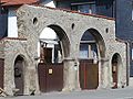
Stone gate in Einhausen

Einhausen Church


Web links
Individual evidence
- ^ Population of the municipalities from the Thuringian State Office for Statistics ( help on this ).
- ^ Otto Dobencker : Regesta diplomatica necnon epistolaria historiae Thuringiae. Volume 1: (approx. 500-1152). Gustav Fischer, Jena 1896, p. 350 f., No. 1668 .
- ^ Einhausen and his church - Festschrift for the 275th anniversary.
- ↑ Kai Lehmann : Innocent. Witch hunt south of the Thuringian Forest. Over 500 researched cases from the 16th and 17th centuries. Wehry-Verlag, Untermaßfeld 2012, ISBN 978-3-9813902-8-5 , p. 91 f .; Kai Lehmann: Exhibition "Luther and the Witches". Einhausen area, Library Museum Schloss Wilhelmsburg Schmalkalden, 2012; Ronald Füssel: The persecution of witches in the Thuringian area (= publications of the working group for historical witchcraft and crime research in Northern Germany. Vol. 2). DOBU-Verlag, Hamburg 2003, ISBN 3-934632-03-3 , pp. 240–244, (at the same time: Marburg, University, dissertation, 2000).

Belrieth | Birx | Breitungen / Werra | Brotterode-Trusetal | Christes | Dillstädt | Einhausen (Thuringia) | Ellingshausen | Erbenhausen | Fambach | Flea Seligenthal | Frankenheim / Rhön | Friedelshausen | Grabfeld | Kaltennordheim | Kühndorf | Leutersdorf (Thuringia) | Mehmels | Meiningen | Neubrunn (Thuringia) | Oberhof | Ober Maßfeld-Grimmenthal | Oberweid | Rhönblick | Rippershausen | Ritschenhausen | Pipe | Pink | Roßdorf (Thuringia) | Schmalkalden | Surge | Schwarza (Thuringian Forest) | Steinbach-Hallenberg | Sülzfeld | Undersize field | Utendorf | Vachdorf | Wasungen | Zella Mehlis