
Erdwerk Ohrbacher Schanze
| Erdwerk Ohrbacher Schanze | ||
|---|---|---|
 Overview of the plant |
||
| Alternative name (s): | Heuneschüssel, Römerschanze, Vielbrunner Schanze, Alte Schanze | |
| Creation time : | Roman or early medieval | |
| Castle type : | Hilltop castle | |
| Conservation status: | Castle stable, wall and moat remains | |
| Place: | Miltenberg - "Geißberg" | |
| Geographical location | 49 ° 42 '46.6 " N , 9 ° 8' 11.9" E | |
| Height: | 429 m above sea level NHN | |
|
||

The Erdwerk Ohrbacher Schanze, also called Römerschanze , Heunenschüssel or Vielbrunner Schanze , is a Roman or early medieval Wallan installation (Erdschanze) on the ridge of the Geissberg to the east, above the Ohrbach Valley between Vielbrunn ( Bremhof ) on the Hessian side and the Rüdenau district to the west of the urban area of Miltenberg in the district of Miltenberg in Bavaria .
location


The so-called Schanze is located near a prehistoric high path in the Main Valley, which runs along the ridge from Bremhof to Miltenberg (in a west-east direction). A few meters west of the plant on the saddle of the Geißberg it at that, the natural monument Lauseiche is, crosses a number Altwege in north-south direction between Laudenbach ( Main Limes ) and the Ohrenbachtal that populated today little and wooded plateau between Ohrenbach ( Hesse and in the local dialect called Ohrnbach , as the earthworks is sometimes called without "e") and the Main grazes west.
construction

The rectangular weir system, visibly rounded at the corners, was specified by Knapp in 1813 with a side length of 90 paces (just under 66 meters ) in west-east direction and 80 paces (around 58.5 meters) in north-south direction. Surrounded by a ditch about 1.5 meters deep , there are three earth walls about three meters high, two outer ones with a single pincer gate that is about 3.50 m wide and about 3.50 m wide in the middle of the eastern narrow side towards the Praetorial Front with many Pieces of sandstone and an inner wall. The moat is interrupted at the east gate. In the interior, divided by a small section trench, there are still remains of a well , which was secured by an inner, completely surrounding wall-trench system, which also protected three quarters of the system.
Today's information, based on measurements of the terrain relief in the Bayernviewer , results in an extension of 88.6 m (ditch-ditch) and 77.3 m (wall-wall) and an extension of 76.5 m (GG) respectively for the long side 66 m (WW) to the short side of the earthwork. This would make the complex comparable to the castles of the Odenwald Limes or even slightly larger in its dimensions (cf. e.g. the Eulbach fort). Postulated fortifications at the same level as the Limes, which Knapp no longer found and therefore rejected, cannot be found on the high plateau.
Findings and interpretations
The complex, described and documented by Johann Friedrich Knapp in 1813 at the latest and published in the Limeswerk in 1900 , was examined during excavations / explorations by Georg Hocks in 1912/1913 , whereby only Roman ceramics from the 2nd century were found. Two search cuts by Hocks at the trench are still visible in the geo-relief today.
The location between the two Limes lines , which is atypical of its kind, suggests that the Roman origin of the complex is not certain. Dietwulf Baatz did not rule out Roman origins in 1984, but asked for more detailed investigations. The size, appearance (rounded corners) and the pincer gate, with the exception of the atypical inner moat, reveal similarities with the forts on the Limes.
The fact that the facility could have served as an outpost of the Odenwald Limes to monitor the high path or as a labor camp and sawing place has recently been under increasing discussion. It is assumed that logging commands of the Roman army in the Odenwald felled wood for larger towns such as Mogontiacum (today's Mainz) because there was not enough material available in the surrounding area. The wood could easily be rafted to the Rhine via the Main . Referring to Bingemer, Theodor K. Kissel even referred to the ski jump as a wood processing company in his dissertation in 1995 . For this purpose, four inscription stones are also cited, which were found in the castles Trennfurt , Obernburg and Stockstadt , from vexillations of the Legion XXII (Antoniniana) Primigenia Pia Fidelis stationed in Mogantiacum and are dated to 206-214 AD. The Trennfurt Fort is also seen as a stacking and loading area on the Main because of its unusual, very strongly rectangular shape. In 1900 Wilhelm Conrady still thought he could find a connection route from the Trennfurt fort to the Hainhaus fort .
Monument protection
In the Bavarian monument list of the Bavarian State Office for Monument Preservation , the object is 6-6220-0003 D under the number as nachqualifiziertes ground monument called Erdwerk "ears Bacher Lair" late Roman Iron Age or early medieval time position named.
Investigations and targeted collection of finds are subject to approval, random finds to be reported to the monument authorities:
“Any change to or in the vicinity of architectural and ground monuments requires permission under monument law in accordance with Article 6 and Article 7 BayDSchG. Anyone who finds ground monuments is obliged to notify the lower monument protection authorities or the Bavarian State Office for Monument Preservation immediately in accordance with Art. 8 BayDSchG. "
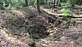
Fountain remnants collapsed inside (see map, point 2)

Today's "access area" at the SW corner from the Höhenweg (see map, point 8)

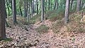
The still faintly visible dividing section trench inside the earthworks (see map, point 3)
The trench-free area of the east gate (see map, point 1)
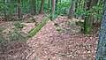
Castle right Picture side: The wall-ditch-wall system of the outer defense can still be seen clearly.


literature
- Dietwulf Baatz : Die Römer in Hessen , Theiss Verlag, 1984, p. 443 and 462
- Heinrich Bingemer: The Ohrbacher Schanze , in: Saalburg-Jahrbuch 10, 1951, pp. 29–35.
- Johann Friedrich Knapp : Roman monuments of the Odenwald, in particular the County of Erbach and Lordship of Breuberg. Heidelberg 1813 (new edition in 1854 by Heinrich Eduard Scriba), pp. 79–81 (= §41)
- F. Lintz: West German magazine for history and art , Volume 8, 1889, p. 69 f.
- Friedrich Mössinger: Die Römer im Odenwald (= writings for local history and homeland care in the southern Hessian area ) Issue 13/14, Verlag Südhessische Post, Heppenheim 1954 (new edition 1967), p. 52 ff.
- K. Schwarz: The Heuneschüssel, also known as the Ohrbacher Schanze , In: Guide to prehistoric and early historical monuments, Volume 8: Miltenberg, Amorbach, Obernburg, Aschaffenburg, Seligenstadt , Mainz 1967. P. 137–145.
- Kurt Stade : The Ohrbacher Schanze . In: The Upper Germanic-Raetian Limes of the Roman Empire , Volume A III (route 6), 1933, p. 23 ff.
- Thomas Steinmetz: The eastern border of the Mark Michelstadt and the border points there - 1200 years of Mark Michelstadt . In: Der Odenwald , Volume 64, Issue 4 / December 2017, pp. 135–151.
Web links
- Ohrbacher Schanze at odenwaldwiki.de
Individual evidence
- ↑ a b c d e Knapp: Roman monuments of the Odenwald, in particular the Grafschaft Erbach and Herrschaft Breuberg , p. 80
- ↑ Heunenschüssel at burgdaten.de
- ↑ a b Wilhelm Conrady: Das Kastell Trennfurt , In: Der Obergermanisch-Raetische Limes des Roemerreiches (Eds. Ernst Fabricius, Felix Hettner, Oscar von Sarwey), Department B, Volume 3, Kastell Nr. 37 (1900). P. 13
- ↑ Peter Endrich: Pre- and early history of the Bavarian Lower Maing area (= Volume 4 of the publications of the History and Art Association Aschaffenburg eV ), Verlag Pattloch, 1961 pp. 117 and 136f.
- ↑ Bingemer 1951, 29ff .; ORL A III section 6, 23ff. Plate 7.1 a-d; from: Alexander Reis: Forest and wood use in Upper Germany using the example of the Main Limes , Archaeological Reports 27, 2017, pp. 133–143
- ↑ Dietwulf Baatz: Die Römer in Hessen, Theiss Verlag, 1984, p. 462
- ↑ Theodor K. Kissel: Investigations into the logistics of the Roman army in the provinces of the Greek East: (27 BC - 235 AD) (= Volume 6 of Pharos (studies on Greco-Roman antiquity) ), Scripta Mercaturae Verlag, St. Katharinen 1995, ISBN 3-89590-019-2 . P. 205f.
- ↑ See also: Marcus Nenninger: Die Römer und der Wald: Investigations into dealing with a natural area using the example of the Roman north-west provinces , Franz Steiner Verlag, Stuttgart 2001, ISBN 3-515-07398-1 , pp. 175–181
- ↑ For example CIL 13, 6618 from Fort Trennfurt
- ^ Bavarian list of monuments: Miltenberg
- ↑ User information Bavarian Monument Atlas , accessed on October 9, 2015.


Palaces: Princely Leiningen's Palais Amorbach | Fechenbach Castle | City Palace Klingenberg | Laudenbach Castle | Löwenstein Castle | Moated Castle Oberaulenbach | Wasserschloss Sommerau | Wise Castle | Castle Wörth
Castles and ruins: Altenburg (Sodenburg) | Old Castle Kleinwallstadt | Bacheburg (Lower Castle) | Collenburg castle ruins | Frankenberg Castle | Henneburg castle ruins | Klingenburg castle ruins | Mildenburg | Mönchberg Castle (exited) | Riedern moated castle | Wildenberg castle ruins | Wildenstein castle ruins
Tower hill castles (all gone): Tower Hill Roßhof | Schneirersbuckel Tower Hill (Upper Castle)
Manor houses: Templar house
Castle stables (lost, unknown castles): Burgstall Alteburg (Eschau) | Altepurg Burgstall Alte Schanze | Ringwall Bürgstadter Berg | Burgstall Elsenfeld | Ringwall Greinberg | Heunenhügel | Ringwall Langer Berg | Burgstall Ölenbuckel (Eisenbach Castle, Upper Castle) | Erdwerk Ohrbacher Schanze (Heuneschüssel, Römerschanze) | Lower Eisenbach Castle
Fortified churches or fortified churches: St. Michaelis (Grubingen) | Fortified Church of St. Maria Magdalena (Trennfurt)
Waiting towers: Eichenbühl toll tower


Amorbach Palace | Alsbach Castle | Old castle | Old castle | Auerbach Castle | Bacheburg | Bad König Castle | Beerfurther Schlösschen | Birkenau Castle | Palais Boisserée | Breuberg Castle | Ringwall Bürgstadter Berg | Burgschell | Jagdschlösschen Carlsruhe | Curti lock | Dallau Castle | Darmstadt Castle (Groß-Umstadt) | Dauchstein Castle | Mountain fortress Dilsberg | Dorndiel Castle | Emichsburg | Eberbach Castle | Erbach Castle | Erdwerk Ohrbacher Schanze | Ernsthofen Castle | Eulbach Hunting Lodge | Fechenbach Castle | Frankenberg Castle (Amorbach) | Frankenstein Castle | Freienstein Castle | Freudenberg Castle | Fürstenau Castle | State Park Princely Camp | Fürstenstein Castle | Gammelsbach Hunting Lodge | Ringwall Greinberg | Burgstall Güttersbach | Guttenberg Castle | Grand Ducal Palace (Heidelberg) | Hammer lock | Hardheim Castle | Harfenburg | House to the Giant | Heddersdorf'scher Adelshof | Heidelberg Castle | Heiligenberg Castle | Heppenheim City Palace | Hinterburg | Hirschburg | Hirschhorn Castle | Hochhausen Castle | Hornberg Castle | Hundheim Castle | Jossa Castle | Kirchbrombach Castle | Jagdschloss Krähberg | Kronenburg | Kurmainzer Amtshof | Landsehr Castle | Lichtenberg Castle | Limbach Castle | Lindenfels Castle | Lohrbach Castle | Löwenstein Castle | Lützelbach Castle | Wall hexagon | Max-Wilhelmshöhe hunting lodge | Michelstadt Castle | Mildenburg | Minneburg | Mittelburg | Burgstall Mörlenbach | Palais Morass | Mühlhäuser Schlößchen | Neuburg Castle (Baden) | Nieder-Modau Castle | Upper Heidelberg Castle | Obrigheim Castle | Ohrsberg Castle | Veste Otzberg | Palatinate Castle | Reichenberg Castle | Reichenstein Castle | Riedern moated castle | Rodenstein Castle | Rodenstein Castle | Rohrbach Castle | Rohrbach Castle | Schaafheim Castle | Schanzenköpfle | Schauenburg | Schlierbach Castle | Castle Ober-Beerbach | Schloss-Naus castle | Schneirersbuckel tower hill | Schnellerts Castle | Schönberg Palace | Swallow's Nest | Schwarzach moated castle | Schweinberg Castle | Starkenburg | Stolzeneck Castle | Strahlenburg | Stutz Castle | Amorbach Templar House | Tannenberg Castle | Lower Hardheim Castle | Vorderburg | Wachenburg | Burgstall Waldau | Waldeck Castle | Waldleiningen Castle | Wald-Michelbach Castle | Wambolt's Castle | Hamlet hill | Weinheim Castle | Wiser Castle | Wildenberg Castle | Windeck Castle | Wörth Castle (Wörth am Main) | Zwingenberg Castle