
Gardens behind the fortress
|
Gardens behind the fortress
City of Nuremberg
Coordinates: 49 ° 27 '38 " N , 11 ° 4' 54" E
|
|
|---|---|
| Height : | 320 m above sea level NHN |
| Area : | 1.08 km² |
| Residents : | 17,461 (Dec. 31, 2005) |
| Population density : | 16,168 inhabitants / km² |
| Incorporation : | October 1, 1825 |
| Postal code : | 90408 |
| Area code : | 0911 |
 District 3420 Gardens behind the fortress in Nuremberg
|
|
Gardens behind the Veste has been a district north of Nuremberg Castle since 1825 and the name of the district 3420 , which has shares in the statistical districts 8, 25 and 26. The buildings are worth seeing, with numerous different stylistic elements from the period from 1860 onwards.
geography
Gardens behind the fortress is north of the old town and is (following clockwise and starting in the north) surrounded by the districts of Kleinreuth and Großreuth behind the fortress , Maxfeld , Sebald and St. Johannis .
structure
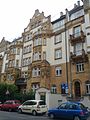
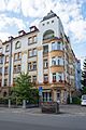
Gardens behind the fortress is a densely built-up Wilhelminian-style district in a block structure. The street blocks follow a varied rectangular grid that is broken up by several street diagonals and geometric squares. The closed development varies from four to six storeys. Detached villa-like townhouses have only been built in isolated cases, for example along the (lower) Pirckheimerstrasse. The reconstruction did not call into question the block structures of the time it was built. Individual replacement buildings were usually built on the original building lines. Only in the area of Pirckheimerstraße / Pilotystraße were few point and row houses built in the late 1950s and early 1960s, but they could not change the overall character of the district.
Gardens behind the fortress was the preferred residential area of upper-class families and upper middle-class families when they were built. After these population groups had migrated "into the countryside" in the post-war period, it became a popular area for students from the early 1980s, and many of the apartments, some of which were over 200 m² in size, were used by shared apartments. In the late 1980s and 1990s, many houses were extensively renovated; afterwards the quarter attracted many affluent citizens, but also creative people. Since that time, many apartments have also been converted into offices, law firms or medical practices. The few industrial properties were all abandoned by the end of the 1990s, some were converted into residential or office lofts, otherwise several larger office complexes were built from 2000 onwards, which resulted in a relatively high density of jobs in the service sector. Today, the gardens behind the fortress are very popular because of their proximity to the center and the intact supply infrastructure (shops, services), their diverse gastronomic offer and the Wilhelminian style atmosphere.
history
The area originally consisted of baroque gardens (similar to those in St. Johannis), orchards and fields.
Towards the end of the 18th century there were 10 properties in gardens behind the fortress. The high court exercised the imperial city of Nuremberg , but this was disputed by the Brandenburg-Bayreuth Oberamt Baiersdorf . The sole landlord was the land tax office of the imperial city of Nuremberg.
In 1806 the gardens at the gardens behind the fortress became part of Bavaria . As part of the municipal edict, the tax district gardens behind the fortress was formed in 1813 . In the same year the rural community gardens behind the fortress was formed, which coincided with the tax district. It was subordinate to the Nuremberg Regional Court in administration and jurisdiction and to the Erlangen Rent Office for financial administration . In the voluntary jurisdiction, 1 property from 1822 to 1840 was subordinate to the Patrimonial Court (PG) Buch , 2 properties from 1821 to 1848 to the PG Gebersdorf , 7 properties from 1825 to 1835 to the PG Gibitzenhof , 1 property from 1818 to 1828 to the PG Kraftshof , 5 properties from 1823 to 1835 to the PG Lohe , 5 properties from 1823 to 1835 to the PG Nemsdorf and 1 property from 1822 to 1835 to the PG Zerzabelshof . On October 1, 1825, gardens behind the fortress were incorporated into Nuremberg .
At the beginning of the 20th century, block development began as part of the city's expansion. The gardens were completely built over in the Wilhelminian era, the historical (now rather misleading) name of the dense and non-garden city-like district comes from this. Colloquially, however, the quarter is often only called “Nordstadt”, summarizing with Maxfeld and eastern parts of St. Johannis.
The stately four- to six-storey residential buildings with front gardens offer spacious apartments for high demands and are richly and imaginatively decorated. In the area of the first expansion zone in the south-east (southern Friedrichstrasse) there are still a few relatively simple houses in the Nuremberg style with echoes of the neo-Gothic style . Around the turn of the century, in addition to the neo-Gothic and neo-Renaissance styles that had prevailed until then , stately neo-baroque houses with high storeys were built, then fin-de-siècle architecture and, from around 1904/05, a number of Art Nouveau houses . The Art Nouveau district was one of the few inner city districts that survived the air raids of the Second World War relatively unscathed and still today has self-contained Wilhelminian street scenes. The monumental neo-baroque regional finance office , built between 1923 and 1926 , which was fitted into the quarter between Kreling-, Meuschel- and Schweppermannstraße and with the semicircular square, forms the urban development end of Hastverstraße. The northern border of the urban expansion area was formed by Kobergerstrasse and the hexagonal Kobergerplatz, the northern half of which was no longer built on because of the First World War and due to the changed urban planning concepts of the Weimar period. To the north of Grolandstrasse and west of the Nordbahnhof, the settlement at the Nordbahnhof was built in 1927-29 as part of the urban housing program, based on plans by Ludwig Wagner-Speyer in a condensed row construction.
Population development
| year | 1818 | 1824 | 1840 | 1871 | 1885 |
|---|---|---|---|---|---|
| Residents | 445 | 336 | 440 | 3251 | 3221 |
| Houses | 44 | 84 | 52 | 260 | |
| source |
religion
The residents of the Evangelical Lutheran denomination are parish according to St. Matthew , the residents of the Roman Catholic denomination are parish according to St. Martin .
Attractions
- Art Nouveau buildings (Meuschelstraße, Hastverstraße, Krelingstraße, Pilotystraße, Friedrichstraße (northern section) and Schweppermannstraße, Kobergerplatz, partly also Kaulbachstraße / Kaulbachplatz and Uhlandstraße)
- Archive park with Noris fountain
- Uhland School (Uhlandstrasse 33, 1911)
- Former regional finance directorate, today federal finance directorate (Krelingstrasse 50, 1923–1926)
- Kaulbachplatz underground station (2011)
Numerous Art Nouveau and Wilhelminian style houses in gardens behind the fortress are protected as individual monuments. The Art Nouveau district as a whole is under ensemble protection within the meaning of the Bavarian Monument Protection Act . Valuable individual features of Art Nouveau are:
- Friedrichstrasse 50 (1901)
- Friedrichstrasse 55 (1907)
- Hastverstrasse 21 (1904)
- Hastverstrasse 34 (Weltkugelhaus, 1905)
- Kaulbachstrasse 26 (1906)
- Kaulbachstrasse 32 (1906)
- Krelingstrasse 33 (1906)
- Krelingstrasse 35 (1906)
- Meuschelstraße 23 (Architects Popp and Wisdom, 1904)
- Meuschelstraße 25 (Architects Popp and Wisdom, 1904)
- Meuschelstraße 34 (architect Egelsehr, 1906)
- Meuschelstraße 38 (architect Georg Ros , 1905)
- Rollnerstrasse 39 (1906)

Corner Kaulbachstrasse Meuschelstrasse

Kaulbachplatz

Corner of Krelingstrasse and Pirckheimer Strasse
Ensemble on Krelingstrasse
Corner of Krelingstrasse Meuschelstrasse

Ensemble in Meuschelstrasse

Ensemble in Uhlandstrasse

Bucher Strasse


Public facilities
- Nuremberg office of the Bavarian State Office for Taxes and
- Federal Finance Directorate Southeast (until December 31, 2007: Oberfinanzdirektion Nürnberg); both are based in the same building on Krelingstrasse
- State Archives (Archivstrasse)
- State Building Authority (Pirckheimerstraße)
- District library (Maxfeldstrasse)
- Evangelical city mission (administration and various charity institutions, spread over several houses along Pirckheimerstraße)
education
- Hans-Sachs-Gymnasium
- Labenwolf High School
- Friedrich Hegel School ( primary school )
- Vocational high school
- Vocational schools on Pilotystraße
- Uhlandschule (primary school and separate secondary school )
traffic
Gardens behind the fortress has been accessible since December 10, 2011 by the subway (line U 3 in driverless operation) in an east-west direction. The Kaulbachplatz train station is located in the middle of the district in the Art Nouveau district. The Maxfeld and Friedrich-Ebert-Platz underground stations are on the eastern and western edges of the district. The city bus lines 46 and 47 cross gardens behind the fortress in north-south direction. The tram line 9 was shut down in this area despite significant popular protests. As a tangential tram connection there is still line 4 via Friedrich-Ebert-Platz, which is on the western edge of the district. In the past, there was also the Nuremberg North freight station on Grolandstrasse with a connection to the Nuremberg Ring Railway.
The Franconian Marienweg runs through gardens behind the fortress .
literature
- Günther P. Fehring , Anton Ress , Wilhelm Schwemmer: The city of Nuremberg (= Bavarian art monuments . Volume 10 ). 2nd Edition. Deutscher Kunstverlag, Munich 1977, ISBN 3-422-00550-1 , p. 289-291 .
- Wiltrud Fischer-Pache: Gardens behind the fortress (hdV) . In: Michael Diefenbacher , Rudolf Endres (Hrsg.): Stadtlexikon Nürnberg . 2nd, improved edition. W. Tümmels Verlag, Nuremberg 2000, ISBN 3-921590-69-8 , p. 319-320 ( online ).
- Hanns Hubert Hofmann : Nuremberg-Fürth (= Historical Atlas of Bavaria, part Franconia I, 4). Commission for Bavarian State History, Munich 1954, DNB 452071224 , p. 148-149 ( digitized version ). Ibid. S. 238 ( digitized version ).
Web links
Individual evidence
- ^ City of Nuremberg, Office for Urban Research and Statistics for Nuremberg and Fürth (ed.): Statistical Yearbook of the City of Nuremberg 2016 . December 2015, ISSN 0944-1514 , 18 Statistical City Districts and Districts, p. 19-20 , p. 19 ( nuernberg.de [PDF; 6.3 MB ; accessed on November 1, 2017]).
- ^ City map service Nuremberg
- ↑ Gardens behind the fortress in the BayernAtlas
- ↑ HH Hofmann, p. 148f.
- ↑ W. Fischer-Pache, p. 319f.
- ↑ HH Hofmann, p. 238; Address and statistical handbook for the Rezatkreis in the Kingdom of Baiern . Buchdruckerei Chancellery, Ansbach 1820, p. 62 ( digitized version ).
- ^ Wilhelm Volkert (ed.): Handbook of Bavarian offices, communities and courts 1799–1980 . CH Beck, Munich 1983, ISBN 3-406-09669-7 , p. 602 .
- ↑ Only inhabited houses are given. In 1818 these are known as fireplaces , in 1840, in 1852 as houses , and from 1871 to 1885 as residential buildings.
- ↑ Alphabetical index of all the localities contained in the Rezatkkreis according to its constitution by the newest organization: with indication of a. the tax districts, b. Judicial Districts, c. Rent offices in which they are located, then several other statistical notes . Ansbach 1818, p. 28 ( digitized version ).
- ↑ HH Hofmann, p. 238.
- ↑ Eduard Vetter (Ed.): Statistical handbook and address book of Middle Franconia in the Kingdom of Bavaria . Self-published, Ansbach 1846, p. 15 ( digitized version ).
- ↑ Kgl. Statistical Bureau (ed.): Complete list of localities of the Kingdom of Bavaria. According to districts, administrative districts, court districts and municipalities, including parish, school and post office affiliation ... with an alphabetical general register containing the population according to the results of the census of December 1, 1875 . Adolf Ackermann, Munich 1877, 2nd section (population figures from 1871, cattle figures from 1873), Sp. 1143 , urn : nbn: de: bvb: 12-bsb00052489-4 ( digital copy ).
- ↑ K. Bayer. Statistical Bureau (Ed.): Localities directory of the Kingdom of Bavaria. According to government districts, administrative districts, ... then with an alphabetical register of locations, including the property and the responsible administrative district for each location. LIV. Issue of the contributions to the statistics of the Kingdom of Bavaria. Munich 1888, Section III, Sp. 1082 ( digitized version ).
.svg)
.svg)
Almoshof | Altenfurt | Bärenschanze | Pearwood | White lead | Boxing Village | Brunn | Book | Buchenbühl | Doos | Dutzendteich | Eberhardshof | Eibach | Eibacher Forest | Erlenstegen | Falkenheim | Fischbach | Open air settlement | Gaismannshof | Galgenhof | Gardens near Wöhrd | Gardens behind the fortress | Garden city | Gaulnhofen | Gebersdorf | Gerasmühle | Gibitzenhof | Gleißbühl | Gleißhammer | Glockenhof | Gostenhof | Greuth | Großgründlach | Großreuth near Schweinau | Großreuth behind the fortress | Gugelstrasse | Guntherstrasse | Hammer | Hasenbuck | Herpersdorf | Herrnhütte | Himpfelshof | Holzheim | Courtyards | Courtly | Hummelstein | St. Jobst | St. Johannis | Katzwang | Kettelersiedlung | Kleingründlach | Kleinreuth near Schweinau | Kleinreuth behind the fortress | Kleinweidenmühle | Klingenhof | Royal court | Koppenhof | Kornburg | Powerhouse | Settlement of war sacrifices | Krottenbach | Long water | Laufamholz | St. Leonhard | Leyh | Lichtenhof | Tan | Loher Moos | Lohhof | Lorenz | Ludwigsfeld | Maiach | Marienberg | Marienvorstadt | Maxfeld | Middle mill | Mögeldorf | Moorenbrunn | Mooshof | Muggenhof | Mühlhof | Net stall | Neukatzwang | Neulandsiedlung | Neunhof | Neuröthenbach | Neuselsbrunn | North Station | Northeast Station | Oberbürg | Obermühle | St. Peter | Pillenreuth | Pirckheimerstrasse | Rabus | Marshalling yard settlement | Rechenberg | Rehhof | Reichelsdorf | Reichelsdorfer Keller | Rennweg | Reutles | Rosenau | Röthenbach near Schweinau | Sandberg | Sandreuth | Sheep farm | Schmalau | Schnepfenreuth | Schniegling | Schoppershof | Schweinau | Sebald | Seeleinsbühl | Spitalhof | Quarries | Steinbühl | Stone slab | Sündersbühl | Tafelhof | Clay | Tullnau | Lower guarantee | Veilhof | Vistula Garden | Weigelshof | Weiherhaus | Werderau | Westfriedhof | Wetzendorf | Wöhrd | Worzeldorf | Zerzabelshof | Brick | Customs House