Georgsheil
The village of Georgsheil has belonged to the district of Uthwerdum in the municipality of Südbrookmerland in East Frisia since the municipal reform of July 1, 1972 . Georgsheil is considered a traffic junction in the Aurich district , as it is located almost exactly in the center of the triangle of cities Aurich , Emden and the north .
history
Around 1840 there was only one cobblestone road in East Frisia that led from Aurich to Leer. Since it was not only the Hanoverian royal family who discovered Norderney as a holiday destination, the construction of a road from Emden to Aurich and the branch to the north began . Up until this point in time, the unpaved path had to be rebuilt every time the royal couple passed through. As a result, the Brookmerlander Hof and the Uphoff Inn (1841) were built in the Emden - north branch . Two restaurants, a bakery and a grocer were set up there. From the official side, there were initially doubts about the profitability and the license was granted slowly. It turned out, however, that at the traveling speeds at that time, the central location in the triangle of Emden, Aurich and Norden was almost imperative for resting and re-harnessing the horses. In addition to the settling businesses, residential houses were also built. The place attracted the purchasing power of the former municipality of Uthwerdum.
The place name Georgsheil was given on September 21, 1844 and is derived from the Hanoverian King Georg . The salvation of the birth of his son is said to have been proclaimed to him here during a rest. According to other sources, the addition of salvation was meant to express the devotion of the king's subjects.
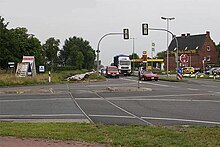
The roads that meet in the village are now the B 72 ( Cloppenburg - Aurich - Norddeich) and the B 210 (Emden - Aurich - Wilhelmshaven ). The house mentioned in the junction Emden - Norden still exists today and is the design for the confluence of the two federal roads today.
From 1883 to 1906 the East Frisian Coast Railway was built using exactly the same connection scheme. The Georgsheil train station bus stop still exists today and is an important transfer hub for bus passengers between Emden, Aurich and the north.
The convenient location of the station was the basis for the establishment of the Engerhafe concentration camp during World War II .
Population development
The municipality of Südbrookmerland does not show separate figures for the village of Georgsheil in its population statistics. As of July 1, 2012, Georgsheil and the neighboring village of Uthwerdum had 1294 inhabitants (651 male, 643 female).
Economy and Infrastructure
economy
West of Georgsheil there is a large industrial area on federal road 210. The Gusszentrum Ostfriesland (GZO) of the Enercon Group has been located there since 2009. Thus, the siding was put to use in the municipality.
In earlier times the local dairy was important; then one of the largest in East Frisia. One of the oldest cattle insemination stations is located in Georgsheil. The station was founded in 1948 by farmers from Brookmerland and today, as the insemination and embryo transfer station in Georgsheil, it is a location of the Association of East Frisian stock breeders (VOSt eG), which is based in Leer. The ET station keeps around 200 black and white bulls and has an annual production of around 800,000 cans of bull seeds, which are used by cattle breeding farms around the world.
traffic
Georgsheil is considered a traffic junction in the Aurich district , as it is located almost exactly in the center of the triangle of cities Aurich , Emden and the north . In Georgsheil, the federal road 210 from the direction of Emden and the B 72 from the north meet. Both lead on the same route, but with two numbering, to Aurich. Passenger traffic to Norddeich , Norderney and Juist runs through Georgsheil.
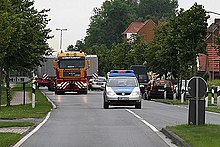
Georgsheil is on the Abelitz – Aurich railway line . There was freight traffic on this railway line until 1996, then switches were dismantled and the line overgrown with grasses and bushes. In the past few years the reactivation of the railway line for freight traffic was discussed, until the decision was made in 2005. The corresponding plan approval procedure was opened in May 2006. The wind turbine manufacturer Enercon in Aurich, who wants to transport larger parts of windmills to the port of Emden (for export) by rail , is particularly interested in the railway line . At present, some of the transports are still on federal highways, which leads to traffic problems. The Georgsheil transport hub should also benefit from this relief. Enercon has promised a donation of two million euros out of the planned 7.5 million euros for reactivating the line. The route was reopened on April 4, 2008 with the participation of the then Prime Minister of Lower Saxony , Christian Wulff .
Public facilities
After the Aurich and Norden districts merged, a new fire brigade training center (FAZ) was built in the industrial area. Basic training and advanced courses for the fire departments in the Aurich district are offered here. The fire brigade technical center (FTZ) in the same building is also state-of-the-art and is available to all fire brigades in the Aurich district for repairs and equipment replacement.
In October 2013 it became known that the Aurich district and the city of Emden are considering a joint central clinic in Georgsheil and want to check the feasibility . If a joint clinic is built there, the two locations of the Ubbo-Emmius-Klinik in Aurich and Norden and the Hans-Susemihl-Hospital in Emden would be closed. In June 2017, the construction of the central clinic was rejected in a referendum.
Web links
Individual evidence
- ↑ Uthwerdum at Ostfriesische Landschaft , accessed on January 29, 2019
- ↑ Numbers and dates . Südbrookmerland municipality. Retrieved January 29, 2019.
- ^ Ostfriesische Nachrichten of April 9, 2010: Enercon's casting center inaugurated.
- ↑ oz-online.de - Idea: Central Clinic in Georgsheil , accessed on October 30, 2013
- ↑ Emder Zeitung of June 11, 2017
Coordinates: 53 ° 29 ' N , 7 ° 20' E

