
Norderney
| coat of arms | Germany map | |
|---|---|---|

|
Coordinates: 53 ° 42 ' N , 7 ° 9' E |
|
| Basic data | ||
| State : | Lower Saxony | |
| County : | Aurich | |
| Height : | 5 m above sea level NHN | |
| Area : | 26.29 km 2 | |
| Residents: | 6090 (Dec. 31, 2019) | |
| Population density : | 232 inhabitants per km 2 | |
| Postal code : | 26548 | |
| Area code : | 04932 | |
| License plate : | AUR, NOR | |
| Community key : | 03 4 52 020 | |
| LOCODE : | DE AUR | |
| City structure: | 2 districts : fishing port Nordhelmsiedlung |
|
City administration address : |
At Kurplatz 3 26548 Norderney |
|
| Website : | ||
| Mayor : | Frank Ulrichs ( SPD ) | |
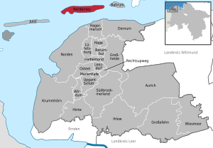
| Location of the city of Norderney in the Aurich district | ||
  |
||

.png)

Norderney [ nɔɐ̯dɐˈnaɪ ] ( East Frisian Low German : Nrogenee [ nœədəˈneɛɪ ]) is one of the East Frisian islands in the North Sea , which are off the mainland of Lower Saxony between the Ems and Weser estuaries in the German Bight . With an area of 26.29 square kilometers, Norderney is the second largest island in this group of islands after Borkum .
The city of Norderney, a unified municipality , covers the entire island of Norderney. After the regional reform in Lower Saxony in 1978, it belongs to the Aurich district and with 6090 inhabitants is the largest municipality in the East Frisian Islands in terms of population . The municipality, which was granted town charter in 1948 , includes the town center of Norderney, the two districts Fischerhafen ( harbor and the adjacent industrial area) and Nordhelm , the former barracks settlement . The three districts are in close proximity in the far west of the island. The remaining area of the island is hardly inhabited or built up. Exceptions are a few buildings around the Norderney lighthouse in the middle of the island and the island golf course with the adjacent settlements Am Leuchtturm and Grohde in the center of the island and the nearby Norderney airfield , the Norderney Dünensender youth hostel to the west and the former state domain buildings to the east Eiland and Tünnbak .
The main economic branch of today's state spa and climatic health resort, which was named the first Royal Prussian seaside resort on the German North Sea coast on October 3, 1797, is tourism . The North Sea spa has four beaches. In 2007 more than 400,000 day and spa guests were counted, in 2008 and 2009 a total of over three million overnight stays were registered; including around 1.6 million overnight stays in larger accommodation providers (2019).
To the east of the city limits, a total of 85 percent of the island area belongs to the Lower Saxony Wadden Sea National Park .
geography
| area | surface |
|---|---|
| Built up area | 152 |
| including residential space | 65 |
| of which commercial building space | 60 |
| including recreational area | 27 |
| Common area | 24 |
| traffic area | 91 |
| of which road traffic | 73 |
| of which stationary traffic | 20th |
| of which air traffic | 18th |
| Areas for supply and disposal | 1 |
| Green spaces | 60 |
| including parks | 19th |
| including allotments | 8th |
| including sports fields | 12 |
| including cemeteries | 2 |
| of which other green spaces | 19th |
| Agricultural area | 405 |
| Water surface | 11 |
| of which freshwater | 3 |
| Other area | 1886 |
| of it land | 877 |
| Total area excluding coastal waters | 2629 |
Location and surroundings


Norderney is one of the East Frisian Islands, which are located a few meters above sea level in northwest Germany in the German Bight . The seven inhabited islands and the five uninhabited larger sandbanks , sand plateaus and high sands are in front of the mainland of the state of Lower Saxony off the coast of the East Frisia region . The island belongs to the district of Aurich . Seen from the west, Norderney is the third of the inhabited East Frisian Islands. Norderney extends over a total area of 26.29 square kilometers in a length of around 14 kilometers in an east-west direction. At the widest points on the west head and in the center of the island, the island extends up to 2½ kilometers in a north-south direction. This makes it the ninth largest of the German islands after Borkum and the second largest of the East Frisian islands after Borkum. A sandy beach of around 14 kilometers in length extends over the entire north side of the island, which is lined with an island revetment in the urban area , which serves to protect the island from floods and storm surges and as a pedestrian promenade .
Located in the western part of the city is also called Norderney and compared the most urban of the seven East Frisian island communities. The size of the urban area is a fifth of the island area and, together with the industrial area, has a maximum extension of about two and a half kilometers in the east-west direction and up to two kilometers in the north-south direction. The built-up area is a total of 152 hectares.
Norderney is separated from the neighboring island of Baltrum to the east by the narrow sea gate of the Wichter Ee . It is about 15 kilometers from the center of the city of Norderney to the island town of Baltrum. To the west, the island of Juist is around three kilometers away, and it is around eleven kilometers as the crow flies to the center of the municipality of Juist. The wide Norderneyer Seegatt stretches between Norderney and Juist . The westernmost part is called Spaniergat , the north in the middle is called Schluchter , to the east of it the Dovetief with the main fairway of the Seegatt stretches along between the islands.
In the eastern half of the island, in the dune area there, there is a wide legde , also called Schlopp , which extends from the beach in the north to Heller in the south. The area around this dune breakthrough is completely flooded with higher storm surges. The entire eastern half of Norderney and the Wadden Sea bordering south of the island with the Platen Hohe Plate , Hohes Riff and Lütetsburger Plate as well as the channels Busetief , Wagengat and Ostbalje are part of the Lower Saxony Wadden Sea National Park .
The mainland is between three kilometers (from the wadden side east of Grohdepolders to Hagermarsch and Neßmersiel ) and six kilometers (from the port of Norderney to the northern district of Ostermarsch ). Neighboring municipalities on the mainland are the city of Norden , the municipality of Hagermarsch in the integrated municipality of Hage and a short section of the municipality of Dornum (all in the district of Aurich). In the northern part of the city, Norddeich, there is a ferry terminal at the pier and, just outside, to the east, there is an airport from which flights to Norderney are possible.

geology

Like the East Frisian Islands as a whole, Norderney is not a fragment of an earlier mainland and thus differs from the North Frisian Islands, for example . Norderney lies on a base formed in the Pleistocene and the following Holocene . The Pleistocene layers of meltwater sands, occasional Lauenburg clay , boulder clay as well as drift and river sands are now about ten to twenty meters below sea level, and the basal peat and brackish water sediments of the Holocene that are deposited above them are clearly submarine. Near the surface, in the middle of the island, for example at the height of the lighthouse, the subsoil up to a depth of 30 meters consists rather of mudflat and channel sand, i.e. purely marine deposits.
About 10,000 years ago, the mainland extended far into today's North Sea to the Dogger Bank and the English coast. As a result of the ice melt after the last ice age and the resulting rise in sea level, the present-day German Bight began to flood around 7,500 years ago . Due to the interaction of the current and wind coming from the west, sand masses were deposited, which developed into sandbanks and island-like plateaus . The sand accumulations, which were no longer flooded at high tide (see Kachelotplate ) , formed the basis for the settlement of pioneer plants, which strengthened the sandy soil with their roots, which in turn enabled the formation of dunes and the growth of the island.
As a result of the sometimes strong tidal currents from the north and west, Norderney drifts, like the other East Frisian Islands, in an easterly direction. The foundation of the island is on the west head from different sound, Klei - and clay layers were needed which island protection measures. The island's revetment, which was first created in 1858, made it possible to secure the western island head against the tidal forces and the associated coastal erosion . The eastern part of the island, on the other hand, gained around 5 to 6 kilometers in length from 1650 onwards due to alluvial sand and sediments. The naturally formed beach is over 200 meters wide in some sections.
The highest natural point on the island and the entire East Frisian island chain is the Walter Großmann dune named after the geodesist Walter Großmann , who came from the north in East Frisia . It is a sand dune located in the area of the White Dune in the middle of the island with a height of 24.4 m above sea level . The dune is also the highest point in East Frisia. The island is on average 3 m to 5 m above sea level, the island base protrudes an average of 1.5 m out of the sea. On some of the higher dunes, which are between 10 m and 20 m above sea level, viewing platforms have been set up, some with information boards about the island and the national park. Some of the distinctive dunes have been given names over time, such as Georgshöhe ( 20 m ) and Marienhöhe ( 11.5 m ) in the urban area and Mövendüne ( 11 m ), Senderdüne ( 21 m ) and Rattendüne ( 5.5 m ) in the eastern part of the city Island.
Due to the geological conditions on the island, a freshwater lens could develop underneath . This was caused by seeping rainwater, which in the sandy soil displaced the heavier salt water to a depth of a maximum of 80 meters. The size of the lens is subject to climatic fluctuations, but around 900,000 cubic meters of drinking water can be pumped annually on the island from the Ort waterworks and from the White Dune pumping station built in the center of the island in 1958 . The Norderneyer drinking water is considered to be particularly pure, as it is not contaminated by seeping fertilizers and sewage due to its location below the island base, unlike groundwater on the mainland. The groundwater has a slightly yellowish color, which is based on detached peat deposits and clay, which causes humic substances to form. In order to prevent the penetration of salt water and thus destruction of the lens during storm surges , the edge dunes of the island were reinforced over time.
climate

The island of Norderney is located in the area of the temperate, cool summer maritime climate influenced by the Gulf Stream and thus directly influenced by the North Sea. With small temperature fluctuations, there is high humidity. On average, the temperatures in summer are below and in winter above the values measured on the mainland. Overall, the Norderneyer climate is shaped by the prevailing wind from the south and southwest, which is created by low pressure areas over Iceland and Greenland . In spring and autumn, storms with hurricane strengths are quite common, these often occur with a storm surge. This creates waves that can tower up to 8.5 m in front of the island .
The average annual temperature is 10.9 ° C. The warmest month, unlike in most areas of Germany, is August with an average monthly temperature of 18.6 ° C. (The fact that August and not July is the warmest month is due to the extreme maritime nature of the climate). With an offshore south wind, temperatures over 30 ° C can be reached, as in 1969 with 33 ° C, in 2006 with 32.6 ° C and 33.7 ° C in 2013. The heat record is 34.1 ° C, the last measured on July 2, 2015. The coldest month is February with an average temperature of 2.0 ° C. In the period from 1961 to 1990, an annual mean of 0.6 hot days (tropical days) were measured on Norderney . The average annual rainfall is around 615 millimeters. The rainiest month is August with 83 millimeters, the least rainy is February with only 28 millimeters. On average there are 16.4 rainy days per month. With an average of 1701 hours per year, the mean sunshine duration is above the German mean of 1550 hours. Most hours of sunshine are reached in the months of May to August with up to 226 hours. In the winter months, however, the sun only shines for 38 to 76 hours.
The water temperature and the swell are measured at the two measuring stations in the Nordergrund, a shoal in the northwest of Norderney, and in Norderneyer Riffgat. It fluctuates between 3 and 7 ° C in the winter months and 13 to 17 ° C and over 20 ° C in very warm summers. This is due to the shallow water depth in the mudflats and the drained areas during low tide. The annual average water temperature is around 14 ° C. From 1961 to 2000, 26 winters with ice accumulation in the Wadden Sea were recorded at the observation station in Norderneyer Seegat. The frequency of ice formation is 65 percent. The longest duration of an ice winter was 74 days, the average is 21 days.
The climate classification of Wladimir Köppen According to the classification Cfb applies to Norderney. This classification according to climate zone (C), climate type (Cf) and climate subtype (b) indicates a warm and humid temperate climate with warm summers for Norderney due to the prevailing cyclonic westerly wind conditions .
The local stimulating climate and the proximity to the mainland contributed to the beginning of tourism as early as the 18th century.
| Norderney | ||||||||||||||||||||||||||||||||||||||||||||||||
|---|---|---|---|---|---|---|---|---|---|---|---|---|---|---|---|---|---|---|---|---|---|---|---|---|---|---|---|---|---|---|---|---|---|---|---|---|---|---|---|---|---|---|---|---|---|---|---|---|
| Climate diagram | ||||||||||||||||||||||||||||||||||||||||||||||||
| ||||||||||||||||||||||||||||||||||||||||||||||||
|
Average monthly temperatures and rainfall for Norderney
Source: weather-online.de
|
||||||||||||||||||||||||||||||||||||||||||||||||||||||||||||||||||||||||||||||||||||||||||||||||||||||||||||||||||||||||||||||||||||||||||||||||||||||||||||||||||||||||||||||||||||||||||||||||||||||||||||||||||
biology
Flora and fauna
| Distribution of the biotope types on Norderney | ||
|---|---|---|
| Biotope type | Area (ha) | Surface (%) |
| Rush quarry foredune | 95.8 | 4.5 |
| Beach grass white dune | 185.0 | 8.6 |
| Sea buckthorn-elder-coastal bushes | 16.6 | 0.8 |
| Gray dune grass corridor | 477.7 | 22.2 |
| Coastal dune heather | 14.8 | 0.7 |
| Coastal dune bushes | 77.2 | 3.6 |
| Moist dune valley | 94.9 | 4.4 |
| Wood of the humid dune valleys | 55.9 | 2.6 |
| Upper salt marsh | 406.2 | 18.9 |
| Lower salt marsh | 61.6 | 2.9 |
| Grassland | 221.0 | 10.3 |
| Ruderal and semi- ruderal corridor | 34.7 | 1.6 |
| Unlocated, planted wood (a) | 32.0 | 1.5 |
| Settlement areas | 350.1 | 16.3 |
| Waters | 28.0 | 1.3 |
| Sum of the biotope area | 2151.0 | 100.0 |
.JPG)
Like the other East Frisian Islands, Norderney did not emerge from the land mass, but rather a dune island that has grown over time from sand washed up by the ocean currents. The original island area was therefore barren and poor in vegetation. Over the centuries, wind and erosion created several chains of dunes, which were gradually overgrown by plants. Different vegetation zones, which represent different habitats due to their age, are distinguished from one another. These are foredunes , white dunes , gray dunes , brown dunes , dune slacks and watt and Heller surfaces .
The foredunes are the youngest dunes after their formation. It is washed-up sand that can still be flooded during storm surges. Since the fore dunes are extremely important for the continued existence of the island, they are reinforced at regular intervals with wooden containers on the base. There thriving salt-compatible pioneer plants such as beach couch grass or the sea rocket . When these dunes are no longer flooded by water and thus remain free of salt, common beach grass and beach rye will settle .
The beach grass with its extremely large root system ensures that solid and rising white dunes can form. Beach grass plantations serve to protect the edge dunes from the wind, which could carry them away again.
As a result of the growing vegetation towards the center of the island, humus forms on the dunes. These dunes are known as gray dunes . The predominant vegetation there consists of the sea buckthorn and the creeping willow . Grasses and lichens also grow in this area. In the humid dune valleys in the center of the island, smaller moors and salt marshes have formed, in which plants such as the round-leaved sundew , king fern , various mosses, berry bushes and club moss plants such as club moss and marsh moss thrive. In addition, the dog violet and the dune pansy ( Viola tricolor var. Maritima ), a variety of the wild pansy , can be found.
On the wadden side, the salt plants samphire as a pioneer plant and beach fescue are the most common plants. The samphire is used, among other things, for reclaiming new land, as it holds nitrogen in the roots, which helps bind the grains of sand. Only a few diked areas are used for agriculture, so horses and Galloway cattle are bred in Grohdepolder. The remaining island areas gained cannot be used effectively due to the salt content. In total there are over 500 different plant species on Norderney. As a result of reforestation in what is now Norderney's urban area, smaller artificial forest areas with a total size of 50 hectares emerged from the 18th century. These are in the western part of the island the Argonner grove near the west beach, a Ruppertsburger grove called pine forest on the eastern edge of the city and a forest consisting of alders and poplars northwest of the airfield. Together with the 30 hectares of natural forest on the island of Norderney, next to the island of Borkum, the largest forest area on the East Frisian Islands.

The fauna of the island and the adjacent Wadden Sea is very species-rich , especially from an ornithological point of view. During the migration period, large flocks of migratory birds rest mainly in the eastern part of the island. The Wadden Sea serves the flocks of birds as a rich source of food and the island as a breeding area. A total of around 95 species of birds breed on Norderney. The salt marshes and dikes are used by gray geese as grazing grounds. The most common bird species on the island are the Lach - with around 1200 breeding pairs and the herring gull . In addition to ducks , the blackbird , house sparrows , and increasingly crows , they mainly inhabit the urban area of Norderney. In contrast to other wild birds, they have lost their natural fear of humans and appreciate their proximity. In addition, there are larger stocks of lapwing , knutt , oystercatchers , dunlins , snipe birds and the extremely shy shelduck in the eastern part of Norderney . Other birds are diving ducks , redshank , eider ducks , the common scoter , rare in Germany ferruginous duck , the curlew , the Arctic tern , the golden plover , the wheatear and the bittern , which goes into the reed beds of the island in search of food. Some species of birds of prey such as falcons , some species of owls , the hen harrier and the marsh harrier can be seen on the island. In addition to the pheasant and some deer living on the island, rabbits can be seen feral in the dunes and partly in the middle of the city , whose ancestors were abandoned on the island around 1620 for the hunting pleasure of the island bailiffs. Since the animals have multiplied strongly due to the lack of natural enemies, the population must be reduced through systematic hunting of the Norderneyer Hegering or by mowing meadows within the Grohden. With the harbor seal and the gray seal, there are two mammal species that can be observed in the Norderneyer Wadden Sea. Larger populations of these animals can be seen at the Wichter Ee and in the Busetief, resting on the sandbanks there at low tide. After the population of the animals was decimated by the distemper in the late 1980s, the population was able to recover into the 21st century.
Around 70 species of fish are native to Norderney. The most common are gobies , various types of flatfish, such as the plaice , various crustaceans such as the common edible crab , the North Sea shrimp , known as "garnet", starfish , mussels and other types of mussels, as well as oysters . The Watts habitat is home to several types of worms, the best-known representative of which is the sand pierworm , which eats the sand of the Wadden Sea and thus digests the last organically usable remains. Its habitat is characteristically recognizable by the excrement from sand that it excretes.
Lower Saxony Wadden Sea National Park


Norderney is located in the Lower Saxony Wadden Sea National Park , which has been a UNESCO World Heritage Site since June 26, 2009 . The national park extends from Dollart in the west over the Ems estuary, the East Frisian Islands and the Jade Bay to the Elbe estuary in the east. The administration of the Lower Saxony Wadden Sea National Park has had a branch at Norderneyer Harbor since 1991. After the old building was demolished, the National Park House was completely rebuilt and opened to visitors at the beginning of March 2015. The different areas of life in the Wadden Sea and the open North Sea are shown in various aquariums, themed areas prepared using multimedia and interactive display boards. The focus of the exhibition is on the Wadden Sea habitat, the salt marshes and dunes as well as the open sea with the offshore wind turbines erected off the coast. In addition, film screenings are offered to around 75,000 visitors each year. There are several educational and hiking trails on Norderney, some of which with their names are reminiscent of the time of the French continental barrier, when smuggling flourished on the island due to its location. The Dünen-Hellerweg is interrupted by creeks at water levels of more than 70 cm above the mean high tide. There are information boards in the shelters along the wayside.
With the exception of the settlement and infrastructure areas and the airfield, the island of Norderney is part of the national park. The island is divided into three protection zones. Protection zone III includes the entire beach area in the northern part of the island of Norderney from the west beach to the north beach, the White Dune bathing area and the nudist beach to the dune crossing north of the Ostheller car park in the interior of the island. The further north-eastern beach area belongs to protection zone II. Protection zone III also includes the Fischerhafen district in the south-west of the island with the area of the windsurfing school and the golf course in the center of the island. It is a 9-hole golf course that was laid out in 1922 and has existed in its current form since 1927. It is the only links course in Germany.
According to the operator's plans, it was to be expanded into an 18-hole golf course. This project met with harsh criticism from the Norderneyer local group of the BUND and the national park administration, as the expansion and the associated redesign of the dune landscape accelerated the decline in species. BUND had been fighting against the expansion plan since 2003. After the expansion of the area to a total of 41 hectares was rejected by a public survey between September 26 and October 14, 2011, the district of Aurich refused the permit: The construction of two cycle paths could be impaired. There is the possibility of submitting a revised building application for the golf course extension.
For the intermediate zone the area east is one of the outskirts ( settlement dairy farm and in the dunes ) to the eastern edge of the Grohdepolders, except situated in that zone airfield, the hostel and the campsite in the dunes and the former State domains domain Grohde and domain Tünnbak with the adjacent camping Eiland .
The water protection and bird breeding area within the Südstrandpolder has been a nature reserve since 1961 and has been part of the national park's quiet zone since 1986. This makes it the oldest nature reserve on the island. In 1940/1941, the approximately 140 hectare area east of the port was diked from the south in order to build a new military airfield for the Norderney Sea Flight Station (SFS). After the Second World War, the plans were not adhered to and nature was left to its own devices. It was not until 1987/1988 that, in the course of strengthening the harbor dike, sand was removed from the area of the south beach polder and at the same time the shrubbery and shrubbery were removed. The original wetland vegetation was restored; the south beach polder today offers numerous species of birds breeding and resting places and has one of the largest wet heaths on the East Frisian Islands. In addition to the south beach polder, this includes the entire eastern part of the island with the Grohdepolder surrounded by the hunger dike, including the fore dunes that separate the beach from the center of the island, as well as part of the dunes east of the waterworks located in the center of the island. This part of the island serves as a resting and breeding area for many bird species. For this reason, the areas may only be entered on signposted hiking trails so as not to disturb the animals. Access to the remaining areas in this protection zone is prohibited.

Measures for island and coastal protection


Like all other East Frisian Islands, Norderney has always been subject to constant natural changes and protecting the island has been difficult in earlier centuries. Around 1800 there was a wide belt of dunes in the west of the island, behind which the first houses were built, protected from the wind. Like all other East Frisian Islands, Norderney migrates to the east as a result of the strong tidal currents from the north and west. Between 1650 and 1960, the eastern part of Norderney was extended by about six kilometers due to the steady flow. Norderney is separated by the Dovetief, which is up to 20 meters deep, about three kilometers further north than the neighboring island of Juist. As a result, it is directly exposed to the swell from west to northwest. Four times a day a strong tidal current with suction effect arises in this Seegat by one and the water running when changing from low tide and high tide and vice versa. The tidal volume amounts to 192 million cubic meters of water each. The western head of the island sits on a foundation of clay, clay and loam layers. The western part of the island can not withstand the migration to the east caused by the strong ocean current in the Norderneyer Seegat and the associated decrease in the beach in the long term. Changes in the supply of sand to Norderney from the west led in the course of the early 19th century to a high loss of sand and beach on the west side and to the demolition of the edge dunes in the course of the following years. Coastal erosion was counteracted with the construction of the first heavy island protection works , sheet piling , stone dams and groynes . Under the direction of the royal Prussian hydraulic engineer Adolf Tolle, who came from Berlin , the first island revetment (dune protection system) on the German North Sea coast was built on the west head of Norderney in 1858. The main reasons for the construction of the revetment were to protect state property, as well as the storm surge of 1840 and the New Years flood of January 1st and 2nd, 1855 . This storm surge wreaked havoc on the island village. The high water level was 4.26 m above sea level. Due to the rapid expansion of the island village, the naturally formed dune belt north of it was removed. This favored greater destruction during storm surges. A revetment of 950 meters in length was built around the northwestern head of the island. The entire west and north side of the island in the area of the city is lined with a total of six kilometers of revetments and 32 groynes, on the side of which facing away from the current sand settles. This makes the natural sand migration more difficult. The last of the stone groynes was completed in 1953. A large part of the old revetment, which extends over a total of five kilometers around the city of Norderney, consists of brown sandstones. Because of its distinctive shape, the revetment is known as the Norderneyer S-profile . In the course of the next few years, extensions and weather-related repair work on the groynes followed, which are still ongoing. The effort for this has increased over the years. In 1951 the first major sand flushing took place , which has been repeated every five to ten years since then, most recently in 2000. The washed-up sand is transported from deeper layers of the eastern Norderneyer Seegat with huge pumping stations to the area of the west and north beach. In the years 1951/1952 these were the first flushes in coastal protection in Germany in order to move the surf zone forward with a wide beach and thereby secure the other bank protection works. By nourishments prevents the inflowing water with the surf the lock latches and facing the promenade used as island revetment undermined.
During the particularly severe storm surges in January 1953 , February 1962 and the two January floods in 1976, large parts of the revetment on the north beach and the former west dyke in the area of the old airfield of the naval squadron stationed on Norderney during World War II were either affected or destroyed. In 1953 the dykes and flood gates were not built sufficiently high, so that the water masses flooded the urban area and caused severe damage to buildings. The storm surge of 1962 took a similar course, during which parts of the revetment were severely damaged, among other things. As a result of this destruction, the dikes and the revetments in the western part of the island were rebuilt, reinforced and raised from 1976 to 1982. The height of the dike at the former North Bath is 8.5 m above sea level. The first washings of sand provided additional reinforcement for the island base.
Most recently, from 2001 to 2008, extensive renovations and reconstruction measures were carried out on the storm surge protection systems, which were already 150 years old, and the composite stone revetment on the western head of the island between the north beach and the beach road, as well as a new flushing of sand on the north beach. In the process, 280,000 cubic meters of sand were moved from the Robbenplate west of the island with suction dredgers . During the renovation, the grouting of the historic S-profile was renewed, new sheet pile walls were put in to stabilize the subsoil and a new promenade covered with asphalt concrete, which serves as a dyke, was built. During the planning and implementation, the findings from tests in flow channels and the latest construction methods were incorporated into the project. For example, additional granite blocks were incorporated into the S-profile as breakwater. The dike was raised again and, including the concrete walls sealed with clinker, is 9.3 m above sea level. The renewal of the dyke systems up to Victoriastraße was completed in two further construction phases in 2009 and 2010. Another planned section of the dike from Victoriastraße will be seamlessly connected to the Westdeich.
In addition, the city is planning together with the Lower Saxony State Agency for Water Management, Coastal Protection and Nature Conservation (NLWKN) to extend and strengthen this section of the dike seamlessly over the site of the former open-air swimming pool to the harbor dike. This is to protect the city from incoming water from the south during storm surges. The proposal to extend the new dyke line from Victoriastraße to the existing Westdeich should be approved in May 2009, but has met with criticism from the city council due to the resulting demarcation of buildings. The costs for the last improvements to the coastal protection measures and the sand flushing in May 2007 amounted to 4.027 million euros. That is almost 10% of the total funds spent on coastal protection of the Lower Saxony coast in 2007 (a total of 44 million euros). In addition to spending on coastal protection, the heavy All Saints flood in 2006 , caused by the hurricane Britta , or the storm surge of November 9, 2007 with a maximum water level of 2.55 m above normal tidal floods, added additional burdens totaling over 500,000 euros . The modernized flood protection system was able to prove itself shortly after its completion. This ensures that Norderney has modern flood protection.
The island's main dike, about ten kilometers long, consists of the Südstrandpolder dike built in 1940/1941 and the Grohdepolder dike built between 1926 and 1928, and protects the southern part of Norderney from flooding and incoming water from the side facing the tidal flats. Most recently, the dike of the Südstrandpolder was raised and modernized over a length of 2.5 kilometers between 1999 and 2004. In the first construction phase, the main revetment was renewed with rubble stones and in the second (2001 to 2003) a paved dike crown walkway was laid out and the level increased from 5.2 m above sea level to 6.6 m above sea level. The height of the Südstrandpolderdeich was thus brought into line with that of the harbor dike that was laid out between 1936 and 1938. A sluice that connects the tidal flats with the salt water lake inside the dyke was completed in 2004. The state of Lower Saxony carried the construction costs of almost 10 million euros in the form of the NLWKN . In a “General Plan for Coastal Protection” presented by the NLWKN in 2010, an investment volume of 300 million euros is planned to further improve the protection of the offshore islands.
The dykes in the north and west of the island have a total length of around seven kilometers. The north side and the dunes at the edge are additionally secured with beach grass against wind and surf, especially during storm surges.
Land reclamation work is being carried out on the side of the island facing the mainland. Sand and suspended matter sink in low parapets made of wooden posts and birch twigs, which, over time, create new land.
history

Origin, Settlement and Demography
| Population development in Norderney from 1550 1 | |||||||||||||||||||||||||||||||||||||||||||||||||||||||||||||||||||||||||||||||||||||||||||||||||||||||||||||||||||||||
 
Above from 1550 to 2018, below the section from 1871. |
|
|
|
||||||||||||||||||||||||||||||||||||||||||||||||||||||||||||||||||||||||||||||||||||||||||||||||||||||||||||||||||||
|
1 The numbers are an extrapolation of the population.
As of 1987, the figures relate to the population on December 31 of each year. The values given up to and including 1850 may differ from the actual number of inhabitants. Sources: State Office for Statistics and Communication Technology Lower Saxony (LSKN). |
|||||||||||||||||||||||||||||||||||||||||||||||||||||||||||||||||||||||||||||||||||||||||||||||||||||||||||||||||||||||
The East Frisian Islands were first mentioned in travel reports by the Greek geographer Strabo in 12 BC and by Pliny the Elder in the Naturalis historia around 79 AD, but not named except for Borkum (Burchana) . Around 800 the islands of Bant , Borkum , Juist , Buise , Baltrum , Langeoog , Spiekeroog and Wangerooge were off the mainland. Due to the heavy All Saints flood on November 1st, 1170, the island of Bant broke apart. The island of Buise was west of the present-day position of Norderney and was torn in two by the Second Marcellus Flood from January 15 to 17, 1362. The resulting eastern part of the island was named Oesterende . The islands of Bant and Buise decreased in size due to sediment erosion and flooding and finally sank in the North Sea after the Petri flood of February 22, 1651.
In the time of the East Frisian chiefs from 1350 to 1464, the East Frisian Islands belonged to the dominion of the chief family tom Brok from Brookmerland , who controlled the Norderland with Norderney. Under the rule of the noble family of the Cirksena , between 1464 and 1744 the island was ruled mainly by bailiffs. The island of Norderney is first mentioned by name in a loan document for Duke Albrecht of Bavaria dated September 11, 1398, in which the islands of Burse and Oesterende are listed. Oesterende grew bigger and bigger due to the steady supply of sand and sediments from its sister island to the west. Norderney has only existed as an independent and contiguous island since the middle of the 16th century. This makes it the youngest of the East Frisian Islands in terms of origin. It is mentioned for the first time in an account book of Countess Anna von Oldenburg , the guardian regent of East Frisia, from 1550 as Norder neye Oog . In a report from the commission commissioned by Countess Juliane, who was the guardian in July 1650 , it says:
"... the Eyland Ny norderoghe, belonging to Behrum's office, has a church and 18 houses behind high dunes."
When the first people settled on the island can no longer be determined, as no sources are available. According to the current state of research, it is assumed that the settlement of Norderney began between the 13th and 14th centuries. Information is certain, according to which 500 stones were delivered from Berum to Norderney in 1578 to build or repair a house there. In the already mentioned account book of Countess Anna it is recorded that from 1550 families with about 80 people lived in 16 houses on the island. These were hereditary tenants who farmed the land of the sovereigns and lived primarily from fishing, as the sandy soil barely allowed agriculture and cattle breeding.
The island village developed from 1688 in the western part with two rows of houses, the north and south row, which consisted of single-storey fishermen's houses. The first inhabitants of Norderney were mainly free leaseholders. People moved to the island to fish there (mainly haddock fish ). Other sources of income were mussel farming and the salvage of flotsam . From 1607 an island bailiff watched over the distribution of this beach property, who was responsible for the administration and police supervision as well as the collection of money on behalf of the sovereign. Norderney was from the 15th century as a bailiwick under the Berumer Amt , one of the mansions of the Cirksena, which was part of the county of East Friesland . From the second half of the 18th century, cargo shipping became more important to mainland - primarily Emder , Norder, Groninger and Bremer - trading companies. In 1744 the last East Frisian prince Carl Edzard died and Norderney fell under Prussian rule until 1806 .
In Johann Heinrich Zedler's Universal Lexicon from 1750, the following text can be found about Norderney:
“Norderney - a small island on the coast of East Friesland, to which it also belongs, and the prince has a bailiff on it. About 50 families of boatmen and fishermen live there. "
Around 1700 the island village was already largely in its current position, and there were already 267 residents in 49 houses who settled in the vicinity of the first wooden island church in the area of today's Kirchstrasse in the west of the island. However, the island population was decimated in 1759 and 1760 by epidemics such as the Red Ruhr , but was able to recover in the following years. Before Norderney was expanded into a seaside resort, 563 people lived in 106 houses in the island village in 1793; around 1800 the number rose slightly to 573 people. Due to the increasing number of spa guests, the number of permanent residents grew. While there were 700 residents in 175 houses in 1833 and 800 residents in 1838, this number increased to almost 4,000 in 1895. After the Second World War , the population rose to a high of over 8,000 in 1948. However, this number has decreased over the years due to the rural exodus to just under 6000 today. Compared to the population of 1991, 7.2% fewer people lived on the island in 2006. The average age of the population living on Norderney in 2014 was 46.4 years. Together with around 3,900 secondary residences, the total number of residents is now almost 10,000 with just over 4,000 households. The official population (only main residences) on Norderney was 5,992 on June 30, 2008, of which 2,666 were male and 3,326 were female. The proportion of the foreign population was 11.7% in 2014. According to the age structure of the Norderneyer population (as of 2014) , the proportion of under 18 year olds is 13%, the proportion of 18 to 25 year olds 8%, of 25 to 45 year olds 24% and makes up the proportion of 45 up to 65-year-olds 33%, while the age pyramid of over 65-year-olds grows with 23% in urn form. This means that there is an uneven distribution of the young to the older population, which can be explained by the fact that many older people choose Norderney as their retirement home.
For Norderney, the island population is predicted to remain roughly the same compared to the present. A slight increase in the population is predicted from 2012 due to demographic change. Based on the basic data of the population from December 31, 2007, it was calculated for 2012 that the population will increase slightly to 6,046. This population will remain about the same, so that the forecast for 2017 is 6106 people. This small-scale population development relates to the number of main residences. In fact, the number of people living on Norderney has decreased. Based on the 1987 census (= 100%), on December 31, 2012 only 93.4% had their place of residence on the island.
2011 census
The results of the first census after that of May 25, 1987 , the 2011 census , have been published. According to this result, on the reference date, May 9, 2011, 5847 people lived on the island, including 3193 women and 2654 men. These numbers relate to the people who were registered with their primary residence on Norderney. The population structure refers to 806 people (13.7%) under the age of 18, 756 of the 18 to 29 year olds (12.9%), 1743 of the 30 to 49 year olds (29.8%), 1219 of the 50 to 64 year olds (20.8%). The proportion of people over 65 is 1323 (22.6%). As of the reporting date, there were 5,431 apartments on the island with an average apartment size of 67 square meters. The owner lived in 1180 of them. At 34.5%, this number is the lowest of the communities in East Friesland used for comparison, which shows the high level of tourist use of the apartments. 2,178 apartments were rented or made available for use, in 1921 as holiday or leisure apartments . On May 9, 2011, a total of 152 apartments were vacant.
etymology


"Easter end quae Norderneya nunc est"
"Oesterende, which is now Norderney "
On the map of East Friesland by Ubbo Emmius, which was created around 1600, the island is recorded as Nordernie . The island village surrounded by dunes is also shown. From the 16th century on, the island was referred to as Nordernei and from the 18th century onwards with the current name of Norderney . Cards with the name Bad Norderney exist from the time of the Prussian bathing industry . Before that it was known as Osterende or Oesterende (1398), Norder Nie Oech (1549), Norder neye oog and Norder ney ogg (1550), Nie Norderoghe (1564), Ninoorderooghe (1589), Noorderny (around 1600), Ninorder Ooge (around 1650), Ny norderoghe (1651) and Nenderme (1692) recorded on maps and dubbing (relief maps of the islands from the seaside ). The first documentary mention comes from 1500, when the eastern part of the island Buise Norderoog was called Norder neye Oog in 1515 in Middle Low German . The part of the name Oog fell away in the late 16th century.
From the origin of the name of the island is on East Frisian new Norder Island (north new island). The Norder refers to the city of the north , before its coast, the island is located. The -ney is the older spelling of the East Frisian neei , which means something like 'new'. In local Low German , the island is called Nrogenee [ nœədəˈneɛɪ ].
1797 - The first German North Sea bath
The first seaside resorts on the North and Baltic Sea coasts were established in England, France and Denmark in the middle of the 18th century. The English doctor Richard Russel recognized in his publications on marine medicine and thalassotherapy from 1750 that the sea air , which is almost free from pollen and pollutants, has a beneficial effect on respiratory diseases. Georg Christoph Lichtenberg and Christoph Wilhelm Hufeland were of this opinion in Germany . An application to set up a private seaside resort , which was submitted to the estates of East Friesland and the then island bailiff Johann-Gerhard Feldhausen on May 17, 1794, brought a trend-setting result for the future of the island:
"Since everyone is convinced that a seaside resort is very beneficial for various diseases, even local islets had already learned about the beneficial influence of seaside resorts on health from experience, as furthermore, after setting up a seaside resort, the precious trips to foreign ones Baths can be superfluous and finally the cost of the whole is of little relevance, then the establishment can also subsequently maintain itself, then all the stands are for the organization of a seaside bath. "
The President (Praeses Statuum) of the East Frisian Knighthood and the East Frisian Estates was the Hanoverian Count Edzard Moritz zu Innhausen and Knyphausen auf Lütetsburg near Hage at that time . He strongly advocated this idea and invested in Norderney.
The meeting of the estates was able to rely on the opinion of the chief medical officer Friedrich Wilhelm von Halem , who was a student of Lichtenberg and had been a rural physician for the Principality of East Friesland since 1797 . The result of the water analysis carried out on July 20, 1797 by the Emden pharmacist Heydeck was: The water, light and clear, like good well water, with a salty-bitter taste .
As a result, the first seaside resort on an East Frisian island could be opened on October 3, 1797, after the decision of the estates to build a North Sea bathing establishment had been approved by the Prussian King Friedrich Wilhelm II . On July 7, 1783, 14 years earlier, a similar application by the Juist island pastor Gerhard Otto Christoph Janus to set up a seaside resort on the neighboring island of Juist had failed. The seaside resort on Norderney was opened on the model of the English seaside resorts and the Ostseebad Heiligenbad ( Heiligendamm ), which was the first German bathing establishment since 1793.
19th century


When the seaside resort was officially opened on May 1st, 1800, 250 spa guests visited the island, some of whom lived in tents they had brought with them due to a lack of accommodation. During the French occupation from 1806 and the continental barrier established against England until 1813, the baths came to a standstill. At the same time, a French coastal battery was set up. Between the years 1813 and 1815 the island was under Prussian rule. At the Congress of Vienna in 1815 East Frisia was awarded to the Kingdom of Hanover . The regular bathing business on Norderney was soon resumed. A first hot bathing house was built and most of the island's buildings were renovated or expanded. During this time, the establishment of the first spa park on the island began. The bathing business developed into a lucrative source of income, because the rooms in the own residential buildings could be rented out to the bathers. The casino, which was founded in 1820 and has been held by the Hamburg Jew Samuel Hartog since 1833 and whose operation was discontinued in 1849 after the ban by the Paulskirche parliament, provided additional attractiveness .
Today, the corresponding additions to many houses in the city center can be seen from the verandas . The population and the number of guests grew by leaps and bounds, in 1860 there were already twice as many houses with around 1200 residents and hostels for over 2600 bathers (1865).
Men and women were taken separately to two different stretches of beach in bath carts. There they took a bath in the sea, lying or kneeling. Since 1866 there Herrenpfad and Damenpfad . The physicist Friedrich-Wilhelm von Halem described the appropriate distance between the women's and men's baths:
“On the beach in the bathing area, two poles have been set up a good distance away, in the spaces between which nobody is allowed to bathe and where the booths for the bathing carriages stand. Besides the line to the south, the women bathe, and that to the north the men. This facility is necessary because of the distance and every honest bather will be too modest to observe it "
As early as 1819, the island was one of the most famous European baths as the Royal Hanover seaside resort. Above all, the Duke of Cumberland , King George V of Hanover , made a lasting contribution to giving the island a sophisticated flair by making the island, together with his wife Queen Marie , his summer residence for several months a year from 1851. Since the couple was followed by the court, several buildings were erected over the next few years, which still characterize the city center today. The wooden hot bathing house built in 1800 was replaced by a stone building. The Große Logierhaus (later Conversationshaus ) was built in 1837 with an investment volume of 31,000 Reichstalers , intended as a spa hotel for the accommodation of princely people and the king. Today the spa hotel is housed in this building. The Conversationshaus was built in 1840 in the classical style on Kurplatz in the center of the city. It is considered one of the most important secular buildings in northwest Germany . The two dunes Georgshöhe on the north beach and Marienhöhe on the west beach are reminiscent of the royal couple . Many of the names still used today for the other dunes, corridors and the Wadden Sea extending south of the island go back to the Hanover property tax survey (1830) and the Prussian property tax survey (1870). At the same time as the larger buildings were built, the size of the urban area grew. The basis for this was new planning regulations from Mayor Kuhlmann, who had a first cadastral map drawn up for the community in 1880.
In 1866 the Hanoverian reign ended with the German War . Under Prussian rule, Norderney became the Royal Prussian seaside resort and state domain, which was subordinate to the Hanover Finance Directorate. The change from a small seaside resort to a bathroom with a worldly flair could be further promoted. From 1869 on, Norderneyer Seebad , known as the Prussian State Bath, became the summer residence of the Prussian royal family. Based on the Prussian model, a development plan was developed in 1870 that changed and enlarged the island town. The development was approved in plots up to the north side of the island. The dune ridge there was leveled and converted into building land. With financial help from the Prussian Ministry of Economic Affairs in the form of building grants and grants, the islanders were given incentives to purchase parcels and build on them in order to enter the tourist industry.
At the beginning of the 19th century, the journey to Norderney was still quite lengthy. Spa guests arriving from the Rhineland were still suggested the following route in 1832:
“The best way to travel is by steamship on the Rhine to Rotterdam, from there to Amsterdam by land; From Amsterdam there is a steamer three times a week across the Zuidersee to Harlingen, from where you can get to Groningen or Delfzijl three times a day by car or train. From here ships go to Emden every day, from there you can drive north and north dike "
In the first half of the 19th century there was a direct ship connection from Bremen to Norderney. Until the middle of the 1850s, the ships had to moor in the Norderneyer roadstead in the southwest of the island. The passengers were driven in horse carts through the shallow water to the island. The first tide-independent steamboat connection with the steamer Stadt Norden was established in 1872, and from 1889 the railway line from Emden to Norddeich was expanded. This created a rail link from the North Sea coast to Münster . On June 1, 1886, on the initiative of the Secret Medicinal Council Friedrich Wilhelm Beneke from Marburg , the Seehospiz Kaiserin Friedrich children's hospital was opened by the Association for Children's Health Centers on the German sea coasts . It had existed provisionally since June 1, 1882 and was the first of its kind. It served as a sanatorium for children suffering from scrofula or tuberculosis .
The sea hospice was expanded by the Prussians into a national hospice for children and soldiers in 1888 . It still exists in the form of a children's health clinic that treats respiratory and skin diseases.
20th century until today


At the beginning of the 20th century, Norderney visited 40,000 bathers annually, although the island town only had around 4,000 inhabitants. Houses in the style of spa architecture and the Wilhelminian era and boulevards such as Kaiserstraße were built. From 1900 the later Chancellor Bernhard von Bülow resided in the summer in the Villa Fresena (today Hotelvilla Belvedere ), a Tudor-style villa on the west beach built in 1869/1870 and received Emperor Wilhelm II there on June 18, 1906. He lived there from 1906 to 1914 von Bülow also in the Villa Edda (today Hotel Meeresburg ) next door.
The bathing business came to a standstill at the beginning of the First World War and the island was expanded into a sea fortress . However, in contrast to other East Frisian islands, there was no island railway at the beginning of the war. However, large amounts of building material had to be transported into the dunes for the construction of the military installations. That is why the Imperial Naval Management decided in 1915 to build an island railway, the tracks of which were laid in standard gauge towards the east of the island in order to be able to use the railway material and vehicles of the Prussian State Railway.
Norderney owes the rapid reconstruction of the tourist infrastructure after the First World War to the then mayor Jann Berghaus . At first he was the principal at the elementary school on Norderney. After he had run in vain for election as a member of the state parliament in the Prussian state parliament in the constituency of Leer- Weener , he stayed on in Norderney. His political career began in 1910. He was elected to the Norderneyer community committee and after the war ended in 1918 he was appointed mayor of the island. Berghaus succeeded in mitigating the consequences of the war and in making Norderney one of the leading seaside resorts again with the financial island aid granted by Prussia. This was achieved through the leasing of the seaside resort operated by the municipality. In 1926 the pier, which had been on the west beach since 1895, was dismantled due to structural defects. For this purpose, the first seawater wave indoor swimming pool was built at the end of the 1920s, at that time the only one in Europe. At the beginning of the 1930s, Norderney was one of the places of the free-economic money experiment called Wära . The initiators of this experiment on the island were the then Norderney spa doctor Anton Nordwall and the artist Hans Trimborn, who lived on Norderney .

Unlike Borkum, Norderney did not recruit “ethnic-national” guests.
The first NSDAP mayor was Bruno Müller in 1933/1934 , later head of the Gestapo in Oldenburg , and during the Second World War he was the leader of Einsatzkommandos and Sonderkommandos in Poland and the Soviet Union. In the time of National Socialism , Norderney was expanded from 1935 into an air force and naval base as a sea fortress within the framework of the Atlantic Wall . The sea flight station at the port, on which a sea emergency team was stationed, was converted into a military airfield and over 60 heavy artillery and anti- aircraft gun positions and standard structures were built in the dunes . After being blown up, their bases and batteries are still visible in the dune landscape on the west beach and east of the city. A barracks settlement was built around the island mill by 1938 . Between 1935 and 1938, dunes east of the city were leveled in order to create the Nordhelm settlement there, which during the war primarily housed around 2000 soldiers with their families and civilian employees of the Navy in row houses. The name Nordhelm comes from the helmet plants, also known as beach grass, that cover the dunes. The barracks of the Seefliegerhorst are partly demolished in 1980 and give way to a row house settlement whose name Alter Horst reminds of the use in the 1920s and 1930s. The Königsdüne Georgshöhe on the north beach became a ship signal and naval station. With the beginning of the Second World War , the bathing business came to a standstill again. In 1939 there were still over 48,000 spa guests on Norderney, who, however, had to leave the island before the war began. In the following six years, the island was repeatedly targeted by British, Canadian and French air strikes.
A work camp of the Todt Organization on the Channel Island of Alderney was given the code name Lager Norderney . There, forced laborers had to build fortifications against a possible Allied invasion .
After the unconditional surrender in May 1945, Northern Germany became part of the British zone of occupation until November 1, 1946, and according to the Bakker-Schut Plan , the Northern Emden district, to which Norderney belonged, was to be annexed by the Netherlands . In 1946 the British military administration set up a recreation center for soldiers of the occupation forces and their relatives on Norderney. Spa facilities, larger hotels and the golf course were also confiscated. Additional accommodations were used to accommodate hundreds of war refugees and displaced persons. The spa business was resumed after the war. The military administration approved the admission of German spa guests from July 1946, but initially with restrictions. Since that year, Norderney has belonged to the newly founded state of Lower Saxony in the established administrative district of Aurich , which was transferred to the administrative district of Weser-Ems with its seat in Oldenburg in 1978 as part of the Lower Saxony district reform . Before that the city was under Prussian rule. The town charter was transferred to the municipality of Norderney in 1948 and in 1949 the status of a state-recognized Lower Saxony state bath with the rating of medicinal baths . The confiscated spa facilities were released by the British in 1952, so that spa operations were once again possible for Germans seeking relaxation. Since July 1, 1972, Norderney has belonged to the district of Aurich after the Lower Saxony municipal regional reform and the associated new definition of the political municipality and district boundaries.

As early as 1959, more than 100,000 visitors and spa guests came for the first time. New residential buildings were built, which have a lasting impact on the cityscape and displace old bath villas and lodging houses. These include two high-rise buildings on the north beach and a number of multi-storey hotels on the west beach, which were built directly behind the historic beach hotels. The facilities for the pool operation include the reclining halls built in 1960 on the west beach, which are now used as a children's playhouse, as well as the spa center, which was inaugurated in 1964. In 1974 a heated open-air seawater wave pool followed, which was abandoned in 2000 for reasons of economy. The bathing museum and, since 2010, the trimborn gallery are located on the property . The former pool of the swimming pool was filled with sand. A high ropes course was built there in 2011. In 1990 the seawater wave pool Die Welle was opened. A five-star hotel is to be built by the Steigenberger Hotel Group on the site of the demolished Kurmittelhaus , but investors are still missing (as of 2008) . On May 17, 1997, the island celebrated its 200th anniversary as a spa and holiday island and the existence of the oldest German North Sea spa with 266,513 guests.
On July 1, 1999, the Niedersächsische Bädergesellschaft mbH (NBG) founded in 1975 was dissolved. The reason given by the state of Lower Saxony was the poor financial situation of the state baths and high capital requirements, which made further operation appear unprofitable. The state baths of Norderney, Bad Pyrmont and Bad Nenndorf , which belong to the company, have since gone their own way. From 1999 to 2003 the Niedersächsische Staatsbad Norderney GmbH was a wholly owned subsidiary of the state of Lower Saxony, but with independent budgeting. In addition, the position of a spa director was established. On January 1, 2003, the city of Norderney took over the Lower Saxony State Baths Norderney GmbH and has been managing municipal and tourist matters under one roof ever since. The administrative location, used jointly by the spa and city administration, has been housed since 2006 in the former bazaar building on Kurplatz, which was specially converted for this purpose. According to the guidelines of the German Tourism Association and the German Spas Association , Norderney was re - designated as a North Sea spa by the service agency Bäderland Niedersachsen on February 24, 2010 . The evaluation was carried out by a technical committee in Hanover , which passed a recommendation to the Lower Saxony Ministry of Economics .
2020 - Effects of the COVID-19 pandemic
After an islander tested positive for the new SARS-CoV-2 coronavirus on March 11, 2020 , the Prime Ministers of Lower Saxony, Schleswig-Holstein and Mecklenburg-Western Pomerania made a decision in the course of the COVID-19 pandemic in Germany from March 16 to prevent tourists from accessing the islands of the North and Baltic Seas. The general ruling was announced by the Aurich district on March 17, 2020. Guests who were already on Norderney and all second home owners were asked to leave the island by March 22nd, in order to prevent it from spreading among the islanders. The reason for this is the intensive care capacities on the islands, which are only available to a limited extent and are not designed for a large number of visitors from the mainland. In the case of the Norderneyer Hospital, there is only one intensive care bed with a ventilator. Another case of infection was reported by Norderney on March 18. The ferry connection of the shipping company Norden-Frisia to Norddeich has been reduced to one connection per day. On May 11, 2020, the regulations were relaxed and tourists with a minimum stay of seven days are allowed access to holiday apartments. Day visits are thus prevented.
Well-known guests on Norderney

Since the founding of the first German North Sea spa in 1797, Norderney has been visited by a large number of well-known and famous personalities from public life. These included heads of state, which is why the island is still called the Queen of the North Sea or St. Moritz of the North .
Between 1801 and 1805 General Gebhard Leberecht von Blücher stayed on the island. King George V of Hanover, Duke of Cumberland, is considered a great sponsor, who first moved the entire court to Norderney during the summer months in 1836 and then from 1851 to 1866. In his honor, the Cumberland Memorial was erected on the island in 1866 . After the Kingdom of Hanover was occupied by the Prussians in the German War in 1866, Friedrich Wilhelm von Prussia, who later became Emperor Friedrich III , was already in 1869 . Guest on Norderney. Among others, Imperial Chancellor Prince Bernhard von Bülow , Kaiser Wilhelm II, Walther Rathenau , Gustav Stresemann , Frank Thiess , Felix Graf von Luckner , Joseph Joachim , Peter Kreuder visited the island.
Guests from recent German political history were Willy Brandt , Kurt Georg Kiesinger , Walter Scheel , Karl Carstens and Horst Köhler (on July 24, 2006 as patron of the German Life Saving Society (DLRG)). Angela Merkel paid a visit to Norderney on August 17, 2009 as part of an election event ahead of the upcoming general election .
The island was also very popular among cultural workers and scientists. To be mentioned here are Wilhelm von Humboldt , Theodor Fontane , Jenny Lind , Clara and Robert Schumann as well as Kurt and Barbara Aland . The artist Felix Nussbaum painted several pictures, including "Memory of Norderney".
Heinrich Heine was a summer vacationer on Norderney in August 1825 as well as in the summer of 1826 and 1827. This author once left 50 Louis d'or in the casino there , at least in August 1825 . The stay inspired him to write his cycle Die Nordsee , in which he described the island and its inhabitants. and to the series of seascapes , a witness of the times, which describes the hard and barren life of the islanders in the early 19th century:
“The natives are mostly anemic and live from fishing, which does not begin until the next month, in October, when the weather is stormy. Many of these islanders also serve as sailors on foreign merchant ships and stay away from home for years without sending any news to their relatives. It is not uncommon for them to find death on the water. I have found some poor women on the island whose entire male families perished in this way; which happens easily, since the father usually goes to sea with his sons on the same ship. "
“Seafaring has a great attraction for these people; and yet, I think, they all feel most comfortable at home. Even if they came on their ships to those southern countries where the sun shines more bloom and the moon shines more romantically, all the flowers there cannot stop the leak of their hearts, and in the middle of the fragrant home of spring they long to return their sand island, after their little huts, after the flickering flock, where yours, well-kept in woolen jackets, crouch around and drink a tea that differs from boiled seawater only by the name, and talk a language of which hardly seems comprehensible, how it is possible for you to understand it yourself. "
In honor of Heinrich Heine, the Heine memorial created by the controversial sculptor Arno Breker was inaugurated in front of the main entrance to the island's house in the city center in the autumn of 1983 . After graduating from high school, Franz Kafka visited the island of Norderney in 1901. It was his first vacation that he spent alone.
Today, SPD politician Franz Müntefering and cabaret artist Ludger Stratmann visit Norderney. The former Federal President Horst Köhler visited Norderney during his tenure as patron of the DLRG . Former Federal President Christian Wulff , who comes from Lower Saxony, spends his summer vacation on the island.
politics
City council
According to the Lower Saxony Municipal Constitutional Law (NKomVG), the Norderneyer City Council has 16 councilors due to the size of the population. In addition, the full-time mayor is the 17th member with voting rights. The odd number ensures that there cannot be a stalemate. The city council is elected for five years. The last local election took place on September 11, 2016 . The distribution of seats in the Norderneyer Council has been as follows since November 2016: SPD (five members, 31.52% of the votes), FDP (four members, 21.13%), CDU (three members, 19.29%), Bündnis 90 / The Greens (two members, 13.08%), the Free Voting Community Norderney (FWN) (two members, 12.94%), and Frank Ulrichs as mayor.
In the city council election on September 11, 2016 , a total of 5348 citizens were eligible to vote. The turnout was 56.81%.
mayor

The SPD politician Frank Ulrichs became mayor in 2011 with 60.31% (2047 votes). It was the election proposal of the SPD, CDU and FDP. The mayor Ludwig Salverius, who had previously been in office since November 1, 2006, resigned from his post due to a serious illness to which he succumbed in August 2011, so that Ulrich was provisional mayor from the end of June 2011. 4994 Norderneyer citizens were entitled to vote. 3434 residents made use of their right to vote. The 40 invalid ballot papers were compared to 3394 valid ones. Ulrichs was re-elected as mayor on May 26, 2019.
State election
Norderney belongs to the state electoral district 87 Wittmund / Insel , which includes the entire district of Wittmund as well as the cities of Norderney and Wiesmoor , the municipality of Dornum and the island communities of Juist and Baltrum in the Aurich district . 15 parties ran for the state elections in Lower Saxony in 2017 . Six of these parties have put up direct candidates. The directly elected MP is Jochen Beekhuis from the SPD .
Bundestag election
Norderney is divided into three electoral districts. The votes can be cast in the conversation house (WB I), in the building of the elementary school (WB II) and the auditorium of the cooperative comprehensive school (WB III). In the federal election for the 19th Bundestag of the Federal Republic of Germany on September 24, 2017, the social democrat Johann Saathoff was elected to Norderney with 39.81% of the first votes. Johann Saathoff was also elected directly to the Bundestag in the Aurich - Emden constituency , which includes the city of Emden as well as the Aurich and thus Norderney district. Compared to the federal election in 2013, the SPD gained slightly and was the strongest force. The CDU campaigned with its candidate Reinhard Hegewald , the FDP with Uwe-Reiner Ewen, Gesine Agena stood for the Greens and Marcus Stahl for the left. No party candidate from the constituency entered the Bundestag via the parties' list. Of the 4611 Norderneyern eligible to vote, 75.79% (3495) made use of their right.
City coat of arms and city flag
| Civil flag of the city of Norderney | |
|---|---|
 |
|
| Vexillological symbol : |
|
| Aspect ratio: | 3: 5 |
| Officially accepted: | July 10, 1928 |
|
|
Blazon : "Made of a blue corrugated shield base, inside two silver corrugated strips, growing in silver a silver dune ( Einberg ), on it a black landmark (sea mark) made of a rectangular substructure with a silver round portal, supporting a braced, overturned silver triangle with seven black bars." |
| Foundation of the coat of arms: On July 10, 1928, the city of Norderney was awarded a city coat of arms by the Prussian State Ministry . Before that, the Prussian eagle served as the city's coat of arms . In 1924 the city council decided to introduce its own city coat of arms. In 1926 there were some drafts, including three by the painter Hans Trimborn , but they were all rejected. The final coat of arms of the city is based on a drawing by the island painter Poppe Folkerts . The symbol of the island, the black cape, is depicted on the coat of arms. Below is a dune and the stylized sea. The black color of the cape is due to the sealing of the wooden structure with pitch . |
The bourgeois flag , known as the small city flag, has six horizontal white and blue stripes with an alternating black and white checkered stripe on the leech . The ratio of the length of the flag to the height is three to five. The blue color stands for the sea, the white symbolizes the color of the sand and the black stands for the wooden Norderneyer sea mark from 1848 to 1870. The large city flag differs from the small one in that the city's coat of arms is also located on the right. This service flag is rarely hoisted. The similarity of the Norderneyer flag with the Bremen city flag , which is also known under the name Bremer Speckflagge , points to the good trade relations with the Hanseatic city of Bremen in the 19th century.
Town twinning
The twin town of Garz is located in the south of the German Baltic Sea island of Rügen , south of Bergen . The partnership between the two cities was concluded immediately after the reunification of Germany in 1990. The Norderney volunteer fire brigade received a Trabant 601 in red paintwork as a gift , which was on the roof of the fire station until 2008.
Culture and sights


Sea mark
cape
The cape (also Kaap ) is a sea mark and served as a landmark for recognizing the islands from the sea side before the lighthouse was built. There are similar structures on Borkum, Langeoog and Wangerooge, either made of wood or made of solid brick. The Norderneyer Kap is a 13 m high beacon that is located on the eastern edge of the urban area on the way to the Nordhelm settlement on the Bürgermeister-Willi-Lührs-Straße. It was erected in 1848 at the request of the Emden merchants as a pyramid-shaped beam structure made of wood sealed with pitch on a dune in order to limit ship accidents and misinterpretations. In 1871 it was replaced by a brick building in the same place and renovated from stone in 1930. An upside-down wooden triangle is mounted on the hexagonal base in. Behind it, a fire (also known as a flower ) was lit from 1848 to 1874 , which was used to identify the island at night. Because of the lack of buildings and the low vegetation, the beacon was easy to see from the sea. Nowadays, the cape is drowned in the island's cityscape due to its low altitude, the nearby pine grove and taller buildings. Since July 10, 1928, the cape has been used as Norderneyer's coat of arms and is the symbol of the island.
Since parts of the masonry could break out, the structure and the viewing platform on the Cape Dune were closed from winter 2014/15. From the beginning of 2015, the cape was partially scaffolded due to severe weathering of the mortar joints. The city of Norderney has estimated around 360,000 euros for the demolition and rebuilding of the protected cape. On March 20, 2017, the cape, which was finally in danger of collapsing, was torn down within a few hours, the new building, true to the original, was provided with a reinforced concrete core and clad with high-quality bricks in order to create the same external impression as its predecessor. Reconstruction work began in April 2017. With the installation of the top sign, a triangle made of three tons of oak heartwood on October 9, 2017, the cape is complete again.
Lighthouses
According to the plans of the Royal Prussian Waterways and Shipping Administration, the lighthouse in the center of the island was built by the Royal General Directorate of Hydraulic Engineering between 1872 and 1874 . Since then it has been the only active sea fire on the island. The Great Norderneyer Lighthouse was inaugurated on October 1, 1874 as a permanent navigation sign for the island of Norderney. The lighthouse increased the safety of shipping off the German coast; he closed a gap between the beacons from Borkum to Wangerooge. The beacon was switched to electric light in 1926 and has had lightning detection since 1977 (Blz. (3) 12 s) .
From 1980 to 2016 there was a small, white and red striped beacon in the port entrance, the Norderneyer Unterfeuer. It was a steel mast with a masthead and a red beacon that could be made out seven nautical miles. The associated upper light is an 8 m high red and white striped mast, which is located in the city behind the dike at the entrance to the ferry pier. This mast is also used as a wind measuring station. The two objects formed the leading light line Norderney-Hafen. In the course of the new construction of the ferry pier, the lower light was dismantled in 2016.
Other navigation marks
In addition to the cape and the lighthouse, there are other landmarks with which Norderney can be identified from the sea and from the tidal flats. Due to its height, this includes the 41 m high water tower, which was inaugurated in 1930 . There are also three smaller wooden nautical signs in the east of the island. The postbake , east of the Grohdepolders southward demarcating hunger dyke located, was used in the 19th century as Peilbake from the mainland. During this time, mail was carried by horse-drawn carriage from Hilgenriedersiel via the Old Post Route through the Wadden Sea. Today you can go on guided mudflat hikes in the direction of Neßmersiel from this point , where you can reach the mainland without getting your feet wet in around two and a half hours. Another navigation mark is a bearing beacon on the seagull dune , which has been converted into a lookout point, between the lighthouse and the end of the island in the east. The Ostbake is located at the far eastern island edge.
Museums
The bathing museum , opened in 2007, illustrates the bathing tradition of the North Sea spa. It is located on the site of the former outdoor swimming pool on the west beach. The main focus of the museum is the bathing culture of Norderney in the past three centuries and the development of the island town into today's seaside resort Norderney. On 650 square meters of exhibition space, the permanent exhibition offers basic information about the sea, the beach, spa operation, local development, trade and commerce on the island and entertainment in the seaside resort. The twenty or so volunteer employees also regularly set up temporary exhibitions. The sponsor of the museum is the Friends of the Museum Nordseeheilbad Norderney with 180 members.
The Norderneyer Fischerhausmuseum is the island's local museum and has been located in the Argonner wood behind the conversation house on the west beach since 1937 . The building is a replica of an old Norderneyer fisherman's house from the 17th century. The museum is operated by the Heimatverein Norderney. The museum conveys the history of the oldest German seaside resort on the North Sea coast and the barren way of life of the first islanders. Numerous exhibits and documents provide information about everyday life on Norderney, about customs and traditions as well as about Norderneyer's seafaring tradition and fishing. Attached is the old shooting house of the Norderney seaside resort. The building is used as the Hochtiedsstuv (registry office) and, among other things, Frisian tea seminars are held there.
The rescue cruiser Eugen has been stationed in the port since January 9, 2017 . He replaced the rescue cruiser Bernhard Gruben , which had been stationed there since 1997 . In addition, the German Society for the Rescue of Shipwrecked People on Norderney maintains a historical museum in the former West Lifeboat Shed (built in 1892) on the promenade on the West Beach. The history of the German Sea Rescue is clearly presented there. Many of the Norderney men were sea rescuers until the beginning of the 20th century. The 8.5-meter-long rowing lifeboat on display at Bootstation-West Fürst Bismarck was built in 1893 and, in an emergency, pulled out of the shed and across the beach into the surf with horses. Other boats followed in the next few years, including the Upstalsboom , the Barmen and the first motor lifeboat Bremen II (from 1930 to 1940); however, the Fürst Bismarck was not decommissioned until 1975. The 1969 stationed in Norderney to 1997 lifeboat Otto Schülke with his daughter boat Johann Fidi II (named after a Norderneyer sea rescuers who went about the third generation of this task) took over the services of rescue from January 1945 to March 1969 stationed motor lifeboat Norderney . The lifeboat of the boat station Norderney-Ost Amalie Wilhelm Ernst , newly built in 2004 as an assembly building in the present port in 1868, is listed in the directory of boat stations of the German Society for the Rescue of Shipwrecked People with details of the boat names from 1913, but there is no replica that can be exhibited.
Buildings in the urban area
The city of Norderney is characterized by the facades of a large number of buildings, some of which were built in the 19th century in the Wilhelmine style. A 1987 "Directory of Monuments of the City of Norderney" commissioned by the Weser-Ems District Government lists over one hundred listed buildings in the city area, although there is no urban development concept. In 2018, 137 buildings are listed. In addition to buildings from the Wilhelmine era, there are other buildings in Art Nouveau , bathing style , classicism and Biedermeier as well as the buildings that are now regarded as building sins of the 1960s, which have a lasting impact on the city's view; For example, two high-rise buildings built in 1964 on Kaiserstraße, on the north side of the urban area (today's apartment buildings, North Sea View ). The following list presents the most striking and important buildings.

The Marienhöhe is an 11.5 m high dune in the far west of the island on the outskirts of the city directly on the beach promenade. It was named after Queen Marie of Hanover , the wife of King George V of Hanover. The dune gained fame through the poet Heinrich Heine, who is said to have written his song by the sea here. In his honor, Marie von Hannover had a small wooden pavilion built on the top of the dune, which should invite you to linger. As early as 1868, a café was built below the dune that bore the same name. In 1923 the pavilion was replaced by the striking stone building that still existed and was used as a café.
Shortly after the founding of the seaside resort Norderney in 1799, a Kurhaus ( large lodging house , later also called conversation house ) with a small ballroom, a billiard room and a games room was built on the edge of the town center . This building was replaced by a stone structure in 1822 and this was expanded over the years to include an arcade and a tower in the middle of the building, as well as an attached residential building on the west side. This house, which was demolished during renovation work in the 1920s, housed the seat of the Royal Hanover Bathing Administration and the apartment of the Royal Bathing Commissioner in the 19th century. Between the years 1837 and 1865, the conversation house served the Hanoverian royal couple as a summer residence. In 1865, Crown Prince Friedrich Wilhelm of Prussia, who later became German Emperor Friedrich III, lived there. In 1904 the last German-Russian trade agreement before the First World War was signed in this house . A memorial plaque in the building reminds of this:
"The German-Russian trade agreement was agreed in this room in July 1904 between the German Chancellor, Count Bernhard von Bülow, and the President of the Russian Committee of Ministers, Sergius von Witte ."
The Kurhaus, which was reopened under the old name Conversationshaus after extensive renovations in summer 2008 , houses a casino, the tourist information center, the city library, as well as event rooms, a shop and a café.
The spa theater , built by the Hanoverian architect Johannes Holekamp , dates from the 19th century . Initially, theater performances took place in the conversation house diagonally opposite. In the years 1893/1894 the Norderneyer hotelier Gustav Weidemann had the island's first privately run theater built. Following the example of the opera house in Hanover , the spa theater was inaugurated on July 1, 1894. In the Kurtheater, theater performances by the Lower Saxony North state theater and, among other things, the film screenings of the Emden-Norderney International Film Festival take place.

Imperial Post Office: After the Kingdom of Hanover proclaimed Norderney a state bath in 1819, the first small post office was set up in the city center in 1824. In the 19th century, mail was only maintained during the summer months in order to receive mail from guests or to pass them on to them. In 1844 the Hannoversche Post introduced regular stagecoach traffic through the mudflats between the north and Norderney. The already mentioned post beacon in the east of the island and the old post route remind of this time. It was only with the establishment of a steamboat line connection between Norddeich Mole and Norderney from 1872 that mail could be reliably transported all year round. Due to the steadily increasing number of guests and the increase in mail volume, the Prussian Post Office rented the first post office building in 1888. On April 1, 1892, the still existing post office in the city center was inaugurated. In addition to a post office, shops and official apartments were housed in this building. The striking building has been a listed building since 1989. Due to the high operating costs, a building in the Norderneys industrial park was converted into a post and parcel center at the end of 2008. The old post office is being converted into a residential and commercial building.
The island's house was Norderney's community and event center. It opened on May 1, 1977. It was located opposite the Kurtheater in the city center; The statue of Heinrich Heine stands on the forecourt. Due to the high maintenance costs, an alternative use of the building was considered for a long time. A closure was initially rejected by the city administration, but fire protection deficiencies and pollution led to the demolition from February 2020.

Kaiser Wilhelm monument in 1910 with an imperial bust and imperial eagle ...

... and 2015 with herring gull


Kaiser Wilhelm Memorial: At the crossing of Herrenpfad / Friedrichsstraße / Knyphausenstraße there is a 13 m high obelisk , which was inaugurated on Sedan Day, September 2, 1899 and made of 75 stones . This commemorates the unification of the empire in 1871. a The stones were donated by 61 German cities, imperial cities and provinces and have their names engraved on them. Some of the stones have a symbolic meaning, for example the stones from Aachen and Frankfurt am Main as coronation and election sites for German kings and emperors. The Prussian imperial eagle enthroned on the top of the monument was dismantled after the First World War. At the time of the Empire, the bronze bust of Emperor Wilhelm I and two bronze plates with the inscriptions WILHELM THE GREAT, DIE DEUTSCHEN KURGÄSTE and VOM FELS ZUM MEER were attached to the north in 1917 to the metal mobilization office in Hamburg for the Arms production to be melted down. A stone seagull has stood in the place of the bust since 1938, symbolizing the North Sea. Paul Wallot , who built the Reichshaus in Berlin , had the idea of the obelisk ; The architects of the obelisk and the imperial bust were the brothers Hellfriedt and Georg Küsthardt . The bust was cast at the lead foundry H. Gladenbeck in Berlin. A first draft provided for the obelisk to be placed on the promenade at the end of Bismarckstrasse, which was discarded.

Island windmill : In 1862 the only island windmill in Lower Saxony was built as a grain windmill in the form of a one-story gallery Dutchman byMüller Eilert Abben ,who camefrom Easter March . The mill is a listed building and industrial monument and is called Selden Rüst , which translated rarely means quiet . In the 19th century, the two millstones could grind up to five tons of the grain ( wheat , rye and barley )grown on the islandfor the Norderney bakers. The thatched-roof mill burned down completely after repair work on April 24, 1951 and was rebuilt in 1953, among other things, thanks to funding from the Norderney home association. Grain was ground in the mill until 1962. The last miller was Ocko Luitjens Fleetjer. In 1970, work began on converting into a restaurant that is still located in the mill today. The mill has been a designated location on the Lower Saxony Mill Road since 2010.
School building: One of the most striking buildings in the Norderneyer urban area is the three-storey school building. It was inaugurated on October 15, 1900 as the Central School Building and offered the 700 school children on the island at that time a learning facility in the form of a primary and a middle school. At the behest of the school principal and later mayor Jann Berghaus, the island's private schools were also incorporated and housed in the large school building from 1903 onwards. Until May 1, 1952, the school building was the only one on the island, until today's Cooperative Comprehensive School Norderney was opened in the former barracks at the mill. In 2010/2011, the clock tower of the building, which is now under monument protection, was renovated. Dismantling of the tower began on June 7, 2010. The dome received a new copper cladding and a compass rose with a sailing ship.
The Napoleonschanze , which with the attached swan pond belongs to the extended spa park in the city area, was built between 1811 and 1813. It is the oldest architectural and cultural monument on the island that has been preserved in its original state. At that time, East Frisia was occupied by Napoleon's armies and was ceded to the Netherlands as the Ems-Oriental department . Norderney was at that time in the arrondissement of Aurich , canton location was north. The islanders suffered from the continental blockade imposed by France on England and the resulting ban on maritime trade. During this time, smuggling flourished on Norderney as on the other East Frisian Islands . To combat it, 300 soldiers were stationed on the island, who built a wall and a gun emplacement. This wall partly followed the natural course of the coast at the time on the tidal flats. Today's Marienstrasse formed the southern edge of the island. It was not until the middle to late 19th century that this area was enlarged through land reclamation and later the harbor basin and the military airfield were built on it. At the edge of the ski jump on a hill is a war memorial in the form of a broad cross, inaugurated on October 20, 1930 for the sons of the island who died in the First World War from 1914 to 1918. The so-called Bismarck Stone was designed and built by the sculptor Hermann Hosaeus . The cross bears the inscription on the obverse:
"Thank you all - whether you rest in your homeland, whether you lulled your last slumber by the sea tide, whether far away you sleep in a foreign land, this island thinks of you as long as it stands, and sea wind blows over its dunes - 1914-1918"
The names of the Norderneyer who died in the First World War are engraved on the back .

The water tower on the eastern edge of the city, built in 1929 according to plans by the Aurich building councilor Eggerling and commissioned in 1930, is the second tallest building on the island after the large lighthouse. It is 41.6 m high and 11 m wide. The water tower can be visited like the lighthouse. There is a 500,000 liter water tank in it, which serves as a drinking water reservoir and pressure equalization container for the freshwater lens in the sediment of the island. A predecessor to the water tower was a ventilation tower on the southern side of the Cape Dune from 1890 on. This tower had the task of aerating the drinking water with oxygen in order to dissolve sulphurous compounds in the water.
Sports

Norderney offers many opportunities to practice sports. First and foremost, the sea water wave pool Die Welle, which was conceived as a leisure pool and first built in 1931 and rebuilt several times, should be mentioned . After another renovation, the largest thalasso center in Germany was opened on August 13, 2005 under the name bade: haus norderney . The bade: haus norderney recorded over 119,000 visitors in 2009 and offers a modern seawater bathing and sauna area with aerosol- containing air on three levels as well as treatments with silt and an adjoining wave and fun pool. In addition, windsurfing , surfing , sand sailing , kite surfing , horse riding , beach soccer , tennis , mini golf and golf are offered on the island .
The Norderneyer bike and hiking trails have a total length of over 80 kilometers. There is also a network of bridle paths in the dunes, some of which run parallel to the bike and hiking trails. In addition, guided mudflat walks are offered by local mudflat guides. The Norderneyer popular sport - Boßeln , known as Klootschießen - is only practiced in the winter months . A first Klootschießverein was founded on the island at the end of January 1913. The players from various clubs founded the Norderneyer Klootschießergemeinschaft in 1963 .
The Turn- und Sportverein (TuS Norderney) e. V. offers a total of 13 sports for the islanders, including football , volleyball , table tennis , cycling and gymnastics . With around 1400 club members, it is the largest club on the island of Norderney and at the same time the largest island club in Germany. The club has been publishing an annual club magazine about the past sports year under the name of Floodlight since 1977 . In addition to four ash-covered tennis courts and the club house, there is a 400-meter circular running track and a football field suitable for competitions on which the club's football department plays home games. The first men's soccer team played in the 2009/2010 season due to personnel problems after voluntary relegation from the district league in the second season of the 1st district class / district Aurich. Among other things, the duel against TSV Juist took place there in the 2009/2010 season . For the 2010/2011 season, the team rose to the 1st district performance class due to a new division of the game committee. In addition, there are youth departments for boys and girls in all sports. Norderneyer and guests can purchase the sports badge every Tuesday from May to September at the club's sports facilities. The football club Werder Bremen regularly used the sports facilities of TuS Norderney from summer 2001 to summer 2012 under long-time coach Thomas Schaaf to prepare their football professionals for the upcoming season of the 1st Bundesliga during the summer break . In January 2010, the KFC Uerdingen organized a similar training camp as preparation for the season. On July 12, 2010, both teams met in a test match on Norderney. In July 2014, Eintracht Frankfurt was on the island with trainer Thomas Schaaf to prepare. Together with the city administration of Norderney, the athletics team at TuS Norderney designed seven running routes in 2010 that are between three and 22 kilometers long and lead on different, color-coded routes through the city and across the island.
The sailing club Norderney (SVN) organizes a sailing regatta every year. There is also a sailing school on Norderney. A shooting sports club has its club building on the eastern outskirts of the city by the dairy .
Events
The International Film Festival Emden-Norderney is the largest film festival in Lower Saxony with around 22,000 visitors. It was brought into being in 1990 with the support of the director Bernhard Wicki and takes place eight days a year between the end of May and the beginning of June in the seaport city of Emden and on Norderney. In 2007 and 2008, more than 3,000 moviegoers attended the film screenings on Norderney.
Some of the sporting events on the island are of national and international importance. The White Sands Festival takes place every year on the weekend of Pentecost . In addition to those interested in sports, the event also attracts many party guests to Norderney. In 2008 around 60,000 guests were counted; The ferry company set up 24 ferry connections instead of the usual eight a day. In addition to the German Windsurf Cup, this event also features a beach volleyball cup as part of the Smart Beach Tour . The Beach Soccer Junior Fun Cup has been held on the island since 1999 . With over 50 participating teams, it is the largest club tournament in Lower Saxony. With him, the state championships of the C , D , E and F youth in beach soccer are held. The organizer is TuS Norderney. With a total of 58 teams and around 800 participants, the 8th Kempa Beach handball tournament of TuS Norderney took place from June 14th to 16th, 2013 . The tournament takes place on the eastern beach of the White Dune and is growing in popularity. For comparison, in 2009 56 teams with around 650 participants of different age groups started. Island jumping has been taking place at the end of July since 1994. The world elite of the pole vault meet at this pole vault meeting on the Kurplatzwiese. Heike Henkel , Stefka Kostadinowa and Tim Lobinger , who was able to win island jumping three times , already took part in this event. The TuS Norderney City Run was held for the 22nd time on July 17, 2010. It is the largest fun run on an East Frisian island with well over 1000 participants who can choose distances of five or ten kilometers. The run leads along the beach promenade and through parts of the city center. On August 21, 2010 the first island triathlon Islandman took place in front of around 10,000 spectators on Norderney. Around 450 participants started at five different competition distances. Every year in September, the Norderney riding and driving club has been holding a riding tournament since 1960 and invites you to a hunting week. In November, the old men’s football tournament will be held in the gym of TuS Norderney. Since 1984, an indoor football tournament for the leisure teams has been held in the gym of TuS Norderney at the turn of the year. Traditionally on New Year's Day, New Year's bathing takes place on the west beach. In the summer months, spa concerts are performed in the concert shell on the Kurplatz. The island's tourist infrastructure is structured in many ways. In addition to the island cinema, there is a theater in which, among other things, the island musical hook hand can be visited as well as cultural offers for leisure, education and sport for all ages.
societies

Building of the volunteer fire department Norderney

The HLF 20/20 in action


In addition to sports clubs, there are a number of non-profit associations on Norderney, such as the Arbeiterwohlfahrt , the community foundation founded in 2003 , the Astronomical Working Group and the important Norderney Heimatverein, founded in 1926, whose endeavor is to preserve Norderneyer's folk goods, customs and traditions in word and writing.
The volunteer fire department was founded after a major fire on the island in 1884. It consists of a fire fighting train that runs over a tank fire engine (TLF), two emergency fire fighting group vehicles (HLF), a turntable ladder (DLK), a fire fighting group vehicle for disaster control (LF 20 KatS), a team transport vehicle (MTF), an emergency control vehicle (ELW 1) and has a Unimog as a fire fighting group vehicle (LF8). A youth fire brigade has existed since 1992 to train future workers . The 125th anniversary of the fire brigade was celebrated on January 17, 2010 with a ceremony in the conversation house.
In August 2010, the Norderneyer sailing club, consisting of around 590 members, celebrated its 85th anniversary.
Culinary specialties
Today, the Norderneyer sea air ham is considered a culinary specialty on the island of Norderney, although this product is not a traditional delicacy , but rather a recent marketing initiative. Sales are carried out by Sauels AG , based in Tönisberg near Kempen on the Lower Rhine .
religion

Christianity
The majority of Norderneyer's population is Protestant. The district of Aurich, to which Norderney belongs, is one of the areas in Germany with a share of around 85 percent with the highest percentage of Lutherans in the total population. With 3400 members, Norderney has the largest Protestant parish in the north parish. It is responsible for an island kindergarten and the new island cemetery. The parish hall Martin-Luther-Haus is in the Kirchstrasse opposite the Protestant island church.
Evangelical island church
Few sources are available about the origins of the Christian faith. The first church-like building on the island of Norderney was built shortly after the Reformation in 1518, which emerges from a church bill of the city of Norden, according to which 500 bricks were to be used to repair a church building. It was a one-room, rectangular church, the interior of which was about 50 square meters. It was built on the site of today's Protestant island church and, together with the old cemetery, formed the center of the village. The tower-like building could be used by the islanders as a shelter in the event of dangers such as storm surges or attacks by pirates . A taller building in the western part of the island of Nie Norderoghe is already shown on the nautical chart of Sgrothenthum from 1564 . After the church had been expanded over the centuries to become a seafarer's church for the steadily growing number of residents, it was decided in 1878 to build a new building in the neo-Gothic style . The old wooden building was replaced by a stone building with a 25 m high church tower. The church was inaugurated on June 11, 1879, the day of the golden wedding of the German imperial couple Wilhelm I and Augusta , as the new Evangelical island church on Kirchstrasse. A plaque at the main entrance commemorates this date. On May 23, 2008, the new organ of the church, financed by donations, was inaugurated. It was built by Harm Dieder Kirschner , has 30 registers on three manuals and a pedal, and has a romantic disposition .
Evangelical forest church


The Protestant forest church has been located inside the Napoleonschanze since 1912 . The island pastor at the time, Christoph Friedrich Wilhelm Rieschel, had the idea of setting up a natural church in the protection of the small wood. On the area surrounded by the ramparts of the ski jump, church services are celebrated from June to August.
There is also the Evangelical Galilee Chapel in the Seehospiz Kaiserin Friedrich children's hospital , Benekestrasse 27.
Evangelical Free Church Congregation (Baptists)
Since 1988 there has been a branch of the Evangelical Free Church on Norderney with its headquarters in Norden . The events take place in the Galilee Chapel of the Sea Hospice.
Roman Catholic island community
The Roman Catholic church is named after the holy St. Ludgerus named. After there had been no Catholics on the island since the Reformation , it was re-established in 1884 and belongs to the Deanery of East Friesland in the Diocese of Osnabrück .
The beginnings of the parish go back to 1840, when the north pastor Heinrich Lackmann asked the diocese of Osnabrück for a clergyman for Norderney. Due to the short bathing season and the small number of Catholic island guests (around 100 around 1850), the request was refused. A building contractor from the north received the order on May 29, 1883 to build the parish church of St. Ludgerus in the neo-Gothic style as a hall church. Most of the money came from donations from the Catholic spa guests, who flocked to the island in increasing numbers. The church was consecrated on July 17, 1884 . On January 1, 1909, the first pastor was appointed to Norderney, for whom a house was built on the west side of the church building in 1912. In 1923 the parish of Norderney became an independent curate community , and in 1974 it received the status of a parish . Due to the influx of expellees from the east of Germany, the community temporarily grew to over 800 members in the post-war years. The number of Catholic parishioners was 1156 in November 2014.
The second church building of the parish of St. Ludgerus is the Stella Maris ( Sea Star ) church on Goebenstrasse, built in 1931 according to plans by the architect Dominikus Böhm in the New Objectivity style . The building was initially designed as a summer church for the Catholic spa guests and the children housed in rest homes. A large painting by Richard Seewald above the altar bears the title Stella Maris and shows maritime motifs with waves, ships and a lighthouse. Since a renovation in 1978, in which a heating system was installed and the room layout changed, the church building has been used all year round. The largest Catholic church in East Frisia can accommodate 700 visitors. On June 13, 2010 a new organ from the Herz-Jesu-Kirche in Bremen was inaugurated in the Stella-Maris-Church. The service was broadcast by NDR , RBB and WDR .
There is a small Lady Chapel on Roonstraße on the site of a hotel. This belonged to a children's sanatorium operated by nuns. The hotel continues to maintain the chapel and the rose garden attached to it.
Other communities
The New Apostolic Church has had its parish center on Südwesthörn since 1955. It belongs to the oldest district of Emden in the Northern Germany district of the New Apostolic Church in Germany. Jehovah's Witnesses maintain a Kingdom Hall for their meetings .
Judaism

When Norderney developed into the first German North Sea spa, the island was visited by a large number of Jews . In their wake, Jews from East Frisia settled on the island, but did not found their own synagogue community, but belonged to the synagogue community in the north . In 1878, by special decree of Emperor Wilhelm I, a synagogue was built for the many Jewish bathers on the island as a replacement for the Abraham von der Wall family's private synagogue, which had become too small. Even before the First World War, Norderney was regarded as a “rich Jewish bath”, in complete contrast to the other islands, especially Borkum, where bath anti-Semitism took hold. From 1933 on, Norderney was to become a “German” spa; this was the beginning of the exclusion and deportation of the Jews living on the island. On December 14, 1933, Norderney declared itself free of Jews . The last two Jewish citizens left the island in 1941. After fewer and fewer Jews came to the island during the Nazi era, the synagogue, which had not been worshiped since 1933, was sold to the Norderneyer hardware dealer Valentin on July 11, 1938 for 3,500 Reichsmarks sold on condition that all references to the synagogue were removed. This fact saved the building from destruction during the Reichspogromnacht on November 9, 1938. Today there is a restaurant in the building on Schmiedestrasse.
graveyards
The cemetery of the parish of Norderney is located on the grounds of the Protestant island church, where the island's dead were buried until 1875. Some grave monuments from the 19th century are provided with special maritime ornaments, such as a sailing ship. Particularly noteworthy is the cast iron grave cross of Giovanni Velcich, who died in 1864, one of the fallen soldiers in the war between the German Confederation and Denmark, and the grave cross with encircling of Hillrich Jacobs Rass, who died in 1872 and who was captain of King George V's yacht. This so-called "old" cemetery was replaced in 1876 by the newly created and larger municipal cemetery on Jann-Berghaus-Straße. The resurrection chapel "Baptizatus sum!"

Economy and Infrastructure
The usability of the areas around the island and on it for commercial purposes is severely restricted by the establishment of protection zones.
Agriculture
In the area east of the city of Norderney there is still agriculture and livestock farming. This is largely to paddocks and pastures where the man-made dike Groden among other Galloway cattle are kept. In May 2007, eight farms were cultivating an area of 147.3 hectares. In the 19th century, attempts were made to grow barley and other types of grain on the numerous salt marshes . This was stopped again due to the poor yield that the sandy soil produced. Nowadays, no fields are cultivated on Norderney because of its location in the national park. The Eiland domain was built as a farm in 1929 in order to operate dairy farming until the 1970s. Due to infrastructural changes and declines in yield, the focus was placed on tourism, so that the domain is now used as a campsite and parking space for motorhomes .
tourism
| Number of guests and overnight stays | ||
|---|---|---|
| year | Guests | Overnight stays |
| 1994 | 167.229 | 1,412,263 |
| 1995 | 174,526 | 1,458,862 |
| 1996 | 172,579 | 1,420,908 |
| 1997 | 181,236 | 1,367,411 |
| 1998 | 177,468 | 1,326,151 |
| 1999 | 192,699 | 1,357,121 |
| 2000 | 198,969 | 1.423.210 |
| 2001 | 200,175 | 1,400,845 |
| 2002 | 195,551 | 1,352,894 |
| 2003 | 203.292 | 1,340,025 |
| 2004 | 201,869 | 1,290,362 |
| 2005 | 195.384 | 1,250,342 |
| 2006 | 203,439 | 1,245,452 |
| 2007 | 214.087 | 1,318,243 |
| 2008 | 221.094 | 1,325,420 |
| 2009 | 231,339 | 1,383,902 |
| 2010 | 234,361 | 1,380,225 |
| 2011 | 236.371 | 1,363,492 |
| 2012 | 234,739 | 1,370,617 |
| 2013 | 241,842 | 1,377,386 |
| 2014 | 248.997 | 1,397,451 |
| 2015 | 249,848 | 1,446,041 |
| 2016 | 265,368 | 1,541,082 |
| 2017 | 274,564 | 1,554,034 |
| 2018 | 273,850 | 1,561,646 |
| 2019 | 283,516 | 1,600,304 |
| Open accommodation establishments with at least 10 beds and open campsites with at least 10 parking spaces appear in the statistics |
||

The silhouette of the city (seen here from the neighboring island of Juist) ...

... is shaped by the tourist infrastructure.


From the beginning of the 19th century, and especially since the time of Prussian rule in the 1870s, the hotel and restaurant industry has been the main source of income and the livelihood of most of the islanders. After the Second World War, the largely intact infrastructure favored a rapid increase in the number of guests on the island. In 2006, 56.2% of Norderneyer's employees were employed in the retail and hospitality industry. In 2007, there were an average of 8146 on the island offered beds in 523 apartments 57 hotels, 19 boarding houses, 56 guest houses, 140 private rooms, two, DJH - hostels and 330 other private institutions. A total of 1127 businesses are directly or indirectly dependent on the accommodation industry, 170 of them service providers and 131 catering businesses. The total number of guests in 2007 was 426,533, with around 3.1 million overnight stays this means an average stay on the island of 7.2 days. In 2009, the income from the health resort tax exceeded six million euros for the first time. The spa administration is one of the few German municipal tourism companies that shows profits. In contrast to the other islands and the neighboring mainland communities, the city of Norderney does not levy a tourist tax.
From 1997 onwards, the city and spa administration of Norderney presented themselves as part of the image campaign with a uniform logo in the form of a stylized N in print media and on the Internet. The island's advertising slogan was Norderney: This is where I want to be . For the 2012 season the slogan was renamed My Island and new logos and marketing ideas were implemented accordingly with an annual budget of 200,000 euros. The aim of the spa administration is to become the most famous thalasso island in Europe by 2020. With the NorderneyCard , an electronic courtesy card system was introduced in March 1997 as a world first. This system, which was unique in Germany at the time, combines the billing of the spa contribution with the option of recording and billing the use of the individual services and spa facilities via the card. A special feature is the use of the card to reserve a parking space in Norddeich and to use the Frisia shipping company ferries. The NorderneyCard replaced the previous spa card and is also used for statistical analysis of anonymous user data. Through this evaluation of the NorderneyCard , the city and spa administration have concrete guest numbers that highlight the importance of tourism for the city. The Norderneyer Tourist Information is housed in the Conversationshaus on Kurplatz and consists of the service point for the NorderneyCard, a room service, the beach basket reservation, an event office with an advance booking point for the events in the Kurtheater and in the conversation house.
Norderney has joined the marketing organization " The North Sea " in Schortens for the tourist marketing of the island . The company represents the seven East Frisian Islands and 15 coastal towns in Lower Saxony. In addition, the GmbH is responsible for joint press work, marketing, holding trade fairs and events, creating print media and classifying private holiday accommodation.

There are five beaches on Norderney. The west beach and the inner-city north beach, each with a guarded bathing beach, are located on the western and northern edge of the settlement core. Outside the contiguous development, those wishing to swim can use the Ostbad with the White Dune and the north beach in the middle of the island with a nudist area and the “oasis” (a beach inn). At the exit of Lippestrasse, the Lippe district maintains a guarded youth and sports beach. Beach chairs can be rented on all beaches . Since two thirds of the island area belong to the Lower Saxony Wadden Sea National Park and the freshwater lens under the island has to be protected against excessive water abstraction, the spa and city administration relies on gentle tourism in order to largely leave these areas of the island to their own devices. provided that excessive rabbit populations in the dunes do not require countermeasures to stabilize the sand.
The planet path was laid out on the initiative of the Norderney Astronomical Working Group . Along the Alter Postweg hiking trail from the city towards the lighthouse, you can find the models of the nine planets of the solar system before the definition adopted by the International Astronomical Union in 2006 , which are provided with information boards. The scale of the distances is 1: 2 billion, so that the distance between the earth and the sun is 75 meters; the scale of the planets is 1: 1 billion, so that the solar disk is 1.4 meters in diameter; the total length of the nature trail is around two kilometers.
A popular excursion destination is on the Othelloplate on the extreme eastern tip of the island. The wreck of the last East Frisian Schillsaugers Capella has been lying there in the sand since January 1968 . With this ship an attempt was made at the turn of the year 1967/1968 to free the herring logger Ministerialrat Streil , who had been stuck on a sandbank since December 2nd, 1967 . The logger was released under its own power, but the Schillsauger stranded. A rescue operation of the Schillsaugers failed in March 1968, so the ship was abandoned.
Education
In addition to an early intervention group and the Evangelical Lutheran Kindergarten Am Kap on the eastern edge of the village, which houses 114 children (as of November 2010) , there is a primary school and a cooperative comprehensive school. For adult education, courses are offered by the Northern District Adult Education Center. In addition to a city library, there is a city archive, which has been managed full-time since 1982. In 1976, through the initiative of the Jugendzentrum Norderney e. V. founded a self-administered youth center on the island. The city of Norderney has been responsible for the facility since 1999. Like the city archive, the youth center is located in the “House of Encounters” at the mill. The youth center serves as a meeting point for young people from Norderneyer between the ages of twelve and 21. In addition to the opportunity to practice leisure activities in the common rooms of the building, the facility also offers trips to the mainland and other activities.

The first school in which the island pastor taught students existed on Norderney as early as 1704. Today's primary school with grades 1 to 4 is housed in the central school building (built as a primary school in 1900). The secondary cooperative comprehensive school (KGS) with grades 5 to 10 was set up from May 1, 1952 in a building of the former barracks settlement of the Wehrmacht in the immediate vicinity of the Inselmühle. It offers the lower secondary level with a main, a Realschule and a Gymnasial branch also with all-day care. Over 200 students are taught in both Norderneyer schools (as of 2008) . In order to obtain the Abitur , the students after the 10th grade can use the Lower Saxony boarding school in Esens , the Ulrichsgymnasium in Norden or the vocational schools in the north ( Conerus School) with a specialized high school for business and a specialized high school for health and social affairs. The Norderneyer Schools Association has existed since 1969 . V. , a non-profit association that provides families in need with financial means to purchase learning materials and school books. The sponsorship group has published the school yearbook every year since 1981.
traffic
Line ferry connection
.jpg)


From the port of Norddeich Mole , the island can be reached in just 50 minutes with the five Frisia car ferries operated by the Norden-Frisia shipping company, regardless of the tide . The shipping company Norden-Frisia was founded in 1917 after the merger of the steamship shipping company Norden and the new steamship shipping company Frisia to form the joint stock company Reederei Norden-Frisia . Unlike the ferry connection to the island of Juist, Norderney can be visited several times a day. The reason for this is that the Busetief and Hohe Plate fairways used for shipping are cleared of alluvial sediments several times a year by excavators. The tidal channel, which is largely formed by current conditions, thus remains passable for shipping when the water is low. The ferry timetable is adjusted seasonally and is listed on the schedule of the train especially for the traffic on the railroad track Rheine-Norddeich Mole in and direction of Münster / Ruhr bound. In the summer months there is a timetable with shorter cycle times with up to 14 trips daily during the main travel time. In the first half of 2004, 825,000 people and a total of 180,000 motor vehicles were transported, according to which the connection Norddeich-Mole / Norderney (after the Vogelfluglinie , with around 350,000 trucks , 1.6 million cars and 6.2 million passengers in 2010 ) was the second most important German ferry connection is. Comparable figures from 2009 show 1,976 million passengers and around 146,500 car journeys.
In Haus Schiffahrt , which has belonged to the Norden-Frisia shipping company since 1984, excursions could be booked until 2017 and vehicles carried for the return journey could be registered. The building was built in 1896 as a baggage handling hall for the royal Prussian railway administration and was the only station building in Germany without a siding. Since 2017, the shipping company has put its new administrative headquarters at the pier head of Norderney into operation, which looks futuristic and is optically modeled on a dune. In addition to the administration, the new, multifunctional building also houses passenger handling to Norddeich, as well as all other tasks of the shipping company. The building, equipped with restoration and a roof terrace, was built on former open spaces at the port and replaces the old waiting halls that have become too small for the tourist traffic.
The neighboring islands of Juist, Baltrum , Langeoog , Spiekeroog and the seal bank located at the east end of Norderneys are served by excursion boats from Cassen-Tours . The island of Helgoland , about 70 kilometers (about 42 nautical miles ) away , is also approached. The high-speed catamaran MS Polarstern of the Wilhelmshaven-Helgoland-Linie (WHL) belonged to AG Ems until it was sold in November 2008 and, among other things, drove from Emden to Helgoland via Norderney. The catamaran hit the headlines when an incident occurred on August 5, 2008 during a trip from Heligoland to Borkum near Norderney in heavy seas , in which the ship was damaged and occupants were injured. The catamaran was sold due to the enormous energy consumption and high maintenance and transportation costs. At the end of 2006 this also happened with the catamaran Cat No. 1 of the shipping company Norden-Frisia, so it is still open whether there will continue to be a catamaran connection from the East Frisian Islands to Heligoland in the future.
Private transport
Borkum and Norderney are the only ones on the East Frisian Islands on which private vehicles are allowed to drive. They are marked with a badge. In 2001, 1760 vehicles were registered on Norderney. For the duration of their stay on Norderney, guests can either park their cars in dedicated garages on the mainland or take them on the car ferry and park in one of the two public, two paid permanent or six short-term parking spaces on the island. Since 1953, motor vehicle traffic has been severely restricted for seasonal reasons during the months of April to October (normally from the beginning of the Easter to the end of the autumn holidays) and between Christmas and New Year (winter holidays) in order to protect the spa guests from traffic noise. The urban area of the island is divided into three traffic zones during the season for individual traffic. Zones I and II are the city center, traffic zone III comprises the streets of the island on the outskirts to the Deichstraße, Karl-Rieger-Weg and Lippestraße (which are already outside Zone III). There are no corresponding restrictions in the rest of the island area, i.e. essentially the port area, the commercial area and the roads towards the east of the island. You can drive into Zones I and II after the ferry has docked in order to unload luggage, after which the vehicle must be parked on one of the parking spaces. Motorcycles are not permitted in Zones I and II, and only from 8 a.m. to 8 p.m. in Zone III. On departure, the vehicle may only be driven from the parking lot to the accommodation and from there to the port (exemption of one hour). In traffic zone III there is a speed limit of 30 km / h or 50 km / h and, since 1958, a night driving ban from 8 p.m. to 6 a.m. In the inner city, in zones I and II, the maximum speed of 30 km / h applies.
The entire eastern part of the island (from the Ostheller car park) is located in the quiet zone of the Lower Saxony Wadden Sea National Park and is not allowed to be traveled by car or bicycle . Pedestrians are not allowed to leave the marked hiking trails on the beach, in the dunes and on the tidal flats, so that the flora and fauna are not disturbed.
port
Rail transport
Between 1915 and 1947 the standard gauge island railway operated Norderney , which however operated primarily for the Navy.
Transportation
Local public transport (ÖPNV) has been expanded on Norderney as required. In addition to buses , taxis are available for passenger transport . There are a total of five bus lines: Lines 1, 2 and 3 transport passengers on different routes between the port, city and back. The departure times of the buses at the port are coordinated with the ferry service timetable of the Norden-Frisia shipping company. If necessary, additional trips are used. Line 5 runs between the bus station at the Rosengarten in the city, the lighthouse and the White Dune . Line 6 takes the same route as line 5, but from the port.
The NC bus (NorderneyCard bus) also runs between the city center (Rosengarten stop at the Kurhotel) and the Nordhelm district. This connection is a service provided by the Norderneyer city administration, which is a little cheaper with a valid electronic spa card (NorderneyCard) compared to the normal fare.
According to the plans of the SPD parliamentary group in the city council, public transport on the island is to be expanded in the long term and the existing buses are to be replaced by low-emission vehicles.
Air traffic

Norderney has a well-developed airfield for general aviation in the middle of the island near the lighthouse with a 1000 meter long asphalt runway. With scheduled and charter flights from Air Hamburg , FLN Frisia-Luftverkehr , Luftverkehr Friesland Harle and OLT Express , destinations in Schleswig-Holstein, on the other East Frisian islands and on the Lower Saxony mainland are reached.
Offshore wind farm


In September 2006, the Federal Maritime and Hydrographic Agency (BSH) approved the first offshore wind farm in the German part of the North Sea, Gode Wind . The clients of the project were E.ON , Vattenfall and the Oldenburg-based EWE AG, which already operates the Norderneyer supply network. The project was renamed the alpha ventus offshore wind farm and further wind turbines of the 5 MW class were built around 33 kilometers northwest of Norderney. The offshore wind farm has a nominal output of around 400 megawatts . The electricity generated is fed into the grid on the mainland via a cable route that runs 1.5 kilometers through the center of the island of Norderney.
In the run-up to the construction work, resistance arose against the plans for the cable route under the island and through the tidal flats extending south of the island, as it was feared that the laying of the cable through the Wadden Sea and the island would impair the natural soil conditions. The work was therefore accompanied by specialists who monitored compliance with the high environmental protection requirements. Nevertheless, the project met with criticism from environmental organizations such as BUND , Greenpeace and WWF .
Energy-and water supply
From 1914, electricity from the Wiesmoor peat power station was conducted to the island via submarine cables and fed into the city network. The 5 kV submarine cable was replaced in 1953 by two cables with 20 kV each laid in the tidal flats. Since then, the island's power supply has been regulated by a substation near Norddeich. The submarine cables were replaced in 1998 due to their age; In addition, another cable was laid. The power grid on the island has a total length of 150 kilometers with 51 transformer stations and belongs to the Norderney municipal utility . An area of 10 square kilometers is supplied with electricity on the island. As a pilot project of the former Federal Ministry of Research and Technology , two Enercon wind turbines were installed at the sewage treatment plant in 1986 , with which the generation of electricity by wind power was tested until 1992 . In the Solarbundesliga Norderney 2010 was nationwide at No. 544 and in the district of Aurich ranked first
After individual hoteliers on the island supplied their hotels with electricity as early as 1888, the Royal Bathing Administration set up a power station in 1889 to provide the spa facilities and the beach promenade with gas-powered lights. Since 1966, the island has been connected to the gas network from the mainland via two gas pipelines that were laid through the Wadden Sea. The length of the gas network on the island is 81 kilometers with over 1980 house connections.
The self-sufficient water supply for the island of Norderney was commissioned by the Prussian government council from 1884. The findings from the drainage and water supply project in the island village of Norderney between 1885 and 1887 served as the basis. In 1888 the first well was built to pump the water in the freshwater lens in the island's sediment. In addition, the first sewer system was built based on the Gdańsk sewer system and a central drinking water supply was created. The sewer network for "drainage and water supply in the island village of Norderney" was ten kilometers long in 1889. Nowadays, water is obtained by the two waterworks Ort and White Dune , in which the water extracted from 30 wells is treated. The water tower with its 500,000 liter water storage tank serves as a counterpressure system for the water supply network. The freshwater lens has a capacity of 33 million cubic meters . The amount withdrawn is around 900,000 cubic meters annually.
In 1989, a gas-powered combined heat and power plant was built on Norderney near the western beach to prevent peak loads in electricity consumption . It is used to heat the swimming pool and other facilities in the city, including the conversation house and the city administration building. In addition to the block-type thermal power station, three heating centers are operated for local heating, which supply public buildings and the apartments of Norderneyer Wohnungsgesellschaft (WGN) with heat for both heating and hot water. There are also other areas in the city that are supplied with local heating . First and foremost, these are municipal buildings such as the hospital, school, old people's home and buildings of the municipal housing association. As a pilot project in 2007, a solar thermal system was installed on the roof of the municipal building yard on Gorch-Fock-Weg, which is connected to the island's local heating network.
In telecommunications, all elements of modern communication technology have been set up on Norderney. A telephone cable laid through the Wadden Sea from the first half of the 20th century was exchanged in 1983 by the Federal Post Office for a broadband cable that enables digital transmission for telephone ( ISDN ) and Internet ( DSL ). In addition, is cable TV input, and since 22 May 2006, the public television over DVB-T from the basic power stations Ostfriesland in Aurich- Popens .
Norderney bulb-free
From April 27, 2009 to the end of 2009, a pilot project ran on Norderney under the direction of Wirtschaftsbetriebe Norderney and Philips Lighting, according to which Norderney was to become a lightbulb-free island and the first place in Germany to implement this. Households should only be lit with energy-saving lamps as light sources. The project was scheduled to run until the end of 2009 from the outset. The status was indicated by LED lighting installed on the water tower by the Hamburg-based light artist Michael Batz . While the water tower was only illuminated in green at the beginning of the project, when at least 80% of households have switched to energy-saving lamps, the lighting should be switched to blue, the color of the island, at the end. Disused light sources could be returned to the conversation house , which were stored in an illuminated plexiglass column until the project was completed. The response was sluggish until the end of the year, so in September there were only 105 and in December 150 of the 2000 Norderneyer households that had switched to energy-saving lighting.
disposal

Since there is no possibility of setting up a large garbage dump on the island, the waste generated here has been transported to the mainland since 1984 via a transshipment station set up for this purpose at the port with the ships Frisia VII , Frisia VIII and since 1991 with the island disposal ship Störtebeker and separated or incinerated there . The waste dumping area on the eastern edge of the city, which was used until 1989, was renatured in 2006 and has been part of the Lower Saxony Wadden Sea National Park since then. However, there is still a 20 m high landfill mountain on the Südstrandpolder. Usable materials are temporarily stored there. For example, the resulting green waste is composted and fed back into the economic cycle.
The biological sewage treatment plant of the city of Norderney is connected to the recycling and interim storage facility. The lysimeter system installed on the sewage treatment plant is part of a research project funded by the German Federal Environment Foundation.
In 1991, on the southwestern part of the Südstrandpolder, a digging plant was built as one of the first of its kind in Germany. Every year 900,000 cubic meters of wastewater are treated in the Norderneyer sewage treatment plant . This creates 25,000 cubic meters of sewage sludge . This sewage sludge is dewatered in nine watertight reed beds through several processes , whereby it becomes earthy. The resulting wastewater is returned to the sewage treatment plant via a drainage under the beds. While the water bound in the reeds evaporates, microorganisms are supplied with oxygen, which biologically convert and reduce the remaining sewage sludge. The experience gained in sewage sludge digestion in the pilot plant on the island has now been successfully transferred to plants throughout Germany.
At the municipal level, the Norderney Technical Services (TDN) take on cleaning, gardening and repair work as an in-house company of the city of Norderney.
Measuring stations
One of around 1,800 measuring points of the radioactivity measuring network of the Federal Office for Radiation Protection (BfS) is located on Norderney . The measuring station measures the local gamma dose rate (ODL) at the measuring location and sends the data to the measuring network. The data, averaged over 24 hours, can be called up directly on the Internet.
The East Frisian Islands station (identifier NYNO) of the Lower Saxony air hygiene monitoring system (LÜN) is located on Am Wasserwerk II . The station is one of 25 measuring stations in Lower Saxony and measures meteorological data, fine dust , ozone and nitrogen oxides in the air. The measured values are automatically measured every hour and sent to the measuring network center in Hanover . After the data has been processed, they are available on the Internet.
The German Weather Service maintains a weather station on Norderney with the station code 10113. The station is located at 53 ° 42 'N, 07 ° 09' E and has been providing freely available data for weather and climate monitoring since 1947 .
media
Newspapers

All print media are brought to the island on the first ferry from Norddeich Mole in the morning. The Norderneyer bathing newspaper , which is published daily from Monday to Saturday, was from 1922 until February 11, 2004, on the island in the Soltau's book printing with a rotary printing press of the company MAN printed. The nine-ton machine was handed over to the Gutenberg Museum in Mainz , where it prints the museum newspaper once a week. Since August 2004 the smallest independent daily newspaper in Germany has been printed on the mainland in the Otto G. Soltau printing company in the north. The Norderneyer Badezeitung was first published in 1868 as Norderneyer Bade - Zeitung und Anzeiger and is therefore one of the longest appearing newspapers in Germany and one of the smallest daily appearing with a circulation of 1767 copies in the III. Quarter 2008. On October 15, 2008, the newspaper's publishing rights were sold to the Ostfriesland newspaper group based in Leer . This ended after 140 years the independence of the Norderneyer bath newspaper. The bathing newspaper appeared on November 7, 2009 for the first time in 141 years with color photos.
The Fischpresse publishing house has been publishing the monthly Norderneyer Rundschau since October 29, 2005 as an online edition and since November 1, 2008 the daily Norderneyer Morgen, which is available free of charge . The initial circulation was 2500 copies a day. This edition was reduced to 2200 copies in December 2008 due to the seasonal restrictions in winter. In the summer of 2010, the peak was 4,000 copies a day. The daily newspaper provides information on the latest in urban politics, sport, society and culture. It is printed in the in-house print shop and is therefore the last daily press product that is completely produced on the island after the sale of the publishing rights to the Norderneyer Badezeitung .
Since January 9th, 2009 the publishing house Soltau Kurier in Norden has published the Norderney Kurier in addition to the Ostfriesischer Kurier, which is published on Fridays and deals exclusively with what is happening on the island.
Radio
On Norderney there was the SturmWellenSender Radio SWS , which started broadcasting in August 1986 as a pirate station . Several hours of music were broadcast every day. Since Whitsun 1994, the station had an official broadcasting license for the summer season and broadcast around the clock from 2003 to April 30, 2015 from the only beach studio in Germany directly on the promenade on the north beach. In 2006 an old boathouse at the harbor was acquired and converted into a media house. The radio station's editorial team and a modern broadcast studio were located there. The broadcaster financed its programs through local and national advertising, donations and income from events. The broadcaster received a special license for broadcasting the Norderneyer council and committee meetings and also broadcast it outside the end of the season. Radio SWS was a private broadcaster that could be heard on the frequencies 101.3 MHz in the cable or on 104.0 MHz terrestrially and as a live stream over the Internet. The radio station was subordinate to the Lower Saxony State Media Authority (NLM) and operated the event broadcasting, which required approval, on special occasions (for example during the white sands festival on Whitsun). In the main season from May to October, the station had an average of 3500 to 9000 listeners.
Since April 30, 2015, Radio Nordseewelle has been broadcasting a private radio program from the city of Norden for the East Frisian coast. The station can be heard under the old frequency of 104.0 MHz on Norderney and via live stream worldwide. On Norderney, the outdoor studio is still set up in the harbor.
watch TV
Norderney was used, among other things, in the second episode of the TV crime series Pfarrer Braun with the title The Skeleton in the Dunes as the filming location. However, the island is called Nordersand there . Parts of the third episode of the television series Friesland , Klootschießen , were also filmed on the island, but the action takes place in the Leer district . The Wilsberg episodes " Morderney " and " Wellenbrecher " are set on the island, and the outdoor shots for the television play One Misses at the Spa Concert from 1968 were also made there . Furthermore, the North German Radio broadcasts several times a year programs on the island have, for example, Inselgeschichten , Nordtour , Inas Norden and Bilderbuch Deutschland . The travel magazine Wunderschön! des WDR was broadcast on July 10, 2011. The novel "Urlaub mit Papa", which is set on Norderney, was filmed by ZDF on Sylt , which led to controversy on both islands. In the NDR documentary Save the Light Bulb: From the nonsense of the energy-saving lamp , the disposal problem of the switch to energy-saving lamps prescribed by the European Union in the course of the Norderney lightbulb-free project was discussed.
Island blogger
The Staatsbad Norderney, the local tourism organization of the island, has set up the position of an "island blogger" since 2018. A small, furnished apartment and € 450 pocket money per month are offered for one year, as well as the necessary good media equipment on loan. It is required to blog about the island and what is happening there with your own initiatives, photos, glosses, event reports and a constant presence on site and on the Internet, including video messages, interviews and photos. Active enthusiasm for social media of all kinds is also mandatory . Part of the employment contract is “flexible working hours averaging 30 hours a month”. Where in the conventional “city writer” model elsewhere only writers are favored, normal people are allowed to apply for this “job” if they only appear sufficiently communicative, personable and authentic . While around 70 applications were received the first time, the second competition had around 300.
Personalities

Some of the people born on Norderney have achieved national and international fame. Mention should be made of the SPD politician Elvira Drobinski-Weiß , the multiple German windsurfing champion Bernd Flessner and the honorary president of the German Brewers Association Hans-Georg Eils .
People who had a lasting effect on Norderney were, for example, the mayor Jann Berghaus, who after the First World War found a way to significantly improve the city's miserable financial situation with the help of subsidies due to the lack of spa guests; Due to his services to the city of Norderney, the long-time mayor Remmer Harms has been made the city's only honorary citizen to date ; The visual artists include Poppe Folkerts , who was born in Norderneyer , the sculptor Wilhelm Krieger and the painter Ole West from Wedel , who lived on Norderney for almost two and a half decades and whose specialty are maritime paintings with a nautical map as a background.
literature
- Herbert Obenaus , David Bankier, Daniel Fraenkel: Historical manual of the Jewish communities in Lower Saxony and Bremen . Wallstein, Göttingen 2005, ISBN 3-89244-753-5 .
- Ingeborg Pauluhn: On the history of the Jews on Norderney. From acceptance to disintegration . Igel-Verlag Michael Schardt, Oldenburg 2003, ISBN 3-89621-176-5 .
- Jürgen Friese, Bernd Röben: DAWA special volume 6: Norderney fortress in World War II . Harry-Lippmann-Verlag, Cologne 2008, ISBN 978-3-931032-35-7 .
- Michael Fleischer: Famous guests of Norderney. In the royal seaside resort 1800–1914 . M. Fleischer, Norderney 2005.
- Christiane Winter: Architectural highlights on Norderney . Book Print Verlag, Goch 2009, ISBN 978-3-940754-47-9 .
- Jann Saathoff: Norderney . tape 1 - The structural development of the island of North Sea Island. Soltau-Kurier-Norden, Norden 2010, ISBN 978-3-939870-82-1 .
- More literature in the Google book search
Illustrated books
- Manfred Bätje: Norderney - as it used to be . Wartberg, Gudensberg-Gleichen 2002, ISBN 3-8313-1269-9 .
- Heinz Busching, Martin Stromann: Norderney - Panorama of a North Sea island . Soltau-Kurier-Norden, Norden 2004, ISBN 3-928327-67-4 .
- Manfred Bätje, Ottmar Heinze: Norderney. A picture journey. Seaside resort with tradition . Ellert & Richter, Hamburg 2004, ISBN 3-8319-0147-3 .
- Manfred Bätje, Paul Schild: Norderney - photographs from yesterday and today . Wartberg, Gudensberg-Gleichen 2005, ISBN 3-8313-1443-8 .
- Karl-Heinz Stuhr: Norderney. A historical foray . Sutton-Verlag, Erfurt 2011, ISBN 978-3-86680-836-2 .
- Rainer Strzolka, Susanne Engelmann-Strzolka: The Norderney diaries. 234 photographs from another world . epubli, Berlin 2012, ISBN 978-3-8442-3782-5 .
Historical literature:
- Carl Mühry : About Seebaden and Norderneyer Seebad . Hahn, Hannover 1836, DNB 362280843 ( full text in the Google book search [accessed on February 2, 2010]).
- Friedrich Wilhelm von Halem : The island of Norderney and its seaside resort . Hahn, Hannover 1822 ( full text in the Google book search).
- Herman Lohausen "Heinrich Heine on Norderney - his North Sea poems, his monument by Arno Breker ". Kalkumer Verlag 1983, Düsseldorf. ISBN 3-9800555-1-5 . Special edition: Marco-Edition Bonn-Berlin 1984.
Web links
|
Further content in the sister projects of Wikipedia:
|
||
|
|
Commons | - multimedia content |
|
|
Wiktionary | - Dictionary entries |
|
|
Wikiquote | - Quotes |
|
|
Wikinews | - News |
|
|
Wikivoyage | - Travel Guide |
- Link catalog on Norderney at curlie.org (formerly DMOZ )
- Official website of the city administration of Norderney. Norderney City Council, accessed May 7, 2009 .
- Tide forecast for Norderney, Riffgat. Federal Maritime and Hydrographic Agency (BSH), accessed on May 7, 2009 .
- Mes Tischblatt (TK 25) from 1939. Institute for Geography and Geology, University of Greifswald, May 30, 2011, accessed on February 2, 2020 .
- Plan of the island of Norderney from 1830
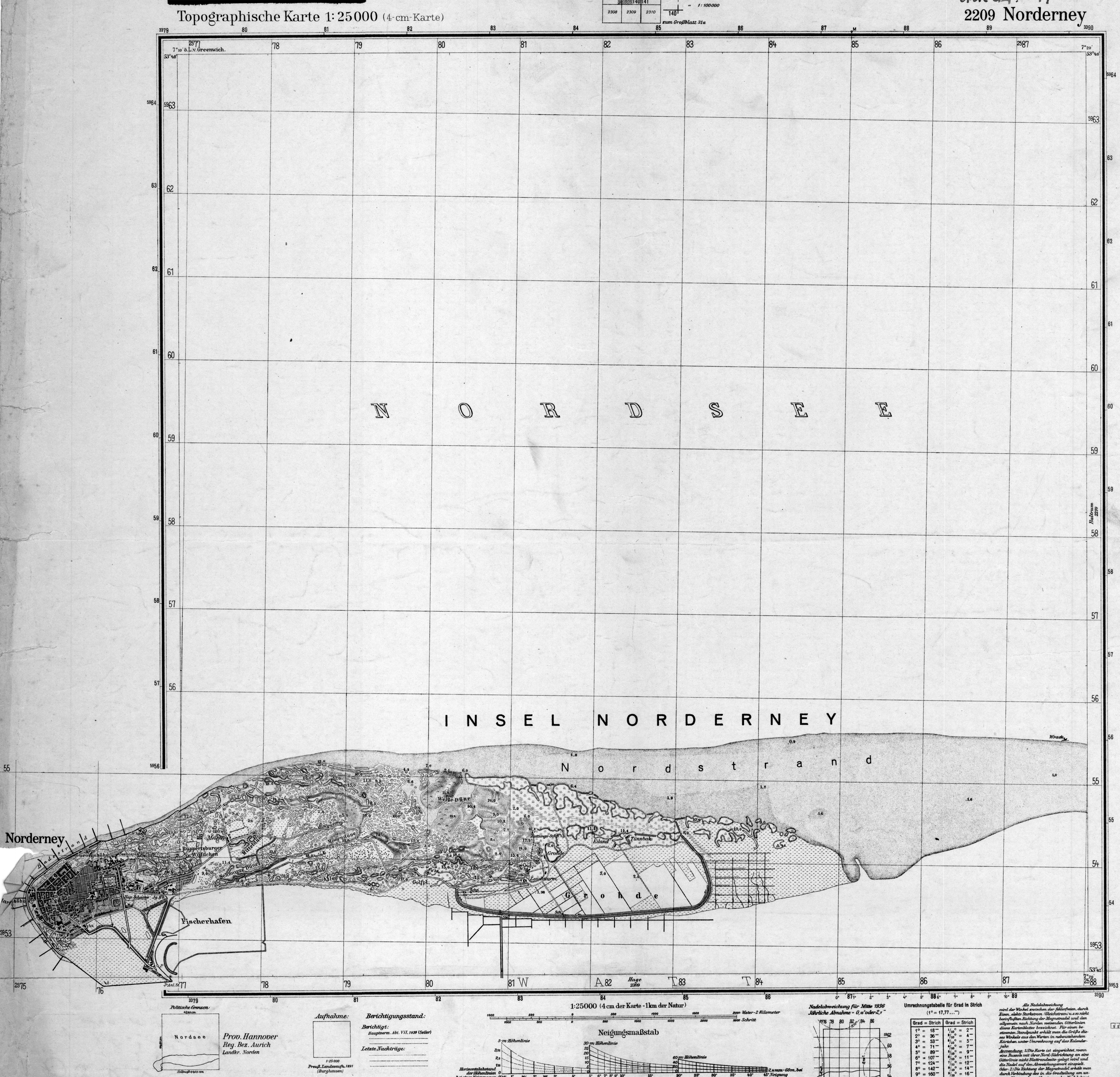
Individual evidence
- ↑ a b State Office for Statistics Lower Saxony, LSN-Online regional database, Table 12411: Update of the population, as of December 31, 2019 ( help on this ).
- ↑ Van Harten welcomed or “Hey!” As we are up here on the island. (No longer available online.) City of Norderney, archived from the original on February 23, 2014 ; Retrieved September 11, 2010 .
- ↑ Low German Week opened . In: Norderneyer morning . No. 251 , September 7, 2009, p. 1 ( norderneyer-morgen.de [PDF; 920 kB ; accessed on March 22, 2013]).
- ↑ Nörderneei loses an "i". Fischpresse UG, September 21, 2012, accessed on January 7, 2017 .
- ^ Island and North Sea Spa Norderney - a journey through history. City of Norderney, accessed October 5, 2012 .
- ↑ a b c d e Number of guests on Norderney after the introduction of the NorderneyCard . In: Norderneyer bath newspaper . April 14, 2007 (With the introduction of the NorderneyCard, the Staatsbad Norderney GmbH has a statistical background system which outputs concrete actual figures for guest arrivals. So far, only the actual visitor's tax income could be compared to previous years Due to the empirical comparability of the statistical data, the guest and overnight stays were compiled annually. Although this has shown a comparable development over a longer period of time, it has also led to inaccuracies and deviations. The facts ascertained that the number of guest arrivals was considerable In contrast to this, the number of overnight stays is well below the previous assumptions and has never exceeded the limit of three million overnight stays according to the new findings ng all providers with less than nine beds falsifies the statistics. In the North Sea, this unrecorded proportion is more than 40% on average. The following list shows the corrected number of guests and overnight stays determined using the NorderneyCard . 1997: 266,513 guests / 2,891,668 overnight stays; 1998: 265,803 / 2,780,299; 1999: 276,709 / 2,786,455; 2000: 295,232 / 2,857,848; 2001: 321,372 / 2,985,546; 2002: 324,164 / 2,885,058; 2003: 348,196 / 2,963,146; 2004: 362,072 / 2,940,023; 2005: 378,223 / 2,923,663; 2006: 405,284 / 2,978,840; 2007: 426,533 / 3,059,268; 2008: 432,018 / 3,088,726; 2009: 451,006 / 3,167,551; 2010: 446.392 / 3.153.301).
- ↑ a b c Verena Leidig: exceeded 6 million euros for the first time . Health resort administration balance sheet: Norderney gained a good 2.5 percent in overnight stays in 2009. The number of day visitors also increased. In: Norderneyer morning . No. 19 , 23 January 2010, p. 3 ( norderneyer-morgen.de [PDF; accessed on March 22, 2013]).
- ↑ a b c NLS-Online: Table K7350001 Accommodation for tourists - Open accommodation establishments with at least 10 beds. State Office for Statistics and Communication Technology Lower Saxony (LSKN), accessed on April 8, 2020 .
- ↑ a b NLS-Online: Table K7360001 Tourist accommodation - Open accommodation establishments with at least 10 beds and open campsites with at least 10 parking spaces. State Office for Statistics and Communication Technology Lower Saxony (LSKN), accessed on April 8, 2020 .
- ↑ NLS-Online table Z0010001 Floor area according to the type of planned use . State Office for Statistics and Communication Technology Lower Saxony (LSKN), January 1, 2005, accessed on January 17, 2009 .
- ^ National Park Administration of Lower Saxony Wadden Sea (Ed.): Regional folder Norderney . 11th edition. Wilhelmshaven 2016, p. 2 ( nationalpark-wattenmeer.de [PDF; 1.6 MB ; accessed on April 17, 2016]).
- ^ A b Johannes Walter: The East Frisian Islands, seminar on regional geography of Northwest Germany. (PDF; 3.93 MB) University of Stuttgart / Institute for Geography, 2001, p. 9 ff. , Accessed on January 17, 2009 .
- ^ Hansjörg Streif : The East Frisian coastal area. North Sea, islands, mud flats and marshes . 2nd Edition. Collection of geological guides, volume 57 . Borntraeger Verlagbuchhandlung, Berlin / Stuttgart 1990, ISBN 3-443-15051-9 .
- ↑ a b c d Torsten Schlurmann: Page no longer available , search in web archives: excursion reprint for the Great Hydraulic Excursion 2007. (PDF; 6.5 MB), pp. 23-27.
- ^ A b Lower Saxony State Agency for Water Management, Coastal Protection and Nature Protection [NLWKN] (Ed.): Coastal protection for the island of Baltrum - redesign of the revetment on the north beach . May 18, 2011 ( baltrum-online.de [PDF; 3.0 MB ; accessed on October 5, 2012]).
- ↑ a b c d East Frisia . In: MERIAN - The monthly magazine of cities and landscapes . No. 4 . Hoffmann and Kampe Verlag, Hamburg 1988, p. 41 ff .
- ↑ Lower Saxony map - city map 1: 25,000 for exact planning. Authority for Geoinformation, Rural Development and Real Estate (GLL) of the federal state of Lower Saxony, accessed on January 17, 2009 .
- ↑ a b c d e f Experience nature in Lower Saxony - national natural landscapes. Lower Saxony Ministry for the Environment and Climate Protection, accessed on March 13, 2009 .
- ↑ Drinking water supply for the island of Norderney. (PDF) Hans-Helmut Barty, accessed on April 15, 2016 .
- ↑ Storm surge on the North Sea, swell of 8.50 meters. n-tv Nachrichtenfernsehen GmbH, November 8, 2007, accessed on February 28, 2010 .
- ↑ Climate data - mean values 2015-2020. Weather-online, accessed February 3, 2020 .
- ↑ Decade records (maximum and minimum temperature values) in German cities. German Weather Service (DWD), accessed on January 3, 2018 .
- ↑ Remote water level data transmission online level. (PDF; 64 kB) Federal Ministry of Transport, Building and Urban Development, Federal Waterways and Shipping Administration - Northwest Waterways and Shipping Directorate, May 2004, accessed on February 18, 2009 .
- ↑ Mean and extreme ice parameters for the period 1961 to 2000. Federal Maritime and Hydrographic Agency (BSH), accessed on January 17, 2009 .
- ↑ Markus Kottek: Effective climate classification according to Wladimir Peter Köppen. (GIF; 143 kB) University of Veterinary Medicine, Vienna, 2006, accessed on January 17, 2009 .
- ↑ The climate in Norderney. Weather-online, accessed February 3, 2020 .
- ^ Indices data. In: www.ecad.eu. Retrieved January 17, 2019 .
- ↑ a b The flora and fauna of the East Frisian Islands. Carl von Ossietzky University; Faculty V, Institute for Biology and Environmental Sciences, Oldenburg, February 4, 2010, accessed on August 22, 2010 .
- ↑ a b c d Hermann Messerschmidt: Norderney Illustrated Guide with city map and island map . 9th edition. F. Coppenrath Verlag, Münster 1983, ISBN 3-920192-03-6 , p. 46 ff .
- ↑ a b c page no longer available , search in web archives: vegetation mapping of the terrestrial areas of the Lower Saxony Wadden Sea National Park - detailed map TMAP vegetation types sheet 04: Norderney-West (PDF; 4.1 MB).
- ^ Karl Lüders, Günter Luck: Small coastal encyclopedia: Nature and technology on the German North Sea coast . August Lax Verlagbuchhandlung, Hildesheim 1976.
- ↑ a b c d e f g h i j k l Richard Pott: The North Sea. A natural and cultural history . Norderney - A model island for environmentally friendly tourism. CH Beck, Munich 2003, ISBN 3-406-51030-2 , chapter 15, p. 243 ff .
- ↑ a b Manfred Bätje and Ottmar Heinze: Norderney. A picture journey. Seaside resort with tradition . Ellert & Richter Verlag, Hamburg 2004, ISBN 3-8319-0147-3 , p. 26 .
- ↑ Moor duck on the south beach polder . In: Norderneyer morning . No. 72 , January 27, 2009, p. 2 ( norderneyer-morgen.de [PDF; 604 kB ; accessed on March 22, 2013]).
- ↑ Jakob Vicari: Escape to the island - the last stable population of the hen harrier breeds in the dunes of Norderney. Retrieved February 14, 2009 .
- ^ A b Hermann Messerschmidt: Norderney Illustrated Guide with city map and island map . 9th edition. F. Coppenrath Verlag, Münster 1983, ISBN 3-920192-03-6 , p. 61-71 .
- ↑ World natural heritage recognized . In: Norderneyer morning . No. 190 , June 27, 2009, p. 1 ( norderneyer-morgen.de [PDF; 1.3 MB ; accessed on March 22, 2013]).
- ^ National Park House on Norderney. National Park House Norderney, Jürgen Rahmel, accessed on January 17, 2009 .
- ↑ a b Planet Path Norderney. (PDF; 1 MB) Lower Saxony Ministry for the Environment and Climate Protection, accessed on June 1, 2010 .
- ↑ Barkenpad Norderney. (PDF; 1.03 MB) Lower Saxony Ministry for the Environment and Climate Protection, accessed on June 1, 2010 .
- ↑ The hiking trails in detail. (No longer available online.) Staatsbad Norderney GmbH, archived from the original on January 28, 2013 ; Retrieved October 5, 2012 . Info: The archive link was inserted automatically and has not yet been checked. Please check the original and archive link according to the instructions and then remove this notice.
- ^ National Park House Norderney. National Park Administration Nds. Wadden Sea, July 25, 2010, accessed October 5, 2012 .
- ↑ a b Map with the boundaries of the national park and the three different protection zones. National Park Administration Nds. Wadden Sea, accessed October 5, 2012 .
- ^ History. (No longer available online.) Golfclub Norderney eV, archived from the original on October 25, 2012 ; Retrieved February 26, 2012 . Info: The archive link was inserted automatically and has not yet been checked. Please check the original and archive link according to the instructions and then remove this notice.
- ^ Golf course - Germany's only links course. (No longer available online.) Golfclub Norderney eV, archived from the original on October 24, 2012 ; Retrieved February 26, 2012 . Info: The archive link was inserted automatically and has not yet been checked. Please check the original and archive link according to the instructions and then remove this notice.
- ^ Rudi Meyer: Norderney golf course: District rejects expansion. ZGO Zeitungsgruppe Ostfriesland GmbH, February 23, 2012, accessed on January 30, 2014 .
- ↑ Verena Leidig: Species decline accelerated . In: Norderneyer morning . No. 20 , November 24, 2008, p. 1 ( norderneyer-morgen.de [PDF; 1000 kB ; accessed on March 22, 2013]).
- ↑ Dirk Kähler: Citizens have decided . In: Norderneyer morning . No. 223 , October 15, 2011, p. 1 ( norderneyer-morgen.de [PDF; 1.3 MB ; accessed on March 22, 2013]).
- ^ Rudi Meyer: Norderney golf course: District rejects expansion. ZGO newspaper group Ostfriesland, February 13, 2012, accessed on February 26, 2012 .
- ↑ Norderney salt marsh educational trail. (PDF; 1023 kB) Lower Saxony Ministry for the Environment and Climate Protection, accessed on March 13, 2009 .
- ↑ Morphological analyzes for island protection. Lower Saxony State Agency for Water Management, Coastal Protection and Nature Conservation, accessed on January 7, 2011 .
- ↑ Cornelius Meyer, Hans-Joachim Stephan: special investigations for preliminary work on island protection East Frisian Islands, morphological development in the catchment area of the Norderneyer Seegat . Ed .: Lower Saxony State Office for Ecology - Coastal Research Center -. Norderney July 2000 ( nlwkn.niedersachsen.de [PDF; 16.6 MB ; accessed on March 22, 2013]).
- ↑ From Ees, Gats and Baljen. Lower Saxony Wadden Sea National Park Administration, April 1, 2007, accessed on October 5, 2012 .
- ^ Karl-Ernst Behre and Hajo van Lengen : Ostfriesland. History and shape of a cultural landscape . Aurich 1995, ISBN 3-925365-85-0 , p. 173 .
- ↑ When the flood tore through Wangerooge. In: NDR.de - Culture - History - Chronology. November 30, 2011, accessed March 5, 2017 .
- ↑ Norderney: Wulff hands over the revetment to its destination. Lower Saxony State Agency for Water Management, Coastal Protection and Nature Conservation (NLWKN), accessed on April 17, 2016 .
- ↑ Lower Saxony State Agency for Water Management, Coastal Protection and Nature Conservation (NLWKN): Information brochure available at the construction site of the coastal protection measure : Securing the western head of the island of Norderney by washing up the beach. (No longer available online.) Lower Saxony State Agency for Water Management, Coastal Protection and Nature Conservation (NLWKN), archived from the original on April 19, 2016 ; Retrieved April 19, 2016 .
- ^ Island protection works between Viktoriastraße and Westdeich. City of Norderney, March 23, 2009, accessed January 6, 2011 .
- ↑ NLWKN: No concrete plans for coastal protection systems . In: Norderneyer morning . No. 111 , March 21, 2009, p. 2 ( norderneyer-morgen.de [PDF; 1.1 MB ; accessed on March 22, 2013]).
- ↑ Not sealed . In: Norderneyer morning . No. 140 , April 27, 2009, p. 1 ( norderneyer-morgen.de [PDF; 839 kB ; accessed on March 22, 2013]).
- ↑ It is decided to wash up the beach . In: Norderneyer Rundschau . No. 8 , March 28, 2007, p. 1 .
- ↑ Newsletter May 2007 / Norderney Coastal Protection. (No longer available online.) Lower Saxony Ministry for the Environment, Energy and Climate Protection, May 2, 2007, archived from the original on April 17, 2016 ; Retrieved April 17, 2016 .
- ↑ Revetment renovation Baltrum - the listed historic pile protection structure from the 1930s was repaired in 2008. Lower Saxony State Agency for Water Management, Coastal Protection and Nature Conservation (NLWKN), January 15, 2009, accessed on March 25, 2009 .
- ^ Lower Saxony State Office for Water Management, Coastal Protection and Nature Conservation (NLWKN): Information board at the construction site of the dike
- ↑ General plan for coastal protection - Lower Saxony . East Frisian Islands. In: Lower Saxony State Agency for Water Management, Coastal and Nature Conservation [NLWKN] (Ed.): Coastal protection . tape 2 ( nlwkn.niedersachsen.de [PDF; 4.0 MB ; accessed on January 23, 2016]).
- ↑ a b c NLS-Online: Table K1000014 “Population update”. State Office for Statistics and Communication Technology Lower Saxony (LSKN), accessed on January 17, 2009 .
- ↑ a b Brockhaus' Kleines Konversations-Lexikon . 5th edition. tape 2 . Bibliographisches Institut & FA Brockhaus, Leipzig 1911, p. 283 .
- ↑ State Office for Statistics and Communication Technology Lower Saxony (LSKN): Municipalities at a glance: key data for the unitary and integrated municipalities of the state . Retrieved January 17, 2009 .
- ^ Herder's Conversations Lexicon . tape 4 . Herder publishing house, Freiburg im Breisgau 1856, p. 353 .
- ↑ Meyers Konversationslexikon . 4th edition. tape 12 . Bibliographisches Institut & FA Brockhaus, Mannheim 1885, p. 218-219 .
- ^ Meyer's Large Conversational Lexicon . tape 14 . Bibliographisches Institut & FA Brockhaus, Leipzig 1908, p. 758 .
- ↑ NLS-Online: Table M2021011 1987 census in Lower Saxony . State Office for Statistics and Communication Technology Lower Saxony (LSKN), accessed on February 12, 2009 .
- ↑ East Frisia and its islands . In: MERIAN - The monthly magazine of cities and landscapes . No. 3 . Hoffmann and Kampe Verlag, Hamburg 1972, p. 21 .
- ^ Karl-Ernst Behre, Hajo van Lengen: Ostfriesland. History and shape of a cultural landscape . East Frisian Landscape, Aurich 1995, ISBN 3-925365-85-0 , p. 28 .
- ↑ a b c Settlement with a fisherman's house or Driev-Huus? In: Norderneyer Kurier . January 9, 2009, p. 4 .
- ^ A b Gottfried Kiesow: Architectural Guide East Friesland . German Foundation for Monument Protection - Monuments Publications, Bonn 2009, ISBN 978-3-86795-021-3 , p. 364 .
- ↑ a b c d e f g h i j Information brochure from the Norderney spa administration
- ↑ Norderney. In: Johann Heinrich Zedler : Large complete universal lexicon of all sciences and arts . Volume 24, Leipzig 1740, column 1274.
- ^ Adolph Leopold Richter: The seaside resorts on Norderney, Wangeroog and Helgoland, together with topographical and geognostic remarks on these islands in the North Sea . Verlag von Theod. Christian. Friedr. Enstin, Berlin 1833, p. 26 ( full text in Google Book Search).
- ↑ State Office for Statistics and Communication Technology Lower Saxony (LSKN): Natural population movement, migrations in Lower Saxony municipalities. (No longer available online.) Archived from the original on March 23, 2010 ; Retrieved January 17, 2009 . Info: The archive link was inserted automatically and has not yet been checked. Please check the original and archive link according to the instructions and then remove this notice.
- ↑ Guide to the municipality - municipal data. Bertelsmann Stiftung , accessed April 15, 2016 .
- ^ Bertelsmann Stiftung: Guide to Commune - Communal Data. Retrieved April 15, 2016 .
- ↑ KomSIS network of the districts and independent cities in Lower Saxony: Age structure Norderney. Retrieved April 17, 2016 .
- ^ Bertelsmann Stiftung: Guide to the Commune - Demographic Change Norderney. Retrieved April 17, 2016 .
- ↑ State Office for Statistics and Communication Technology Lower Saxony (LSKN): Forecast of population development. (No longer available online.) Archived from the original on December 17, 2009 ; Retrieved January 17, 2009 . Info: The archive link was inserted automatically and has not yet been checked. Please check the original and archive link according to the instructions and then remove this notice.
- ↑ a b Population by age and gender. Federal and State Statistical Offices, accessed on June 8, 2013 .
- ↑ Population by age. Federal and State Statistical Offices, accessed on June 8, 2013 .
- ↑ Apartments in buildings with living space according to the area of the apartment in m². Federal and State Statistical Offices, accessed on June 8, 2013 .
- ↑ Building and apartment key figures in a regional comparison. Federal and State Statistical Offices, accessed on June 9, 2013 .
- ↑ Apartments in buildings with living space by type of use. Federal and State Statistical Offices, accessed on June 8, 2013 .
- ^ A b c Adolf Bach: German naming . The German place names. University Press Carl Winter, Heidelberg 1952, p. 568 .
- ↑ Carl Gerhard Reins: The island of Nordernei after its previous and its present condition . Ms. Sulemann, Hannover 1853, p. 2 ( online edition ).
- ↑ Volker Scheut angle: history of the North Sea resort of Norderney in 19/20. Century . GRIN Verlag, Oldenburg 2007, ISBN 3-638-67044-9 , 2. Norderney: From the beginnings to the 19th century, p. 3 .
- ↑ a b c Arend Remmers : From Aaltukerei to Zwischenmooren. The settlement names between Dollart and Jade . Verlag Schuster, Leer 2004, ISBN 3-7963-0359-5 , p. 165 .
- ^ Karl Leiner: Panorama district north. Photos. Coat of arms. People. Notes . Self-published district of Norden, Norden 1972, p. 317 .
- ↑ Theatrum Europaeum, Vol. 02 (1646). Augsburg University Library, accessed on September 29, 2010 .
- ↑ Nicolas Sanson: Le Cercle de la Basse Saxe (The Lower Saxony District), map of Northern Germany from 1692, Norderney City Archives
- ↑ a b Information brochure from the Juist spa administration
- ^ Günther Möhlmann: History of the city and the seaside resort of Norderney . Heimatverein Norderney, Norderney 1964.
- ↑ Udo Benzenhöfer: On the social history of psychiatry in the Kingdom of Hanover (1814–1866) . Verlag Mainz, Aachen 1992, ISBN 3-925714-55-3 , p. 14 .
- ^ Karl-Ernst Behre, Hajo van Lengen: Ostfriesland. History and shape of a cultural landscape . East Frisian Landscape, Aurich 1995, ISBN 3-925365-85-0 , p. 168 .
- ^ Biographical lexicon for East Frisia: Friedrich Wilhelm von Halem. (PDF) Ostfriesische Landschaft - corporation under public law, accessed on January 17, 2009 .
- ↑ Soltausche Buchdruckerei, Lower Saxon State Norderney (ed.): Bathing courier Norderney . 200 years of Norderney seaside resort. Soltausche Buchdruckerei, Norderney 1997, p. 2 .
- ↑ Norderney - Chronicle of an island (The island windmill). Retrieved November 18, 2019 .
- ^ Karl-Ernst Behre, Hajo van Lengen: Ostfriesland. History and shape of a cultural landscape . East Frisian Landscape, Aurich 1995, ISBN 3-925365-85-0 , p. 174 .
- ↑ Hans-Helmut Barty: So far recorded street names of the island Norderney . Norderney 2005 ( Document [PDF; 12 kB ; accessed on February 5, 2019]).
- ^ Hermann Messerschmidt: Norderney Illustrated Guide with city map and island map . 9th edition. F. Coppenrath Verlag, Münster 1983, ISBN 3-920192-03-6 , p. 19 .
- ↑ The field names collection of the East Frisian landscape. Authority for Geoinformation, Land Development and Real Estate Aurich (GLL Aurich), accessed on October 5, 2012 .
- ↑ Bonno Eberhart: Land speculation began in 1872 . Series: And they still exist, the original Norderneyer (part two). In: Norderneyer Kurier . September 8, 2017, Local, p. 7 .
- ↑ a b Prussia's splendor and glory spills over . In: Norderneyer Kurier . February 13, 2009, p. 4 .
- ^ J. Voß: The North Sea island of Spiekeroog and the seaside resort there . Prätorius and Seyde, Aurich and Leer 1850, p. 6 ( limited preview in Google Book Search [accessed August 16, 2017]).
- ^ Klaus Beneke: Report on the opening of the Friedrich Wilhelm Beneke room. (PDF; 9.4 MB) Christian-Albrechts-Universität zu Kiel, October 18, 2005, pp. 25–26 , accessed on January 17, 2009 .
- ^ Biographical lexicon for East Frisia: Jann Jannsen Berghaus. (PDF) Ostfriesische Landschaft - corporation under public law, accessed on January 17, 2009 . (PDF).
- ↑ Auguste Rulffes: Hans Trimborn. A life in pictures . Soltau-Kurier, Norden 1993, ISBN 3-922365-06-X , p. 33 .
- ↑ Comical mountain at the peak. Hans Vollmer, April 6, 2010, accessed April 6, 2010 .
- ↑ Soltausche Buchdruckerei, Lower Saxon State Norderney (ed.): Bathing courier Norderney . Reports information event highlights. No. 49 . Soltausche Buchdruckerei, Norderney 1998, History of the Norderneyer street names, p. 12 .
- ↑ Hans-Helmut Barty: Norderney, Chronik einer Insel (1959). Retrieved December 15, 2012 .
- ↑ Dirk Kähler: B-plan in the committee . In: Norderneyer morning . No. 28 , February 11, 2010, p. 1 ( norderneyer-morgen.de [PDF; 911 kB ; accessed on March 22, 2013]).
- ↑ Only spa concerts are not enough , report on the dissolution of the Lower Saxony baths company. In: ReformZeit No. 3. Lower Saxony Ministry of the Interior and Sport, October 1999, accessed on January 17, 2009 .
- ↑ Norderney again recognized as a North Sea spa . In: Norderneyer morning . No. 40 , February 25, 2010, p. 2 ( norderneyer-morgen.de [PDF; 1000 kB ; accessed on March 22, 2013]).
- ^ Daniel Noglik: Norderneyerin infected with coronavirus. ZGO newspaper group Ostfriesland, March 11, 2020, accessed on March 18, 2020 .
- ^ Press office of the Lower Saxony state government: Access to the islands for tourists prevented. Retrieved March 18, 2020 .
- ↑ The deadline now ends on Sunday . In: Norderneyer morning . No. 57 , March 20, 2020, p. 3 ( norderneyer-morgen.de [PDF; 1.4 MB ; accessed on March 20, 2020]).
- ^ City of Norderney: Coronavirus - current information. Retrieved March 18, 2020 .
- ^ Aurich district: number of corona infections increased to 22. Retrieved March 20, 2020 .
- ↑ Coronavirus . City of Norderney. May 1, 2020. Accessed May 13, 2020.
- ↑ Norderney - Germany trip. (No longer available online.) BerlinOnline city portal, November 23, 2009, archived from the original on May 26, 2015 ; Retrieved November 27, 2009 . Info: The archive link was inserted automatically and has not yet been checked. Please check the original and archive link according to the instructions and then remove this notice.
- ^ Münstersche Zeitung of March 28, 1990
- ↑ Felix Nussbaum. G.-E.-Lessing-Gymnasium Döbeln, accessed on September 10, 2012 .
- ^ Felix Nussbaum catalog raisonné. Felix Nussbaum Foundation, accessed September 10, 2012 .
- ^ Heinrich Heine: The North Sea - Third Department. 1826, Retrieved January 17, 2009 .
- ^ Association news 2009. German life-saving society, Lower Saxony regional association - District of East Friesland - local group Norderney e. V., May 14, 2010, accessed July 5, 2011 .
- ↑ Marcus Jauer: Search message: Where is Horst Köhler? FAZ Electronic Media, July 27, 2010, accessed on July 29, 2010 .
- ^ Local elections on Norderney. Hans-Helmut Barty, accessed on December 31, 2016 .
- ^ Lower Saxony Municipal Constitutional Law (NKomVG) in the version of December 17, 2010; §46 - Number of MPs. Accessed December 31, 2016 .
- ^ Council of the city of Norderney. City of Norderney, accessed December 31, 2016 .
- ^ City of Norderney (Ed.): Local elections 2016 - distribution of votes . ( stadt-norderney.de [PDF; 69 kB ; accessed on December 31, 2016]).
- ↑ Verena Leidig: Norderney's mayor gives up his office. ZGO newspaper group Ostfriesland, June 28, 2011, accessed on December 31, 2016 .
- ↑ Announcement of the election results of the mayoral election. City of Norderney, accessed December 31, 2016 .
- ^ Frank Ulrichs: Bundestag election 2013. City of Norderney, September 2, 2013, accessed on December 31, 2016 .
- ↑ a b Bundestag election 2017 / election evening (ES). Aurich district, September 24, 2017, accessed on September 24, 2017 .
- ^ Nordwest-Zeitung: Bundestag election: These members represent our region . In: NWZonline . ( nwzonline.de [accessed September 29, 2017]).
- ↑ Klemens Stadler: German coat of arms . The municipal coats of arms of the federal states of Lower Saxony and Schleswig-Holstein. tape 5 . Bremen 1970, p. 62 .
- ^ German coat of arms (municipality coat of arms / district coat of arms): Norderney. Ralf Hartemink, accessed January 17, 2009 .
- ^ The Bremen Town Hall. Free Hanseatic City of Bremen, accessed on February 22, 2012 .
- ↑ Dirk Kähler: Chapter: New building or renovation? In: Norderneyer morning . No. 232 , October 14, 2015, p. 1 and 3 ( nomo-norderney.de [PDF; 2.4 MB ; accessed on October 15, 2015]).
- ↑ Norderneyer morning of October 10, 2017: Cape is complete again . Retrieved October 25, 2017.
- ↑ Norderney lighthouse. Federal Waterways and Shipping Administration (WSV) - WSA Emden, accessed on January 17, 2009 .
- ^ Sights on Norderney: The lighthouse. RID Travel Information Service, accessed January 17, 2009 .
- ↑ Norderney beacon. The Lighthouse Atlas, accessed January 17, 2009 .
- ↑ Tide level: Norderney-Riffgat. Lower Saxony State Agency for Water Management, Coastal Protection and Nature Conservation (NLWKN), accessed on April 19, 2016 .
- ↑ Eckart Roloff , Karin Henke-Wendt: Visit your doctor or pharmacist. A tour through Germany's museums for medicine and pharmacy . tape 1 : Northern Germany . S. Hirzel, Stuttgart 2015, ISBN 978-3-7776-2510-2 , An island, a poet and the sea - that helps a lot. (The North Sea Spa Museum), p. 91-93 .
- ↑ History on 650 square meters . In: Norderneyer morning . No. 236 , October 19, 2015, p. 1 f . ( nomo-norderney.de [PDF; 1.9 MB ; accessed on October 19, 2015]).
- ↑ Norderneyer Fischerhausmuseum. Institute for Museum Research of the National Museums in Berlin, accessed on May 28, 2013 .
- ^ Station: Norderney - DGzRS Die Seenotretter. German Society for the Rescue of Shipwrecked People, accessed on January 14, 2018 .
- ↑ William Esmann: The lifeboats DGzRS from 1865 to 2004 . Verlag HM Hauschild, Bremen 2004, ISBN 3-89757-233-8 , p. 106 .
- ↑ Norderney. (No longer available online.) German Society for Rescue of Shipwrecked People (DGzRS), formerly in the original ; Retrieved June 19, 2010 . ( Page no longer available , search in web archives ) Info: The link was automatically marked as defective. Please check the link according to the instructions and then remove this notice.
- ↑ a b William Esmann: The lifeboats DGzRS from 1865 to 2004 . Verlag HM Hauschild, Bremen 2004, ISBN 3-89757-233-8 , p. 16 .
- ↑ William Esmann: The lifeboats DGzRS from 1865 to 2004 . Verlag HM Hauschild, Bremen 2004, ISBN 3-89757-233-8 , p. 45 .
- ↑ William Esmann: The lifeboats DGzRS from 1865 to 2004 . Verlag HM Hauschild, Bremen 2004, ISBN 3-89757-233-8 , p. 17 .
- ^ Heinz Busching and Martin Stromann: Norderney - Panorama of a North Sea island . Soltau-Kurier-Norden Printing and Publishing, Norden 2004, ISBN 3-928327-67-4 .
- ^ A b Gottfried Kiesow: Architectural Guide East Friesland . German Foundation for Monument Protection - Monuments Publications, Bonn 2009, ISBN 978-3-86795-021-3 , p. 369 .
- ↑ Gottfried Kiesow: Architectural Guide Ostfriesland . German Foundation for Monument Protection - Monuments Publications, Bonn 2009, ISBN 978-3-86795-021-3 , p. 366 .
- ↑ Marienhöhe. (No longer available online.) City of Norderney, archived from the original on February 25, 2007 ; Retrieved January 17, 2009 .
- ↑ a b Sights. Jann Ennen, accessed January 17, 2009 .
- ↑ Gottfried Kiesow: Architectural Guide Ostfriesland . German Foundation for Monument Protection - Monuments Publications, Bonn 2009, ISBN 978-3-86795-021-3 , p. 367 .
- ↑ Verena Leidig: Post leaves post . In: Hey! Norderney . 04/08 winter 2008 / spring 2009, 2008, p. 27 ff .
- ^ House of the island: problem of the large hall . In: Norderneyer morning . No. 69 , January 23, 2009, p. 3 ( norderneyer-morgen.de [PDF; 1.5 MB ; accessed on March 22, 2013]).
- ↑ House of the Island: The demolition is imminent . In: Norderneyer morning . No. 263 , November 20, 2019, p. 1 ( norderneyer-morgen.de [PDF; 2.1 MB ; accessed on August 7, 2020]).
- ↑ House of the Island: The work is on schedule . In: Norderneyer morning . No. 44 , March 5, 2020, p. 2 ( norderneyer-morgen.de [PDF; 2.2 MB ; accessed on July 1, 2020]).
- ^ A b Hermann Messerschmidt: Norderney Illustrated Guide with city map and island map . 9th edition. F. Coppenrath Verlag, Münster 1983, ISBN 3-920192-03-6 , p. 23 .
-
↑ Origin of the donated stones: Aachen, Altenburg, Altona, Aschaffenburg, Baden-Baden, Bad Ems, Bad Kissingen, Bad Reichenhall, Barmen, Beuthen / Silesia, Berlin, Bonn, Brandenburg, Bremen, Braunschweig, Hohenzollern Castle / Swabia, Chemnitz, Coburg, Dresden, Dortmund, Eisleben, Elberfeld, Elbing / West Prussia, Erfurt, Erlangen, Essen, Fehrbellin, Flensburg, Frankfurt am Main, Freiburg im Breisgau, Freiberg / Saxony, Fürstenstein / Silesia, Gera, Görlitz, Hagen, Halle, Hanover, Hildesheim, Hof, Kassel, Kaiserslautern, Kempten, Kiel, Kitzingen, Cologne, Königsberg / East Prussia, Krefeld, Leipzig, Lübeck, Mannheim, Mansfeld, Mühlhausen / Thuringia, Munich, Nuremberg, Offenbach, Osnabrück, Pforzheim, Plauen, Posen, Rostock, County of Ruppin / Brandenburg , Schweinfurt, Spandau, Strasbourg / Alsace, Ulm, Weimar, Wetter / Ruhr, Wildemann / Harz, Wiesbaden, Würzburg, Zwickau and 1956 Lüdinghausen.The
heaviest stones, each weighing five tons, come from Aschaffenburg, Baden-Baden and Leipzig. The granite block from Berlin weighs six tons. - ↑ Worth seeing. Meyer Inselhus, accessed April 15, 2016 .
- ↑ Gottfried Kiesow: Architectural Guide Ostfriesland . German Foundation for Monument Protection - Monuments Publications, Bonn 2009, ISBN 978-3-86795-021-3 , p. 370 .
- ↑ German Society for Milling Knowledge and Maintenance of Mills [DGM] e. V. (Ed.): Mill locations in Lower Saxony-Bremen . East Frisia district. S. 5 ( muehlen-dgm-ev.de [PDF; 324 kB ; accessed on March 22, 2013]).
- ↑ A little mill knowledge. (No longer available online.) Restaurant Zur Mühle, archived from the original on April 15, 2016 ; accessed on April 14, 2016 . Info: The archive link was inserted automatically and has not yet been checked. Please check the original and archive link according to the instructions and then remove this notice.
- ↑ Dirk Kähler: hey! Norderney . Seasonal magazine for Norderneyer Morgen. The mill is 150 years old, S. 4th ff .
- ↑ Hans-Helmut Barty: Norderney, Chronik einer Insel (2010). Retrieved April 15, 2016 .
- ↑ 600 kilos of copper for the dome . In: Norderneyer bath newspaper . October 16, 2011, p. 1 ( norderney-chronik.de [PDF; 1.3 MB ; accessed on April 15, 2016]).
- ↑ Napoleon Hill . (No longer available online.) City of Norderney, archived from the original on February 25, 2007 ; Retrieved January 17, 2009 .
- ↑ Heimatverein Norderney e. V .: Klootschießen und Boßeln ( Memento from December 31, 2011 in the Internet Archive ), accessed on April 14, 2016.
- ^ TuS Norderney e. V. ( Memento from March 2, 2012 in the Internet Archive )
- ↑ Football: Norderneyer are still looking for reinforcement . In: Norderneyer morning . No. 291 , June 30, 2009, p. 2 ( norderneyer-morgen.de [PDF; 1.1 MB ; accessed on March 22, 2013]).
- ↑ Before the game in the bath house . In: Norderneyer morning . No. 192 , October 24, 2009, p. 4 ( norderneyer-morgen.de [PDF; 1.3 MB ; accessed on March 22, 2013]).
- ↑ Jörg Hasenfratz: “TuSsis” butter TSV “Milchbubis”. TuS Norderney e. V., May 4, 2010, accessed June 19, 2010 .
- ↑ Football: TuS men are already getting promoted . In: Norderneyer morning . No. 144 , June 2, 2010, p. 1 ( norderneyer-morgen.de [PDF; 1000 kB ; accessed on March 22, 2013]).
- ^ Günther Czempiel: Norderney expects professionals from Werder Bremen. ZGO newspaper group Ostfriesland, Norderneyer Badezeitung - Verlagshaus Norderney, July 3, 2009, accessed on October 21, 2012 .
- ↑ Gabriele Boschbach: Krefeld trains from Monday on the beach. ZGO newspaper group Ostfriesland, Norderneyer Badezeitung - Verlagshaus Norderney, January 8, 2010, accessed on October 21, 2012 .
- ↑ See you again on the island? In: Norderneyer morning . No. 98 , May 7, 2010, p. 1 ( norderneyer-morgen.de [PDF; 1.6 MB ; accessed on March 22, 2013]).
- ↑ First division club Eintracht Frankfurt visits Norderney. (No longer available online.) City of Norderney, archived from the original on August 8, 2014 ; accessed on August 2, 2014 . Info: The archive link was inserted automatically and has not yet been checked. Please check the original and archive link according to the instructions and then remove this notice.
- ↑ International Film Festival Emden-Norderney. Volkshochschule Emden e. V., accessed January 17, 2009 .
- ↑ Helen Drieling: The rush of visitors caused a "ferry record". Ostfriesen-Zeitung; ZGO newspaper group Ostfriesland, May 13, 2008, accessed on October 30, 2011 .
- ↑ Henning Eberhardt: Shoes off and into pleasure . In: Norderneyer morning . No. 120 , June 4, 2010, p. 2 ( norderneyer-morgen.de [PDF; 1,2 MB ; accessed on March 22, 2013]).
- ^ 8. Kempa Beachhandball Tournament Norderney 2013. In: NoMo-Norderney. Fischpresse, Dirk Kähler and Anja Pape, June 7, 2013, accessed on February 11, 2016 .
- ↑ Verena Leidig: Trembling is the most exhausting . In: Norderneyer morning . No. 134 , June 21, 2010, p. 1 ( norderneyer-morgen.de [PDF; 1.5 MB ; accessed on March 22, 2013]).
- ↑ 17. Island jumping. (No longer available online.) KEM - König Event Marketing, archived from the original on April 29, 2010 ; Retrieved June 21, 2010 . Info: The archive link was inserted automatically and has not yet been checked. Please check the original and archive link according to the instructions and then remove this notice.
- ↑ 22nd OLB City Evening Run of TuS Norderney. TuS Norderney Sport GmbH, accessed on August 7, 2010 .
- ↑ Verena Leidig: Rainbow as a reward for long-distance runners . In: Norderneyer morning . No. 209 , July 20, 2009, p. 2 ( norderneyer-morgen.de [PDF; 13.1 MB ; accessed on March 22, 2013]).
- ↑ Maike Duis: City Run: Almost 1,300 runners registered. ZGO newspaper group Ostfriesland, Norderneyer Badezeitung - Verlagshaus Norderney, July 17, 2009, accessed on November 9, 2009 .
- ↑ wind / sportswear ISLANDMAN - Norderney. KEM - König Event Marketing, accessed on August 23, 2010 .
- ↑ Dirk Kähler: Goosebumps on the north beach . In: Norderneyer morning . No. 188 , 23 August 2010, p. 1 ( norderneyer-morgen.de [PDF; 1.8 MB ; accessed on March 22, 2013]).
- ^ Christian Friedrich: Islandman 2010: Island triathlon celebrates a successful premiere. triathlon.de GmbH, August 22, 2010, accessed on August 23, 2010 .
- ↑ Our fleet. (No longer available online.) Voluntary fire department of the city of Norderney, archived from the original on December 2, 2013 ; Retrieved November 26, 2013 . Info: The archive link was inserted automatically and has not yet been checked. Please check the original and archive link according to the instructions and then remove this notice.
- ↑ Verena Leidig: "Allerweltschadenwehr" . In: Norderneyer morning . No. 14 , January 18, 2010, p. 1 ( norderneyer-morgen.de [PDF; 1.6 MB ; accessed on March 22, 2013]).
- ↑ Verena Leidig: The sailing club is 85 years old . In: Norderneyer morning . No. 180 , August 13, 2010, p. 1 ( norderneyer-morgen.de [PDF; 1.6 MB ; accessed on March 22, 2013]).
- ^ "The Norderneyer" - Original Norderneyer sea air ham. (No longer available online.) Marketing company of the Lower Saxony Agriculture and Food Industry, archived from the original on November 9, 2014 ; accessed on March 31, 2012 .
- ↑ locations. (No longer available online.) Sauels AG, archived from the original on January 23, 2016 ; accessed on January 23, 2016 . Info: The archive link was inserted automatically and has not yet been checked. Please check the original and archive link according to the instructions and then remove this notice.
- ↑ Sprengel Ostfriesland. Ev. Lutheran Sprengel Ostfriesland, accessed on October 5, 2012 .
- ^ Island parish of Norderney. Church district council of the Ev-luth. Church district north, accessed on March 31, 2012 .
- ↑ a b Walter Zahner: t. Ludgerus and Stella Maris Norderney . 1st edition. Kunstverlag Josef Fink, Lindenberg 2009, ISBN 978-3-89870-567-7 , p. 3 .
- ^ Nils Büttner: The invention of the landscape - Dutch artists in Spanish service . Vandenhoeck & Ruprecht, 2000, ISBN 3-525-47900-X , p. 87 ff . ( online ).
- ↑ Diedrik Nelson: Christiaan Sgrooten. In: Dans Topicals. Retrieved January 17, 2009 .
- ↑ The new organ. Friends of Church Music Norderney e. V., accessed October 20, 2009 .
- ^ Dirk Kähler: Small exhibition for the 125th In: Norderneyer morning . No. 277 , October 8, 2009, p. 1 ( norderneyer-morgen.de [PDF; 1,2 MB ; accessed on March 22, 2013]).
- ^ Walter Zahner: St. Ludgerus and Stella Maris Norderney . 1st edition. Kunstverlag Josef Fink, Lindenberg 2009, ISBN 978-3-89870-567-7 , p. 4 .
- ^ Ingrid Winkler: Origins and development of the Catholic parish of St. Ludgerus on Norderney . In: Heinrich Smeins (Ed.): Norderney on the way into the third millennium. The past and present of the North Sea island of Norderney . tape 2 . Self-published, Norderney 1993, p. 105 .
- ^ Churches on Norderney. Coastal Catholic Parish Community, accessed December 28, 2014 .
- ^ Walter Zahner: St. Ludgerus and Stella Maris Norderney . 1st edition. Kunstverlag Josef Fink, Lindenberg 2009, ISBN 978-3-89870-567-7 , p. 21 .
- ^ Walter Zahner: St. Ludgerus and Stella Maris Norderney . 1st edition. Kunstverlag Josef Fink, Lindenberg 2009, ISBN 978-3-89870-567-7 , p. 23 .
- ↑ Information board at the entrance to the Stella Maris
- ↑ organ exchange in the Stella Maris . In: Norderneyer morning . No. 90 , April 27, 2010, p. 1 ( norderneyer-morgen.de [PDF; 1.6 MB ; accessed on March 22, 2013]).
- ↑ Radio service from Norderney . In: Norderneyer morning . No. 127 , June 12, 2010, p. 2 ( norderneyer-morgen.de [PDF; 1,2 MB ; accessed on March 22, 2013]).
- ↑ Christoph Lücke, Stephan Bernhardt: The ev.-luth. Island church of Norderney . History - architecture - current affairs - origins. Technical University of Braunschweig, Department of Mechanical Engineering, Braunschweig 2018, ISBN 3-936148-70-8 , p. 202 ff .
- ^ Synagogue on Norderney. Retrieved January 17, 2009 .
- ^ Sights on Norderney: Old churchyard. RID Travel Information Service, accessed January 17, 2009 .
- ↑ Galloways received permanent pension on Norderney. Hans-Helmut Barty, January 5, 2015, accessed on January 23, 2016 .
- ↑ NLS-Online: Table K6080011 agricultural holdings . State Office for Statistics and Communication Technology Lower Saxony (LSKN), accessed on June 5, 2010 .
- ↑ a b page no longer available , search in web archives: Christina Kusch: Business administration marketing analysis and tourism conception for the North Sea island of Norderney
- ^ NLS Lower Saxony: table P7020001 employment . (No longer available online.) State Office for Statistics and Communication Technology Lower Saxony (LSKN), archived from the original on August 15, 2007 ; Retrieved January 17, 2009 . Info: The archive link was inserted automatically and has not yet been checked. Please check the original and archive link according to the instructions and then remove this notice.
- ↑ Norderney is a thalassotherapy North Sea spa. (No longer available online.) City of Norderney, archived from the original on April 15, 2016 ; accessed on April 16, 2015 .
- ↑ NorderneyCard - What is it? City of Norderney, accessed October 5, 2012 .
- ↑ Walter Ernestus (The Federal Commissioner for Data Protection), Dieter J. Ermer (Lead) (The Bavarian State Commissioner for Data Protection), Martin Hube (The Lower Saxony State Commissioner for Data Protection), Marit Köhntopp (The State Commissioner for Data Protection Schleswig-Holstein) , Michael Knorr (The Thuringian State Commissioner for Data Protection), Gisela Quiring-Kock (The Hessian Data Protection Officer), Uwe Schläger (The Hamburg Data Protection Officer), Gabriel Schulz (The State Commissioner for Data Protection Mecklenburg-Western Pomerania): Working paper "Data protection-friendly technologies" (status no December 1997). The Hessian data protection officer, accessed on October 5, 2012 .
- ↑ Die Nordsee GmbH - We about us ( Memento from November 26, 2011 in the Internet Archive ), accessed on July 11, 2011.
- ↑ Environmentally compatible spatial planning and use of space in the northern German coastal area using the example of the North Sea island of Norderney. (PDF; 44 kB) German Federal Environment Foundation, accessed on January 18, 2009 .
- ↑ Justus Randt: There is freezing in the dunes. In: weser-kurier.de. WESER-KURIER media group, November 24, 2016, accessed on August 8, 2018 .
- ↑ Hans-Helmut Barty: Norderney, Chronik einer Insel (1967). Retrieved December 15, 2015 .
- ↑ A wreck that tells stories . In: Norderneyer spa courier - Christmas edition . 1985, p. 27 .
- ↑ ink: New kindergarten management: No import from the mainland . In: Norderneyer morning . No. 255 , November 9, 2010, p. 3 ( norderneyer-morgen.de [PDF; 1.1 MB ]).
- ↑ About us - City Archives - City of Norderney. (No longer available online.) City of Norderney, archived from the original on March 10, 2010 ; Retrieved November 27, 2009 . Info: The archive link was inserted automatically and has not yet been checked. Please check the original and archive link according to the instructions and then remove this notice.
- ↑ Norderney Youth Center. (No longer available online.) Edgar Jarkusch, archived from the original on January 25, 2013 ; Retrieved April 21, 2012 . Info: The archive link was inserted automatically and has not yet been checked. Please check the original and archive link according to the instructions and then remove this notice.
- ^ Little Norderneyer school history. Cooperative comprehensive school Norderney, accessed on April 15, 2016 .
- ^ Cooperative comprehensive school in Norderney. Cooperative comprehensive school Norderney, accessed on January 16, 2009 .
- ↑ Human potential. (No longer available online.) State Office for Statistics and Communication Technology Lower Saxony (LSKN), archived from the original on August 11, 2007 ; Retrieved January 17, 2009 . Info: The archive link was inserted automatically and has not yet been checked. Please check the original and archive link according to the instructions and then remove this notice.
- ↑ Boarding school as the focus . Eleven successful Norderneyer boarding school students receive their Abitur certificate, island high school graduates successfully at the boarding high school. It was not only school, but also the center of my life. In: Norderney Kurier . Soltau Kurier, Norden, July 2, 2011, p. 3 .
- ↑ North vocational schools. Conerus School / Vocational Schools North, accessed on January 9, 2010 .
- ↑ Norderneyer Förderkreis e. V. (Ed.): School yearbook . tape 27 , 2008, p. 2 .
- ↑ 1st half of 2004: Almost 2.9 million passengers on the Vogelfluglinie. Federal Statistical Office of Germany, accessed on May 1, 2009 .
- ↑ "We keep our promises" . In: Norderneyer morning . No. 136 , June 23, 2010, p. 1 ( norderneyer-morgen.de [PDF; 1.1 MB ; accessed on March 22, 2013]).
- ↑ Federal Bureau of Maritime Casualty Investigation [BSU] (Ed.): Personal accident on board the MSC POLARSTERN on August 4, 2008 on the return journey to Emden . April 15, 2009, p. 7 ( bsu-bund.de [PDF; 2.2 MB ; accessed on April 17, 2016]).
- ↑ Helgoland Cat sold . In: Norderneyer morning . No. 3 , November 4, 2008, p. 1 ( norderneyer-morgen.de [PDF; 695 kB ; accessed on March 22, 2013]).
- ↑ NLS-Online: Table K7600111 Stock of motor vehicles and trailers . State Office for Statistics and Communication Technology Lower Saxony (LSKN), accessed on January 17, 2009 .
- ↑ Tariff overview parking lots in Norderney AG Reederei Norden-Frisia, accessed on February 8, 2019 .
- ↑ Traffic block (seasonal traffic ban). City of Norderney, accessed March 29, 2019 .
- ↑ Traffic regulation. Staatsbad Norderney GmbH, accessed on October 5, 2012 .
- ↑ SPD presents transport concept . In: Norderneyer morning . No. 4 , November 5, 2008, pp. 1 ( norderneyer-morgen.de [PDF; 461 kB ; accessed on March 22, 2013]).
- ↑ Verena Leidig: Gentle procedure planned . In: Norderneyer morning . No. 187 , June 24, 2009, p. 1 ( norderneyer-morgen.de [PDF; 816 kB ; accessed on March 22, 2013]).
- ↑ Verena Leidig: Deadline extension for cable work . In: Insel-Rundschau . No. 16 , September 27, 2008, pp. 5 .
- ↑ a b Stadtwerke Norderney: General information . Stadtwerke Norderney, accessed on April 15, 2016 .
- ^ Solar Bundesliga: Small Towns Category. Guido Bröer & Andreas Witt, accessed on July 24, 2011 .
- ↑ Solar Bundesliga: Aurich district evaluation. Guido Bröer & Andreas Witt, accessed on July 11, 2010 .
- ^ Stadtwerke Norderney: General information . Stadtwerke Norderney, accessed on April 15, 2016 .
- ^ A b Hans-Helmut Barty: Drinking water exploration and development of the water supply. Retrieved April 15, 2016 .
- ↑ Drinking water supply for the island of Norderney. Stadtwerke Norderney, accessed on April 15, 2016 .
- ^ Local heating Gorch-Fock-Weg Norderney. ZFS Energietechnik, accessed on October 24, 2009 .
- ↑ Digital antenna television started today in and around East Friesland - press release on the DVB-T start in Aurich ( memento from July 10, 2007 in the Internet Archive ) (PDF; 52 kB), accessed on April 14, 2016.
- ↑ Verena Leidig: Appeal to a “green conscience” . In: Norderneyer morning . No. 141 , April 28, 2009, p. 1 ( norderneyer-morgen.de [PDF; 887 kB ; accessed on March 22, 2013]).
- ↑ Verena Leidig: The project should be implemented . In: Norderneyer morning . No. 180 , June 16, 2009, p. 1 ( norderneyer-morgen.de [PDF; 1,2 MB ; accessed on March 22, 2013]).
- ↑ Verena Leidig: Lightbulb-Free Island: Nothing should be left in the dark . In: Norderneyer morning . No. 201 , July 10, 2009, p. 2 ( norderneyer-morgen.de [PDF; 689 kB ; accessed on March 22, 2013]).
- ↑ Norderney will be free of light bulbs? Success or Debacle? (No longer available online.) In: Lichtnews.de Licht Leuchten Design News. Karl Gunkel, archived from the original on February 6, 2013 ; Retrieved October 5, 2012 .
- ↑ Verena Leidig: Goal not achieved . In: Norderneyer morning . No. 3 , January 5, 2010, p. 1 ( norderneyer-morgen.de [PDF; 1,2 MB ; accessed on March 22, 2013]).
- ↑ Technical services improve results . In: Norderneyer morning . No. 137 , June 24, 2010, p. 3 ( norderneyer-morgen.de [PDF; 981 kB ; accessed on March 22, 2013]).
- ↑ Norderney measuring point , accessed on September 1, 2011
- ↑ Locations of the measuring probes of the radioactivity measuring network with their daily mean values , accessed on September 1, 2011
- ↑ Current measured values from the East Frisian Islands (NYNO) station , accessed on September 2, 2011
- ↑ Overview of the stations with freely available values. German Weather Service (DWD), accessed on June 27, 2011 .
- ^ The last trip for the time being - the bath newspaper's printing press goes to the Gutenberg Museum . In: Norderneyer bath newspaper . August 21, 2004.
- ↑ Issue edition / Norderneyer bath newspaper. Information community to determine the distribution of advertising media e. V., accessed January 17, 2009 .
- ↑ Sold to the mainland . In: Norderneyer morning . No. 13 , November 15, 2008, pp. 1 ( norderneyer-morgen.de [PDF; 2 kB ; accessed on March 22, 2013]).
- ^ Hans-Helmut Barty: Norderney, Chronik einer Insel (2009). Retrieved April 15, 2016 .
- ↑ In brief . In: Norderneyer morning . No. 1 , November 1, 2008, p. 1 ( nomo-norderney.de [PDF; 903 kB ; accessed on December 15, 2013]).
- ↑ Radio SWS. Radio SWS, August 11, 2009, accessed September 6, 2009 .
- ↑ You can receive Radio Nordseewelle over the following frequencies. (No longer available online.) Radio Nordseewelle, archived from the original on August 17, 2015 ; accessed on July 27, 2015 . Info: The archive link was inserted automatically and has not yet been checked. Please check the original and archive link according to the instructions and then remove this notice.
- ^ Stephan Munder: Radio SWS goes on air for the last time. RadioWoche.de, June 28, 2014, accessed on July 27, 2015 .
- ↑ Norderneyer radio station SWS goes into Radio Nordseewelle . In: Norderneyer morning . No. 219 , September 19, 2014, p. 1 f . ( nomo-norderney.de [PDF; 2.6 MB ; accessed on July 27, 2015]).
- ↑ Save the light bulb: On the nonsense of the energy-saving lamp. Sascha Amolsch, October 6, 2009, accessed October 2, 2012 .
- ↑ "285 applicants want to blog about Norderney" , NDR from July 16, 2019, accessed September 23, 2019
- ↑ My time. Meine Insel : Call for Inselblogger / in 2019 , norderney.de, accessed September 23, 2019
- ↑ "Traumjob auf Norderney" , Spiegel Online from June 25, 2019, accessed September 23, 2019
- ↑ "This is the new island blogger from Norderney" , Göttinger Tageblatt of August 23, 2019, accessed September 23, 2019
- ↑ Ole West: 33 views of an island. (No longer available online.) ZGO newspaper group Ostfriesland, Norderneyer Badezeitung - Verlagshaus Norderney, October 31, 2009, archived from the original on November 7, 2009 ; Retrieved November 9, 2009 .
Borkum | Bant | Lütje Hörn | Brauerplate | Tile plate | Memmert | Juist | Norderney | Baltrum | Langeoog | Spiekeroog | Wangerooge | Minsener Oog | Mellum
Aurich | Baltrum | Berumbur | Dornum | Großefehn | Großheide | Hage | Hagermarsch | Half moon | Rear | Ihlow | Juist | Krummhörn | Leezdorf | Lütetsburg | Marienhafe | North | Norderney | Osteel | Rechtsupweg | South Brookmerland | Upgant bulkhead | Wiesmoor | Willum
Non- parish area in the Aurich
Memmert district
|
The next island to the west: Juist |
East Frisian Islands |
The next island to the east: Baltrum |