
Back
| coat of arms | Germany map | |
|---|---|---|

|
Coordinates: 53 ° 25 ' N , 7 ° 12' E |
|
| Basic data | ||
| State : | Lower Saxony | |
| County : | Aurich | |
| Height : | 0 m above sea level NHN | |
| Area : | 48.06 km 2 | |
| Residents: | 7106 (Dec. 31, 2019) | |
| Population density : | 148 inhabitants per km 2 | |
| Postal code : | 26759 | |
| Area code : | 04925 | |
| License plate : | AUR, NOR | |
| Community key : | 03 4 52 011 | |
| LOCODE : | DE HT5 | |
| Community structure: | 8 districts | |
| Address of the municipal administration: |
Brückstraße 11a 26759 back |
|
| Website : | ||
| Mayor : | Uwe Redenius (independent) | |
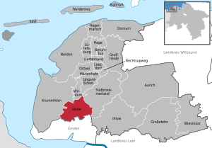
| Location of the community of Hinte in the district of Aurich | ||
  |
||


Hinte is a municipality in the Aurich district in East Friesland . With 7,106 inhabitants, it is one of the smaller communities in the district. With an area of 48 square kilometers, it is also the smallest unitary municipality on the mainland of the district. The inhabitants of Hintes are called Hinteraner, the adjective is also like this (for example Hinteraner Church ).
The core town of Hinte was first mentioned in a document around the year 1000, as were the current districts of Westerhusen and (Groß-) Midlum. The district of Loppersum was evidently inhabited by finds around the birth of Christ, but, like many other places in the East Frisian Marsch , had to be abandoned due to a transgression of the North Sea during the migration period.
Hinterte is now mainly inhabited by commuters who work mainly in the neighboring town of Emden. Economically, agriculture and tourism are of some importance. There is no industry in the community; it is considered structurally weak . The municipality's budget has therefore been dependent on financial equalization payments from the state of Lower Saxony for years .
The district of Suurhusen is known nationwide for its church. It has the most crooked church tower in the world . The church in the core town of Hinte , which, together with the neighboring castle, forms an ensemble that is rare in northern Germany, and the organ in the church in Westerhusen are also of outstanding importance . There are also a number of Gulf farms and farm workers' houses, as they are typical for East Frisian marshland areas .
geography
Position and extent
Behind lies in East Friesland in the extreme northwest of the Federal Republic of Germany. Politically and administratively, Hinte belongs to the Aurich district in Lower Saxony. The community is located in the south-west corner of the district in the immediate vicinity of the city of Emden . The district town of Aurich is 23 kilometers northeast, parts of the district administration are also in the city of Norden (25 kilometers north). The maximum north-south extension is about seven kilometers, as is the maximum west-east extension.
With a good 7,000 inhabitants, Hinte ranks 25th among the cities and municipalities in East Frisia in terms of population . Of the mainland communities - apart from the member communities of the integrated communities - only Jümme , Dornum and Jemgum are smaller. In terms of area, Hinte is even the bottom of the list in East Frisia with a little more than 48 square kilometers. The resulting population density of around 145 per square kilometer is very close to the East Frisian average of 148 inhabitants / km² and thus below the comparative values of Lower Saxony (168) and the Federal Republic (229).
Geology, soils and hydrology
The Hinteraner municipality is on average at an altitude of 1 to 1.5 meters above sea level . However, large parts of the municipality are below sea level, including the area south of the towns of Groß-Midlum, Westerhusen and Suurhusen, around Loppersum and northeast of Canhusen.
The geological subsurface of the community is determined by sediments from the Holocene . Behind is due to its relative proximity to the Ems and the fact that the Leybucht in earlier centuries extended to the current municipality area, one of the few municipalities in East Frisia that has no part of the Geest and therefore has no Pleistocene layers near the surface . The predominant landscape is the marsh . The former foothills of the Leybucht north of Canhusen and the Sielmönker Bucht between Cirkwehrum in the north, Groß-Midlum in the south and the core town of Hinte as the eastern end point consist of sea marsh soils , i.e. Kalkmarsch and Kleimarsch soils made of clay and silt with high productivity. Between Cirkwehrum, Hinte, Osterhusen and Canhusen, south of the Groß-Midlum – Suurhusen line and roughly east of the federal road 210 , there are Knickmarsch and transition brackish marshland . Around the Small Sea there are overlooked marginal moors ( flood moors ). Knick and bog marshes have a high density, because in earlier centuries the finest suspended matter penetrated the furthest inland and was deposited during flooding; the grain of the soil is therefore very fine. Correspondingly, the boggy and marshy soils are more difficult to cultivate.
.jpg)
The municipality is traversed in an (approximate) northeast-southwest direction by Knockster Tief , which also acts as a receiving water and ensures the drainage of the municipal area. Loppersum, Osterhusen and the core town of Hinte are located on it. Several other channels and branch channels, called lows there, flow to the knockster low. These include the Alte Greetsieler Sieltief , which flows into the Knockster Tief at Loppersum, and the Neue Greetsieler Sieltief , which flows into the Knockster Tief in the core town of Hinte. The villages of Suurhusen, Groß Midlum and Westerhusen are connected to the Knockster Tief by canals, the Cirkwehrum to the New and the Canhusen to the Alte Greetsieler Sieltief. This close-knit network of canal connections can be explained by the fact that the canals were the most important transport routes for the villages until the early 20th century, as the road network was insufficiently developed. The villages were connected to the city of Emden via the Knockster and the Hinter Tief . Since the local government reform in 1972, the low-level trek has been the south-eastern border to the neighboring town of Emden for long stretches.
The Small Sea is located in the municipality. The Loppersumer Meer , to the northwest of it, is named after the district of the same name, but is already in the area of the municipality of Südbrookmerland.
Land use
| use | Area in ha |
|---|---|
| Building and open space | 322 |
| including living space | 227 |
| of which commercial and industrial space | 4th |
| Operating area | 2 |
| Recreation area | 35 |
| including green area | 19th |
| traffic area | 250 |
| of which road, path, square | 235 |
| Agricultural area | 3,849 |
| Water surface | 246 |
| Forest area | 76 |
| Areas of other use | 25th |
| including cemeteries | 3 |
| of it land | 7th |
| total area | 4,806 |
80 percent of the community area is used for agriculture, making Hinte one of those communities that are above the East Frisian average of 75 percent. The Lower Saxony comparison value is 59 percent. The proportion of forest is 1.58 percent, which is below the East Frisian comparative value of 2.6 percent, which in turn is well below the national average of around 30 percent. Waters with the inland lake Hieve and the numerous canals and drainage ditches make up 5.11 percent of the municipal area.
Community structure
Hinterte has more than 7000 inhabitants, who are spread over a municipal area of around 48 square kilometers. Almost exactly 40 percent of the population live in the core town of Hinte, and the districts of Loppersum and Suurhusen also have a four-digit population. The rest consists of smaller villages with a three-digit population.
The following localities belong to the municipality of Hinte (in brackets the number of inhabitants in 2006):
| Locality | Residents | associated districts and places to live |
|---|---|---|
| Back | 2830 | Kringwehrum, Vliehaus, Wichhusen |
| Loppersum | 1400 | Abbingwehr , Bauerslust, Eisinghusen, Klein-Sande, Loppersumer Grashaus, Loppersumer Meedehaus, Meerbuden, Meinershof, Wilhelmshof |
| Suurhusen | 1175 | Haneborg, Onderbörg, Stikelborg, Suurhuser Hammrich, Tütelborg |
| Great Midlum | 760 | Horst, Leuchtenburg, Groß Midlumer Meede |
| Osterhusen | 500 | - |
| Westerhusen | 320 | Groß-Albringswehr, Harsweger brickworks, Mossenburg, Stadtwyk, Westerhuser Neuland |
| Circwehrum | 200 | Klein-Kringwehrum |
| Canhusen | 170 | Langewehr |
| total | 7355 | - |
Neighboring communities
Behind it borders on the following municipalities (starting in the south, clockwise): City of Emden, municipality of Krummhörn , municipality of Werdenum (in the joint municipality of Brookmerland ), municipality of Südbrookmerland . Apart from the independent city of Emden, the neighboring communities are located in the Aurich district.
climate
After the climate classification of Köppen , the community is in the classification Cfb . (Climate zone C : warm-temperate climate, climate type f : humid-temperate climate, sub-type b : warm summer ). Within the temperate zone, it is assigned to the climate district of Lower Saxony flatland North Sea coast , which has a maritime character and is characterized by relatively cool and rainy summers, relatively mild winters with little snow, prevailing westerly and south-westerly winds and high annual rainfall.
The closest measuring station of the German Weather Service is in Emden. The distance (as the crow flies) from the new town hall Hinte to this measuring station is only 3.6 kilometers, so that the measurements from the measuring station Emden also apply to Hinte.
|
Monthly average temperatures and precipitation for Emden (Wolthusen measuring station)
Source: German Weather Service
|
||||||||||||||||||||||||||||||||||||||||||||||||||||||||||||||||||||||||||||||||||||||||||
Protected areas
There are no nature reserves in the municipality. The landscape protection area (LSG) Großes Meer and the surrounding area has been under protection since 1972. It covers a flat area of 2148 hectares around the Great Sea and the Loppersumer Sea and also includes the Hieve . Most of the LSG is located in the Südbrookmerlander area, while the community of Hinte and the city of Emden have smaller shares. The latter landscape protection area and the nature reserves mentioned are part of the EU bird sanctuary of the East Frisian Sea . Another LSG is the approximately 10.2 hectare area near Hinta Castle, which has been under protection since 1965. Solitary trees in Cirkwehrum and Groß-Midlum are natural monuments.
history
The permanent settlement of the community area probably began in Loppersum. This is indicated by a bronze brooch from the earlier Roman Empire , which came to light in 1959 when the rectory was rebuilt on the Dorfwurt at a depth of two meters. Presumably the first inhabitants settled on the ground floor. Only the rise in sea level led to the throwing up of the warf. In the 5th century there was a sharp decline in settlement. The reason for this could have been the rise in sea levels in the course of the Dunkirk II transgression and the resulting flooding of the marshes and the watering of the Geest. The decline in population is only noticeable in the lack of archaeological finds for the 5th and 6th centuries.
After this decline in settlement, there was renewed settlement in the early 7th century. Based on their fertility, the reversible plow and suitable draft animals, presumably horses, soon led to extensive cultivation of the usable land in the unconsolidated marshland in the 8th and 9th centuries.
The core town of Hinte was probably built in the 9th century at a crossing point in the Emsgau where land and water connections met. The first written mention as Hinuti is dated around the year 1000. The place quickly gained in importance. The church of Hinte was originally a separate church of the bishops of Münster and the oldest in the Emsgau. The episcopal sending court also met in the churchyard . Originally, Brookmerland also belonged to the dean's office in Hinte, before it was separated from the diocese of Münster by an atonement contract in 1250 and placed under the episcopal official .
Hinte and Loppersum were the starting points for colonizing the region. Both began to cultivate their previously unused hinterland in the area of the Great Sea . The places Osterhusen and Westerhusen are medieval expansion settlements from Hinte, the initiative to settle Suurhusen probably came from Loppersum.
Chief time
In the mid-13th century the bishops hosted by Munster in Hinte a provost to which a stone house belonged. It forms the oldest part of the still preserved Hinta Castle . At first it probably served as the seat of the dean or provost appointed by the bishops and later became their property. A second castle, the Westerburg , was built by the local chief Habbo the Elder tho Hinta around 1312 on the western edge of the town. He was one of the most respected judges in the Emsigerland and represented the historical landscape at the Upstalsboom . In the 14th century, tensions among the East Frisian chiefs increased and finally resulted in open confrontation. The tom Brok had initially tried, with success, to establish sovereignty over the Friesland on both sides of the Ems. Opposition from the other sexes arose. Habbo the Younger, son of Habbo the Elder, began a campaign against Ocko I tom Brok from the castle in 1379 in alliance with Folkmar Allena . In the immediate vicinity of the castle, the opponents met this year in Loppersum . Habbo the Younger and Folkmar Allena emerged as losers from the battle. The winner, Ocko, had been married to Foelke Kampana , Habbo's sister , since 1377 . In the course of further disputes over supremacy, the local rulers sought cooperation with the Vitalien Brothers , whom the Teutonic Order had expelled from the Baltic island of Gotland in 1398 . As a result, the Hanseatic League saw itself threatened again and sent several punitive expeditions to East Frisia. In 1436, the Hanseatic League destroyed the Westerburg in Hinte. This was not rebuilt.
Under the Cirksena (1464 to 1744)
During the Thirty Years War , East Friesland was occupied three times by foreign troops as a retreat. Especially the first occupation by the troops of Ernst von Mansfeld meant a considerable burden for the population, as the mercenary heap strongly oppressed and plundered the inhabitants. When Mansfeld shifted parts of his troops from the fortress Leerort to Greetsiel and sent the war material by ship on the Ems downstream, ships from the heavily fortified and unconquered city attacked the convoy and, in addition to the private belongings of the military leader and his officers, captured 37 pieces of artillery , more than 2500 cannonballs, 209 quintals of powder and 180 quintals of fuses as well as various handguns, cutting and stabbing weapons. The captured artillery set up the Emden garrison on the Emder Wall , which contributed to the strengthening of the firepower. In total there were more than 200 guns on the wall. Mansfeld occupied the surrounding villages, including Hinte, and demanded the surrender of the booty, but in vain. The town councilors of Emden around the town councilor Johannes Althusius later let the mercenary leader know in a letter that they were "confident that we will part with pestilence, hunger and sorrow". The city itself was not affected in any way by the outbreak of the plague in East Friesland, but there were many deaths in the surrounding area, without any figures for the area of today's municipality.
The next two occupations also meant burdens from contributions. The occupiers from 1627 to 1631, however, imperial troops under Tilly , “kept discipline and avoided excesses”, as did the Hessian troops billeted from 1637 to 1651 under Wilhelm V von Hessen-Kassel . Materially, too, the situation was different under these two occupations than under Mansfeld: Although contributions were collected, these were also spent in the region. The East Frisian historian Tileman Dothias Wiarda had already pointed this out in Volume 5 of his East Frisian History (Aurich 1795): “Since, however, these contributions were almost completely consumed again in the province due to the many years of billeting, and the money always remained in circulation solve the mystery raised to some extent. ”During the war, the plague broke out in East Frisia, but deaths for the area are not documented.

The Christmas flood in 1717 had devastating consequences for the villages in what is now the municipality. Across the county, 2,787 people (about 3.6 percent of the population) lost their lives to the effects of the flood. The livestock also suffered heavy losses. A total of 2186 horses, 9430 cattle, 1031 pigs and 2682 sheep drowned. The ravages of the flood were followed by a period of economic decline and poverty.
During the Prussian and Napoleonic times (1744–1815)
After the double battle of Jena and Auerstedt in 1806, the municipality and the whole of East Frisia came to the Kingdom of Holland and in 1810 after its annexation to the French Empire . After the Wars of Liberation, East Frisia became Prussian again for a short time.
For centuries, the natural depths and drainage channels that crisscross the Krummhörn in a dense network were the most important modes of transport. Not only the villages but also many farms were connected to the city of Emden and the port of Greetsiel via ditches and canals. The boat traffic with Emden was particularly important. Village boatmen took over the supply of goods from the city and delivered agricultural products in the opposite direction: “From the Sielhafenort, smaller ships, so-called Loog ships, transported the cargo to the inland and supplied the marsh villages (loog = village). The Loogschiffe from the Krummhörn enlivened the canals of the city of Emden into the 20th century. ”In 1824 the historian Fridrich Arends wrote in his description of the land of the Principality of East Friesland and the Harlingerland :“ There is no office more abundant than this with water. (...) In winter and spring, the grain and other goods are always transported by water both in this and in the Greetmer office, which is extremely useful in the case of the poor clay paths in the season. "
Peat, which was mostly extracted in the East Frisian Fehnen , played an important role as heating material for the residents of Hintes for centuries. The peat ships brought the material on the East Frisian canal network to the Krummhörn villages, including to Hinte. On their way back into the Fehnsiedlungen the Torfschiffer often took clay soil from the march and the manure of cattle with which they their home were dug fertilized land.
Hanoverian Period and Empire (1815–1918)
After the Wars of Liberation, East Frisia became Prussian again for a short time. However, the states participating in the Congress of Vienna had agreed to swap territories, which also affected East Frisia: the Kingdom of Hanover came into being and remained so until it was dissolved after the war of German unification .
The social and economic contrasts between rich large farmers and poor agricultural workers, which had persisted throughout the 19th century, were by no means alleviated at the beginning of the 20th century. For Hinte, what was also found for other East Frisian marshland such as the neighboring Krummhörn was true: “During the march, the social differences were particularly sharp and harsh: on the one hand, tough and proud farmers, gentlemen through and through, on the other Side the day laborers. They, too, do not resemble the tribe and the farmers in terms of pride, but are economically oppressive.
Reports from farm workers state that the working days lasted from 4 a.m. to 6 p.m., interrupted by a one and a half hour lunch break. The farm workers often slept with the cattle in the stable if they did not have their own (and if they did, usually a very poor) little house. Already at the age of 13, immediately after attending school, the offspring were referred to farmers via so-called “ servants ”. In addition to other health problems, alcoholism was also widespread, especially since the spirits were mostly self- distilled and of poor quality.
From 1898 to 1963, Hinte had its own train station on the Emden – Pewsum – Greetsiel railway. After the meter-gauge route has been dismantled, local public transport is only available with buses.
Weimar Republic and National Socialism
In April 1919 there were so-called "bacon removals" from Emden workers, which were followed by rioting on the farm workers. Together with the Rheiderland , the district of Emden was the part of East Frisia most affected by this unrest. Workers broke into the surrounding villages in closed trains and stole food from farmers in clashes. The situation only calmed down after the deployment of the Reichswehr troops stationed in the region . As a reaction to this, resident groups were formed in almost all villages in the Emden area . The Hintes Resident Guard comprised 60 people. These had 20 weapons. Such weirs were also formed in other parts of today's municipality. The resident services were only dissolved after a corresponding decree by the Prussian Interior Minister Carl Severing on April 10, 1920.
As in the entire north-west of Lower Saxony, the rural people's movement was given a boost in the Weimar Republic after a bad harvest occurred in 1927 and the farmers were increasingly in dire straits. However, by focusing on quantities rather than quality, the problems were partly homemade. As in other parts of the country, the black flag, symbol of Florian Geyer's black crowd in the Peasants' War , fluttered as a sign of protest. The National Socialists, with their blood and soil ideology, saw themselves as guardians of the needs of the farmers and found appropriate support in many communities.
The farmers in the municipality were in the Reich into line . The passing of the Reichserbhofgesetz met with protests from many farmers, as they felt that their economic freedom of choice was limited. The ban on selling hereditary farms hit those businesses with the lower size limit of a hereditary farm of 7.5 hectares particularly. Although there were many judgments in favor of the plaintiff smallholders, the proportion of hereditary farms in the region remained above the national average.
post war period
On July 1, 1972, the municipalities of Canhusen, Cirkwehrum, Groß Midlum, Loppersum, Osterhusen, Suurhusen and Westerhusen were incorporated. A likewise discussed incorporation of the community area to Emden was rejected.
Development of the place name
The capital was first mentioned in the 10th century as being in Hinuti . The current spelling has been used since 1250/1251. The place was probably originally called Hunithi , a name that possibly goes back to the Germanic word for swamp, mold or brown, boggy . Behind means swamp area or area with brown earth . A derivation from Hinta = behind the Aa was also suggested.
religion

In the Middle Ages, the area of today's municipality of Hinte belonged to the provost office of Hinte in the diocese of Münster , which was one of seven provost districts in East Frisia and comprised ten parishes. Back had three priests around 1500, Suurhusen and Westerhusen each with two priests. In the course of the Reformation , the parishes adopted the Reformed Confession, which is prevalent to this day. The seven historic church buildings in the parish all belong to the Reformed Church . Almost 4,000 parishioners now belong to the Reformed Church. Suurhusen and Marienwehr have been united in one parish since 1877. Loppersum and Canhusen are looked after by a pastor couple. Cirkwehrum is connected to Uttum in a parish. Two pastors take care of the three parishes of Hinte, Westerhusen and Groß Midlum. They all belong to the Synodal Association of Northern East Friesland , which comprises 39 parishes with a total of 37,000 members.
The number of Lutherans rose sharply due to the influx of displaced people after the Second World War. Today about 1500 people in the Hinte congregation are Lutheran, but they do not have a place of worship in the congregation's territory. In accordance with the special East Frisian law, as laid down in the Emden Concordat in 1599 , they are looked after by the Reformed Church, but retain their own denomination status. Only a little more than 300 people belong to the Catholic Church, around 1200 from other faiths or none at all.
politics
Behind has the status of a unified community . Like East Friesland as a whole, the community has been a stronghold of the SPD for decades. There is always a clear majority for the SPD in state and federal elections - as was the case in the 2009 federal elections , although the SPD suffered significant losses in the entire constituency and received 38.8 percent of the vote. In the rear, however, the Social Democrats achieved 47.5 percent.
The strength of the Social Democrats in elections has existed since the first federal elections in 1949, but goes back to the Weimar Republic and in some cases even earlier. The basis was the high proportion of farm workers and commuters to the port and industrial companies in Emden. In the federal election in 1949 , the SPD achieved a majority in all of the former municipalities that now make up the eight localities. With the exception of Canhusen and Loppersums, it was an absolute majority everywhere. In 1949 the CDU only exceeded ten percent in Suurhusen and Westerhusen and was otherwise below that. In large parts of East Frisia, however, the Christian Democrats were not particularly well organized in the early stages of the Federal Republic - in contrast to the SPD, which could fall back on pre-war structures. In the federal election in 1953 there was an SPD majority in all eight localities, with the exception of Cirkwehrum and Westerhusen it was an absolute majority. This structure continued in the following years. The 1969 Bundestag election brought the CDU record results in large parts of East Frisia (without fundamentally changing anything in the dominance of the Social Democrats), but this was not reflected in the villages of Hintes: The Social Democrats achieved an absolute majority in all locations, which was the case with the " Willy Brandt election 1972 ”continued. In the years that followed, the SPD also had a comfortable lead over the CDU in federal and state elections.
Municipal council
The Hinte parish council consists of 20 councilors. This is the specified number for a municipality with a population between 7001 and 8000 inhabitants. The 20 council members are elected by local elections for five years each. The current term of office began on November 1, 2016 and ends on October 31, 2021.
The full-time mayor Manfred Eertmoed from the SPD is also entitled to vote in the municipal council.
Since the local elections on September 11, 2016, the council has consisted of four parties and the voter community Freie Liste Hinte (FLH). The SPD lost two seats in the 2016 election, but retains its clear majority in the council. The FLH gained one seat, the FDP moved into the local council with one seat.
Distribution of seats:
- SPD - 13 seats
- CDU - 4 seats
- Alliance 90 / The Greens - 2 seats
- Free List Rear (FLH) - 2 seat
- FDP - 1 seat
mayor
Since the community was formed in 1972, the SPD has had an absolute majority in the local council and, with one exception, has always appointed the mayor: initially as honorary mayor Bernhard Kappher (until 1991). Full-time mayor (head of administration) was from 1965 to 1972 with the name of joint municipality director and then from the establishment of the unified municipality (1972) until 2001 with the name of municipality director Garrelt Duin. He was one of the community directors with the longest term in office in Lower Saxony. He was succeeded for five years by Bernd Wolthoff, who had been honorary mayor since 1991. Afterwards Wolfgang Schneider was (independent) full-time mayor.
Manfred Eertmoed (SPD) won the mayoral election in Hinte on September 11, 2011 with 64.3% of the vote. He prevailed against competitors Dieter Meinen (17.1%), Berthold Tuitjer (11.6%) and Gerhard Hoffmann (6.9%). When Manfred Eertmoed took up his post on March 1, 2012, he took over from retired Wolfgang Schneider, who won the previous election in 2006 as an independent candidate with 62.87% of the vote against the SPD candidate Heinrich Ackmann (37.12%) .
Representatives in the Land and Bundestag
Hinte belongs to the Landtag constituency Emden / Norden , which consists of the city of Emden, the city of Norden and the municipalities of Krummhörn , Hinte and Hage . In the Lower Saxony state parliament ( legislature from 2017 ) two members are represented in the constituency. The directly elected MP is Matthias Arends (SPD). Hillgriet Eilers (FDP) also moved into the Lower Saxony state parliament via the state list . The SPD's second vote result of 49.4 percent was again the best of this party in the 87 electoral districts of Lower Saxony.
In Bundestag elections, Hinte belongs to constituency 24 Aurich - Emden . This includes the city of Emden and the district of Aurich. In the 2017 federal election , the social democrat Johann Saathoff was directly elected. No party candidate from the constituency entered the Bundestag via the parties' list.
coat of arms
|
|
Blazon : "In blue over a silver wave beam, a golden tower crowned with five battlements with an open gate." |
| Justification of the coat of arms: The tower symbolizes the Osterburg , which has been preserved to this day. The wave bar symbolizes the deep behind . |
Former coat of arms until 1972
 |
Blazon : "In blue a silver diagonal wave bar, accompanied at the top and bottom by a golden pinnacle tower with two loopholes and an open gate." |
| Foundation of the coat of arms: The two towers symbolize the Westerburg and the Osterburg, of which the Osterburg has been preserved to this day. The wave bar symbolizes the deep behind. |
flag
The flag of the municipality of Hinte has blue-white-yellow stripes and the municipality's coat of arms in the middle.
Economy and Transport
The rear is considered structurally weak. There is only one smaller industrial area in the municipality, which leads to correspondingly low trade tax income. The few businesses in the industrial park serve almost exclusively to cover basic needs. In the recent past, the municipality has always received separate needs allocations from the state of Lower Saxony, since the administrative budget could not be balanced regularly. Agriculture and, increasingly, tourism are of some importance.
In the back, however, there is a large number of out-commuters. Due to its proximity to Emden, the seaport city is the main destination for commuters, especially the VW plant and the port operations. 287 employees commute to Hinte, but in 1961 Hinteraner to work beyond the municipal boundaries (status: 2006). 2088 employees subject to social security contributions at the place of residence are compared to 414 jobs subject to social security contributions in the municipality.
No separate unemployment statistics are collected for the Hinte municipality. Together with the neighboring municipality of Krummhörn and the city of Emden, Hinte forms the statistical area of the Emden office within the district of the Emden-Leer employment agency . In December 2015, the unemployment rate in the area of the Emden branch was 7.1%, based on all civilian labor force. The unemployment rate was thus slightly higher than the average in East Frisia of 6.6 percent, the statistical area of the main agency Emden-Leer. However, since the unemployment rate in the city of Emden itself was 8.1% at that time, it was thus lower in the two rural communities than the average of the main agency Emden.
Agriculture
The district of Aurich is the eleventh largest milk producer district in Germany, to which the community of Hinte contributes to a certain extent due to the high proportion of grassland. More recently, the dairy farmers in the municipality have suffered from milk prices that are too low and more volatile.
tourism

Tourism has become a factor in the municipality's economic life in recent years. The rear benefits from the abundance of water in the municipality with a large number of channels known as lows and from the inland lake Hieve (also known as the Little Sea ), near which the two neighboring lakes Loppersumer Meer and Großes Meer are located. The three inland lakes have been linked by partly newly created paths since 2009 (Drei-Meere-Weg) . Since then, all three lakes can be hiked or circumnavigated on foot or by bike. Since some watercourses have to be crossed for this purpose, but these should be kept free for boat tourism, the participating municipalities of Hinte and Südbrookmerland have decided not to build bridges. Instead, two pünten (crank ferries) were built, with the help of which the road users can get from one bank to the other. Viewing platforms were also created.
traffic

The federal road 210 Wilhelmshaven - Emden runs through Hinterte , via which you can reach the Emden-Mitte junction of the Autobahn 31 , which is just behind the municipal boundary . The federal road has a length of about six kilometers in the municipality. The community is also traversed by Landesstraße 3, which branches off the B 210 at the northern border of Emden and leads via Hinte, Westerhusen and Groß-Midlum to Pewsum. The length of the state road in the Hinteraner area is about six kilometers. Because of the high volume of traffic on the B 210 (around 25,000 vehicles per day) and the volume of traffic on the L 3 (around 8,000 cars per day), there are often traffic disruptions for left-turners at the junction. There are also around 14 kilometers of district roads and around 250 kilometers of municipal roads. The localities of Cirkwehrum are connected to the core town of Hinte and Canhusen to Loppersum and Osterhusen / Hinte via district roads. These district roads lead from Hinte via Cirkwehrum to the neighboring municipality of Krummhörn and from Loppersum via Canhusen to the neighboring municipality of Werdenum. Another district road is the Neue Weg , which leads from Groß-Midlum to the Pewsum / Emden-Conrebbersweg junction on the A31. For the Hinte / Krummhörn area, it is an important feeder to the motorway and to the western Emden port area and to the Volkswagen plant there.
The Rheine – Norddeich Mole railway line of Deutsche Bahn also runs through the municipality . At the previous stops in Hinte, however, the trains now run through. The stop at the Emden – Pewsum – Greetsiel circuit was also given up in May 1963 and the line dismantled. The next train station is now Emden Hbf . The Weser-Ems-Bus lines 410, 421 and 423 run there from behind.
The nearest civil airfield is in Emden , which is directly adjacent to the Hinteraner municipality, but can only be reached via urban roads. The closest international airport is the one in Bremen .
In the past, Hinte, like the neighboring municipality of Krummhörn, was highly dependent on boat traffic on the canals, as the roads were poorly developed or even non-existent until the early 20th century. This was due on the one hand to the difficult soil and drainage conditions, and on the other hand to financial deficiencies. For the 18th century, for example, it is reported: “From Emden to Greetsiel. The path leads over Harsweg, Hinte, Wichhusen, Cirkwehrum, Damhusen, Dykhusen, Visquard and Appingen to Greetsiel. Length 3 1/2 hours. The path runs entirely on Kleiboden. It is low between Hinte and Harsweg, Dykhusen and Appingen and is often flooded when the winter water is high. "
education
There are three schools in the community. The Hauptschule and Realschule in the main town are attended by 390 children who are spread over 20 classes. There are also primary schools in the main town (eight classes with 180 students) and in Loppersum (eight classes with 161 students). Four kindergartens with a total of 209 places are available in the community for early childhood education. You are in Groß-Midlum (25 places), Suurhusen (25), Loppersum (50) and in the main town (109). The Hinteraner kindergarten is an integration kindergarten.
Further school offers can be found in the neighboring town of Emden. In Emden there is the Johannes-Althusius-Gymnasium , the Gymnasium am Treckfahrtstief , an integrated comprehensive school , a special needs school and two vocational schools . The Emden / Leer University of Applied Sciences is also located in Emden . The closest university is the Carl von Ossietzky University of Oldenburg .
media
Behind is in the circulation area of two regional daily newspapers. On the one hand, there is the Ostfriesen-Zeitung , which is published in Leer, and is the only daily newspaper in East Frisia to appear across the region. The second daily newspaper of concern is the Emder Zeitung , which is also widely read in the suburbs. Both newspapers look after the community from their offices in Emden. The Emder Zeitung publishing house also publishes an advertising paper that appears on Wednesdays as the home paper and on Sundays as the Sunday paper . From the community also reports of citizens broadcast transmitter Radio Ostfriesland .
Culture and sights
Churches and organs


Seven of the eight villages have church buildings. Among them, the Suurhus church from the middle of the 13th century is the oldest. It was built as a fortified church without a tower and an apse on a small terp , but has been rebuilt several times over the centuries. When the tower was added around 1450, the nave had to be shortened by a quarter. The Suurhus church became famous for its crooked church tower with 2.47 meters overhang, which has meanwhile earned it an entry in the Guinness Book of Records as the most crooked in the world. Two trapezoidal grave slabs with club head and tendril frieze as well as the cylindrical baptismal font made of Bentheim sandstone with the two tendril friezes, which stands on four lion feet, date from the 13th century . In the 19th century the north wall was rebuilt, the east wall partially renewed and the apse removed.
The Gross Midlum Church , which is dated around 1270 to 1280, is characterized by the Romano - Gothic transition style. The rectangular hall church with the semicircular east apse still has the high-seated, small, round-arched windows on the north side , while the pointed arches on the south side indicate a later enlargement. Under the apse there is a crypt for the noble villagers, which is now walled up. Instead of the original vaults, the interior is closed off by a wooden mirrored ceiling. The baroque pulpit, which Peter Gerkes Husmann created with the winding corner columns typical of the time, dates from 1690. Johann Friedrich Wenthin built an organ in 1803/04, of which only the historical prospectus has survived; behind it is a new work with twelve registers from 1956 by Alfred Führer .
The Westerhuser Church was built in the 15th century to replace the previous Romanesque building from the 13th century, of which the bell tower is still preserved. In 1964 remains of late Gothic frescoes were uncovered. The church stalls date from the 16th century, the pulpit dates back to 1642. The most valuable piece of furniture is the organ of the Westerhuser church from the years 1642/43. Organ builder Jost Sieburg used even older material from around 1500 for this purpose. The almost completely preserved instrument has seven stops on a manual and an attached pedal .
The rear church from around 1500 is considered to be the most important late Gothic church building in East Frisia , along with the Norder Ludgeri Church . Stylistic similarities exist with the north Dutch monastery of Ter Apel and the East Frisian group of Larrelter , Petkumer and Twixlumer churches . It is possible that the rear church was built on the model of the Benedictine monastery church of Sielmönken , which was consecrated in 1505. The preserved bell tower points to a previous building from the 13th century, the remains of which were integrated into the north wall. The well-preserved brick church with a polygonal choir is characterized on the outside by strong pillars, windows with sandstone tracery made of fish bubbles and pointed arches as well as a surrounding coffin cornice . The windows of the north wall are now partly bricked up, partly originally designed as blinds . The vaulted sacristy on the northeast side has not been preserved. The simply designed interior is structured by four yokes with belt arches. In the choir there is a three-rayed star vault , the shield and belt arches of which protrude to the floor, while in the nave the net vaults with intermediate ribs rest on chalice consoles . Remnants of the vault paintings in the choir polygon from the time the church was built show Christ as the judge of the world. On Vincent Lukas go some grave stones from the mid-16th century with Totentanz -representations back. Last supper table and choir stalls date from 1616, the cup-shaped baptismal font from 1569, the pulpit from 1695, the box stalls with traljeng lattice from 1761. Behind the organ front by Wenthin (1776–1781) there is a new work by Ahrend & Brunzema with eight registers (1958) .
The Cirkwehrum Church was built in 1751 as a baroque hall church on a terp. The tombstones from the previous church date from 1572, 1610 and 1612, on which two sisters are depicted almost life-size in their costumes. The Canhus Church , which emerged in 1789 from the completely rebuilt previous building, is already characterized by classicism . The bell from 1508 originally served in the Sielmönken monastery . The Loppersumer Church was built in the neo-Gothic style in 1866 after the Gothic church threatened to collapse. The oldest bell was cast in 1454.
Other structures


The Castle Hinta in the nucleus Hinte is the ancestral home of the family for about 400 years of Frese . The castle, surrounded by a moat, can only be viewed from the outside as it is still inhabited by the family.
The mill is also located in the core town of Hinte. This is a gallery Dutchman that can be viewed. The three-storey Dutch windmill with codend, built in 1869, fell victim to the great mill extinction and was demolished in 1958 except for the masonry. The mill, which was renovated in 1993, now houses a wedding room, exhibition rooms and a volunteer-run tea room.
Typical of the marshland of the Krummhörn and Hintes are large Gulf farms , where the big farmers lived and worked. They can often be found in the village centers. An example of this can be found in the village of Westerhusen, the Gulfhof Gerken . The courtyard dates from 1792 and is decorated with stone carvings, among other things. Farm workers' houses have also been preserved in several villages. These are the mostly one-room small houses of the former agricultural workers' proletariat. There is an example of these little houses in Suurhusen that has been expanded into a museum : It is a building that was erected in 1768 and that has been returned to its original state. The facility represents the living environment of the farm workers from around 1900. The house is part of a semi-detached house typical of the region , as farm workers often built. The house has a small stable, which is separated from the kitchen-living room by a corridor. In former times the farm workers kept some animals in such stalls for self-sufficiency. In the house the set into the walls are slugs to recognize who left as separated "bedroom" from the kitchen. A farm workers' house, which is rather unusual for the Krummhörn / Hinte area, can be found in Cirkwehrum: It has a small barn , which indicates that the residents cultivated a piece of land themselves in addition to their work on large farms. In addition, it has a garden of around 1,600 square meters, which in earlier times was also used for self-sufficiency.
Regular events
Concerts of the Krummhörner Orgelfrühling event series take place every year in the churches of the community . In addition, the churches serve the concerts of the series Tidal Concerts in East Friesland and Musical Summer in East Friesland .
language

In Hinte, East Frisian Platt is spoken in addition to High German . Due to the influx of Dutch religious refugees after the Reformation , the Dutch language was also widespread, at least in the Reformed church, which was brought in mainly by the pastors. However, this declined sharply in the 19th century, when East Frisia increasingly oriented itself culturally towards Germany and the Reformed pastors were trained in German-speaking areas. Today, Dutch hardly plays a role any more, apart from a strong mix of language in the local dialect .
The Low German is anchored in the community well. There are Low German church services and it is quite common for weddings and similar events to be held in Low German .
Sports
In the community there are the universal sports clubs FT Groß Midlum, TuS Eintracht Hinte, Concordia Suurhusen and WT Loppersum. Eintracht Hinte produced the hurdler and Olympic participant Silvia Rieger . The volleyball ladies from Eintracht Hinte as well as the soccer men from Concordia Suurhusen played in the past at regional or association league level, so they made a name for themselves beyond the borders of East Frisia. Both teams are now back in the lower class.
The Hieve , also known as the Little Sea , lies in the area of the municipality of Hinte . There is a colony of weekend houses there. The Small Sea is a popular water sports area, and many of the holiday homes located directly on the shore have jetties. The small sea is connected to the city of Emden and thus to the East Frisian waterway network via the treckage low . There are two water sports clubs in Hinte and Loppersum. In addition, there is an equestrian club at the rear.
Personalities
The East Frisian chief Folkmar Allena (* unknown; † 1406 ) had his main castle in Osterhusen. Foelke Kampana (1355-1417 / 19), known as Quade Foelke , was born in Hinte , the wife of Chief Ocko I. tom Brok . The theologian Johannes a Lasco (Polish: Jan Łaski) (* 1499 in Łask , Poland ; † January 8, 1560 in Pinczów , Poland) lived in the Kommende Abbingwehr from 1546 to 1549 . The princely personal physician and humanist Adolph Occo (1447–1503) was born in the Osterhusen district .
Enne Heeren Dirksen (born January 3, 1788 in Eilsum , East Frisia ; † July 16, 1850 in Paris ), professor of mathematics, worked as a teacher in Hinte before studying in Göttingen. The theologian and local researcher Otto Galama Houtrouw (born June 16, 1838 in Gandersum , † February 14, 1933 in Oldersum ) worked as an assistant preacher in Loppersum. The teacher and local researcher Dodo Wildvang (* 1873, † 1940) was born in Groß-Midlum. He was best known for his work on the geology of East Frisia. The reformed theologian and state superintendent Gerhard Nordholt (born October 9, 1920 in Schüttorf , Grafschaft Bentheim ; † November 27, 1994 in Emlichheim ) completed his vicariate in Hinte and Westerhusen.
The former SPD member of the Bundestag for the Aurich / Emden constituency and former Minister for Economic Affairs, Energy, Industry, SMEs and Crafts in North Rhine-Westphalia, Garrelt Duin , was born in Leer, but has lived in Hinte for a long time. The CDU member of the state parliament (constituency Emden / Norden) Reinhard Hegewald was born on June 2, 1964 in Loppersum. The athlete and multiple German champion over 400 meter hurdles, Silvia Rieger , also comes from the community . She started u. a. for TuS Eintracht Hinte.
Web links
Individual evidence
- ↑ State Office for Statistics Lower Saxony, LSN-Online regional database, Table 12411: Update of the population, as of December 31, 2019 ( help ).
- ↑ a b c hinte.de: Figures / Data / Facts , accessed on August 7, 2011.
- ↑ www.entwaesserungsverband-emden.de: Map of the association area , PDF file, accessed on January 5, 2013.
- ^ Günter Roeschmann: The soils of East Friesland. In: Karl-Heinz Sindowski et al: Geology, Soils and Settlement of Ostfriesland (Ostfriesland im Schutz des Deiches, Volume 1), Deichacht Krummhörn (Ed.): Selbstverlag, Pewsum 1969, p. 51-106, here p. 96 as well as cartographic supplement .
- ^ Theodor Janssen: Hydrology of East Frisia. Verlag Ostfriesische Landschaft, Aurich 1967, without ISBN, p. 211 ff.
- ^ Eberhard Rack: Kleine Landeskunde Ostfriesland , Verlag Isensee, Oldenburg 1998, ISBN 3-89598-534-1 , p. 115.
- ↑ Updated world climate map of the Köppen-Geiger climate classification , viewed on December 28, 2011.
- ^ Wolfgang Schwarz: Prehistory and early history. In: Karl-Ernst Behre, Hajo van Lengen: Ostfriesland. History and shape of a cultural landscape , Aurich 1995, ISBN 3-925365-85-0 , p. 72.
- ↑ a b Wolfgang Schwarz: Use of the moor marshland in western East Friesland; the breeding ground for economic and social transformation in the 10th century ( memento of October 29, 2013 in the Internet Archive ) (PDF; 2.2 MB). In: News of the Marschenrat to promote research in the coastal area of the North Sea . Issue 46/2009. P. 69ff. Accessed December 3, 2012.
- ↑ a b Silke Arends: Because nobility obliges . In Ostfriesland Magazin . Edition 12/2012. Pp. 91 to 97.
- ^ A b Günter Müller: 293 castles and palaces in the Oldenburg area - East Frisia . Oldenburg 1977. pp. 160 f.
- ↑ Wolfgang Brünink: Der Graf von Mansfeld in Ostfriesland (1622-1624) (Treatises and lectures on the history of East Frisia, Volume 34), Verlag Ostfriesische Landschaft, Aurich 1957, without ISBN, p. 91.
- ↑ Wolfgang Brünink: Der Graf von Mansfeld in Ostfriesland (1622-1624) (Treatises and lectures on the history of East Frisia, Volume 34), Verlag Ostfriesische Landschaft, Aurich 1957, without ISBN, p. 136, note 174.
- ^ Walter Deeters: Ostfriesland in the Thirty Years War , in: Emder Yearbook for Historical Regional Studies Ostfrieslands , Vol. 78 (1998), pp. 32–44, here: p. 38.
- ^ Walter Deeters: Ostfriesland in the Thirty Years War , in: Emder Yearbook for Historical Regional Studies Ostfrieslands , Vol. 78 (1998), pp. 32–44, here: p. 39.
- ↑ Quoted from: Walter Deeters: Ostfriesland in the Thirty Years War , in: Emder Yearbook for Historical Regional Studies Ostfrieslands , Vol. 78 (1998), pp. 32–44, here: p. 43.
- ↑ Aiko Schmidt ( Ostfriesisches Landesmuseum Emden ): Artwork of the month December 2003: The Christmas flood 1717 . Accessed November 6, 2013.
- ↑ Manfred Jakubowski-Tiessen: Storm surge 1717: Coping with a natural disaster in the early modern period Oldenbourg Wissenschaftsverlag. Munich 1992. ISBN 3-486-55939-7 . P. 63.
- ^ Harm Wiemann / Johannes Engelmann: Old streets and ways in East Frisia . Self-published, Pewsum 1974, p. 169 (East Frisia in the protection of the dyke; 8)
- ↑ Fridrich Arends: Erdbeschreibung des Fürstenthums Ostfriesland and Harlingerlandes , Emden 1824. Online in the Google book search, p. 279 ff., Accessed on July 10, 2013.
- ^ Gunther Hummerich: The peat shipping of the Fehntjer in Emden and the Krummhörn in the 19th and 20th centuries. In: Emder Yearbook for Historical Regional Studies in Ostfriesland , Volume 88/89 (2008/2009), pp. 142–173, here p. 163.
- ^ Theodor Schmidt: Analysis of the statistics and relevant sources on the federal elections in East Friesland 1949-1972 . East Frisian Landscape, Aurich 1978, p. 70.
- ↑ Printed and commented in: Onno Poppinga / Hans Martin Barth / Hiltraut Roth: Ostfriesland. Biographies from the Resistance. , Syndicate authors and publishing company, Frankfurt / Main 1977, ISBN 3-8108-0024-4 , pp. 26–32.
- ↑ Hans Bernhard Eden: The Resident Services of Ostfriesland from 1919 to 1921. In: Emder Yearbook for Historical Country Studies of Ostfriesland , Vol. 65 (1985), pp. 81-134, here pp. 94, 98, 105, 114.
- ↑ Beatrix Heilemann: The East Frisian Agriculture in National Socialism. In: Emder Yearbook for Historical Regional Studies Ostfriesland , Vol. 81 (2001), pp. 205–216, here: pp. 205f.
- ↑ Beatrix Heilemann: The East Frisian Agriculture in National Socialism. In: Emder Yearbook for Historical Regional Studies Ostfriesland , Vol. 81 (2001), pp. 205–216, here: pp. 209f.
- ^ Federal Statistical Office (ed.): Historical municipality directory for the Federal Republic of Germany. Name, border and key number changes in municipalities, counties and administrative districts from May 27, 1970 to December 31, 1982 . W. Kohlhammer GmbH, Stuttgart and Mainz 1983, ISBN 3-17-003263-1 , p. 263 .
- ^ Ortschronisten der Ostfriesische Landschaft : Hinte, administrative seat of the municipality of the same name, district Aurich (PDF; 732 kB), accessed on January 11, 2013.
- ↑ Hanswilhelm Haefs: Ostfriesland , Norderstedt 2013, p. 206. Similarly, the website of the East Frisian landscape ( Memento from February 20, 2014 in the Internet Archive ) (PDF, 73.4 kB).
- ↑ Menno Smid: East Frisian Church History . H. Risius, Weener 1974, p. 43 (Ostfriesland in the protection of the dike, vol. 6).
- ^ Synodalverband Nördliches Ostfriesland , as seen on January 13, 2013.
- ↑ hinte.de: Parishes in Hinte , seen January 13, 2013.
- ↑ Klaus von Beyme : The political system of the Federal Republic of Germany: An introduction , VS Verlag, Wiesbaden 2004, ISBN 3-531-33426-3 , p. 100.
- ^ Election result back at www.landkreis-aurich.de ( Memento from September 28, 2009 in the Internet Archive ), accessed on December 28, 2016.
- ↑ This paragraph is based on Theodor Schmidt: Analysis of the statistics and relevant sources on the Bundestag elections in East Frisia 1949-1972 . East Frisian Landscape, Aurich 1978, cartographic appendix.
- ^ Lower Saxony Municipal Constitutional Law (NKomVG) in the version of December 17, 2010; Section 46 - Number of MPs , accessed on December 28, 2016.
- ↑ Main compilation of the results of the municipal council election on September 11 , 2016, accessed on December 28, 2016 (PDF).
- ↑ www.oz-online.de: First signature on the greeting card , in: Ostfriesen-Zeitung of March 2, 2012, accessed on December 28, 2016.
- ^ Nordwest-Zeitung: Bundestag election: These members represent our region . In: NWZonline . ( nwzonline.de [accessed September 29, 2017]).
- ↑ www.hinte.de: Historical overview , accessed on August 7, 2011.
- ^ Statistics from the Federal Employment Agency, Excel file, line 2066
- ↑ Labor market report, Employment Agency Emden-Leer, December 2015 ( page no longer available , search in web archives ) Info: The link was automatically marked as defective. Please check the link according to the instructions and then remove this notice. , P. 19 (PDF file; 1.38 MB).
- ↑ berufsagentur.de, press release No. 01 from January 5, 2016 ( page no longer available , search in web archives ) Info: The link was automatically marked as defective. Please check the link according to the instructions and then remove this notice. , accessed February 2, 2016.
- ↑ Lower Saxony State Office for Statistics , quoted in: Ostfriesischer Kurier , August 14, 2008, p. 12
- ↑ projekt-grosses-meer.de: A way to experience the sea , accessed on April 26, 2011
- ↑ Harsweg: Road authorities get the curve , Ostfriesen-Zeitung, March 1, 2011, accessed on August 7, 2011.
- ^ Harm Wiemann / Johannes Engelmann: Old streets and ways in East Frisia . Self-published, Pewsum 1974, p. 161 (East Frisia in the protection of the dyke; 8)
- ↑ www.hinte.de: Schools , accessed on January 5, 2013.
- ↑ www.hinte.de: Kindergartens , accessed on January 5, 2013.
- ^ Homepage of the parish , as seen on August 9, 2011.
- ^ Genealogy forum: Groß-Midlum ( memento of September 24, 2015 in the Internet Archive ), as of August 9, 2011.
- ↑ organ in Westerhusen at NOMINE eV , seen on Aug. 9, 2011.
- ↑ Gottfried Kiesow : Architectural Guide Ostfriesland . Verlag Deutsche Stiftung Denkmalschutz , Bonn 2010, ISBN 978-3-86795-021-3 , p. 109f.
- ^ Hermann Haiduck: The architecture of the medieval churches in the East Frisian coastal area . Verlag Ostfriesische Landschaft, Aurich 1986, ISBN 3-925365-07-9 , p. 167 .
- ^ Hermann Haiduck: The architecture of the medieval churches in the East Frisian coastal area . Verlag Ostfriesische Landschaft, Aurich 1986, ISBN 3-925365-07-9 , p. 169 .
- ↑ organ on NOMINE eV , seen on Aug. 9, 2011.
- ↑ Homepage of the Canhus Church , as seen on August 9, 2011.
- ↑ Ude Hangen (local chronicle of the East Frisian landscape ): Loppersum (PDF file; 108 kB), viewed August 9, 2011.
- ↑ www.hinte.de: The farm workers' house in Suurhusen , accessed on January 5, 2013.
- ↑ Johann Aeils / Jan Smidt / Martin Stromann: Stone witnesses in March and Geest: Gulfhöfe and workers' houses in East Friesland. 3rd, revised edition, Verlag SKN, Norden 2007, ISBN 978-3-928327-16-9 , p. 107.
- ↑ Johann Aeils / Jan Smidt / Martin Stromann: Stone witnesses in March and Geest: Gulfhöfe and workers' houses in East Friesland. 3rd, revised edition, Verlag SKN, Norden 2007, ISBN 978-3-928327-16-9 , p. 106.
- ↑ www.hinte.de: Clubs , accessed on January 5, 2013.
- ↑ Most of the older sources cite the probably incorrect year of birth 1792 given by Dirksen himself; see. Article in the biographical lexicon Ostfriesland
Aurich | Baltrum | Berumbur | Dornum | Großefehn | Großheide | Hage | Hagermarsch | Half moon | Rear | Ihlow | Juist | Krummhörn | Leezdorf | Lütetsburg | Marienhafe | North | Norderney | Osteel | Rechtsupweg | South Brookmerland | Upgant bulkhead | Wiesmoor | Willum
Non- parish area in the Aurich
Memmert district