Kottwil
| Kottwil | ||
|---|---|---|
| State : |
|
|
| Canton : |
|
|
| Constituency : | Willisau | |
| Residential municipality : | Ettiswil | |
| Postal code : | 6217 | |
| former BFS no. : | 1133 | |
| Coordinates : | 646000 / 223.62 thousand | |
| Height : | 517 m above sea level M. | |
| Area : | 6.09 km² | |
| Residents: | 398 (December 31, 2004) | |
| Population density : | 65 inhabitants per km² | |
| Website: | www.ettiswil.ch | |
|
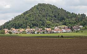
Kottwil with Kottwiler Gütsch |
||
| map | ||
|
|
||
Until December 31, 2005, Kottwil was a municipality in the Willisau district of the canton of Lucerne in Switzerland .
On January 1, 2006, Kottwil merged with the Ettiswil community to form the new Ettiswil community.
geography
Kottwil is located on the southern edge of the Wauwilermoos on the road from Sursee to Willisau . East of the village the rises Kottwiler Gütsch (654 m. U. M.), which in part from Gütsch forest is covered. The Zuswiler Gütsch (658 m above sea level) rises south of the village . It is also partially wooded ( Zuswilerwald ). Both are the most north-westerly foothills of the Leidenberg. With the Dreizwingenwald there is finally a third, larger forest area on the former communal soil . A total of 17.2% of the village is covered with forest and wood. Since the drainage of the Wauwilersee and the Wauwilermoos, the majority has been an agricultural area (76.8% of the former municipality area). Only small remnants of the marshland survived the drainage. They include the Hagimoos in the northeast and the ponds at Rothubel in the very southwest of the village. In addition to the village, various hamlets and individual farms also belong to Kottwil. The largest are the hamlet of Seewagen 1 km to the north and the merged hamlets of Kreuzacher and Zuswil 1 km southwest of the main settlement. Overall, however, there is only 5.1% settlement area.
Former neighboring communities
Kottwil bordered Ettiswil , Grosswangen , Mauensee , Schötz and Wauwil .
population
Population development
Kottwil never had a large number of residents. With the exception of 1870–1880, this sank massively from 1850 to 1920 due to emigration (1850–1920: −21.4%). Thanks to a growth period from 1920 to 1950 (1920–1950: +28.3), the original population could be reached again. A second wave of emigration followed between 1950 and 1990 (1950–1990: −26.1%). These two corner years stand for the highest (1950) and lowest (1990) population. From 1990 the population grew again significantly (1990–2004: +30.9%).
| Population development | |
|---|---|
| year | Residents |
| 1850 | 472 |
| 1870 | 428 |
| 1880 | 450 |
| 1920 | 371 |
| 1950 | 476 |
| 1960 | 387 |
| 1980 | 311 |
| 1990 | 304 |
| 2000 | 386 |
| 2004 | 398 |
languages
The population uses a highly Alemannic dialect as their everyday language. At the last census in 2000, 99.22% said German, 0.52% French and 0.22% Romansh were the main languages.
Religions - denominations
In the past, all residents were members of the Roman Catholic Church. This has changed as a result of leaving the church and immigration from other regions in Switzerland and abroad. Today (as of 2000) the religious landscape looks like this. There are 83.94% Roman Catholic and 9.59% Evangelical Reformed Christians. In addition, there are still 2.33% without religious affiliation.
Origin - nationality
Of the 398 inhabitants at the end of 2004, 386 were Swiss and 12 (= 3.0%) were foreigners. At the last census, 95.85% (including dual citizens 96.11%) were Swiss citizens. The few foreigners come from Serbia-Montenegro, Germany and Sri Lanka.
traffic
Kottwil is not on any railway line. It is connected to the public transport network with the Sursee-Willisau bus line. There are train stations at the two endpoints. Willisau is on the Lucerne-Langenthal line and Sursee on the Lucerne-Olten line.
Kottwil is on the road from Sursee to Willisau. The next motorway junction Sursee is only 7 km away.
history
In Hauenbühl northwest of the village remains have been found from the Middle Stone Age. Settlement remains, tools and jewelery have also been found from other early periods. During excavations, the foundations and remains of a Roman villa came to light. An Alemannic fortified settlement once stood on the hill to the east of the village. An Alemannic equestrian grave also dates from this time. Chotwile is first mentioned historically in a letter of protection from Emperor Friedrich I to the Canons of Beromünster . Later the Habsburgs took over the rule and Kottwil became part of the bailiwick of Willisau. In 1415 the Lucerne people took over the rule. It was part of the Kastelen rule. The Schnyder family from Sursee exercised the right to twing from 1520 to 1798 . Until 1803 it was part of the Willisau district. Then to the newly established Sursee Office .
Attractions
Web links
- Waltraud Hörsch: Kottwil. In: Historical Lexicon of Switzerland .


