
Zell LU
| LU is the abbreviation for the Canton of Lucerne in Switzerland and is used to avoid confusion with other entries of the name Zell . |
| Cell | |
|---|---|
_COA.png) |
|
| State : |
|
| Canton : |
|
| Constituency : | Willisau |
| BFS no. : | 1150 |
| Postal code : |
6144 (Zell LU) 6152 (Hüswil) |
| UN / LOCODE : | CH ZZL |
| Coordinates : | 637 532 / 220379 |
| Height : | 590 m above sea level M. |
| Height range : | 560–782 m above sea level M. |
| Area : | 13.91 km² |
| Residents: | 2038 (December 31, 2018) |
| Population density : | 147 inhabitants per km² |
|
Proportion of foreigners : (residents without citizenship ) |
11.6% (December 31, 2,015) |
| Website: | www.zell-lu.ch |
 Cell |
|
| Location of the municipality | |
  |
|
Zell is a municipality in the Willisau constituency in the canton of Lucerne in Switzerland .
geography
The community is located about 6 km northwest of Willisau in the front valley of the Luthern and is a regional center. In addition to the village, the municipality includes the two districts Briseck ( 582 m above sea level ; 1 km east of the village) and Hüswil ( 613 m above sea level ; 1.7 km southwest of Zell-Dorf), where the Warmisbach flows into the (Gondiswiler-) Rotbach flows into it. Apart from the Luthern Valley , which is flat, the rest of the municipality is in the hill country. In the northeast of the municipality are the hamlets Hällershof ( 702 m above sea level ; 2.4 km northeast of the village), Bründlen ( 693 m above sea level ; 1.1 km northeast) and Hünkihof ( 720 m above sea level ; 1.4 km northeast). In the north of the village is the Guggihöhe ( 724 m above sea level ), to the northwest of the Zellerwald . The highest point in the municipality is Salberig ( 782 m above sea level ; 2 km south of the village).
68.0% of the municipal area of almost 13.88 km² is used for agriculture. Forest and wood cover 22.8% of the area and 8.9% are settlement areas.
Zell borders on the communities Altishofen , Fischbach , Gettnau , Schötz , Ufhusen and Willisau .
population
| Population development | |
|---|---|
| year | Residents |
| 1798 | 831 |
| 1850 | 1,355 |
| 1860 | 1,177 |
| 1888 | 1,155 |
| 1941 | 1,713 |
| 1960 | 1,582 |
| 1970 | 1'590 |
| 1990 | 1,795 |
| 2000 | 1,975 |
| 2004 | 1'967 |
| 2006 | 1,938 |
The population grew rapidly until the middle of the 19th century (1798–1850: + 63.1%). Mass emigration followed in the 1850s (1850–1860: −13.1%), followed by a phase of stagnation that lasted until 1888. After that, the population grew again strongly until 1941 (1888–1941: + 48.3%). After the Second World War there was another wave of emigration up to 1960 (1941–1960: −7.6%). From 1970 to 2000 the population grew again considerably (1970–2000: + 24.2%). Since then the population has stagnated.
languages
The population uses a highly Alemannic dialect as colloquial language. At the last census in 2000, 94.84% said German, 1.67% Albanian and 0.81% Portuguese were their main languages.
Religions - denominations
In earlier times the entire population was members of the Roman Catholic Church. This has changed as a result of leaving the church and immigration from other regions in Switzerland and abroad. Today (as of 2000) there are 77.72% Roman Catholic and 15.65% Evangelical Reformed Christians. In addition, there are 2.28% Muslims and 0.61% each without denomination and members of other non-Christian religions (mostly Hindus of Tamil origin). The Muslims are almost exclusively Albanians from Kosovo and Macedonia.
Origin - nationality
At the end of 2014, 1,767 of the 1,999 inhabitants were Swiss and 232 (= 11.6%) foreigners. The population consisted of 88.4% Swiss citizens. At the end of 2014, the foreign residents came from Serbia including Kosovo (26.7%), Portugal (16.4%), Germany (10.8%) and Italy (3.0%). 18.1% came from the rest of Europe and 25.0% were of non-European origin.
history

The area was settled before the Common Era, as evidenced by the discovery of a bronze ax. A Roman gold coin was also unearthed. Celle is mentioned for the first time in 1275 in a papal collective register for the collection of the crusade tax. Until 1407 the community belonged to the county of Willisau, which was owned by the Habsburgs . These handed over the reign to the Lords of Büttikon. In 1407 the city of Lucerne acquired the county. Until 1798, Zell was part of the Willisau Landvogtei. From 1798 to 1803 the place was assigned to the Willisau district, which then became part of the newly created Willisau Office .
politics
Municipal council
The Zell municipal council consists of five members for the 2016-2019 electoral period and is composed as follows:
- Markus Tremp ( CVP ): Mayor
- Meinrad Birrer (CVP): Chief Financial Officer
- Alfred Hofer ( FDP ): head of the school
- Karin Meier (FDP): Social Director
- Urs Lustenberger (CVP): Site Manager
Cantonal elections
In the 2015 Cantonal Council elections for the Canton of Lucerne, the proportion of voters in Zell was: CVP 52.0%, FDP 22.3%, SVP 18.8%, GPS 3.4%, SP 2.7%, glp 0.8%.
National Council elections
In the 2015 Swiss parliamentary elections, the share of the vote in Zell was: SVP 33.8%, CVP 31.9%, FDP 21.2%, SP 5.2%, Greens 3.1%, glp 1.9%, BDP 1, 6%.
traffic
With Zell and Hüswil, Zell has two stops on the Lucerne-Langenthal line of the Lucerne S-Bahn . The community is a local bus hub. The bus routes Zell-Altbüron-St. Urban , Hüswil-Ufhusen and Zell-Hüswil-Hofstatt-Luthern-Luthern Bad open up the surrounding area by public transport. Zell is on the streets Willisau-Huttwil and Zell-St Urban. The closest motorway connections are Dagmersellen 12 km and Sursee 16 km away. Both are on the A2 .
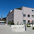
Attractions
photos
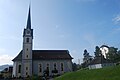
St. Martin Church

Primary school
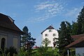
Rectory
Rectory
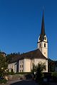
Parish Church of St. Martin
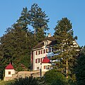
Local government

Secondary school house

Gym, secondary school


Web links
- Official website of the municipality of Zell
- Community profile of the cantonal statistical office (PDF; 110 kB)
- Waltraud Hörsch: Zell (LU). In: Historical Lexicon of Switzerland .
Individual evidence
- ↑ Permanent and non-permanent resident population by year, canton, district, municipality, population type and gender (permanent resident population). In: bfs. admin.ch . Federal Statistical Office (FSO), August 31, 2019, accessed on December 22, 2019 .
- ↑ Permanent resident population according to nationality category, gender and municipality ( memento of the original from January 1, 2015 in the Internet Archive ) Info: The archive link was inserted automatically and has not yet been checked. Please check the original and archive link according to the instructions and then remove this notice. (Permanent resident population)
- ↑ Balance of the permanent resident population according to demographic components, institutional structure, nationality and gender (Federal Statistical Office, STAT-TAB)
- ↑ LUSTAT: Community profile Zell ( Memento of the original from May 8, 2016 in the Internet Archive ) Info: The archive link was automatically inserted and not yet checked. Please check the original and archive link according to the instructions and then remove this notice.
- ↑ Municipal council on the website of the municipality of Zell
- ↑ LUSTAT: Community profile Zell ( Memento of the original from May 8, 2016 in the Internet Archive ) Info: The archive link was automatically inserted and not yet checked. Please check the original and archive link according to the instructions and then remove this notice.
- ↑ National Council elections 2015: strength of the parties and voter turnout by municipality. In: Results of the National Council elections 2015. Federal Statistical Office, 2016, accessed on June 3, 2016 .
Alberswil | Altbüron | Altishofen | Dagmersellen | Egolzwil | Ettiswil | Fischbach | Gettnau | Grossdietwil | Hergiswil near Willisau | Luther | Menznau | Nebikon | Pfaffnau | Reiden | Roggliswil | Schötz | Ufhusen | Wauwil | Wikon | Willisau | Cell
Former parishes: Buchs | Boar corners | Kottwil | Langnau near Reiden | Ohmstal | Richenthal | Uffikon | Willisau Land | Willisau city
Canton of Lucerne | Constituencies of the Canton of Lucerne | Municipalities of the Canton of Lucerne