
Meram (Konya)
| Meram | ||||
|
||||
| Basic data | ||||
|---|---|---|---|---|
| Province (il) : | Konya | |||
| Coordinates : | 37 ° 52 ' N , 32 ° 27' E | |||
| Height : | 1044 m | |||
| Surface: | 1,949 km² | |||
| Residents : | 342,315 (2018) | |||
| Population density : | 176 inhabitants per km² | |||
| Telephone code : | (+90) 332 | |||
| Postal code : | 42030 | |||
| License plate : | 42 | |||
| Structure and administration (as of 2019) | ||||
| Mayor : | Mustafa Kavuş ( AKP ) | |||
| Website: | ||||
| Meram district | ||||
| Residents : | 342,315 (2018) | |||
| Surface: | 1,949 km² | |||
| Population density : | 176 inhabitants per km² | |||
| Kaymakam : | Resul Çelik | |||
| Website (Kaymakam): | ||||


Meram is a city and a district in the Turkish province of Konya . Since a regional reform in 2014 , the municipality ( Belediye ) is congruent with the district ( İlçe ). All previous villages ( Köy ) are now districts ( Mahalle ) of the municipality. Meram is the southwestern part of the central city of Konya .
The district is located in the center of the province. It borders in the east on Karatay and Çumra , in the south on Akören , in the west on Seydişehir and Beyşehir , in the north-west on Derbent and in the north on Selçuklu . The D-330 to Beyşehir and Isparta and D-696 to Seydişehir and south to Akören and Bozkır run through the district from Konya to the west . In the north is the southern slope of the Selçuk Dağı mountain range with a height of 2050 meters, in the south the northeastern part of the Erenler Dağı with the 1221 meter high Topattıran Tepesi peak . Lake Gavur Gölü is located on the western border with Seydişehir . Various small rivers flow from its surroundings to the east, one of which is dammed further east, on the border with Akören, to the Hatunsaray Barajı . According to the city administration from 2019, the area of Merams is 1,949 km².
There are various details about the altitude of the city, mostly 1,044 m are given, the city administration of Meram mentions 1,016 m, the English Wikipedia 1,037 m (without reference).
Districts
The following former villages ( Köy ) are now districts ( Mahalle ) of Meram:
- Bayat
- Boruktolu
- Çayırbağı
- Çukurçimen
- Erenkaya
- Evliyatekke
- Gödene
- Gokyurt
- Güneydere
- Hasanseyh
- Hatunsaray
- İkipınar
- İnlice
- Karaağaç
- Karadiğin
- Karadiğinderesi
- Kaşınhanı
- Kavak
- Kayhüyük
- Kızılören
- Kumralı
- Loras
- Pamukcu
- Sağlık
- Sarıkız
- Telafer
- Yenibahçe
- Yeşildere
- Yeşiltekke
history
Planning for the Meram District began on June 20, 1987 as part of the Konya Metropolitan Area that was formed on June 27, 1987. On August 8, 1988 the district was constituted. In 2014, the municipality of Meram was merged with the district of Meram as part of a regional reform.
Attractions
In the northeast of the district is the southwest part of the city of Konya with numerous museums, mosques and other buildings worth seeing. Since Konya was the capital of the Rum Seljuks from the 11th to the 13th centuries , its architecture shaped the city. The following buildings from the Seljuks period are worth mentioning :
- the İplikci Camii (also: Ahmed Bey Camii ) with a madrasah (Koran school) from 1202;
- the Sırçalı Medrese (also: Açık Avlulu Medrese ), a Koran school, built in 1242. Today it is a municipal museum;
- the Sahip Ata Külliyesi , a building complex consisting of a mosque, tomb, hammam and fountain, built from 1258 to 1274;
- the Şeyh Sadreddin Konevi Küllüyesi , consisting of a library, mosque and tomb from 1274;
- the old bridge over the Meram from the 13th century.
Further historical buildings in the city area of Meram / Konya:
- the Tursunoğlu Camii (also: Tahir Paşa Camii ), the first mosque in the Ottoman architectural style, built in 1389;
- and the Roman Catholic Saint Paul Church , built in 1910 , the only Christian church in Konya that is still in use.
In the district area are
- in the district of Hatip, southwest of the core city of Konya, the Hittite rock relief of Hatip , discovered in 1996 , which shows the great king Kurunta , son of Muwatalli II .
- about 45 km south of Meram near the village of Gökyurt the ruins of the Greco-Roman city of Kilistra from the 1st century BC BC to 9th century AD
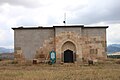
Since the Silk Road from Konya to Beyşehir (roughly today's national road D-330) ran through the northern district, the Seljuks built caravanserais on this route . Four of them are in the Meram district:
- the Dibi Delik Han , built between 1200 and 1210, in Meram
- the Kızılören Han , built around 1205/06, in Kızılören
- the Kızılören Küçük Han , built in the early 13th century, in Kızılören
- the Kuruceşme Han , built between 1207 and 1210, west of Kızılören
(see also the list of the Seljuq Hane in Turkey )
Picture gallery
Kızılören Küçük Han ("little Kizilören Han")

İplikci Mosque in Meram

Dibi Delik Han (also Hocaci Khan, Akbaşhi Khan, Akyokuş Khan) in Meram

Roman bridge in Kilistra

Alavardı Mosque in Yaka

Ataturk House in Meram (now a museum)

Kızılören Han (also Yazıönü Han, Atlı Han, Kızılviran Han, Emir Kandemir Han, Yazonu Han and Yaz Han)
Relief by Hatip with drawing
,_erbaut_Anfang_bis_Mitte_des_13._Jahrhunderts.jpg)
_-_panoramio.jpg)
_erbaut_von_1200_bis_1220.jpg)


,_erbaut_von_1205_bis_1206_von_Emir_Kandehir_unter_Sultan_Kai_Chosrau_I.jpg)

Town twinning
Meram is twinned with:
Mauritania ; Akjoujt , Inchiri Administrative Region , Mauritania![]()
Personalities
- İbrahim Alan , football player
- Abdülkerim Bardakçı , football player
- Mehmet Abdullah Çoban , football player
- Muhammet Yürükuslu , football player
Web links
Individual evidence
- ↑ a b Konya Nüfusu 2018/2019
- ↑ https://meram.bel.tr/tr/icerik/825/3559/dunden-bugune-meram.aspx
- ↑ https://meram.bel.tr/tr/icerik/825/3559/dunden-bugune-meram.aspx
- ↑ According to Law No. 3399, published in the Official Gazette of June 27, 1987; Number 19,500
- ↑ Horst Ehringhaus : Gods, Rulers, Inscriptions - The rock reliefs of the Hittite Empire in Turkey , von Zabern 2005 p. 101 ISBN 3-8053-3469-9
- ↑ Farhaoui, Fouad. "Two Powers Rising in Mauritania: Turkey and China." Mauritania and Newly Emerging Economies in Africa Turkey and China. Np: International Strategic Research Organization, 2013. 46. USAK Report. Web.

Ahırlı | Akören | Akşehir | Altınekin | Beyşehir | Bozkır | Çeltik | Cihanbeyli | Çumra | Derbent | Derebucak | Doğanhisar | Emirgazi | Ereğli | Güneysınır | Hadim | Halkapınar | Hüyük | Ilgın | Kadınhanı | Karapınar | Karatay | Kulu | Meram | Sarayönü | Selçuklu | Seydişehir | Taşkent | Tuzlukçu | Yalıhüyük | Yunak