Nanu (Fatumean)
| Fatumea | ||

|
||

|
||
| Data | ||
| surface | 31.60 km² | |
| population | 831 (2015) | |
| Chefe de Suco | Venancio Madeira Mendonça (election 2009) |
|
| Aldeias | Population (2015) | |
| Halic Nai | 142 | |
| Macocon | 310 | |
| Well | 179 | |
| Tradu Cama | 200 | |
|
|
||
Nanu is an East Timorese place, Aldeia and Suco in the administrative office of Fatumean ( municipality of Cova Lima ). Until 2003 the Suco was called Nano Dakolo .
The place
The place Nanu is the seat of the eponymous sucos. It is located in the north of the Sucos at an altitude of 877 m . There is a primary school in the village.
The Suco
| Fatumea | ||
| places | position | height |
| Buhutaran | 9 ° 17 ′ S , 125 ° 2 ′ E | 681 m |
| Makocon | 9 ° 18 ′ S , 125 ° 3 ′ E | 521 m |
| Well | 9 ° 16 ′ S , 125 ° 2 ′ E | 645 m |
| Tradu Cama | 9 ° 17 ′ S , 125 ° 2 ′ E | 681 m |
831 inhabitants live in Nanu (2015), of which 417 are men and 414 women. The population density is 26.3 inhabitants / km². There are 155 households in the Suco. Almost all residents give Tetum Terik as their mother tongue. A small minority speaks Tetum Prasa .
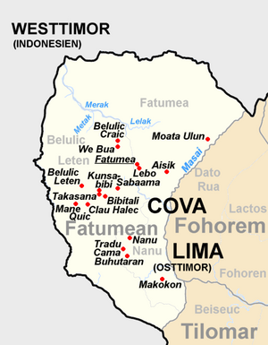
The Suco is located in the south of the administrative office of Fatumean. To the north are the Sucos Belulic Leten and Fatumea , which also belong to the Fatumean administrative office . Across the Masai River , a tributary of the Tafara , to the east is the Fohorem administrative office with its Suco Dato Rua . In the southeast, Nanu borders the Tilomar administrative office with its Suco Beiseuc . In the west lies the border with neighboring Indonesia .
Before the 2015 regional reform, Nanu had an area of 15.52 km², but then received the entire south of the Suco Belulic Leten in the west, so that Nanu now has an area of 31.60 km².
Although the overland road from Fatumea to Tilomar runs from north to south through the Suco, for the parliamentary elections in East Timor in 2007 the ballot boxes had to be brought by helicopter to the polling station at the Sucos headquarters in Nanu and picked up. The villages Nanu, Tradu Cama ( Tradukima , Tradukoma ) and Buhutaran ( Bubularan ) are located on the main road in the northwest of the Sucos . Makokon is located on the banks of the Masai in the southeast .
The four Aldeias Halic Nai , Macocon , Nanu and Tradu Cama are located in the Suco .
history
The empire of Dakolo had its center in Nanu.
politics
In the elections of 2004/2005 was Venancio Madeira Mendonça elected Chefe de Suco and in 2009 re-elected.
Web links
- Results of the 2010 census for the Suco Nanu ( tetum ; PDF; 8.3 MB)
- Results of the 2015 census for the Suco Nanu (tetum; PDF)
- Seeds of Life: Suco information sheets Fatumean (tetum)
Individual evidence
- ↑ a b c d Direcção-Geral de Estatística : Results of the 2015 census , accessed on November 23, 2016.
- ↑ Division of East Timor under the Indonesian administration ( Memento from September 29, 2007 in the Internet Archive )
- ↑ Map in the Cova Lima District Development Plan 2002/2003 ( Memento of October 14, 2013 in the Internet Archive ) (English; PDF file; 2.24 MB)
- ↑ Fallingrain.com: Directory of Cities, Towns, and Regions in East Timor
- ↑ UNMIT: Timor-Leste District Atlas version 02, August 2008 ( Memento from December 3, 2011 in the Internet Archive ) (PDF; 449 kB)
- ↑ Fallingrain.com: Directory of Cities, Towns, and Regions in East Timor
- ↑ Results of the 2010 census for the Suco Nanu ( tetum ; PDF; 8.3 MB)
- ↑ a b Timor-Leste GIS Portal ( Memento from June 30, 2007 in the Internet Archive )
- ↑ Direcção Nacional de Estatística: Population Distribution by Administrative Areas Volume 2 English ( Memento from January 5, 2017 in the Internet Archive ) (Census 2010; PDF; 22.6 MB)
- ↑ List of polling stations for the parliamentary elections in East Timor 2007 (PDF file; 118 kB)
- ↑ Jornal da Républica with the Diploma Ministerial n. 199/09 ( Memento of February 3, 2010 in the Internet Archive ) (Portuguese, PDF file; 315 kB)
- ↑ Suai Media Space: Koba Lima - Suai
- ↑ Secretariado Técnico de Administração Eleitoral STAE: Eleições para Liderança Comunitária 2004/2005 - Resultados ( Memento of August 4, 2010 in the Internet Archive )
- ↑ Secretariado Técnico de Administração Eleitoral STAE: Eleições para Liderança Comunitária 2009 - Resultados ( Memento of August 4, 2010 in the Internet Archive )
