
Nonnendammallee
| Nonnendammallee | |
|---|---|
|
|
|
 |
|
| Southbound carriageway eastwards at Ferdinand-Friedensburg-Platz | |
| Basic data | |
| location | Berlin |
| District | Haselhorst , Siemensstadt |
| Created | 1906–1914, expansion of Nonnendamm |
| Hist. Names | Nonnendamm |
| Name received | April 2, 1914 |
| Connecting roads |
Am Juliusturm (west) , Siemensdamm (east) |
| Cross streets | Daumstrasse (north) , Boltonstrasse (south) , Paulsternstrasse (north) , Otternbuchtstrasse (south) , Rohrdamm, Kapellstieg (north) , Wattstrasse, Grammestrasse, Quellweg, Bödikersteig, Voltastrasse, Wehneltsteig, Reisstrasse (south) , Popitzweg (north) |
| Places | Ferdinand-Friedensburg-Platz, |
| Numbering system | Horseshoe numbering |
| Subway stations | U7 : Haselhorst , Paulsternstraße , Rohrdamm , Siemensdamm |
| use | |
| User groups | Pedestrian traffic , bicycle traffic , car traffic , public transport |
| Technical specifications | |
| Street length | 2720 meters |
The Nonnendammallee is part of one of the oldest streets in Berlin city area and is located in the Spandau district on the historic connection between Spandau and Berlin by Moabit . It belongs to the districts of Haselhorst and Siemensstadt .
The Nonnendammallee is a main street with overriding importance and leads west of the crossing Paulsternstraße in Haselhorst on the street Am Juliusturm in Spandau. The eastern section continues into Siemensdamm with its connection to the A 100 .
Origin of name
The name Nonnendamm (mainly for the eastern section of the route) goes back to the Benedictine convent of St. Marien in Spandau, founded after 1239 and closed in the 16th century . The property of the monastery included areas west of Spandau, which are still fixed in the name of the Spandau location Klosterfelde . Further possessions of the monastery were in the east to Moabit and Wedding . Jungfernheide and Nonnenwiesen were named after the former owners of the area - "virgin" Benedictine nuns.
The name Nonnendamm as a route designation on the southern edge of the Nonnenwiesen was extended to the inhospitable area in the east of Spandau. With the settlement of Siemens plants , especially the settlement of workers, this led to the place name “ Kolonie Nonnendamm b. Berlin ”(from 1914: Siemensstadt). With the expansion of the Siemens company from 1905, the (previously partially) unpaved road in the urban district of Spandau was expanded as a 49-meter-wide "high-quality" street, continuing the Berliner Chaussee to the east, and named after the colony as Nonnendammallee.
story
Development of the traffic route and its connections
The oldest road between Spandau and Berlin, an unpaved road until the beginning of the 20th century, led from the "Berliner Thor" south of the citadel on the north bank of the Spree to Jungfernheide and around the Nonnenwiesen on via Moabit to Spandauer Tor in Berlin. “Within these [Spandau] borders, however, there were areas that did not initially belong to the urban landscape ; These are the Behnitz , the margravial cutting mill located on the same, the monastery mill, the Marienkloster and its possessions, the Götelwiesen and the terrain now occupied by the dam and the Körnersche cutting mill. [...] the Klostermühle, the former properties of the Marienkloster, Klosterhof and Klosterfelde and the Götelwiesen [were] incorporated into the city on October 1st, 1872. “Sometimes only the area of Knüppeldamm is used as Nonnendamm, depending on the source Spandau out, inscribed.
From Spandau, the Berliner Chaussee led from the “Berliner Thor” between the broken pipe and the citadel on the one hand to Sternfeld and north through Haselhorst to Tegel . The way from Paulstern to the east was referred to as the way from / to Spandau or the way from / to Charlottenburg and sometimes as the Nonnendamm. It ran over the elevated terrain on the Sternberg (42 m) and the White Sand Mountains on the southern edge of the Jungfernheide. It was followed by the Nonnendamm through the wetland, the Nonnenwiesen in the north and the unregulated Spree in the south . The bank of the Spree was reached at the site of the old Charlottenburg lock (then: Nonnendamm lock ). To the east the Nonnendamm continued to Moabit, Wedding and Berlin, on the other hand on the Chaussee Tegel – Charlottenburg. "The Spreewiesen in the east of the manor district on Nonnendamm are actually considered to be part of the municipal district, but the official incorporation has not yet taken place." between Faulbaumbusch and the wayside cross on the Spreebogen opposite the castle the name "Nonnendamm". The western connection is the Alte Straße from Charlottenburg , the eastern connection to Eisenham̄er Martinicke on the Spreenordbogen in front of the Judenwiese is unnamed.
The boundaries of the areas belonging to the city of Charlottenburg and the urban district of Spandau ran on Nonnendamm. The Charlottenburg terrain in the east served as meadows, forest and arable land. The Spandau site on the other side of the Havel was largely unused wasteland, increasingly used to expand the Spandau armaments industry to Haselhorst, and the area for the expansion of Siemens' plants.
Nonnendamm Colony

Siemens' production facilities were scattered around Berlin at the end of the 19th century. The fallow area north of the Spree around Nonnendamm belonging to the city of Spandau was selected for a new location . It lay between Nonnenwiesen, Hühner-Werder (since the Spree regulation on their north bank), Rohrbruch and the Jungfernheide and joined the Spandau industrial areas on the terrain of the Haselhorst estate. In 1897, Siemens & Halske AG acquired an area of 209,560 m² on the Hühner-Werder, an "almost uninhabited natural landscape made up of forests, meadows, heathland and wetlands with hardly any traffic facilities". The only transport links to Spandau and neighboring Charlottenburg and Berlin were the waterway on the Spree and the land connection via the (at that time) unpaved Nonnendamm. The first residential buildings in the east of the street and the cross streets (mainly to the south) bear the name "Siedlung Nonnendamm" in their original development.
On the large special map of the area around Berlin from 1905, the Nonnendamm is shown as an improved path on the southern edge of the Nonnenwiesen (dry meadow). To the north along the city and district boundary (Spandau to Charlottenburg) the Nonnendamm continues 500 meters further to the Königsdamm, which is an "easy" route here. A street runs from the Chaussee coming from Spandau, which turns north on the route of Gartenfelder Straße as a road to Tegel. This “marked road” leads around the waterworks in the course of today's Rohrdamm to the south, opposite the stopping point (HP) Fürstenbrunn on the other side of the Spree.
Initially, the Nonnendamm from Charlottenburg was the only “supra-regional” road connection with neighboring towns for the Siemens locations. From 1905 Siemens had the Nonnendamm fortified in the Spandau area. With the construction of the large factories in Siemensstadt from 1906, the "Nonnendamm street" was expanded to a width of 49 meters with the company contributing to the costs. In 1913, the extension to the east in the direction of Moabit was followed by further construction as Siemensdamm through Charlottenburg terrain.
The new route on the historic route to Nonnendamm was renamed "Nonnendammallee" according to a letter from the Spandau police administration to the magistrate on April 2, 1914. In 1914, a section of Nonnendamm was also included in Siemensdamm. Nonnendammallee was already included in the address book in 1915. Before the name developed as Siemensstadt after the main protagonist, the area from Haselhorst to the Charlottenburg border was referred to as "Colony Nonnendamm"; this suburb was first mentioned in the address book in 1910. The Nonnendamm is marked with construction sites between Rohrdamm and the district of Charlottenburg. In the Charlottenburg area in the "Nonnendamm district", the Nonnendamm is entered in the 1910 address book from Tegeler Weg to the Nonnendamm colony, here are residential buildings and factory sites as well as the civil servants' house for the lock administration. There is also the postal address “Nonnenwiese”, which goes off from Nonnendamm. For the city of Charlottenburg, the organizational assignment as a city district is also included in the 1910 address book. The map in the 1910 address book also shows the Spandau area between Sternfeld and “Siemens & Halske Kabelwerk”, which lies in the bend of the Hühnerwerder south of the Old Spree, no parcels on and around the Nonnendamm. To the east of the Charlottenburg terrain, the area (the Nonnenwiesen) between Nonnendamm and Königsdamm (which forms the northern city limits along the Jungfernheide) is parceled out as far as the Tegeler Weg and traversed by planned roads. Already on maps from 1906 and 1907, 3000 hectares in the north of Charlottenburg are marked out and parceled out. Between Spandau, Königsdamm and Tegeler Weg , the “Nonnenwiesen” are affected by projected roads and east of Tegeler Weg to the Plötzensee location, the area between Hamburger Bahn and Hohenzollern Canal.
In the 1911 address book, Nonnendamm is in the "Kolonie Nonnendamm" from the Sternfeld district (Siemens = Schuckert = Werke) via Rohrdamm, Straße 1 , Straße 1a , Brunnenstraße , Straße 2a , Voltastraße, Märkischer Steig , Reisstraße, Hefnersteig, Ohmstraße, Siemensstraße zur District Charlottenburg and back Brunnenstrasse , projected street , Rohrdamm to the district Haselhorst listed. For the district of Charlottenburg, on Nonnendamm between Tegeler Weg and the Nonnendamm colony, there is a plot of land owned by "Bahnhof Jungfernheide Boden AG", the lock management, several inns and, on the opposite side in the direction of Tegeler Weg, the Siemens-Schuckertwerk, a hard stone works, a mortar works, a Branch of the Wernerwerk, the pumping station north of the Spree and the chemical factory of Urban and Lemm.
Siemensstadt
In 1914 “Nonnendamm b. Berlin ”in the urban district of Spandau was named after the factory settlement as“ Siemensstadt ”, which at that time had 7,000 inhabitants and a further 23,000 employees. At the same time as the Siemens settlement, a residential colony of the Prussian military treasury was built in nearby Haselhorst to accommodate the workers of the army canning factory. The electric tram Spandau – Nonnendamm was set up on the new Nonnendamm to connect businesses and residential buildings to Spandau . A further connection of this colony Nonnendamm to the local public transport existed from 1905 over the station Fürstenbrunn on the Hamburger Bahn, but this was removed from the factory halls. Siemens built the Märkischer Steg as a connection from the Fürstenbrunn train station across the Spree at his own expense . In later years, Siemens financed a railway bridge over the Spree to directly connect the area north of the Spree, over which the S-Bahn followed from Jungfernheide to Gartenfeld . The Haselhorst military railway was used for freight traffic and the Siemens freight railway was built with partial guidance on the median of Nonnendamm (from 1914: Nonnendammallee).
Before 1922, the Berlin address book did not contain any information on the city of Spandau. The colony Nonnendamm is included as a separate suburb between 1910 and 1914, whereby the Nonnendamm, but not the Nonnendammallee, is registered. In the 1915 address book there is the entry Siemensstadt in the urban district of Spandau as a suburb of Berlin.
The houses for the Siemens factory employees are in the Nonnenwiesen area to the east of the factory premises. The residential area on Nonnendammallee, as the Nonnendamm housing estate in the Rohrdamm, Jugendweg, Mäckeritzstraße, Ohmstraße and Wernerwerksdamm area was built in the 1910s. This was later followed by the Heimat housing estate in the direction of Jungfernheide and, around 1930, the Siemensstadt housing estate on the Charlottenburg area north of Siemensdamm and in the mid-1950s on Spandauer Flur.
In the 1918 address book, Nonnendammallee for Siemensstadt (Spandau district) is noted. To the west outside of Siemensstadt in the post district Spandau belong the properties 1–59 and 112–175 (consecutive) at Paulstern and Sternfeld in the area of the manor Haselhorst to Nonnendammallee. In Siemensstadt it is taken between Grenzstraße (Spandau-Sternfeld) and Ohmstraße in the Charlottenburg district. On the south side is the sewage treatment plant, followed by the Dynamowerk on Rohrdamm and then (eastwards) the multi-party houses on Watt-, Hertz-, Brunnenstraße, Bödikersteig, Voltastraße, Märkischer Steig, Reisstraße, Hefnersteig, Ohmstraße. On the north side (here indicated to the west) are from Mäckeritzstraße on the district Charlottenburg apartment buildings on Brunnenstraße, Hertzstraße, Wattstraße, Kapellensteig zum Rohrdamm. Plots 101–110 occupy the administration building of Siemens-Schuckert-Werke, No. 111 belongs to the municipality of Spandau. In the district of Charlottenburg, the street Nonnendamm is listed.
Development of Nonnendammallee after 1920

Planning and implementation
Even after the formation of Greater Berlin in 1920 and the inclusion of the city of Spandau as an administrative district, the name of the western continuation of Nonnendammallee past the citadel was retained as Berliner Chaussee . To the east, Siemensdamm is the continuation of Nonnendammallee. Initially it belonged to the city of Charlottenburg and in 1920, with the formation of Greater Berlin, to the administrative district of Charlottenburg. Siemensdamm continues the width of Nonnendammallee for the traffic from Siemensstadt to Charlottenburg and Berlin expected at the time. From the beginning it was designed to relieve the (old) Nonnendamm and leads over Siemensplatz to the eastern Nonnendamm on the Spree, where it connects to the Tegeler Weg. The planning of a “ Charlottenburg-Nord settlement ” on the Nonnenwiesen site included Siemensdamm as the southern main street, with Holtzdamm and Königsdamm following parallel to the north. Housing construction did not begin until after World War II in the 1950s and 1960s. At the same time, the traffic situation and the road connections were changed through the planning and construction of the motorway ring and the northern motorway . The "New Connection Canal ", begun before the war years, was completed, with the Tegeler Weg being laid over the Mörsch Bridge. The road construction changed the location from Siemensdamm to Nonnendamm.
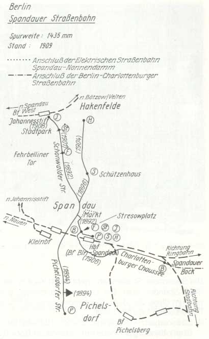
In 1925, the Siemens freight railway is available along the length of Nonnendammallee to Rohrdamm and to Siemens & Halske and Schuckertwerke on the district border of Charlottenburg. She avoids the housing estate in the east. The Spandau – Nonnendamm (-Charlottenburg) tram runs on the Berliner Brücke ( Juliusturmbrücke ) over the Havel and on the Berliner Chaussee (Am Juliusturm) through Haselhorst on Gartenfelder Strasse with a branch to the cable works. The further rail route goes over the Schwarzen Weg (Paulsternstraße) to the Nonnendammallee and on this to the district border. In Charlottenburg, the train arrives on Nonnendamm along the lock canal to Tegeler Weg at Jungfernheide station and finally (later connected) to Moabit.
Development according to the city map
On the map from 1921, Nonnendamm is drawn to the east along the Spandau / Charlottenburg district border and in Charlottenburg along the lock canal to Tegeler Weg to the north of the railway line. In the administrative district of Spandau, the Nonnendammallee ends at the district border from Spandau, from there the (projected) Siemensdamm leads over Siemensplatz to Tegeler Weg through the “Charlottenburg-Nord” residential area on the Nonnenwiesen between Spree and Jungfernheide , which was planned and parceled out before the First World War . The map from 1926 shows a similar distribution, with the expanded Siemens factories adjoining Nonnendamm. Siemensstrasse now leads from Rohrdamm via Brunnenstrasse and Reisstrasse to Nonnendamm. In 1932, part of the Wernerwerk was located south of the newly created Wernerwerk S-Bahn station, east of Nonnendamm in the Charlottenburg area. According to the card, Nonnendamm is no longer connected to Nonnendammallee. The (remaining) Nonnendamm is connected to Rohrdamm and Nonnendammallee via Siemensstraße at the southern end of the residential streets in eastern Siemensstadt. In addition, Nonnendammallee has been shortened in favor of Siemensdamm, which now leads into Siemensstadt. The district boundary at Nonnendamm, which was changed in 1938, is entered on the map from 1943, so that part of Nonnendamm with the Wernerwerk premises belongs entirely to Siemensstadt. On the maps from 1943 and 1946, Siemensstrasse was renamed Schwiebertstrasse in the same course (up to Nonnendamm) . In 1954, the end of the Nonnendamm has a western connection to the Tegeler Weg and the planned tour to the previous connection point and the (newly named) Old Tegeler Weg. This route change is the result of the extension of the Westhafen Canal over the Charlottenburg connecting canal directly to the Spree. The western connection of the Nonnendamm takes place in the route of the Siemensstraße , which is now called Wernerwerksdamm . With the completion of the "New Connection Canal", which ran up to the Teltower Weg as early as 1943, the Nonnendamm is connected to the Tegeler Weg under the Mörschbrücke in the east . There is still a 15-meter-wide section of Siemensdamm that meets Nonnendamm 130 meters east of the lock. This street complements the Nonnendamm running on the Spree as a direct connection between Nonnendammallee and Tegeler Weg and lowers the importance of the Nonnendamm as a street. At that time, the new course of the Tegeler Weg from Siemensplatz to the new bridge structure for the connecting canal was built. The map from 1960 shows the completed “connecting canal” and the “projected” route of the city motorway into the Gördeler Damm. The motorway was led with the north-west arch bridge over the Nonnendamm without affecting it. In 1961, the section between the aforementioned bridge to Gördeler Damm has not yet been completed.
Situation since the 1960s

The Nonnendammallee is classified in the Berlin street directory as a higher-level street connection (Category II in the StEP). It is located between Siemensdamm in the east with a connection to the motorway city ring and the A 111 and the street Am Juliusturm in the west with a connection to the Spandau town center. The house number sequence follows the principle of horseshoe numbering . The course of the road between Daumstrasse at Ferdinand-Friedensburg-Platz and including the intersection with Paulsternstrasse (Otternbuchtstrasse) and lots 1–37 and 128–175 (continuous) belongs to the Spandau district of Haselhorst. The section to the east between Paulsternstrasse and Jungfernheideweg / Reisstrasse with lots 41–123 (continuous) belongs to Siemensstadt. The street (almost) belongs to the districts according to the postcodes 13599 (Haselhorst) and 13629 (Siemensstadt). With the Berlin street number 3260 it belongs to the RBS class “STRA” and in the expansion conditions it belongs to the OKSTRA class “G” as a municipal road. The distance between the endpoints of the street ( Nonnendammallee to Am Juliusturm , 35 m above sea level , Nonnendammallee on Siemensdamm , 34 m above sea level ) is 2720 meters, as it largely consists of two separate lanes, and the length is in the detailed network of the regional reference system 3730 meters listed.
The coordinates of the middle of the street lengths are in the western part of the district ( Nonnendammallee in Haselhorst ) and in the eastern part in Siemensstadt ( Nonnendammallee in Siemensstadt ). The street is served by BVG bus lines and the underground line U7 runs under it , from which the underground stations Siemensdamm , Rohrdamm , Paulsternstraße and Haselhorst are located on Nonnendammallee.
To the east, the street is surrounded by the residential buildings from the founding time around 1910; to the west of the Rohrdamm, industrial and commercial sites, most of which belong to Siemens companies, define the street scene. The track systems of the Siemens freight railway were located on the median to Paulsternstrasse. The tracks from "Bahnhof Nonnendammallee" are still between Daumstrasse and Paulsternstrasse.
The main thoroughfare from Charlottenburg to Spandau is wide and has four lanes in each direction. Due to the heavy traffic, pedestrians can often only cross it at the traffic lights. At the eastern end there are some residential buildings with small shops, industrial buildings follow from Rohrdamm westwards. The Siemens company with its numerous subsidiaries is the most important resident of the street. Until the construction of Nonnendammallee, a section of Nonnendamm (from 1906) and the construction of Siemensdamm (from 1913), the connection between Siemensstadt and Siemens and Berlin was the Nonnendamm . In 1905 Spandau paved road 45 (a section of Nonnendamm) with a 5.5 meter wide cobblestone pavement, some of which is still present in the eastern area. On April 2, 1914, the Spandau police administration sent a letter to the magistrate stating that the Nonnendamm will be referred to as Nonnendamm- Allee after its expansion into the (then) Spandau area . In 1906, Siemens provided road 43 ( Holtzdamm , in the Popitzweg area ) on its site with a concrete roadway. Until 1925, the actual Nonnendamm ran diagonally across the grounds of the Wernerwerk high-rise building and led to Siemensdamm at Ohmstrasse. The Siemens freight railway is located on Nonnendammallee. Its track bed and installed overhead lines for the systems of this electrically operated railway were renewed in 1985/1986 shortly before the switch to diesel operation. Siemens companies and industrial and commercial companies that have been re-used are located between Rohrdamm and Paulsternstraße. In the Haselhorster section there are industrial and commercial companies on the south side, for example the tax office. There are trading markets on the north side and the Knobelsdorff School (" OSZ Bau und Holztechnik") is located in Nonnendammallee 140-143 .
- Nonnendammallee

1986: Nonnendammallee station in Berlin

Corner of Paulsternstrasse in Haselhorst

Level crossing in the direction of Reuter power station, corner of Boltonstrasse
Siemens headquarters: Nonnendammallee 101

Residential complex Nonnendamm-Nord (corner of Reisstrasse / Jungfernheideweg)

.jpg)


Striking buildings on Nonnendammallee
Under the influence of the decisive company in this part of Spandau, a closed architecture with several architectural monuments was created at the beginning of the 20th century, which are recorded in the list of cultural monuments in Berlin-Siemensstadt .
- Nonnendammallee 72: Siemens Dynamowerk . It was built in 1906 by Karl Janisch and Carl Dihlmann and expanded by Janisch in 1909–1912, and in 1922 and 1938–1942 by Hertlein.
- Nonnendammallee 97: tenement (Grammestrasse 11, Wattstrasse 5) It was created 1910–1911 by Bruno Taut and Franz Hoffmann . The facade is characterized by corner projections on the street side and delicate wooden balconies, the three-story plastered building has a hipped roof with a loft.
- Nonnendammallee 80 / 81a: Nonnendamm I residential complex (south) of the Charlottenburg building cooperative
- Nonnendammallee 89–93b: Nonnendamm-Nord residential complex of the Charlottenburg building cooperative
- Nonnendammallee 101: In December 1913, employees of the Siemens group moved to their headquarters in the Siemens main building. The total construction cost was 4.5 million marks . In 1909 the east wing of the metal-reinforced brick building was raised, and from 1912 it was expanded to meet the company's rapidly increasing space requirements. On a built-up area of 10,250 m², an office building complex was built with over 191,000 cubic meters of enclosed space and 77,000 m² of usable space. The building provided space for the central administration, the management and the boardroom with representative rooms from Siemens, including the mosaic hall. The building planning came from Karl Janisch .
- Nonnendammallee 101 at the corner of Rohrdamm: memorial in 1934, the memorial was erected by Hans Hertlein and Josef Wackerle to commemorate the 3,000 Siemens employees who died in the First World War. In 1970 the memorial was expanded to include a memorial for the workers who died in the Second World War.
- Nonnendammallee 104: Siemens-Schuckert-Werke, Schaltwerk high-rise and hall building. Hall D was built in 1916 for aircraft construction by Karl Janisch. From 1919 it was used as a switchgear, followed by the north and east buildings (1921–1922). The switchgear complex is to the west of the Siemens administration building. The "Elektropolis" Berlin is represented with illustrations as a symbol of modernity.
- Nonnendammallee 108: Siemens factories, surge current test facility. The surge current test system was used to test high-voltage circuit breakers. The building, designed by Hans Hertlein in 1927, is designed as a shell for the technical systems and was expanded several times until the 1950s. The purpose-oriented design is the specialty of this building.
- Nonnendammallee 111: Siemens factories, high-voltage test field with parabolic hall and laboratory building. The high-voltage test field was designed by Walter Henn in 1958–1959 as an extension of the neighboring surge current test facility. The facility consists of a building block with laboratories and workshops as well as a 25 meter high parabolic hall.
- Nonnendammallee 140: Knobelsdorff school "OSZ BAU I" This building houses the vocational school in the field of construction technology, vocational school for building craftsmen, technical college and vocational high school. The building was erected in 1986 to combine construction training, over 6000 schoolchildren and around 280 teachers are organizationally united under one roof.
- U-Bahn construction along Nonnendammallee. The route ran between Popitzweg under Nonnendammallee, in Haselhorst under the southern lane to Spandau. In 1980 the section to the Rohrdamm was opened, in 1984 the section to the end point in the old town of Spandau.
On Nonnendammallee, history can be seen in various monuments.
- On Nonnendammallee (50 meters east of Berliner Allee, later Gartenfelder Straße) there was a monument erected by the Guard Grenadier Regiment No. 5 from a 90 centimeter high, unprocessed boulder. Inscription: “Waldemar / Plehn / Major u. Bat. Commander / i. Guard Grenadier Regt. N.5. / Cross / January 15, 1898 ". This officer fell from his horse and died. The whereabouts of the monument is unknown. In 1925 it was feared that the monument would be destroyed by the pending road construction.
- World War I Memorial Hospital Victims 1914–1918: The memorial donated by the Siemens company was originally located in the abandoned Haselhorst cemetery on Nonnendammallee. In 1961 the war victims were reburied in Section 51 in the “In den Kisseln” cemetery. The memorial, which was restored in 1985 with a donation from Siemens, is located in the field of honor for the victims of the First World War who died in the Siemensstadt military hospital.
- Memorial to the fallen of Siemenswerke: The monument in the form of a sunken courtyard to commemorate the Siemens employees who died in the two world wars is located on the forecourt of the Siemens main building; the lower memorial plaza is accessible via six steps from Nonnendammallee . The first plans from 1921 were not completed. After a competition designed by Hans Hertlein, it was inaugurated on August 5, 1934 by Carl Friedrich von Siemens. On three of the four walls of the courtyard, the names of all 2989 fallen soldiers are listed on 118 cast-iron plates, sorted according to years of war. On the southwestern edge of the enclosure rises a 16-meter-high rectangular stele made of shell limestone with the year 1914, an oak leaf, the year 1918 and underneath an iron cross. On the pillar sits a 2.5 meter high eagle (bronze) with a wingspan of 3.30 meters. The sword and eagle on the memorial are the work of Joseph Wackerle .
- Plaque in memory of the forced laborers used at Siemens in World War II
- Memorial for Siemens employees who died in World War II: In 1970, the memorial in the inner courtyard of the Siemens administration building was extended to designs by Berlin architect Karl Heinrich Schwennicke (1901–1985). For each war year, a white monolithic cube made of artificial stone was placed on the side. A memorial plaque unveiled on November 21, 2011 will commemorate the more than 40,000 people who had to do forced labor in Spandau's factories during the Nazi era . At Nonnendammallee 128, the Haselhorst-Süd residential camp of the Siemens company was located, a sub-camp of the concentration camp . In 1994 the Siemens company had the entire memorial restored.
Web links
- Nonnendammallee. In: Street name dictionary of the Luisenstädtischer Bildungsverein (near Kaupert )
- The industrial estate "Spandau-Nonnendamm" becomes "Siemensstadt"
- List of cultural monuments in Berlin-Siemensstadt
- Properties on Nonnendammallee , accessed on June 2, 2015.
- Address search Nonnendammallee. Geoportal Berlin; accessed June 2, 2015
Remarks
- ↑ A district of Nonnendamm in the city of Charlottenburg was created west of the Spandau district for the settlement of Siemens workers. “As early as 1899, Siemens had been considering a 'residential colony' for its employees at the new location, but it had failed due to resistance from Charlottenburg and Spandau (Charlottenburg feared the 'urban sprawl' of its posh residential area Westend and Spandau follow-up costs); In mid-1904, Spandau then issued the settlement permit. Märkische Bodengesellschaft, working on behalf of Siemens, developed the area made available by the company and began building the first apartment blocks between Ohmstrasse, Hefnersteig and Reisstrasse with freelance architects and builders in the autumn of 1904. | Source = Karl-H. Bienek: Die Siemensstadt ”, accessed May 1, 2015, on diegeschichteberlins.de
- ↑ The card does not contain a year. The Spree has been straightened, the cable plant is noted.
- ↑ The path name Nonnendamm for the Spandau section is not used uniformly in the sources, but is ultimately fixed as Nonnendamm "allee".
- ↑ On March 16, 1908, the Siemens company opened a freight railway in Siemensstadt, Nonnendammallee, with a length of 20 kilometers, which was connected to the Spandau – Insel Eisfeld freight railway.
- ↑ From a letter from the Spandau Police Administration to the Magistrate of the city of Spandau on April 2, 1914, it can be seen that the continuation of the Nonnendamm to the west after the expansion in the Spandau area at that time is already known as Nonnendamm-Allee (later: Nonnendammallee). The addition of “Allee” was intended to reflect the generous expansion of the street. quoted from Nonnendammallee. In: Street name dictionary of the Luisenstädtischer Bildungsverein (near Kaupert )
- ↑ Article-related street, express and works railway links , accessed on May 1, 2015.
- ↑ berliner-bahnen.de: Trams from Spandau
- ↑ stadtschnellbahn-berlin.de: The Siemens line
Individual evidence
- ↑ see Spandauer Viertel in JGA Ludwig Helling (Hrsg.): History-statistical-topographical pocket book of Berlin and its nearest surroundings . HAW Logier, Berlin 1830. Online at books.google.de, accessed May 1, 2015.
- ↑ a b Surroundings of Berlin. Publishing house Bibliographisches Institut in Leipzig: Charlottenburg around 1894 ( page no longer available , search in web archives ) Info: The link was automatically marked as defective. Please check the link according to the instructions and then remove this notice. , accessed May 1, 2015, at alt-berlin.info.
- ↑ a b O. Kuntzemüller: Documented history of the city and fortress Spandau . P. 30, accessed on May 1, 2015.
- ^ Yearbook for Brandenburg State History, Volume 51, p. 66, Landesgeschichtl. Association, 2001 : “As these are obsolete and now unknown names; This is how the izo of the city of Gränen is called: Towards morning it borders in front of the Berlin Gate with the Royal Office behind the golden star as far as the Nonnendamm and goes around the border to the right through the aforementioned water, called the crowel or crewel (which is an arm is what the Havel does) […] ”, accessed May 1, 2015.
- ^ Philipp Frank: Theodor Fontane and the technology . Page 158 : “At the end of the 1890s, the company relocated to a meadow land on the Unterspree, the Nonnendamm, where Siemensstadt was built in the following years.” Retrieved on May 1, 2015.
- ^ Alfred Mende (Geograph.-Lithograph. Institute): Large traffic plan Berlin and its suburbs (city map 1907) , accessed on May 1, 2015.
- ^ History of Berlin: Siemensstadt , accessed on May 1, 2015.
- ↑ Digitized version of the ZLB: eld_zlb-bsk-12243884DS1.pdf, accessed May 1, 2015.
- ^ History of Berlin: Siemensstadt, accessed May 1, 2015, on diegeschichteberlins.de
- ^ Pharus Plan Berlin . Charlottenburg around 1906. ( Page no longer available , search in web archives ) Info: The link was automatically marked as defective. Please check the link according to the instructions and then remove this notice. , accessed May 1, 2015, at alt-berlin.info
- ↑ Large transport plan for Berlin and its suburbs . Designed and drawn by Alfred Mende in Berlin, Geogr.-Lithogr. Institute
- ↑ On October 1, 1908, Siemens started tram operations on the Breite Straße / Havelstraße-Nonnendamm / Reisstraße route. For this purpose, the independent company "Elektro Straßenbahn Spandau - Nonnendamm GmbH" was formed on July 1, 1908.
- ^ Siemensstadt . In: Berliner Adreßbuch , 1918, V., p. 820.
- ^ Association for the History of Berlin (founded 1865): Berlin and Spandau in their mutual relationships , accessed on May 1, 2015.
- ^ Charlottenburg around 1926 on the Berlin Sanwald Plan . Verlag Karl Sanwald / Pasing in front of Munich ( page no longer available , search in web archives ) Info: The link was automatically marked as defective. Please check the link according to the instructions and then remove this notice. , accessed May 1, 2015
- ^ Charlottenburg around 1932 on Westermann's plan of Berlin . Verlag Georg Westermann, Berlin W 40 / Braunschweig ( page no longer available , search in web archives ) Info: The link was automatically marked as defective. Please check the link according to the instructions and then remove this notice. , accessed May 1, 2015.
- ^ Arne Hengsbach: 75 years of Siemens freight railways . In: Communications of the Association for the History of Berlin (PDF) accessed May 1, 2015.
- ↑ Spandau Tram 1909 , accessed on May 1, 2015.
- ↑ History of the Berlin trams , accessed on May 1, 2015.
- ↑ Pharus Plan Berlin (large edition with suburbs). Pharus Verlag GmbH / Berlin SW 68 / Linden-Strasse 3: Siemensstadt around 1921 ( page no longer available , search in web archives ) Info: The link was automatically marked as defective. Please check the link according to the instructions and then remove this notice. , accessed May 1, 2015.
- ^ Pharus Plan Berlin. Pharus Verlag GmbH / Berlin SW 68 / Linden-Strasse 3: Charlottenburg around 1906 ( page no longer available , search in web archives ) Info: The link was automatically marked as defective. Please check the link according to the instructions and then remove this notice. , accessed May 1, 2015.
- ↑ a b Sanwald Plan Berlin. Verlag Karl Sanwald / Pasing in front of Munich: Siemensstadt around 1926 ( page no longer available , search in web archives ) Info: The link was automatically marked as defective. Please check the link according to the instructions and then remove this notice. , accessed May 1, 2015.
- ^ Westermann's plan of Berlin . Verlag Georg Westermann / Berlin W 40 / Braunschweig: Siemensstadt around 1932 ( page no longer available , search in web archives ) Info: The link was automatically marked as defective. Please check the link according to the instructions and then remove this notice. , accessed May 1, 2015.
- ^ Pharus plan Berlin. PHARUS-PLAN publishing house, Berlin N 54, Schwedter Straße 263: Siemensstadt around 1943 ( page no longer available , search in web archives ) Info: The link was automatically marked as defective. Please check the link according to the instructions and then remove this notice. , accessed May 1, 2015.
- ↑ City map of Berlin . Richard Schwarz, Landkartenhandlung and Geogr. Verlag, Berlin W.35: Charlottenburg around 1946 ( page no longer available , search in web archives ) Info: The link was automatically marked as defective. Please check the link according to the instructions and then remove this notice. , accessed May 1, 2015.
- ↑ Pharus City Map Berlin Large Edition . Pharus-Plan-Verlag in Treuhand / Berlin N 54 / Schwedter Straße 263: Charlottenburg around 1954 ( page no longer available , search in web archives ) Info: The link was automatically marked as defective. Please check the link according to the instructions and then remove this notice. , accessed May 1, 2015
- ↑ Pharus City Map Berlin Large Edition . Pharus-Plan-Verlag in Treuhand / Berlin N54 / Schwedter Straße 263: Siemensstadt around 1954 ( page no longer available , search in web archives ) Info: The link was automatically marked as defective. Please check the link according to the instructions and then remove this notice. , accessed May 1, 2015.
- ↑ For the condition of the Nonnendamm see the aerial photo from January 1943 on Google Earth with the central coordinate 52 ° 31 ′ 52.45 ″ N and 13 ° 17 ′ 12.21 ″ E: Location of the Nonnendamm in 1943 between Siemensbahn and (old) Tegeler Weg
- ↑ VEB Map Publisher Berlin: Book Plan for Berlin (1955), accessed on May 1, 2015.
- ↑ see Google Earth, map from December 1953: NS = 52 ° 31'54.70 "N and EW = 13 ° 17'31.94" E - confluence Siemens- / Nonnendamm (1953)
- ↑ Berlin city map 1961 , accessed on May 1, 2015.
- ↑ Berlin with sector boundaries. Verlag Richard Schwarz Nachf .: Charlottenburg around 1960 ( page no longer available , search in web archives ) Info: The link was automatically marked as defective. Please check the link according to the instructions and then remove this notice. , accessed May 1, 2015
- ↑ Large Berlin city map. Publishing house Richard Schwarz Nachf. / Berlin W 30 / Lützowstraße 32: Charlottenburg around 1961
- ↑ Nonnendammallee. In: Street name dictionary of the Luisenstädtischer Bildungsverein (near Kaupert )
- ↑ Address search Nonnendamm in the national maps with parcel boundaries, street names and property numbers; produced by the land surveying offices of the twelve districts on the basis of the ALK-Berlin (automated real estate map). , accessed May 1, 2015
- ^ Nonnendammallee in Berlin-Siemensstadt, accessed on May 1, 2015.
- ↑ Knobelsdorff School , accessed on May 1, 2015.
- ↑ January 1, 1914 - The “Spandau-Nonnendamm” industrial estate becomes “Siemensstadt” , accessed on May 1, 2015.
- ↑ Entry in the Berlin State Monument List
- ↑ Entry in the Berlin State Monument List
- ↑ Entry in the Berlin State Monument List
- ↑ Entry in the Berlin State Monument List
- ↑ Entry in the Berlin State Monument List
- ↑ Headquarters building in Berlin-Siemensstadt celebrates its 100th birthday . December 6, 2013, with photo gallery
- ↑ Entry in the Berlin State Monument List
- ↑ Entry in the Berlin State Monument List
- ↑ Entry in the Berlin State Monument List
- ↑ Entry in the Berlin State Monument List
- ^ Dachverband Lehm: Working group for the Knobelsdorff School
- ↑ books.google: Noah Adomait: The longest tunnels in the world: monuments and structures of our earth
Address book receipts
- ^ Supplement to the Berlin address book 1915 . In: Berliner Adreßbuch , 1915, supplement, p. 35. “Nonnendamm, Charlottenburg, Postamt 1, (F / G 8/9/10); Nonnendammallee, Spandau-Siemensstadt, 60–110, Post Siemensstadt near Berlin, 1–59 and 111–175 Post Spandau (F 6/7/8) ”, accessed May 1, 2015.
- ↑ Nonnendamm Colony . In: Berliner Adreßbuch , 1910. "Colony Nonnendamm (Stadtkreis Spandau) Inhabitants 1325"., Accessed May 1, 2015
- ^ Nonnendamm (Nonnendamm colony, Spandau district) . In: Berliner Adreßbuch , 1910. “/ ← Rohrdamm → / ← Strasse 1 → / ← Strasse 1a → / ← Brunnenstrasse 2a → / ← Voltastrasse → / ← Markischer Steig → / ← Reisstrasse → / ← Hefnersteig → / ← Ohmstrasse → / ← Siemensstrasse → / ← District Charlottenburg → / ← Rohrdamm → “., Accessed May 1, 2015
- ^ Nonnendamm (Charlottenburg, Charlottenburg district) . In: Berliner Adreßbuch , 1910. "/ ← Tegeler Weg → / Wünsche'sches Haus, Stätteplatz, Jungfernheide Boden Akt.Ges., Construction sites, office of the lock administration with the Nonnendamm lock office, construction sites, gardening, construction sites / ← Nonnendamm colony → / Construction sites, Mann's house, Berl property. Hard stone works, construction sites, Ulrich's house: with seven residents (heads of household), Automobil Ges. Faltin & Co, Berl. Steam boiler factory R. Bernau & Co., Möbelfabrik Schulz & Co., Sparmotorwerke Gödele & Schellmann, as well as a branch of Siemens & Halske Wernerwerk AG, pumping station north of the Spree in the city of Charlottenburg, Stätteplatz of the city of Charlottenburg, Urban- & Lemmsche's house with six heads of household (Works manager, authorized signatory, machinist, coachman, the widow L. Lemm and the innkeeper Guggenberger) as well as the chemical factory Urban & Lemm, construction sites / ← Tegeler Weg → “., Accessed May 1, 2015
- ↑ Nonnenwiese . In: Berliner Adreßbuch , 1910. “/ ← Nonnendamm → / Barth's house with five residents, Jacob's house: which is managed by the fattening owner J. Rietz and in which the coachman and the fodder are named as residents, air bath“ Nüpi "Of the sanatorium owner G. Kätzle, who lives in the Wünsche'schen house on Nonnendamm.", Accessed May 1, 2015.
- ↑ Nonnendamm and Nonnenwiese . In: Berliner Adreßbuch , 1910. "City district: Nonnendamm, community orphanage district: 11a, poor commission: 7, police station: 12, registry office: 3, medical district: 13, post office: Charlottenburg 1"., Accessed May 1, 2015
- ^ Map of Charlottenburg, including Nonnendamm and Königsdamm . In: Berliner Adreßbuch , 1910., accessed May 1, 2015
- ^ Nonnendamm in the urban district of Spandau (Nonnendamm colony) . In: Berliner Adreßbuch , 1911, V., p. 349. “(Gemarkung Sternfeld) / property of the Siemens-Schuckert-Werke (E: Siemens-Schuckert-Werke) / d. Building cooperative Charlottenburg (E: Charlottenburger Baugenossensch EGmbH, V: Ingenieur R. Bieneck, 28 tenants) / (Rohrdamm) / Construction sites / (Street 1) / Construction sites / (Street 1a) / Construction sites / Kühne'sches Haus (E: Construction company P. Kühne from Brunnenstrasse, nine tenants and T.) / (Brunnenstrasse) / construction sites / (Strasse 2a) / construction sites / (Voltastrasse) / new building (E: Zimmerstrasse O. Plamann from Voltastrasse 5) / (Märkischer Steig) / (Reisstrasse) / (Hefnersteig) / construction site / (Ohmstraße) / construction sites / (Siemensstraße) / construction sites // district Charlottenburg // construction sites / Hertling'sches Haus (E: forwarder E. Hertling from Charlottenburg, T: forwarding company F. Bennendorf Nachf.) / Construction sites / (Brunnenstrasse) / Construction sites / new building (E: Ms. E. v. Voss from Berlin) / (Project. Street) / Rudat'sches Haus (E: Baugesch. D. Rudat, nine tenants) / (Rohrdamm) / Construction sites / Administrative building d. Siemens-Schuckert-Werke (E: Siemens-Schuckert-Werke) / construction sites (Haselhorst district) ”, accessed May 1, 2015
- ^ Nonnendamm in Charlottenburg . In: Berliner Adreßbuch , 1911, part V., p. 117. "(Tegeler Weg) / Wünsche'sches Haus (E: City of Charlottenburg, seven tenants) / Stätteplatz (E: Jungfernheide Boden station act. Ges.) / Construction sites / Official house of the lock administration (E: Fiskus, Bureau der Nonnendammschleuse, Schleusengeldhebestelle, Schleusenmstr. K. Bischoff, Schleusenverwalt. W. Kirbach) / construction sites / Scheider'sches Haus (E: innkeeper F. Hinz) / gardening / construction sites / Streu'sches Haus (E: Schankwirt C. Streu) / Construction sites / Mann'sches Haus (E: Rentier W. Mann from Christstr. 17, V: Schankwirt J. Frisch) // (Colony Nonnendamm) // Siemens-Schuckertwerke (go z. Colony Nonnendamm) / construction sites / property of the Berl. Hartstein-Werke (E: Berliner Hartsteinwerke GmbH, V: Werkführer R. Borgemann, Kalksandsteinfabrik Dalchow & Haukelt) / Property of the mortar works Nonnendamm (E: Forwarder Hertling from Sophie-Charlotten-Straße 16) / Construction sites / Ulrich'sches Haus (E : Kfm M. Ulrich from Düsseldorf, architect G. Ulrich from Spandauer Strasse 16 and Kfm. E. Ulrich from Schloßstrasse 18; nine tenants and a branch Siemens & Halske Wernerwerk AG) / Pumpwerk nordl. D. Spree (E: City of Charlottenburg, V: Maschinenmstr. C. Horsche from Magazinstraße 17) / Stätteplatz (E: City of Charlottenburg) / Urban & Lemm'sches Haus (E: factory owner O. Lemm from Gatow aH, T: innkeeper J. Guggenberger, T: Chem. Factory Urban & Lemm; tenants: widow L. Lemm, coachman Th. Masloff, machinist O. Nordwig, authorized signatory E. Opitz, factory manager F. Stift) / construction sites / (Tegeler Weg) ” May 1, 2015.
- ↑ Nonnendamm Colony . In: Berliner Adreßbuch , 1914., accessed May 1, 2015.
- ^ Siemensstadt . In: Berliner Adreßbuch , 1915., accessed May 1, 2015.
- ^ Nonnendammallee in Siemensstadt . In: Berliner Adreßbuch , 1918, V, p. 822. “1-49 go to Post District Spandau / (Grenzstrasse) / 60.61 sewage treatment plant / 62-79 (E: Siemens-Schuckert-Werke) Dynamowerke d. Siemens-Schuckert-Werke, Apprenticeship School of the Siemens-Schuckert-Werke, Wärme-Verwert.Ges.mbH / (Rohrdamm) / Residential houses (E. Charlottenbg. Baugenossenschaft EGmbH), 80: seven tenants, 81: eight tenants, 81a: Business Association Siemensstadt and 13 tenants / (Wattstrasse) / residential houses (as well as Hertzstrasse 12 and Wattstrasse 4; E: Schlossermstrasse C. Hille), 82: seven tenants, 82a: eight tenants / (Hertzstrasse) / 83 (see also Brunnenstrasse 17 and Hertzstrasse 5; E: Widow A. Düker) / (Brunnenstrasse) / 84, 84a (see also Bödikersteig 7 and Brunnenstrasse 10; E: Bauuntern. P. Kühne) / (Bödikersteig) / 85 (see Bödikersteig 5, 6 and Voltastr. 7,8; E: Mrs. A. Mack from Lichterfelde, eight tenants), 85a (see also Bödikersteig 5, 6 and Voltastr. 7,8; E: Märkische Bodengesellschaft mbH, four tenants) / ( Voltastraße) / 86 (see also Märkischer Steig 7 and Voltastr. 6; E: Märkische Bodengesellschaft mbH, 14 tenants) / (Märkischer Steig) / 87, 87a (see also Märkischer Steig 6 and Reisstr. 21; E. Ms. A. Schwack from Berlin, 15 tenants) / (Reisstrasse) / Residential building (s. a. Hefnersteig 7 and Reisstr. 20; E: Building contractor H. Boll), 88: eight tenants, 88a: eleven tenants / (Hefnersteig) / building sites / (Ohmstraße) // district Charlottenburg // - (Mäckeritzstraße) / apartment buildings (E. Charlottenbg. Baugenossenschaft EGmbH), 89: six tenants, 90: eight tenants, 91: seven tenants, 92: Wirtschaftsverein Siemensstadt and six tenants, 92a: nine tenants, 92b: ten tenants, 92c: seven tenants, 92d: five tenants, 92e: eleven tenants, 92f: eight tenants , 93: eight tenants, 93a: six tenants, 93b: eight tenants / (Brunnenstrasse) / apartment buildings (E: Architect K. Tilgner from no. 96), 94: 13 tenants, 95: sa Halskesteig 2, municipal registry office II and five tenants, 96: see a. Halskesteig 1, five tenants / (Hertzstrasse) / 97 (see also Hertzstrasse 11 and Wattstrasse 5; E: Nonnendamm Grundstück-GmbH, sister home d. Siemens-Schuckertwerke and eight tenants) / (Wattstrasse) / 98: see a. Kapellensteig 1 and Wattstrasse 12; E: Kfm. O. Prager from Spandau, ten tenants / (Kapellensteig) / apartment buildings: 99 see a. Jungfernsteig 2 (E: owner Hafner), 13 tenants; 100 s. A. Jungfernsteig 1 (E: Bauunternehmer A. Rudat), twelve tenants / (Rohrdamm) / 101-110 Verwaltungsgeb. d.Siemens-Schuckert-Werke (E: Siemens-Schuckert-Werke, V: Administrator H. Redlich), T: Siemens & Halske AG. Finance department, T: Siemens Elektr. Betriebe Aktiengesellsch., T: Siemens'sche Familienbesitz-Verwaltg. GmbH; Siemens-Schuckertwerke department for electrical railways, Siemens-Schuckertwerke department for industry, Siemens-Schuckertwerke department for small products, Siemens-Schuckertwerke department for central offices, Siemens-Schuckertwerke finance department, heat recovery. Ges.mbH / 111: E: City of Spandau, V: Pol.Wachtmstr. F. Bohm, tenant: lantern keeper F. Fredyk, locksmith G. Kaboth, regulator keeper R.Neumann / (Grenzstraße) / 112-175 geh.z. Post label Spandau ”., Accessed May 1, 2015
- ^ Nonnendamm in Charlottenburg . In: Berliner Adreßbuch , 1918, V. Teil, p. 636 (The demarcation of Nonnendammallee and Nonnendamm is in 1918 (before the formation of Greater Berlin) on the border between the Charlottenburg district of Nonnendamm and Siemensstadt in the urban district of Spandau May 1, 2015
Coordinates: 52 ° 31'53.1 " N , 13 ° 16'51.7" E