
Eastern Slovakia

The eastern Slovakia (Slovak Východné Slovensko ) is the traditional name of the eastern third of Slovakia .
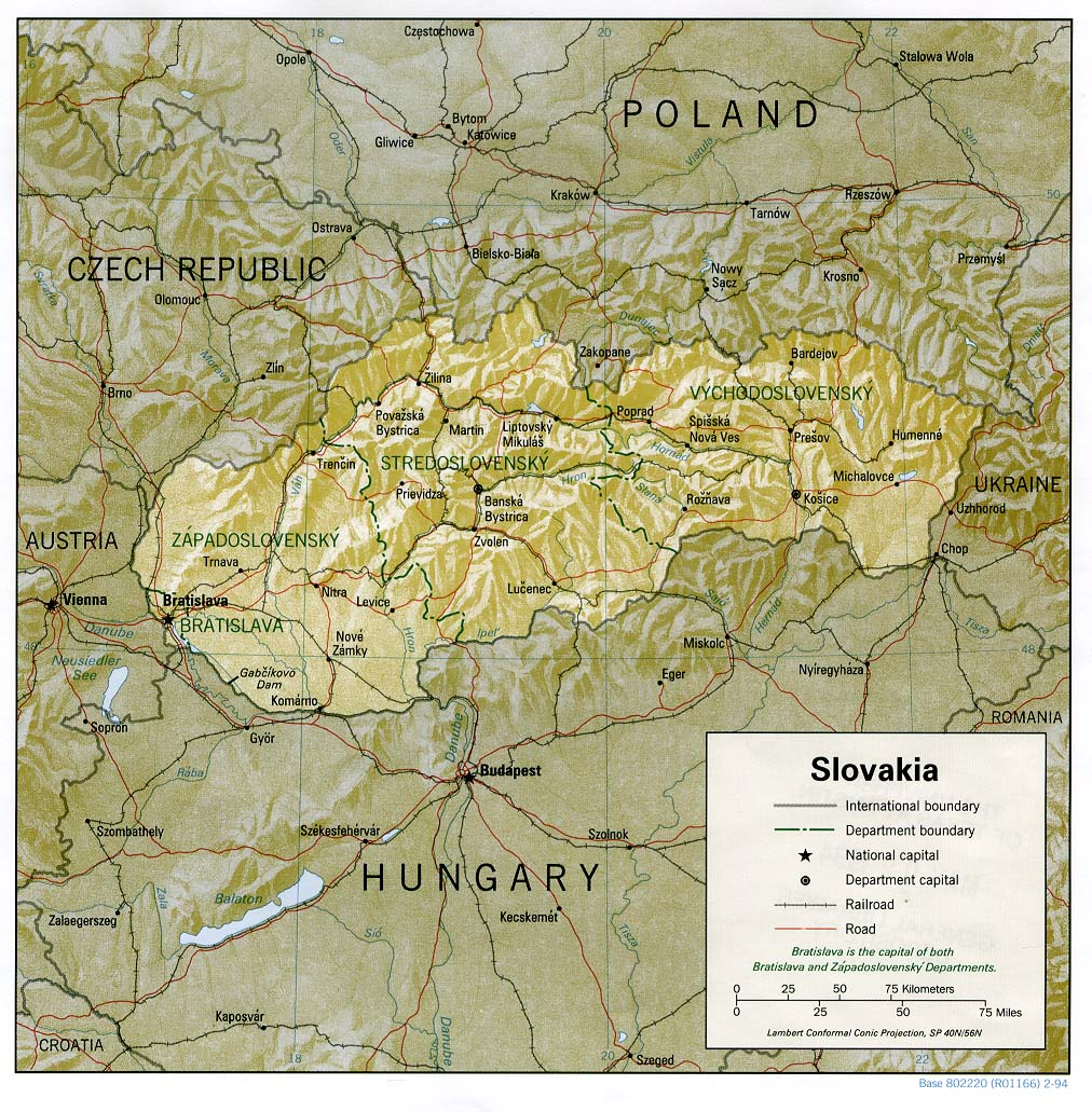
From 1960 to 1990, there was a special Region Východoslovenský kraj (Ostslowakischer Region) that is approximately the territory of the two municipal associations Prešovský kraj and Košický kraj corresponded. Today eastern Slovakia is no longer an independent administrative or other district. However, there is an East Slovak "region" ( Východné Slovensko ) for statistical purposes of the EU ( NUTS 2 at Eurostat ), which corresponds to the area of Košický kraj and Prešovský kraj.
The area borders with Poland in the north, Ukraine in the east and Hungary in the south.
Climate, mountains, rivers

The climate is predominantly continental with dry, hot summers and humid, cold winters. At higher altitudes there is snow 130 days a year. At lower altitudes the January temperature is just below zero, in July and August daily averages of 30 ° can be exceeded. The region east of Košice towards Ukraine is characterized by particularly long sunshine of up to 2,200 hours a year .
Geomorphologically, the dividing line between the Western Carpathians and the Eastern Carpathians runs roughly at Bardejov . In the south-east is the East Slovak Plain (sometimes called "Lower Semplin "), which has heights of 90 to 100 m nm , but some small areas are even below sea level. Except for the area around the Poprad River, Eastern Slovakia drains into the Eastern Slovakian Plain.
In eastern Slovakia there are high mountains (the High Tatras ) and many low mountain ranges ( for example the eastern part of the Slovak Ore Mountains , Levočské vrchy (German: Leutschauer Berge) and the volcanic Vihorlat Mountains with 1000 to 1500 m).
The main rivers are the Poprad , the Torysa , the Hornád , the Ondava , the Latorica . The Bodrog is created by the confluence of the latter two rivers . The Hornád, which comes from the Low Tatras and curves in a long curve to the south, flows in terraced steps under the old town of Košice and flows into the Tisza after about 300 km at the Hungarian Miskolc .
Characteristic

The largest city in eastern Slovakia is Košice , which is by far the second largest city in the country. It has numerous high schools and several universities such as B. Pavol Jozef Šafárik University and Prešov , the second largest city in the region and third largest in Slovakia, has a lot to offer for students and visitors. The third largest city in the region is Bardejov in the north with charming surroundings and a well-preserved Renaissance- style city center .
There are still a few Russians and Ukrainians living in the north-east of Eastern Slovakia, a Magyar minority in the south and numerous Roma throughout Eastern Slovakia who are more affected by unemployment than the rest of the population. The Roma now live in particular in the former Spiš .
Many areas of Eastern Slovakia are among the most backward in Slovakia in every respect. This has various historical causes, but today, after the collapse of communism in 1989, it is mainly due to the frequent (still) lack of transport links with the more advanced western Slovakia. A motorway connection , the D1 motorway , is under construction, but since the motorway from Budapest to Miskolc is expected to be completed earlier due to the lack of mountain ranges, the Hungarian motorway will probably be the shortest connection between the Slovak capital Bratislava and the Slovak second city for a few years Be Košice .
Tourism is also only slowly gaining momentum due to the long traffic routes, although eastern Slovakia - like all of Slovakia - beautiful landscapes, old towns, the High Tatras (which, however, is often already regarded as central Slovakia) and the famous bathing lakes Zemplínska šírava and Veľká Domaša offers.
history
In the history of the Kingdom of Hungary , of which it was part from the end of the 11th century (southern parts) or the beginning of the 14th century (northern parts), Eastern Slovakia has always been a more or less special area with Košice as de facto - capital.
The border of the main area of the Principality of Neutra ended probably somewhere near Košice in the 11th century. The border of the archdiocese of Esztergom , which existed for centuries in the Middle Ages and comprised western and central Slovakia, ended roughly where eastern Slovakia begins. In the 16th and 17th centuries, eastern Slovakia and the neighboring areas were finally referred to as " Upper Hungary ". Some of the Eastern Slovak dialects are also difficult to understand for other Slovaks.
Geology and mining

In central and eastern Slovakia you can find lignite , small amounts of iron ore , non-ferrous metals (especially copper ), manganese and antimony ore . Mercury, lead and zinc are also mined, salt in several places , and the good quality of dolomite and brick clay is used .
Economy and industry
Agricultural land approx. 30%, larger industrial settlements can be found near Košice, Michalovce, Prešov and Poprad.
See also
- List of cities in Slovakia , List of rivers in Slovakia
- List of traditional regions of Slovakia
- Eastern Slovak dialects
- Administrative division of Slovakia
- Central Slovakia
- Western Slovakia