
Karagandy (area)
|
Karagandy Region Қарағанды облысы Карагандинская область |
||
|
||
| Basic data | ||
|---|---|---|
| State : |
|
|
| Administrative headquarters : | Karagandy | |
| Founded: | March 10, 1932 | |
| Area : | 427,982 km² | |
| Residents : | 1,376,882 (Jan 1, 2020) | |
| Population density : | 3 inhabitants per km² | |
| Time zone : | EKST ( UTC + 6 ) | |
| Postal code : | 10xxxx | |
| Telephone code : | +7 (721) | |
| License plate : | 09 (old: M, K) | |
| KATO code: | 350000000 | |
| ISO 3166-2 : | KZ-KAR | |
| Äkim ( governor ) : | Schengis Qassymbek | |
| Website : | ||
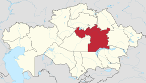
| Location in Kazakhstan | ||
  |
||

The Karagandy Region ( Kazakh Қарағанды облысы / Qaraghandy oblysy , Russian Карагандинская область / Karagandinskaja Oblast ) is the largest administrative unit of Kazakhstan and is located in the center of the country. The capital of the region is the city of Karaganda (Russian Karaganda ).
geography
The territory of Karagandy coincides geographically with the Kazakh Threshold ( Saryarka ). Only in the south is the plateau of the Hunger Steppe ( Betpak-Dala ) and in the south-west the Mujunkum desert . While the northern rayons (Kazakh. Ауданы / Audany ) of the area are located in the steppe zone , the semi-desert takes up the greater part in the middle, the south and southwest already belong to the desert kingdom . The Karagandy region borders in the north with the regions of Qostanai , Aqmola and Pavlodar ; in the east to the region of East Kazakhstan ; in the south to the areas of Almaty , Shambyl , Turkistan and Qysylorda and in the west to the area of Aktobe .
The highest mountain ranges in the area include Karkaraly , Kysyltas and Ulutau . The highest mountain is Aksorantau in the Karkaraly massif of the Kazakh threshold with almost 1566 m . The longest rivers are Sarysu (800 km) and Nura (978 km), plus Sherubai-Nura , Kara-Kengir , Kulskutpes and Tokrau . In general this area is rather barren and dry. Almost all rivers are the steppe rivers without drainage and which often dry out in midsummer, similar to the Australian creeks. Only the Nura River has water all year round. There are two large lakes on the territory of the Karagandy Territory, Lake Balkhash and Lake Tengiz . With an area of 18,000 km² on average, the Balkhash is one of the largest lakes in the world. In 1973 the Irtysh-Karagandy Canal was put into operation, through which 600 million cubic meters of water passes annually.
history
In prehistoric times, numerous nomadic khanates existed in the area; it is considered the ancient domain of the Kazakhs . From the Middle Ages to the early modern period the area was called Desht-i-Kipchak - Kipchak Steppes .
In the 19th century this territory came to the Russian Empire , which established some fortresses here such as Karkaralinsk and Ulutavskij. At the end of the century, hard coal of the highest quality was found not far from the Nura River , and since then the Qaraghandy basin has become one of the world's most important hard coal deposits.
The Karagandy region was created on March 10, 1932, but its center was initially Petropavlovsk . In 1936 the capital was moved to Karagandy. During this period, there were numerous Gulag camps on the territory of the area with the administrative center in Dolinka , where millions of people had to work in inhumane conditions, including some prominent dissidents such as Alexander Solzhenitsyn and Lev Kopelev .
After the war the area gained further importance. In 1973 that part of the area south of the Karagandy Basin was attached to the newly formed Sheqazghan area. In 1992, a rayon in the Aqmola area was given to Karagandy. In 1997 the Sheqasghan area was reverted to Karagandy.
population
Ethnic groups
| Ethnic group | VZ 1989 | VZ 1999 | VZ 2009 | |||
|---|---|---|---|---|---|---|
| number | % | number | % | number | % | |
| Kazakhs | 449,837 | 25.77% | 529.478 | 37.55% | 622.265 | 46.40% |
| Russians | 817,900 | 46.86% | 614.416 | 43.57% | 529.961 | 39.51% |
| Ukrainians | 128,547 | 7.36% | 78,755 | 5.58% | 49,969 | 3.73% |
| German | 159.208 | 9.12% | 57,229 | 4.06% | 32,787 | 2.44% |
| Tatars | 52,769 | 3.02% | 39,313 | 2.79% | 32,730 | 2.44% |
| Belarusians | 35,731 | 2.05% | 21,579 | 1.53% | 13,370 | 1.00% |
| Korean | 14,672 | 0.84% | 14.097 | 1.00% | 13,354 | 1.00% |
| Chechens | 5997 | 0.34% | 4660 | 0.33% | 5099 | 0.38% |
| Azerbaijanis | 4787 | 0.27% | 3667 | 0.26% | 4122 | 0.31% |
| Poland | 7239 | 0.41% | 5572 | 0.40% | 3982 | 0.30% |
| Other | 68,761 | 3.94% | 41,452 | 2.94% | 38,667 | 2.88% |
Population development
The population of the Karagandy area as of January 1, 2020 was around 1.38 million people, placing it in fourth place in Kazakhstan in terms of population. The area reached its highest population level in the Soviet census in 1989, when the Karaganda Oblast in its present borders had a population of just under 1.85 million. After Kazakhstan declared its independence from the Soviet Union, the Karagandy area suffered a decline in population. The number of residents decreased by more than 400,000 people within ten years, which corresponds to a decrease of almost 25 percent. The whole of Kazakhstan experienced a decline in population in the 1990s, but the population loss was greater in the northern areas of the country than in other parts of the country.
|
|
|
|
 |
¹ census result
Politics and administration
Administrative division
The area is divided into nine districts ( Kazakh Ауданы Audany ; Russian Район Rajon ) and nine urban districts (munizipale, self-governing). In total there are eleven cities and 38 settlements with 1,000 to 10,000 inhabitants in the Karagandy area. The largest are: Agadyr , Aqtau , Aqtas , Atassu , Shachan and Shairem . The rural region is divided into 168 Aul districts at the lowest level .

| Audany | Area [km²] | Residents | Administrative headquarters |
|---|---|---|---|
| Abai | 6,725 | 58,949 | Abai |
| Aqtoghai | 51,997 | 17,331 | Aqtoghai |
| Balqash (city) | 5,916 | 79.191 | Balqash |
| Buqar-Schyrau | 14,403 | 56,908 | Botaqara |
| Nura | 46,326 | 22,314 | Kievka |
| Osakarov | 11,261 | 30,870 | Osakarowka |
| Priosersk (city) | 55 | 13,295 | Priosersk |
| Karagandy (city) | 498 | 497,954 | Karagandy |
| Qaraschal (city) | 792 | 18,586 | Qaraschal |
| Qarqaraly | 35,472 | 35,410 | Qarqaraly |
| Saran (city) | 161 | 52.010 | Saran |
| Satbayev (city) | 1.104 | 69,953 | Satbayev |
| Shakhtinsk (city) | 236 | 56,986 | Shakhtinsk |
| Shangaarqa | 62,348 | 34,522 | Atassu |
| Sheqasghan (city) | 1,761 | 91.904 | Sheqasghan |
| Schet | 65,695 | 41,993 | Aqsu-Ajuly |
| Temirtau (city) | 302 | 186.080 | Temirtau |
| Ulytau | 122.930 | 12,626 | Ulytau |
| As of January 1, 2020 | |||
Äkim (governor)
List of governors ( Kazakh Әкім , Äkim ) of the Karagandy Oblast since 1992:
| No. | Surname | Term of office (beginning) | Term of office (end) |
|---|---|---|---|
| 1 | Pyotr Nefjodov | 1992 | 1997 |
| 2 | Maschit Esenbayev | July 1997 | October 1999 |
| 3 | Kamaltun Muchamedzhanov | October 1999 | January 19, 2006 |
| 4th | Nurlan Nyghmatulin | January 19, 2006 | November 19, 2009 |
| 5 | Serik Akhmetov | November 19, 2009 | January 20, 2012 |
| 6th | Äbilghasy Qusaiynow | January 20, 2012 | January 28, 2013 |
| 7th | Bauyrshan Abbdishev | January 29, 2013 | 20th June 2014 |
| 8th | Nurmuchambet Abdibekov | 20th June 2014 | March 14, 2017 |
| 9 | Jerlan Qoshanov | March 14, 2017 | 18th September 2019 |
| 10 | Schengis Qassymbek | 19th September 2019 | officiating |
economy
The agglomeration around the city of Karagandy used to be one of the most important industrial areas of the Soviet Union . Qaraghandy is still the second most important industrial location in Kazakhstan after Almaty . Above all, the huge coal deposits of Karabass have secured it this status. In Sheqasghan and Balqash there are large works for the smelting of non-ferrous metals , mainly copper , and iron is mined in the area around Temirtau and Qaraschal . In these cities there are also factories for processing the metals, such as the goldsmith's with a jewelry factory in Balqasch, which was built in 2004, or the copper wire factory in Schesqasghan. The other branches of industry are mechanical engineering in Karagandy, chemical industry in Temirtau and the food industry in almost all larger cities.
In the vast steppe and semi-desert areas , cattle breeding , especially sheep breeding, is strongly developed. In the north, cattle and pigs are also kept and wheat is grown. Vegetables are grown everywhere around the cities; especially of potatoes. There are occasional small sunflower plantations and orchards.
Web links
Individual evidence
- ↑ Численность населения Республики Казахстан по полу в разрезе областей и столицы, столицы, столицы, анколицы, столицы, городоав, областей и столицы, анкония, горойцы, коники, городоав,. ( Excel ; 96 KB) stat.gov.kz, accessed on July 19, 2020 (Russian).
- ↑ pop-stat.mashke.org: Ethnic composition: 1989 census (data for regions) , accessed June 24, 2017 (Russian).
- ↑ pop-stat.mashke.org: Ethnic composition: 1999 census (data for regions) , accessed June 24, 2017 (Russian).
- ↑ pop-stat.mashke.org: Ethnic composition: 2009 census , accessed June 24, 2017 (Russian).
| Areas |
Almaty | Aqmola | Aqtobe | Atyrau | Mangghystau | North Kazakhstan | East Kazakhstan | Pavlodar | Karaganda | Qostanai | Qysylorda | Shambyl | Turkistan | Western Kazakhstan |
|
| Cities with special status |
Coordinates: 48 ° 0 ' N , 71 ° 0' E