
Randegg
|
market community Randegg
|
||
|---|---|---|
| coat of arms | Austria map | |
 |
|
|
| Basic data | ||
| Country: | Austria | |
| State : | Lower Austria | |
| Political District : | Scheibbs | |
| License plate : | SB | |
| Surface: | 51.82 km² | |
| Coordinates : | 48 ° 1 ′ N , 14 ° 58 ′ E | |
| Height : | 366 m above sea level A. | |
| Residents : | 1,877 (January 1, 2020) | |
| Population density : | 36 inhabitants per km² | |
| Postal code : | 3263 | |
| Area code : | 07487 | |
| Community code : | 3 20 09 | |
| NUTS region | AT121 | |
| Address of the municipal administration: |
Randegg 22 3263 Randegg |
|
| Website: | ||
| politics | ||
| Mayor : | Claudia Fuchsluger ( ÖVP ) | |
|
Municipal Council : ( 2020 ) (19 members) |
||
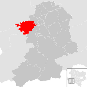
| Location of Randegg in the Scheibbs district | ||
  |
||
 Municipal Office |
||
| Source: Municipal data from Statistics Austria | ||

Randegg is a market town with 1877 inhabitants (as of January 1, 2020) in the Scheibbs district in Lower Austria .
geography
Randegg is located in the Mostviertel in Eisenwurzen in Lower Austria . The area of the market town covers 51.87 square kilometers. 38.87 percent of the area is forested.
climate
|
Average monthly temperatures and precipitation for Randegg
|
|||||||||||||||||||||||||||||||||||||||||||||||||||||||||||||||||||||||||||||||||||||||||||||||||||||||||||||||||||||||||||||||||||||||||||||||||||||||||||||||||||||||||
Community structure
The municipal area comprises the following 10 localities (population in brackets as of January 1, 2020):
- Franzenreith (105)
- Trench (57)
- Hinterleiten (114)
- Hochkoglberg (149)
- Mitterberg (119)
- Perwarth (399)
- Puchberg near Randegg (251)
- Randegg (349)
- Schliefau (184)
- Stonewood (150)
On May 1, 1965, the communities of Franzenreith, Hochkoglberg, Perwarth and Puchberg were incorporated into Randegg near Randegg.
The community consists of the cadastral communities Franzenreith, Hochkoglberg, Perwarth, Puchberg bei Randegg, Randegg and Steinholz.
Neighboring communities
| Neuhofen an der Ybbs ( Amstetten district ) | Euratsfeld ( Amstetten district ) | Wang |
.svg)
|
||
| Waidhofen an der Ybbs (statutory city) | Ybbsitz ( Amstetten district ) | Gresten Land |
history

Even before the Roman occupation, Randegg was known as the Celtic settlement of rand-e-ack. In ancient times, the area was part of the Noricum province .
From the end of the 10th century Randegg was a fiefdom of the bishops of Freising . The late Gothic parish church dates from the 13th century. In 1848 today's political community was established.
On April 15, 1945, 100 Jewish forced laborers were murdered in Randegg by members of the SS and the Hitler Youth. A memorial stone with the inscription "To commemorate the 100 concentration camp victims in April 1945" was erected in 1980 as a reminder.
Population development
According to the results of the 2001 census, there were 1934 inhabitants. In 1991 the market town had 1872 inhabitants, in 1981 1842 and in 1971 1837 inhabitants.
politics
The municipal council has 19 members.
- With the municipal council elections in Lower Austria in 1990, the municipal council had the following distribution: 15 ÖVP, 2 SPÖ and 2 citizen lists Randegg Aktiv.
- With the municipal elections in Lower Austria in 1995, the municipal council had the following distribution: 16 ÖVP, 2 SPÖ and 1 citizen list Randegg Aktiv.
- With the municipal council elections in Lower Austria in 2000, the municipal council had the following distribution: 13 ÖVP, 4 Dallhammer list, 1 SPÖ and 1 Randegg Aktiv list of citizens.
- With the municipal council elections in Lower Austria in 2005 , the municipal council had the following distribution: 12 ÖVP, 4 List Dallhammer and 3 SPÖ.
- With the municipal council elections in Lower Austria in 2010 , the municipal council had the following distribution: 14 ÖVP, 3 the really necessary bourgeois community model (DENBGM) and 2 SPÖ.
- With the municipal council elections in Lower Austria in 2015 , the municipal council had the following distribution: 15 ÖVP, 3 SPÖ and 1 FPÖ.
- With the municipal council elections in Lower Austria 2020 , the municipal council has the following distribution: 17 ÖVP and 2 SPÖ.
- mayor
- until 2010 Engelbert Wieser (ÖVP)
- since 2010 Claudia Fuchsluger (ÖVP)
Culture and sights
- Meridian stone: Not far from Randegg - in the neighboring municipality of Gresten-Land - the 15th eastern longitude intersects with the 48th northern latitude. A meridian stone has been erected at this point.
- Bike path / herb garden
- Experimental together with the partner village Randegg (Gottmadingen)
economy
In 2001 there were 54 non-agricultural workplaces, agricultural and forestry operations 182 according to the 1999 survey. According to the 2001 census, the number of people in employment at the place of residence was 898. In 2001, the activity rate was 47.93 percent.
Personalities
- Honorary citizen of the community
- Former Mayor Engelbert Wieser
Web links
- Side of the community
- Entry about the Randegg castle ruins on Lower Austria Burgen online - Institute for Reality Studies of the Middle Ages and Early Modern Times, University of Salzburg
- Entry via Randegg Manor on Burgen-Austria
- 32009 - Randegg. Community data, Statistics Austria .
- Entry about Perwarth Castle Ruins in Lower Austria Castles online - Institute for Reality Studies of the Middle Ages and Early Modern Times, University of Salzburg
Individual evidence
- ↑ Statistics Austria: Population on January 1st, 2020 by locality (area status on January 1st, 2020) , ( CSV )
- ^ Klaus-Dieter Mulley: National Socialism in the Political District Scheibbs 1930-1945 (= local history of the district Scheibbs 8) . Scheibbs 1988.
- ^ Heinz Arnberger / Claudia Kuretsidis-Haider (eds.): Commemoration and dunning in Lower Austria. Reminder signs of resistance, persecution, exile and liberation . 2011.
- ^ Result of the local council election 1995 in Randegg. Office of the Lower Austrian State Government, March 30, 2000, accessed on October 12, 2019 .
- ^ Election result of the municipal council election 2000 in Randegg. Office of the Lower Austrian State Government, February 4, 2005, accessed on October 12, 2019 .
- ^ Election result of the local council election 2005 in Randegg. Office of the Lower Austrian State Government, March 4, 2005, accessed on October 12, 2019 .
- ^ Election result of the local council election 2010 in Randegg. Office of the Lower Austrian State Government, October 8, 2010, accessed on October 12, 2019 .
- ^ Election results for the 2015 municipal council elections in Randegg. Office of the Lower Austrian State Government, December 1, 2015, accessed on October 12, 2019 .
- ↑ Results of the local council election 2020 in Randegg. Office of the Lower Austrian state government, January 26, 2020, accessed on February 29, 2020 .


Cadastral communities: Franzenreith | Hochkoglberg | Perwarth | Puchberg near Randegg | Randegg | Stone wood
Locations: Franzenreith | Dig | Hinterleiten | Hochkoglberg | Mitterberg | Perwarth | Puchberg near Randegg | Randegg | Schliefau | Stone wood
Market place: Randegg Villages: Perwarth | Schliefau Weiler: Fünfhaus Scattered Houses: Franzenreith | Dig | Hinterleiten | Hochkoglberg | Mitterberg | Perwarth surroundings | Puchberg near Randegg | Schliefau surroundings Other locations: Perwarth ruins
Counting district: Randegg | Puchberg near Randegg | Hochkoglberg | Perwarth | Franzenreith