
Red island
The Red Island , also Schöneberger island called, is a town located in the Berlin district of Schöneberg . Since the district reform of 2001 it has belonged to the seventh Berlin district of Tempelhof-Schöneberg , but it is not itself an official administrative unit.
The quarter emerged from its island location between different train tracks and traditionally showed a “red” - that is, a more politically left - orientation of its population. The Queen Luise Memorial Church from 1912 and the striking Schöneberg Gasometer - the industrial monument dominates the entire Rote Insel as an architectural landmark .

location


The Rote Insel lies on the Teltow ridge south of the Berlin-Warsaw glacial valley . The coordinates are 52 ° 29 ' N , 13 ° 22' E (centered on the Queen Luise Memorial Church on Gustav-Müller-Platz). The postcode of the residential area is 10829.
In the cityscape of today's Berlin
The district is located on the southern edge of the city center within a striking acute-angled triangle, the sides of which are formed by the tracks of the Wannseebahn in the west, the Dresden or Anhalter Bahn in the east and the Ringbahn in the south. The cornerstones are the stations of the Berlin S-Bahn : Schöneberg , Südkreuz and Yorckstraße . The latter name has two different, but only about 300 meters apart, train stations, of which the one with the addition Großgörschenstraße is on the Wannseebahn.
In the west, the former center of Schöneberg borders the Rote Insel ( Kaiser-Wilhelm-Platz and Hauptstraße - the former village meadow ). The district of Kreuzberg joins in the northeast, and residential areas to the east and southeast, some of which already belong to the Tempelhof district .
In addition to the actual "island location" between the railroad tracks, the adjacent streets in Schöneberg and Kreuzberg are also included in the Red Island. For example, the office of the party Die Linke in Feurigstrasse calls itself the “Rote Insel office”. The streets adjacent to the northern tip of the island around the Yorckstraße train station also count themselves to the Red Island, although they are geographically outside this area. One example is the squatted house on Mansteinstrasse, whose residents maintain the myth of the Red Island to this day with graffiti campaigns , parties and political events.
The central Insel-Kiez
Two streets cross the Rote Insel as the main axes in a west-east direction: the (smaller) Monumentstrasse and the Kolonnenstrasse, which were the main shopping street in the area until the 1980s.
The streets south of Kolonnenstrasse and west of Naumannstrasse traditionally form the actual core of the neighborhood . These five streets parallel and in north-south direction are (from west to east) the Cherusker, Goten, Leber, Gustav-Müller and Naumannstrasse. These are only crossed by smaller streets, the Leuthener and Torgauer Straße and the Roßbachstraße, which is only a few meters long.
Today it is no longer immediately recognizable that the roads outside this core were only felt to be part of the island to a limited extent until the end of the Second World War . However, the buildings that looked like completely normal Wilhelminian-style residential buildings, such as those in Czeminskistraße (formerly Siegfriedstraße ) or Hohenfriedbergstraße, were often the seat of small offices for military or other government agencies or accommodation for members of the military. The actual resident population of the northern island was therefore rather small for a long time, strongly fluctuating and quite incoherent ; there was no basis for the emergence of the “ neighborhood ” social fabric that shaped the southern part early on.
Northern tip
The Alte St. Matthäus-Kirchhof , located in the northern tip of the triangle, illustrates the geological location of the Rote Insel on the Teltow plateau with its gently sloping terrain towards the Berlin glacial valley, i.e. towards the Spree valley . The churchyard is located as an offshoot of the island on the Teltowhang, which - as the adjacent map from 1875 can still clearly see - continues to the east in Kreuzberg and Hasenheide . In this residential area in the valley (below the Teltow plateau, around Katzlerstrasse), which from the rest of the island through the cemetery on the one hand and the barracks area of III. On the other hand, the Railway Pioneer Regiment was separated, August Bebel also lived after it was established in 1890 . However, his house in Großgörschenstrasse is no longer there. Today there is a small playground there.
topography


by Hans Baluschek (1918).
The painting shows the south-western part of the island, where the Ringbahn and Wannsee Railway meet
The railway lines that make up the island triangle are almost completely drawn on the historical map from 1877. The area of the island itself - exactly in the lettering " Alt von Alt-Schöneberg" - was still undeveloped at that time.
Schöneberg, which experienced a rapid development from a rural rural community to an independent town during the 19th century , offers a particularly vivid example of a phenomenon that was recognizable throughout Europe in the settlement history of the industrial age .
Two very different residential areas were developed from the old Schöneberg town center around 1900: the noble Bavarian quarter with its extensive recreational facilities such as the adjacent Rudolph-Wilde-Park in the west, but in the east, between farms, factories and the "two railways [...] with its uninterrupted roar and the coal haze polluting the air ”(according to Max Schasler 1868), the future working-class district of Schöneberg.
The quotation cited indicates why the residential areas of the common people in the up-and-coming industrial cities of Europe almost always came to be in the east: In Europe, the predominant wind direction is west and in the exhaust plumes and the noise of the booming cities, the population that settled couldn't afford anything better or healthier.
About the origin of the name
"Island"
The described location of the Kiez - " enclosed by routes " - has played an important role in its development, both historically and sociologically. At the beginning of the coordinated development measures around 1870–1890 in this part of the then still independent city of Schöneberg, the railway lines laid out in the second third of the 19th century acted as an unplanned obstacle to the development.
Only in the late Imperial Era between the turn of the 20th century and the First World War did the transport links to Alt-Schöneberg and Berlin improve . This was partly due to the rapid growth of the capital into the surrounding area, and partly to the fact that the northern and eastern parts of the island were used intensively by the Prussian military .
A total of four bridges have connected the Rote Insel with the city since the early 20th century: Julius-Leber-Brücke (formerly: Sedan-Brücke ) and Langenscheidtbrücke (formerly: Siegfried-Brücke ) to the west and thus Alt- and Neu-Schöneberg as well as monuments - and Kolonnenbrücke to the east in the direction of Kreuzberg or Tempelhof.
In 1901, at the height of today's Julius-Leber-Brücke, a station was built under the name Schöneberg on the Südringpitzkehre from Potsdam station to the Ringbahn , which had a small station building with a characteristic turret. The trains on the main line or the Wannseebahn did not stop there. It was the first train station to be named Schöneberg . With the renaming of the Ebersstrasse station at the intersection of the Ring- and Wannseebahn to Berlin-Schöneberg , it was renamed Kolonnenstrasse . The station was operated until 1944 and was not put back into operation after the war. The building was demolished after the Second World War . Since 1985 there have been plans for an S-Bahn station on the Wannseebahn in this area, but these were not implemented until 2008. On May 2, 2008, the new Julius-Leber-Brücke S-Bahn station with two outer platforms went into operation. In the long term, a re-establishment of the connection to the Ringbahn is being considered in the last expansion stage of the S21 project , at which a stop will also be set up in this area.
Originally there were two tram lines on the island (25, later renamed to 2), which stopped operating in the 1960s. Today's bus lines 104 (formerly: Line 4), 106 and 204 (formerly: 23) largely follow the same route on the island as the former tram lines.
Furthermore, east of today's Naumannstrasse on the southern branch of Kolonnenstrasse, located directly on the Dresden Railway, there was a military station since the imperial era (completed in 1874/1875). This had little meaning for the population of the island. It is of historical interest because the military railway in the direction of Zossen , Sperenberg and Jüterbog to the military training areas and the army research facility began here. After the Austro-Prussian War in 1866, Prussia recognized the importance of the railroad for troop movement and supplies and therefore set up its own railroad regiments that were to be trained in the operation and construction of the lines and bridges. During the First World War , part of the troop transports from the capital departed from here, but due to the relatively small capacities of the Schöneberg military station, the other Berlin stations were also involved. The ruin of the station was demolished in 1955.
"Red"
The following anecdote bears features of a big city myth , but explains why the island was given the attribute "red":
"When in 1878 - the SPD was banned by the Socialist Law at the time - Kaiser Wilhelm I returned to Berlin after two assassinations from a cure lasting several months and the city sank into" Hurray patriotism "and a sea of black, white and red flags, the Schöneberg beer publisher Bäcker from Sedanstrasse [note: name of today's Leberstrasse until 1937] hung the red flag out of the window. For this outrageous act he was expelled from the country. The Sedan quarter was from then on the Red Island called. "

Even at the time of its creation, the island was a residential area of the "little people". After the socialist law was abolished in 1890, the SPD was able to achieve an unusually high percentage of votes in this part of Schöneberg.
The population of the island suffered further noticeable social decline in the wake of the inflation after the First World War . In the years of the Weimar Republic there was therefore a high proportion of “red” voters (SPD, USPD , KPD ) and - due to the officers' families of the railway regiment - German national parties.
In the suppression of the Kapp Putsch of 1920, during which dramatic events took place around the old Schöneberg town hall on Kaiser-Wilhelm-Platz , the “left” population of the Red Island played an important role. A memorial plaque at the location of the old town hall today commemorates the victims.
In the same year the island, like all of Schöneberg, was incorporated into Greater Berlin . Compared to the large working-class districts of the capital such as “Roten Wedding ”, Neukölln or Friedrichshain , the more upscale and still suburban Schöneberg looked rather modest. Nevertheless, until the end of the Weimar Republic, the SA only dared to venture heavily armed, like a raid and in large troops into the area of the island dominated by sympathizers of left parties.

Julius Leber , one of the leading political figures in the resistance fighters of July 20, 1944 , worked camouflaged during the war years in a coal shop on Torgauer Strasse (opposite the confluence with Gotenstrasse). The former Sedan Street and Bridge are named after him today.
Since the beginning of the 1980s, the voting behavior of the “islanders” has changed insofar as the Greens in the Kiez often achieve voting shares of well over 20 percent.
Other names of the district
In the boom period following the establishment of the empire in 1871, Sedanstrasse was the first road on the island to be developed, laid out, built on and settled as planned. Because of this primacy one spoke of the "Sedanviertel" until around the Second World War .
The Sedanstraße was on the instructions of the Nazi party in 1937 in Franz Kopp Street renamed - by an SA man who was shot dead on March 30, 1933 on the territory of the Red Island. It was only renamed for the few years until 1945. Since then, the street has been called Leberstraße. However, neither of these names had any influence on the naming of the neighborhood.
architecture
The gasometer

→ See main article: Gasometer Schöneberg
The most striking landmark on the Red Island and its architectural landmark is the giant gasometer built in 1910 . It is over 50 meters high and was originally able to store up to 160,000 m³ of town gas , which at the time was used to illuminate streets and apartments as well as for heating and cooking. The gas plant was operated by the British Imperial Continental Gas Association (ICGA), but was expropriated as early as 1916. During the First World War, they wanted to keep this vital company in exclusive German ownership.

Until it was shut down in 1993, the gasometer was more of a thorn in the side of the “Rotinsulans”, which is partly understandable, since the huge facility “displaced air and sun” for the residents. Contrary to many fears, catastrophic explosions never occurred while the gasometer was in operation. The extent to which there are long-term consequences for people and the environment that can be directly traced back to the toxic waste products of gas processing (e.g. toluene ) is currently not known.
The outer frame of the gasometer was placed under monument protection after its shutdown , as it represents an important piece of industrial culture. Today the steel construction, visible for miles, clearly marks the location of the Red Island in the Berlin sea of houses. After plans for a cultural use could not be realized due to a lack of demand from investors, the district is currently pursuing a rededication of the site into a core area with the aim of allowing the gasometer to be expanded into an office high-rise and the dense development of the edge areas of the property .
Churches and public buildings
The two main churches of the Red Island are
- St. Elisabeth (Catholic, consecrated 1911)
- Queen Luise Memorial Church (Protestant, 1912)
_2011.jpg)


As is customary in Berlin during the imperial era , the Protestant parish was given a comparatively representative place for the construction of a free-standing church, in this case Gustav-Müller-Platz. The shape of the hall church , which is rather rare in Berlin, and the distinctive dome of the building give the square its character to this day.
At the time of St. Elisabeth's consecration in Berlin, the island's Catholic community was relatively large - with over 5,000 believers, it made up almost 20 percent of the population, which in turn suggests that many immigrants from other parts of Prussia and the German Reich lived in the neighborhood . In contrast to the Queen Luise Memorial Church, St. Elisabeth is not free, but is integrated into the northern row of houses on Kolonnenstrasse.
There are two small historical cemeteries on the island : the Twelve Apostles and the better known Old St. Matthew Cemetery . Both do not belong to an island community, the latter not even to one from Schöneberg: St. Matthew is in the southern Tiergarten (the former "Privy Council quarter"). However, the community had its burial place on Großgörschenstrasse. Here are the graves of such upper-class celebrities as the Brothers Grimm , Rudolf Virchow and Max Bruch .
As in over 40 other Berlin cemeteries, forced laborers from the Soviet Union were used in the Twelve Apostles Cemetery during the Second World War , who were interned in a camp on Neukölln Hermannstrasse under inhumane conditions (→ more information here ).
When the population of the island had grown to almost 30,000 at the beginning of the 20th century, the Prussian state and the city of Schöneberg began to expand the local infrastructure. In 1894/1895 the IV and V community schools were built on a site on Kolonnenstrasse. On the street-side part of the same property, the Fichte Realschule and a ten-class high school for girls were built in 1908 . These two buildings are still preserved and now house the Robert Blum High School.
Many public buildings on the island during the imperial era were related to the garrison of the First Prussian Railway Battalion stationed here . In addition to the actual barracks on Fiscalische Strasse (1920–1936: Immelmannstrasse , today: Kesselsdorfstrasse, named after the Battle of Kesselsdorf ) there were numerous functional buildings serving the military infrastructure. Over the years, these have been torn down or heavily rebuilt. For example, the new Schwielowsee elementary school, which was built in 1974 and was the first all-day elementary school in West Berlin at the time, is largely located on the former barracks site .
Even the residential buildings on the northern island, which are now used purely for civilian purposes, for example on Czeminski, Brunhild and Hohenfriedbergstrasse, were often seized by the army at the time. There were not only the offices of various military services here. The apartments were also used to accommodate members of the army, as the state-ordered billeting was extremely unpopular with the house owners on the southern island.
The imperial residential development


This construction phase took care of the majority of the construction on the island. The architectural style does not differ significantly from other inner-city Berlin districts. As a rule, these are buildings with up to five floors, which in addition to apartments, also housed small shops and businesses. The building stock, which is still largely in existence today, was built in three phases:
- 1882-1895
- 1898-1907
- 1912-1918
Some lucky circumstances on the island made it possible to preserve the special flair of the neighborhood to this day. Initially, the development plan of the island (established in 1884 and 1892/1893) provided for relatively small plots. As a result, the houses have a maximum of two transverse buildings and a rear building. The precarious housing conditions of the tenements of other Berlin working-class districts with many successive backyards without light and air that arose as a result of the Hobrecht Plan (1862) did not develop here.
The Hobrecht plan had provided for the northern island to be built with large tenements, but the expansion of the track system and the resistance of the Schöneberg local board prevented this from happening.
If the gigantic plans by Adolf Hitler and Albert Speer in the 1930s for the transformation of Berlin into the world capital Germania had even gone beyond the beginnings, the island would probably have been one of the first Berlin neighborhoods to have been completely demolished. How tangible this prospect was is shown not only by a number of preserved documents from Speer's authority, in which this demolition of the so-called "District 25" was already planned in detail, but also by the beginning of letting in the war years and the partial expansion of existing streets. It is no coincidence that the heavy load body erected in connection with this to test the subsoil strength is in the immediate vicinity on Tempelhofer General-Pape-Straße .
The NS administration showed particular cynicism in connection with the episode about the " Aryanization " of the Lesser department store (corner of the columns at Czeminskistraße): Susette Lesser, the founder's widow, had managed to sell the property and business in 1939 for the circumstances to arrange favorable financial conditions that would have made emigration possible. The responsible authorities forbade the sale on the grounds that the building would be demolished in a short time anyway and was therefore worthless. Ms. Lesser was deported to the Litzmannstadt ghetto (Łódź) in October 1941 ; Nothing is known about her future fate - the house that her husband bought in 1906 still stands today.
The island was also largely spared the consequences of the Allied air raids during the bombing war , which hit Berlin particularly hard in 1944 and 1945. The fabric of the imperial era has therefore largely remained intact, with post-war modern buildings being erected in some places .
Finally, the commitment of the population in the 1970s and 1980s meant that the island was spared the so-called “clear-cut renovation”, which might have sacrificed the neighborhood to the concept of a “ car-friendly city ”: the construction work for the planned western bypass came after years of disputes Senate and population do not go beyond the nearby Schöneberg motorway junction . The citizens' initiative Westtangente, which was significantly involved in this result, was based with its members and their office for many years in Cheruskerstrasse and the surrounding area.
Südkreuz station

The Papestrasse station was opened in 1901 on the site of today's Südkreuz station . Despite its function as a junction between the ring and suburban railway, it was not of particular importance in the city's transport network for over a century. This changed with the implementation of the mushroom concept : under the name Bahnhof Südkreuz , the newly built train station was put into operation on May 28, 2006 as one of the largest long-distance train stations in the capital.
Schöneberg waste incineration plant
Between the Gasometer and Südkreuz there were and are numerous commercial facilities. The first waste incineration plant in Berlin was particularly striking in this area . The Schöneberg waste incineration plant covered the area with a layer of coal dust and other substances from the 1920s to the 1940s . After several conversions, there is now a depot of the Berlin city cleaning company on the former site of the facility. Up until August 1, 2000, you could still dispose of waste paper, bottles and other things in a recycling yard .
The Cherusker Park

The illustration on the book cover shows the state of construction from 1913 on the corner of Cherusker and Torgauer Strasse, so with the “Cheruscan curve” still intact.
Originally, apart from the cemetery grounds, the island did not have any extensive green space, as the Schöneberg municipal administration showed no urgent interest in creating a recreational area in the working-class district. The way in which this deficiency has been remedied - at least in a way - is typical of the history of the neighborhood.
history

After the Second World War, the " Südringpitzkehre " to the Potsdam Ringbahnhof , which was destroyed in 1944, was not repaired. Part of the track triangle of the Ringbahn, including the so-called "Cheruskerkurve", was dismantled in 1948. Which was built on the vacated area wedged between Gasometer, in queues, Cherusker- and Torgau street Cheruskerpark . This deliberately grandiose-sounding name was initially just the ironic mockery of the local population for the less representative area. In the course of time, the Schöneberg district office adopted this name in official representations.
Since the park became increasingly neglected with increasingly poor financial resources in Berlin, many residents avoided the area, which was perceived too much as a “dog toilet” and a scene of petty crime to remain attractive for joggers or children playing. In addition, the soil contaminated with pollutants ( cadmium ) had to be removed in the course of the 1990s .
Since 2005, the district office has had extensive repair work carried out in the park, which has been fully open to the public again since June 2006. Citizens' initiatives were already active during the renovation phase, campaigning for or against a dog ban in the reopened park. Ultimately, a compromise was implemented that made around half of the parking area inaccessible to dogs. At the same time, a dog run was created on the other side of the Ringbahn.
Whether the park in its current form will be granted a long-term existence is unclear, not least because there are considerations about the rebuilding of the eastern branch of the Cheruscan curve. Thereafter, this section is planned as the fourth expansion stage of planning line S21 .
Renovation and expansion 2013 (Schöneberg Loop)
In the course of the expansion of the “ bottleneck ”, the “Schöneberger Linse” and the associated “Schöneberg Loop” as an overall concept for urban use and as an extension of green areas, construction began on the north side of Torgauer Straße in favor of the extension demolish the park. The demolition work was completed in early summer 2013. Subsequently, the demolition of the buildings on the south side up to Wilhelm-Kabus-Straße near the Südkreuz train station began. The cycle path ends there, for the time being, coming from the north. The construction work was completed by summer / autumn 2014. Now you can continuously from the German Museum of Technology at the northern end of Möckernpark over the "Bottleneck", the former railway site south of Yorckstraße , to Südkreuz station, west of the Ringbahn in a loop, north to Cheruskerpark, along a hiking and cycling path to the west walk or cycle along the Wannsee railway tracks in the S-Bahn cut to Potsdamer Platz . The path crosses the " Little Wannseebahn Tunnel ". This “Überweg” was opened in March 2013, before it was not possible to get directly from Cheruskerstraße to Ebersstraße, opposite the railway tracks. This access now also offers the residents of the “Feurigkiez” access to the park.
With a notification from the Federal Railway Authority on March 28, 2017, several areas at the confluence of the Südringpitzkehre in the Südring were exempted from railway operations. This concerns u. a. Areas between Torgauer Straße and Ringbahn as well as the western connecting curve towards Schöneberg station, but not the eastern connecting curve to Südkreuz station.


Inselgarten project 2016
In 2016, a jointly used urban garden in public space ( urban gardening ) will be created on Cheruskerstraße near the Julius-Leber-Brücke S-Bahn station . It is an initiative by Über den Tellerrand e. V. , the Bio-Insel grocery store and the Technical University of Berlin . There, the construction of the island garden will be integrated into a course at the Institute for Architecture. The project should refer to the social change processes on the Red Island and actively involve the residents.

Urban gardening in the Inselgarten on the Red Island, August 2016

Every Friday at 4 p.m., everyone is invited to garden together

Sage and tomatoes in the raised bed on Cheruskerstraße

The signs for the beds are multilingual

Corn in the raised bed

Two beehives also belong to the city garden

The Inselgarten looking towards the Julius-Leber-Brücke S-Bahn station


The island after reunification


The cramped living conditions of the 20th century - caused by the housing shortage, large families, sleepers and billeting - no longer exist. In the period from 1920 to 1960, the island's population was around 35,000, and today around 13,000 people live in the neighborhood. The proportion of foreigners is around 20 percent.
As mentioned earlier, the majority of the island's houses were small shops, pubs and businesses, the number of which has fallen sharply since the 1980s. This is also a result of German reunification : from the Schöneberg town center - which has not been so centrally located since 1989 - there was an emigration towards Berlin-Mitte ; the island was completely in an unfavorable peripheral position.
For the quality of life in the neighborhood, however, these developments turned out to be by no means exclusively negative. The vacant spaces were and are often used as retail apartments in a manner that is typical for Berlin anyway . The average age of the population on the Red Island is remarkably low, even for the situation in modern Berlin (less than 15% of those over 60), because the southern part of the island in particular is an area with many children. The remarkably high density of children's shops is also striking .
In terms of their political stance, the “Red Islanders” have kept their tradition: Alliance 90 / The Greens and the SPD dominate the elections (see the information from the Berlin State Statistical Office).
In 2012, the island was connected to the north of Tempelhof for pedestrians and cyclists by the east-west green corridor via the Alfred Lion footbridge . The construction was carried out as part of the urban redevelopment project ( Schöneberg-Südkreuz development area ), which includes a large-scale green network for the district by 2015.
Personalities of the local situation
- Marlene Dietrich , actress and singer, was born in Leberstrasse 65.
- The expressionist writer Paul Zech lived from 1925 to 1933 in the house at Naumannstrasse 78 (until 1929: Königsweg ). There is a memorial plaque for him on the house.
- The resistance fighter Julius Leber worked after his release from a concentration camp in 1937 until his re-arrest in 1944 in a coal merchant in Torgau street, which he used for conspiratorial actions. The Leberstrasse and the Julius-Leber-Brücke are named after him.
- The CDU politician and second President of the Bundestag Hermann Ehlers was born at 6 Gotenstrasse.
- Willi Stoph , SED politician and long-time chairman of the GDR Council of Ministers , spent his childhood and youth on the Red Island - his parents lived on Sedanstrasse (today: Leberstrasse).
- Hildegard Knef spent a large part of her childhood (she was a half-orphan) with her grandparents on the island at Sedanstrasse 68. The southern forecourt of the Südkreuz station bears her name.
- August Bebel , socialist workers leader, lived at Großgörschenstrasse 22 after 1890.
- Alfred Lion , who in 1939 founded the world-famous jazz label Blue Note Records with his childhood friend Frank Wolff (who came from the Tiergarten district) in exile in New York , was allegedly born at 7 Gotenstrasse. The Alfred-Lion-Steg was named after him, which extends the Leuthener Straße over the tracks of the Anhalter Bahn.
- Friedrich Naumann , liberal politician and theologian of the imperial era , lived at Hohenfriedbergstrasse 11 from 1901 to 1906 and from 1906–1919 at Königsweg 6 (today: Naumannstrasse 24).
- Theodor Heuss , the first Federal President of the Federal Republic of Germany, lived during his time as editor of the magazine Die Hilfe from 1908 on the third floor of Königsweg 8 (today: Naumannstrasse 28).
- The painter, graphic artist and writer Hans Baluschek found many motifs for his works in this neighborhood, some of which are shown in the article. The artist himself lived for several years in the nearby Cecilien Gardens . The Hans-Baluschek-Park south of the Südkreuz station along the railway line was named after him.

Marlene Dietrich's birthplace at Leberstrasse 65

Detail of the plaque on the house where Marlene Dietrich was born

Berlin memorial plaque for Marlene Dietrich , Leberstrasse 33

Alfred Lion's birth house at 7 Gotenstrasse
Naumannstrasse 24 at the corner of Gustav-Müller-Platz, Friedrich Naumann's house between 1906 and 1919
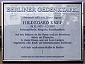
Berlin memorial plaque for Hildegard Knef , Leberstrasse 33

_Marlene_Dietrich.JPG)


_Hildegard_Knef.jpg)
Others

- Rote Insel is also called Mansteinstrasse 10 / 10a. It was during the West Berlin " houses struggle occupied the first building in Schöneberg" on January 7 1981st Today the house has a lease and sees itself as an alternative residential and house project. As it is located a few meters west of the Yorckstraße (Großgörschenstraße) S-Bahn station , it is, strictly speaking, outside the neighborhood, to whose left-wing tradition the house project still emphasizes today.
- Another place - closely related to the industrial age - is also called the Red Island : The US state of Rhode Island (originally Dutch : 'roode eiland').
- The main part of the plot of the novel Die Poggenpuhls by Theodor Fontane , completed in 1894, is located in Großgörschenstrasse.
literature
- Berlin history workshop (ed.): The red island of Berlin-Schöneberg. Fragments of a city's history. Dirk Nishen Verlag, Berlin 1987, ISBN 3-88940-131-7 . Extended new edition 2008, ISBN 978-3-925702-19-8 .
- Helmut Winz: It was in Schöneberg - from 700 years of Schöneberg history. Berlin 1964.
- Ulf Mailänder, Ulrich Zander: The little West Berlin Lexicon. Schwarzkopf & Schwarzkopf, Berlin 2003, ISBN 3-89602-518-X .
- Gisela Wenzel: The Red Island. In: Spurensicherung in Schöneberg 1933. Published by the Berliner Geschichtswerkstatt, Berlin 1983.
Web links
- St. Matthew Cemetery
- St. Elisabeth - History ( Memento from February 21, 2015 in the Internet Archive )
- Red Island Blog
- Island tour - historical walk through the Tempelhof-Schöneberg museums
Notes and individual references
- ↑ The “inner city” is usually understood to mean the urban area within the S-Bahn ring , which is called the “dog's head” due to its special curves, also in the official city planning.
- ^ Office of the party Die Linke on the Red Island
- ↑ Myspace page of the house project in Mansteinstrasse 10
- ↑ BA Tempelhof-Schöneberg: B-Plan 7-29 ( Memento from January 11, 2016 in the Internet Archive ) (PDF; 8.0 MB)
- ^ Plan from 1945 ( Memento from January 17, 2016 in the Internet Archive )
- ↑ The Schöneberg-Südkreuz urban redevelopment area ( Memento from May 4, 2014 in the Internet Archive ) (PDF; 3.7 MB) on Berlin.de . Retrieved September 11, 2013.
- ↑ News in brief - Railway . In: Berliner Verkehrsblätter . July 2017, p. 134 .
- ↑ Inselgarten project description (PDF). Retrieved August 17, 2016 .
- ↑ Thinking outside the box e. V
- ↑ Bio Island
- ↑ CoCoon. (No longer available online.) Archived from the original on August 17, 2016 ; accessed on August 17, 2016 . Info: The archive link was inserted automatically and has not yet been checked. Please check the original and archive link according to the instructions and then remove this notice.
- ↑ Carmen Böker: "Red Island" in Schöneberg: A factual romance on the red island. In: Berliner Zeitung , July 17, 2014.
- ^ The Office for Statistics Berlin-Brandenburg ( Memento from October 19, 2012 in the Internet Archive )
- ^ Urban redevelopment west. Schöneberg-Südkreuz. Right in the middle of urban redevelopment 2012. Ed .: District Office Tempelhof-Schöneberg of Berlin. Berlin 2012. Brochure, PDF
- ↑ After Theresia Ziehe: Talkin 'about the Lion and the Wolff, In: Dietrich Rünger (Ed.) Painted Jazz !: talking about Blue Note. Bad Oeynhausen, Jazzprezzo, 2014, pp. 48–56, however, according to the birth certificate, Lion was born at Wielandstraße 22.