
Saint-Martin (local authority)
| Collectivité de Saint-Martin | |||||
|
|||||
| Official language | French | ||||
| Capital | Marigot | ||||
| Head of state | President Emmanuel Macron | ||||
| Head of government | President of the Territorial Council Daniel Gibbs | ||||
| surface | 53.2 km² | ||||
| population | 35,334 (January 1, 2017) | ||||
| Population density | 664 inhabitants per km² | ||||
| currency | Euro (EUR) | ||||
| National anthem | Marseillaise | ||||
| Time zone | UTC − 4 | ||||
| License Plate | F. | ||||
| ISO 3166 | MF , MAF, 663, FR-MF | ||||
| Internet TLD | .fr , .gp and .mf | ||||
| Telephone code | +590 | ||||
  |
|||||
 |
|||||


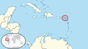
Saint-Martin is a French overseas territory in the Caribbean .
It is the only Collectivité d'outre-mer (COM) to belong to the European Union and - like the other COMs - also to the euro zone , but not to the Schengen area .
geography
The area covers an area of 53.2 km² and has 35,334 inhabitants (as of January 1, 2017).
The local authority includes the northern part of the Caribbean island of St. Martin (the southern part is occupied by the Dutch territory of Sint Maarten ) as well as some uninhabited secondary islands and rocks such as Tintamarre , Îlet Pinel, Petite Clef, Caye Verte, Caye Chateau, Rocher de l'Anse Marcel and Rocher Creole.
In addition to the main town of Marigot, there are the following settlements or districts :
- Grand case
- Rambaud
- Colombier
- Cul-de-sac
- Quartier d'Orléans.
The original four quartiers were le Marigot, le Colombier, la Grande-Case and Orléans.
The administration distinguishes six quartiers, which are numbered and for which conseils de quartier (such as local councils) have been set up in accordance with French law 2002-276 of February 27, 2002 . These quarters are not based exactly on the settlements and are described as follows:
- Quartier 1 (Quartier d'Orléans): All parts of the Quartier d'Orléans, Baie orientale.
- Quarters 2 (Grand-Case): Chevrise, Cul-de-Sac, all parts of Grand-Case, La Savane, Morne O'reilly, La Savannah housing estate.
- Quartier 3 (Friar's Bay): All parts of Rambaud, all parts of Saint-Louis, Colombier, Cripple Gate (or Colombier, Rambaud, St Louis, Friar's Bay, Pic Paradis, Morne O'Reilly).
- Quarter 4 (Agrément): Morne Valois, Agrément, Hameau du pont, Galis Bay, Grand Saint-Martin to the old hospital, Spring Concordia to the Marigot stadium.
- Quartier 5 (Marigot): city center (from the Marigot stadium) to rue de Hollande, Saint-James, Bellevue, city center (from the old hospital) across the promenade to the bridge at Sandy-Ground.
- Quartier 6 (Sandy Ground): from the bridge of Sandy-Ground, all parts of Sandy-Ground and Terres-Basses.
The names of the six administrative quarters can be found here:
The code INSEE differentiates 10 iris below the municipality level (code INSEE 978 01):
978 01 0101 	Terres Basses-Baie Nettle-Sandy Ground
978 01 0102 	Marigot Est et Nord
978 01 0103 	Marigot Centre et Sud
978 01 0104 	Saint-James-Diamant-Bellevue
978 01 0105 	Spring-Concordia
978 01 0106 	Galisbay-Agrement
978 01 0107 	C. Gate-St Louis-Rambaud-Colomb.-Pic P.
978 01 0108 	La Savane-Gd Case-Anse Marcel-Cul de Sac
978 01 0109 	Quartier d'Orleans-Gloire-Griselle
978 01 0110 	Grand Fond-Belle Plaine-Oyster Pond
The airport of the French part of the island is Saint-Martin - Grand-Case airport .
Political status
Until 2007, the French part of Saint-Martins was a municipality and, together with the neighboring island of Saint-Barthélemy, formed an arrondissement of the overseas department of Guadeloupe , the Arrondissement Saint-Martin-Saint-Barthélemy (also Arrondissement des Îles du Nord , "Arrondissement of the northern islands." "). The seat of the sub-prefecture was Marigot, but without officially having the title of capital .
After a referendum held in 2003 , Saint-Martin separated - alongside Saint-Barthélemy - from Guadeloupe on February 22, 2007 and became its own collectivité d'outre mer . However, the administration will continue to correspond to that of a French commune. However, both collectivés have fiscal autonomy , which means that French tax laws do not automatically apply there. The Lisbon Treaty provides for Saint-Martin to remain part of the European Union (and thus its westernmost point). Therefore, non-French people who come from an EU country will also be able to participate in local elections in the future. The official currency of Saint-Martin is the euro .
Web links
- Saint-Martin: Cadre carte IGN. Collection of topographic maps (French).
- Map of the census counting districts (PDF; 691 kB)
Individual evidence
- ↑ Ville de Saint-Martin, la Mairie de Saint-Martin et sa commune (97150) (Saint-Martin). Géographie - Informations géographiques générales. In: Annuaire Marie - Informations Mairie, Commune et Ville de France. Société ADVERCITY SAS, accessed on November 13, 2017 (French).
- ↑ French Statistics Institute ( www.insee.fr )
- ↑ Abel Hugo : France Pittoresque ou Description pittoresque, topographique et statistique des départements et colonies de la France . Tome troisième. Delloye, Paris 1835, Guadeloupe - Saint-Martin, S. 309 (French, full text in Google Book Search).
- ↑ Les Conseils de Quartier. Délimitation des différents quartiers. In: Site Officiel de la Collectivité de Saint Martin. Archived from the original on July 17, 2009 ; accessed on November 13, 2017 (French).
- ↑ Communiqués 1272. Grand nettoyage du quartier n ° 3. In: stmartinweek.com. Archived from the original on September 21, 2011 ; accessed on November 13, 2017 (French).
- ↑ Igor Rembotte: Saint-Martin: l'installation of the Conseils de Quartier. In: sxminfo.fr. May 1, 2013, accessed November 13, 2017 (French).
- ^ Codification des collectivités d'outre-mer (COM): Saint-Martin
- ↑ Consolidated version of the Treaty on the Functioning of the European Union. , accessed on November 13, 2017 Article 349 paragraph 1.

Member States of the United Nations
Antigua and Barbuda |
Bahamas |
Barbados |
Belize |
Costa Rica |
Dominica |
Dominican Republic |
El Salvador |
Grenada |
Guatemala |
Haiti |
Honduras |
Jamaica |
Canada |
Cuba |
Mexico |
Nicaragua |
Panama |
St. Kitts and Nevis |
St. Lucia |
St. Vincent and the Grenadines |
Trinidad and Tobago 1 |
United States
Dependent Territories
US Virgin Islands |
Anguilla |
Aruba 1 |
Bermuda |
Bonaire 1 , Saba and Sint Eustatius |
British Virgin Islands |
Curacao 1 |
Greenland |
Guadeloupe |
Cayman Islands |
Martinique |
Montserrat |
Navassa |
Puerto Rico |
San Andrés and Providencia |
Saint Barthélemy |
Saint-Martin |
Saint-Pierre and Miquelon |
Sint Maarten |
Turks and Caicos Islands
1 is on the South American continental shelf, but is politically part of North America.
Coordinates: 18 ° 6 ′ N , 63 ° 3 ′ W