
Stadtprozelten
| coat of arms | Germany map | |
|---|---|---|

|
Coordinates: 49 ° 47 ' N , 9 ° 25' E |
|
| Basic data | ||
| State : | Bavaria | |
| Administrative region : | Lower Franconia | |
| County : | Miltenberg | |
| Management Community : | Stadtprozelten | |
| Height : | 134 m above sea level NHN | |
| Area : | 10.87 km 2 | |
| Residents: | 1539 (Dec. 31, 2019) | |
| Population density : | 142 inhabitants per km 2 | |
| Postal code : | 97909 | |
| Area code : | 09392 | |
| License plate : | MIL, OBB | |
| Community key : | 09 6 76 158 | |
| LOCODE : | DE SJN | |
| City structure: | 2 districts | |
City administration address : |
Main street 132 97909 Stadtprozelten |
|
| Website : | ||
| Mayor : | Rainer Kroth ( CSU ) | |
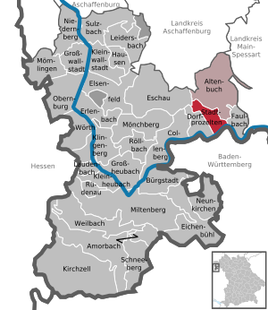
| Location of the city Stadtprozelten in the Miltenberg district | ||
  |
||


Stadtprozelten is a town in the Lower Franconian district of Miltenberg in Bavaria and the seat of the administrative association of the same name .
geography
Geographical location

Stadtprozelten is located on the southern edge of the Spessart am Main in the middle of the southern side of the so-called Mainviereck. The topographically highest point of the urban area is at 474 m above sea level. NN south of Wildensee , the lowest is in the Main at 129 m above sea level. NN .
City structure
Stadtprozelten has two districts, which correspond to the districts , for three locations:
The Neuenbuch district is 2 km from the city center ( 49 ° 48 ′ 13.8 ″ N , 9 ° 24 ′ 31.8 ″ E ).

Neighboring communities
| Eschau market |
Community Altenbuch |
|
| community Dorfprozelten |
.svg)
|
Community Faulbach |
| City of Wertheim |
Surname

etymology
The name is made up of the Middle High German word brat , which means roast or meat and the Old High German selde for house . Roast pelder therefore means roughly the same as place where travelers can dine; about a hostel . The addition city has been added to differentiate between village and length processes . The first letter of the original name is still included in the city coat of arms.
Earlier spellings
Earlier spellings of the place from various historical maps and documents:
|
|
history
Until the church is planted
Stadtprozelten was first mentioned as a city in 1287. After Swedes sacked the place in 1632, the residents had to supply the imperial troops of Captain Paur over the winter of 1634/35, which cost them over 6,000 guilders. The former Kurmainzische Amt became part of the Dalbergian Principality of Aschaffenburg (from 1810 department of the Grand Duchy of Frankfurt ) and came to Bavaria in 1814 . In the course of the administrative reforms in Bavaria, today's municipality was created with the municipal edict of 1818 .
Administrative history
In 1862 the district office of Marktheidenfeld was formed, on whose administrative area Stadtprozelten was located. In 1939, as everywhere in the German Reich, the designation district was introduced. Stadtprozelten was now one of the 47 communities in the Marktheidenfeld district . With the dissolution of the Marktheidenfeld district, Stadtprozelten came to the newly formed Miltenberg district on July 1, 1972 .
650 years of city rights were celebrated in 2005. The first documentary mention has actually not yet been clarified beyond doubt.
Incorporations
On July 1, 1977, the previously independent community of Neuenbuch was incorporated.
politics

City council
The city council of Stadtprozelten has twelve members. The mayor is also a member. After the last local elections , the following allocation of seats resulted:
| Election year | CSU | SPD | FWG | total |
| 2020 | 6th | 2 | 4th | 12 seats |
| 2014 | 7th | 3 | 2 | 12 seats |
| 2008 | 8th | 4th | n / A. | 12 seats |
| 2002 | 5 | 2 | 5 | 12 seats |
mayor
The first mayor is Rainer Kroth (CSU). He was elected in the 2020 local elections with a share of the vote of 50.65 percent. His slightly inferior competitor was Jürgen Weiskopf (FWG). His predecessor was Claudia Kappes (CSU), who was in office from May 2002 to April 2020 and no longer ran.
coat of arms
The description of the coat of arms reads: In silver a red castle with a gate tower and blue roofs, above the gate the golden letter B; on both sides of the spire the shining, face of golden sun and a face of golden crescent moon.
Culture and sights
Buildings

.JPG)
- The city is dominated by the Henneburg castle ruins on the Kühlberg.
- The hospital was probably founded by Elisabeth von Hohenlohe around 1320.
- The hospital administration building dates from the 14th century and has been used as a post office and school house since the 18th century.
- The parish church of the Assumption of Mary , built in the Gothic style, was formerly a hospital church (today's apse). The small hospital church was extended by a nave between 1616 and 1664. A 45 m high tower was also built over the old sacristy. In the wake of the expansion measures, the sacred building was raised to a parish church instead of the former Georgskirche (now a pharmacy). The church was lengthened by 8 m in the years 1930–1936, the floor was raised because of the danger of flooding the Main, the coffered ceiling of the nave gave way to a wooden barrel vaulted ceiling and the interior was redesigned. The altars with paintings and wooden sculptures date from the immediate post-war period of the Second World War.
- The town hall was built in 1520, the stair tower was added in 1621. The bay window sits on two Tuscan columns.
- The beneficiary building was probably a parsonage until around 1811.

- The pharmacy was built after 1811 on the site of the demolished George Chapel.
- Office building from around 1600; Mainz administration building, district court in the 19th century, then savings bank
- former prison from the 19th century
- Remains of the late medieval city wall
- Forsthaus, built in 1854 in the "New Munich Byzantine Style"
- The Mevlana Mosque Stadtprozelten in the Brasselburg district has been an Islamic house of prayer for mainly Turkish Muslims since 1990 .
Regular events

Shepherd dance
The Schäfflertanz is traditionally performed every seven years. The Schäffler Group, possibly the largest in Germany and the only one in white and blue, consists of well over 60 to 90 actors, i. H. Head sheepdogs, wine glass sellers, dancers, clowns, waiters and the boys who pull the cart. Since the dance is a group dance, the number of exclusively male dancers is always a multiple of eight.
This tradition dates back to the plague year of 1517, when the members of the Schäfflerzunft in Munich were the first to take to the streets again to spread the joy of life.
From around 1830, journeyman shepherds (craftsmen such as cooper, barrel makers, cooper or cooper who made wooden barrels for beer, wine, etc.) brought the dance to other places such as B. to Eggenfelden, Frontenhausen, Geiselhöring, Mainburg, Mühldorf, Murnau, Kelheim, Landshut, Partenkirchen and Wasserburg.
In 1887, the shepherd's dance was performed for the first time in Stadtprozelten. The next dates fall in 2020, 2027 etc.
Doude Moo
The origin goes back to the time when corpses were removed from houses during the plague. The corpse collectors shouted “Hejo - doude Moo - moje kommd en annern droo” (hello, dead man, tomorrow will be someone else's turn).
Nowadays the children are happy that sweets are thrown from every house on the street during this parade, if a straw doll was carried out of the village and burned beforehand. Doude Moo always takes place on a Sunday, three weeks before Easter.
The event is called "Todemo" in official circles.
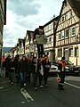
The Doude Moo is carried out.

The children scream "out, out" ...

... and then collect the candy.


traffic
Stadtprozelten has a train station on the Miltenberg West – Wertheim railway line .
sons and daughters of the town
- Georg Anton von Stahl (1805–1870), bishop of Würzburg and theologian from 1840 to 1870
- Ignaz Stahl (1839–1902), Catholic theologian
- Fritz Halberg-Krauss (1874–1951), landscape painter and important representative of the Munich School
- Wilhelm Rupprecht (1886–1963), painter and glass painter
- Gustav Richter (1912–1997), SS-Sturmbannführer and employee in the Reich Security Main Office as well as convicted war criminal
Oddities
Stadtprozelten
According to J. Heyberger, Christian Schmitt and August Wilhelm von Wachter, the Stadtprozeltener "Geißhockler" must entitle the heights can be because the poor wretches in the dangerous days of the flood piggyback their goats up to bear on the grass courts.
Neuenbuch
In the Spessart valleys, rooms were illuminated with the pine wood. The poorer population had no money for expensive petroleum . In Neuenbuch they were called "Kieknörzli". This dialect name gave rise to the nickname - Ortsnecknames .
Individual evidence
- ↑ "Data 2" sheet, Statistical Report A1200C 202041 Population of the municipalities, districts and administrative districts 1st quarter 2020 (population based on the 2011 census) ( help ).
- ↑ a b http://www.suedspessart.de/home/stadtprozelten
- ↑ http://www.bayerische-landesbibliothek-online.de/orte/ortssuche_action.html ? Anzeige=voll&modus=automat&tempus=+20111127/111528&attr=OBJ&val= 1707
- ↑ a b Wolf-Armin von Reitzenstein : Lexicon of Franconian place names. Origin and meaning . Upper Franconia, Middle Franconia, Lower Franconia. CH Beck, Munich 2009, ISBN 978-3-406-59131-0 , p. 212 ( limited preview in Google Book search).
- ↑ Georg Veh: Of incompetent teachers and "stubborn spots". In: Wertheimer Zeitung from 19./20. January 2013
- ^ Federal Statistical Office (ed.): Historical municipality directory for the Federal Republic of Germany. Name, border and key number changes in municipalities, counties and administrative districts from May 27, 1970 to December 31, 1982 . W. Kohlhammer GmbH, Stuttgart / Mainz 1983, ISBN 3-17-003263-1 , p. 751 .
- ↑ Stadtprozelten - City Council Election 2020
- ↑ Election of the first mayor 2020, Stadtprozelten, overall result , accessed on June 14, 2020
- ↑ Information according to the memorial plaque inside the church.
- ^ Werner Trost: Stampes, Worzelköpp and Staffelbrunzer Landkreis Miltenberg 2003
Web links
- City websites
- Entry on the coat of arms of Stadtprozelten in the database of the House of Bavarian History

Altenbuch | Amorbach | Bürgstadt | Collenberg | Dorfprozelten | Eichenbühl | Elsenfeld | Erlenbach am Main | Eschau | Faulbach | Großheubach | Großwallstadt | Hausen | Kirchzell | Kleinheubach | Kleinwallstadt | Klingenberg am Main | Laudenbach | Leidersbach | Miltenberg | Mömlingen | Mönchberg | Neunkirchen | Niedernberg | Obernburg am Main | Röllbach | Rüdenau | Schneeberg | Stadtprozelten | Sulzbach am Main | Weilbach | Wörth a.Main
Unregulated areas: forest forest | High maintenance