
Elsenfeld
| coat of arms | Germany map | |
|---|---|---|

|
Coordinates: 49 ° 51 ' N , 9 ° 10' E |
|
| Basic data | ||
| State : | Bavaria | |
| Administrative region : | Lower Franconia | |
| County : | Miltenberg | |
| Height : | 123 m above sea level NHN | |
| Area : | 24.39 km 2 | |
| Residents: | 9138 (Dec. 31, 2019) | |
| Population density : | 375 inhabitants per km 2 | |
| Postal code : | 63820 | |
| Primaries : | 06022, 09374 | |
| License plate : | MIL, OBB | |
| Community key : | 09 6 76 121 | |
| LOCODE : | DE ELF | |
| Market structure: | 7 districts | |
Market administration address : |
Marienstrasse 29 63820 Elsenfeld, Germany |
|
| Website : | ||
| Mayor : | Kai Hohmann (CSU) | |
| Location of the Elsenfeld market in the Miltenberg district | ||
  |
||

Elsenfeld is a market in the Miltenberg district in Lower Franconia .
geography
Geographical location

Elsenfeld is located in the Bavarian Lower Main region on the right side of the Main across from Obernburg am Main on the western edge of the Spessart, roughly between the northern Aschaffenburg, 16 km away, and the southern district town of Miltenberg, 20 km away . The market is cut through by the river Elsava , which flows into the Main in Elsenfeld . The topographically highest point of the municipality is 407 m above sea level. NN (location) on the summit of the Eichelsberg north of Eichelsbach, the lowest is in the Main at 116.5 m above sea level. NN (location) .
Community structure
There are seven officially named districts (the type of settlement in brackets):
- Eichelsbach ( Kirchdorf )
- Elsenfeld
- Himmelthal ( hamlet )
- Kreuzmühle (factory)
- Neuhof ( wasteland )
- Rück (Kirchdorf)
- Schippach ( parish village )
Neighboring communities
| Großwallstadt | Kleinwallstadt | Hausen , Heimbuchenthal |
| Obernburg am Main |
.svg)
|
Eschau |
| Erlenbach am Main , forest forest area free of municipalities | Mönchberg |
The community is part of the Rhein-Main area . Neighboring communities are in the north of Markt Kleinwallstadt (with the district Hofstetten), in the east the Spessart-Markt Eschau (with the districts Hobbach , Sommerau and Wildensee ), in the south the town of Erlenbach am Main (with the districts Mechenhard and Streit) and in the west, beyond the Main, the already mentioned town of Obernburg am Main (with the district Eisenbach). There is also a common border in the area of the Himmelthal forest with the Mönchberg market .
Surname
etymology

The original name Elsaphe comes from the Elsava river on which the place is located. Later the basic words -feld and temporarily -hoven were added.
Earlier spellings
Earlier spellings of the place from various historical maps and documents:
|
|
history
Until the church is planted
The area around Elsenfeld was settled more than 5000 years ago. Band ceramic (Bronze Age) grave finds near Eichelsbach and Rück-Schippach attest to this. However, there was probably no continuous settlement from pre-Franconian times. A relatively dense settlement can be seen for the period around 1600–700 BC. Evidenced by barrows near Eichelsbach. The actual historical period did not begin until the 6th century.
The oldest settlements in today's municipality are Eichelsbach and Schippach. Elsenfeld was first mentioned in a document in 1122. The first documentary mention of Schippach was in 1233, when Count and Countess Rieneck added land around Schippach to the property of the Himmelthal Monastery . Rück first appeared around 1270 in the so-called Mainzer Heberolle . In the middle of the 13th century, all places appeared together in the “Koppelfutter-Directory”. Eichelsbach (Egilespach, also Aigils- or Egilspach) was "serf".
The sovereign of the area was the Archbishop and Elector of Mainz . The resident landlords thus became fiefs of Mainz.
Up until the Reichsdeputationshauptschluss 1803, the development of the place was strongly linked to the castle, town, court, official and cellar ownership of Klingenberg. In 1803 the area became part of the Principality of Aschaffenburg in the Kurerzkanzlerisches Staat, from 1806 the primate state of Carl von Dalberg.
In 1810 Elsenfeld fell to the Grand Duchy of Frankfurt and in 1814 became the property of the Kingdom of Bavaria . Eichelsbach and the remaining Himmelthaler “possessions” were finally released from serfdom and labor.
In the course of the administrative reforms in Bavaria, today's municipality was created with the municipal edict of 1818 .
Administrative history
On July 30, 1828 Elsenfeld has been prepared by the Regional Court Klingenberg separated and the district court Obernburg allocated, which is up to the county reform remained 1,972th
In 1862 the district office of Obernburg was formed, on whose administrative area Elsenfeld was located. As everywhere in the German Reich , the term district was introduced in 1939. Elsenfeld was now one of the 35 communities in the district of Obernburg am Main . With the dissolution of the district of Obernburg, Elsenfeld came to the newly formed district of Miltenberg on July 1, 1972 .
Incorporations
On July 1, 1971, the previously independent communities of Eichelsbach, Rück and Schippach voluntarily joined the Elsenfeld market.
Population development
| year | 1961 | 1970 | 1987 | 1991 | 1995 | 2000 | 2005 | 2010 | 2015 |
| Residents | 5141 | 6908 | 7370 | 7931 | 8482 | 8744 | 8870 | 8822 | 9015 |
religion
The inhabitants of Elsenfeld and its districts are predominantly Catholic. The Catholic parishes Christkönig and St. Josef in Elsenfeld with the St. Barbara branch in Eichelsbach and St. Pius in Schippach (Rück-Schippach) have merged to form the parish community Christ Salvator . The parish church Christkönig in Elsenfeld with the parsonage and the parish office is the seat of the pastor. In the summer months, especially on weekdays or for weddings, the old parish church of St. Gertraud , built in 1767 in the baroque style, is used. Until the Christ the King's Church was built in 1957, it was the parish church of the Catholic community. Catholic services are held regularly in the Dominic senior home . There is also the Catholic parish church of St. Pius in Schippach (Rück-Schippach) , the Baroque-style churches of St. Antonius (Schippach) and St. Johannes (Rück), the former Jesuit church of St. Sebastian in Himmelthal monastery and in Eichelsbach the village church of St. Barbara , as well as several smaller chapels.
The parish hall of the Evangelical Lutheran parish and the Catholic parish and youth home “St. Gertraud ”offer spaces for youth work and other social offers.
There has been a mosque since 1987, which provides rooms for youth, women, community service and other social activities. There has been a new mosque since 2010.

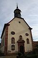
St. Gertraud Elsenfeld

Old parish church of St. Gertraud

Local history museum with church in the background
Christ the King Church
Johanneskirche in Rück


politics
Market council

The market council consists of 20 honorary members. The following diagram shows the composition since the municipal council election on March 15, 2020 .
mayor
On March 15, 2020, Kai Hohmann (CSU) was elected First Mayor with 51.3% of the vote. His predecessor was Matthias Luxem (Independent Civic Association) from May 2008 to April 2020.
Second mayor is Berthold Oberle (UBV) and third mayor Anna Becker (SPD / Greens).
European elections
In the 2019 European elections, the CSU won 37.06% of the vote, the Greens 17.33% and the SPD 11.27%. The turnout was 56.89%.
Community finances
In 2017, the municipal tax revenue was 8,527,000 euros, of which 2,775,000 euros were business tax revenue.
coat of arms
The coat of arms of the Elsenfeld market is split into red and silver. On the left side ( heraldic right ) there is a silver diagonal wave bar and a silver, six-spoke wheel . On the right side (heraldic left) there is a green elsen tree on a green background.
The wave bars represent the geographic location of the municipality on the Elsava river. At the same time, it stands for the place name, which is derived from the river name. The Elsenbaum stands for the place name designation "Elsen-". The silver wheel and the colors silver and red stand for the former affiliation to the Kurstaat Mainz .
Elsenfeld has had this coat of arms since 1954.
Town twinning
On May 28, 2005 Elsenfeld signed a town partnership with the city of Condé-sur-Noireau in the French department of Calvados .
Economy and Infrastructure

economy
According to official statistics, there were 663 employees in the manufacturing sector in 2014 and 605 in the trade, transport and hospitality sectors at the place of work. In other economic sectors 639 people were employed at the place of work subject to social security contributions. There were a total of 3,395 employees subject to social security contributions at the place of residence. There were five in the manufacturing sector and eight in the construction sector. In 2010 there were also 16 farms with an agricultural area totaling 561 hectares, of which 418 hectares were arable land and 132 hectares were permanent green space.
In the district of Rück there is a wine-growing area for Franconian wine with the location names z. B. Rücker Schalk or Jesuitenberg .
Part of the Elsenfeld area is an industrial site called Industrie Center Obernburg (ICO), which is also known to the population under the name of Glanzstoff (after the former operator). Traditionally, different types of man-made fibers are produced there. In addition, numerous small companies from various industries can be found at the location. Although the industrial center bears the name Obernburg and this is also the place of the postal address, it is only located in the districts of the municipalities of Erlenbach am Main and Elsenfeld.
traffic

train
Elsenfeld has a station on the Aschaffenburg – Miltenberg railway line , which is run as the Obernburg-Elsenfeld station, but it is actually in the Elsenfeld district. From there there are regular regional connections to Aschaffenburg and in the direction of Miltenberg . The Obernburg-Elsenfeld-Heimbuchenthal railway was closed for passenger traffic as early as 1968. Freight traffic to Eschau ( Baywa warehouse) was maintained until 1978 . Most of the railway line has been converted into a cycle path .
Street
Elsenfeld is connected to Obernburg with two main bridges. The Main Bridge Obernburg / Elsenfeld ( state road 2308 ) for vehicles, bicycles and pedestrians connects the town with the junction Obernburg am Main of the federal road 469 . In addition, there is the former old Main Bridge Elsenfeld-Obernburg, which was raised on the old bridge piers and converted into a bicycle and pedestrian walkway . A spacious bypass road was also built in order to relieve the congestion on state road 2309 through the inner town .
Education and culture
Educational institutions
Elsenfeld offers 377 kindergarten places in five day-care centers (2015).
- schools
- Mozart Elementary School
- Georg Keimel Middle School (with M train and open all-day school), around 310 students
- State secondary school Elsenfeld, around 1000 students
- Julius-Echter-Gymnasium (linguistic high school, economics and social science high school with a social science profile), around 800 students
- Special schools
- Elsava school for educational assistance with a day care center for therapeutic education, Himmelthal Abbey
- Richard-Galmbacher-Schule (support center with support focus on intellectual development)
- Janusz Korczak School (School for Learning Promotion)
- Foundation for the Blind Institute Elsenfeld branch
Local museum
The local history museum, opened in 1980, is located in Elsenfeld's oldest half-timbered house. It shows over 6000 exhibits from handicraft and agriculture. Everyday objects and pictures provide insights into the history of the community. The museum is run by the Elsenfeld Local History and Museum Association and is only open on special occasions.
Civic Center

The community center, built in 1992, regularly offers space for various cultural events by associations, for celebrations, lectures, conferences and concerts. The forecourt is used at village festivals and at the Christmas market, the so-called "Kläuschenmarkt".
Library
The community operates a community library with around 22,700 media.
Architectural monuments
Leisure and sports facilities
Leisure pool
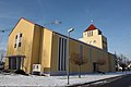
In 2001 the indoor pool was renewed and reopened as the Elsavamar leisure pool . The pool includes a 25-meter swimming pool with a non-swimmer area and a water and rock play area for toddlers. There is a cafeteria in the foyer and bathing area. A winter garden with access to the leisure area and the sunbathing area invites you to relax. There are hydrojetting and solarium options. In November 2007 a sauna was opened, the so-called "Roman sauna".
Elsavapark leisure center
On April 30, 2000, the largest multifunctional beach sports facility in Northern Bavaria with six beach volleyball fields was opened in the former outdoor pool area . In the former diving pool, a skate facility with halfpipe , a 450 square meter wet biotope , an integrated festival area with boules , a badminton and street ball court , table tennis tables, large chess fields, a music pavilion and, in the former paddling pool, a water and adventure playground for children up to set up for ten years.
Sports facilities
There are a variety of sports facilities: Lawn sports and soccer field Spessartstadion , forest sports field, sports field in the back, tennis courts and hall, bowling alley, Elsavaturnhalle with gymnasium. Furthermore, the so-called Sparkassenarena (formerly Untermainhalle ), which is the regular venue for games of the handball Bundesliga team TV Großwallstadt and the second division team TUSPO Obernburg and in which the German national handball team has already played two international matches in 1971 against Luxembourg and 1977 against Iceland.
tourism

Himmelthal Monastery
The Himmelthal Summer Concerts have been held in the Himmelthal Monastery since 1984 due to the excellent room acoustics in the monastery church . The monastery also houses the wine tasting room of Markt Elsenfeld and Weinbauverein Rück e. V., which is open every second Sunday of the month. The Elsavaschule, a special educational school with a day care center for therapeutic education, is also located on the monastery grounds.
Hiking trails

Since 1990 Elsenfeld has been on the 55 kilometer long Franconian red wine hiking trail that leads from Großwallstadt to Bürgstadt. On the former Obernburg-Elsenfeld-Heimbuchenthal railway line , a cycling and hiking trail runs through the district, following the Elsava, to Heimbuchenthal .
Personalities
- Daniel Haas (born August 1, 1983), soccer goalkeeper
- Maria Happel (born October 16, 1962), actress and director
- Ludwig Hofmann (born July 19, 1912 - September 14, 1979), record pilot, test pilot and aviation pioneer
- Anja Kohl (born July 27, 1970), journalist and presenter
- Joachim Spatz (born January 5, 1964), chairman of the FDP Lower Franconia and former member of the state parliament
- Barbara Weigand (born December 10, 1845 - March 20, 1943), seer and mystic
- Heidemarie Wright (born February 20, 1951), SPD member of the German Bundestag
Oddities
The right side of the Main is known as a particularly sandy soil. It is loose, nutrient-poor and water-permeable soil. Why they are called the Else fields Erlenbacher and Röllfelder residents with nickname - Ortsnecknamen "Sand hands". The residents of Kahl am Main , as well as the residents of Mainaschaff in the district of Aschaffenburg, are also called "sand bunnies".
literature
- Felix Mader : The art monuments of Bavaria. Lower Franconia XXIII. District Office Obernburg. Verlag R. Oldenbourg, Munich 1925 (Unchanged reprint. Ibid 1981, ISBN 3-486-50477-0 ).
- Eva Marie Schlicht: The market town of Elsenfeld with the districts of Rück, Schippach and Eichelsbach , Verlagdruckerei Schmidt Neustadt ad Aisch, published by Markt Elsenfeld 1990
Web links
Individual evidence
- ↑ "Data 2" sheet, Statistical Report A1200C 202041 Population of the municipalities, districts and administrative districts 1st quarter 2020 (population based on the 2011 census) ( help ).
- ↑ Municipal Council. Elsenfeld community, accessed on June 16, 2020 .
- ↑ Markt Elsenfeld: The market in numbers
- ↑ Marktgemeinde Elsenfeld in the local database of the Bayerische Landesbibliothek Online . Bayerische Staatsbibliothek, accessed on June 13, 2020 ..
- ↑ a b Wolf-Armin von Reitzenstein : Lexicon of Franconian place names. Origin and meaning . Upper Franconia, Middle Franconia, Lower Franconia. CH Beck, Munich 2009, ISBN 978-3-406-59131-0 , p. 63–64 ( limited preview in Google Book search).
- ^ Wilhelm Volkert (ed.): Handbook of Bavarian offices, communities and courts 1799–1980 . CH Beck, Munich 1983, ISBN 3-406-09669-7 , p. 543 .
- ↑ European elections: Markt Elsenfeld
- ^ Entry on Elsenfeld's coat of arms in the database of the House of Bavarian History
- ↑ Werner Trost Stampes, Worzelköpp and Staffelbrunzer Lkr.Miltenberg 2003

Eichelsbach | Elsenfeld | Back with Himmelthal , Kreuzmühle and Neuhof | Schippach

Altenbuch | Amorbach | Bürgstadt | Collenberg | Dorfprozelten | Eichenbühl | Elsenfeld | Erlenbach am Main | Eschau | Faulbach | Großheubach | Großwallstadt | Hausen | Kirchzell | Kleinheubach | Kleinwallstadt | Klingenberg am Main | Laudenbach | Leidersbach | Miltenberg | Mömlingen | Mönchberg | Neunkirchen | Niedernberg | Obernburg am Main | Röllbach | Rüdenau | Schneeberg | Stadtprozelten | Sulzbach am Main | Weilbach | Wörth a.Main
Unregulated areas: forest forest | High maintenance