
Via Julia
Via Julia is the modern name for the Roman military road between Günzburg ( Guntia ) via Augsburg ( Augusta Vindelicorum ) to Salzburg ( Iuvavum ).

With Via Julia a street name from the research of the 19th century was taken up, the work of her in Julian imperial family saw. As far as we know today, apart from the Via Claudia Augusta, no Roman road north of the Alps has a name.
history
The road was strategically very important for the Roman Empire . Up until the third century AD, its construction and route made it possible to move troops quickly to secure the empire. As part of the connection between Lutetia (now Paris ) and Constantinople , now Istanbul , it was the main connection between the provinces of Raetia and Noricum and was also recorded in the Tabula Peutingeriana .
The route from Augsburg (AVGVSTA VINELICVM) to Salzburg (IVVAVVM) is almost completely covered by archaeological finds.
History: Augsburg ( AVGVSTA VINDELICVM ) Neukissing ( Kissing ), Mering , Merching , Heinrichshofen , Jesenwang, Schoengeising (AD Ambrae) Gilching , Gauting ( BRATANANIUM ) Buchhain (Baierbrunn) Gleißental at Deisenhofen (Oberhaching) , Klein Help village (ISINISCA) , Pfaffenhofen am Inn ( Schechen ) ( PONS AENI ), Leonhadspfunzen ( AD ENUM ), Söchtenau , Dorfbach ( Bad Endorf ), Straß ( Eggstätt ), Seebruck ( BEDAIUM ), Wolkersdorf ( Traunstein ), Lauter (Surberg) , Teisendorf, Straß ( Ainring ), Bruch-Römerstraße (Ainring), Liefering , Salzburg ( IVVAVVM )
The importance of the road is proven by the 15 milestones of the emperor Septimius Severus , which herald a road construction program of their own. No other Roman road in southern Germany is known to have as many pillars as the Via Julia .
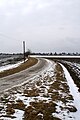
From Günzburg via Augsburg and Rosenheim to Salzburg, a bicycle path has been signposted along a historical route. The Via Julia is well preserved as a cycle path between Hofolding and Aying in the Hofolding Forest . The long straight route and the original material pits at the edge can be seen there.
Milestones received

near Kraimoos ( Grabenstätt )
in Egerdach
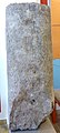
in the Roman museum Bedaium


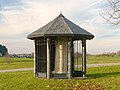
Present appearance
At Buchendorf

At Chieming


Further research
A research contribution considers a route over the Würmmühle (Dachau) (Ambrae), Pretzen near Erding (Bratananium), Isen (Isinisca) and a place near Wasserburg am Inn (Pons Aeni) to be likely.
However, this route cannot be substantiated with archaeological finds.
literature
- Cycling in the footsteps of the Roman road Via Julia: Günzburg - Augsburg - Salzburg . Augsburg 2007, ISBN 978-3-00-021104-1 .
Individual evidence
- ↑ https://www.kbl.badw-muenchen.de/zblg-online/rezension_1326.html
- ↑ Hans Bauer: The Roman highways between Iller and Salzach according to the Itinerarium Antonini and the Tabula Peutingeriana. New research results on route guidance. Munich 2007, u. a. P. 103ff. And Artur Adam: Roman travel routes and station names in south-eastern Germany, in: Contributions to name research. Neue Episode 11 (1976), pp. 1-59.
- ↑ Route sketches by Hans Bauer, accessed on October 18, 2016