
Traunstein
| coat of arms | Germany map | |
|---|---|---|

|
Coordinates: 47 ° 52 ' N , 12 ° 39' E |
|
| Basic data | ||
| State : | Bavaria | |
| Administrative region : | Upper Bavaria | |
| County : | Traunstein | |
| Height : | 591 m above sea level NHN | |
| Area : | 48.55 km 2 | |
| Residents: | 20,599 (Dec. 31, 2019) | |
| Population density : | 424 inhabitants per km 2 | |
| Postal code : | 83278 | |
| Area code : | 0861 | |
| License plate : | TS, LF | |
| Community key : | 09 1 89 155 | |
| City structure: | 63 districts | |
City administration address : |
Stadtplatz 39 83278 Traunstein |
|
| Website : | ||
| Lord Mayor : | Christian Hümmer ( CSU ) | |
| Location of the city of Traunstein in the Traunstein district | ||
  |
||


Traunstein is a city in the administrative region of Upper Bavaria with over 20,000 inhabitants. It is a large district town and regional center on the Traun . The city is the capital of Chiemgau and the district town of the district of the same name .
As an administrative town with the Traunstein District Court, Traunstein is responsible for the districts of Traunstein , Rosenheim , Berchtesgadener Land , Altötting and Mühldorf . With 25 schools and over 10,600 pupils, it also forms an important educational location in southeast Bavaria.
geography
Geographical location
Traunstein, the capital of the Chiemgau , is about ten kilometers east of the Chiemsee and 15 km north of the Chiemgau Alps . The city is traversed in its eastern parts by the river Traun . In the southeast is the district of Hochberg , which is also Traunstein's local mountain . The parish village of Haslach is located south of Traunstein below the Hochberg an der Traun . In the west lies the village of Wolkersdorf . Both were incorporated in 1978. In the north, separated by the city forest and the Kammer practice area, lies the parish village of Kammer , which was incorporated in 1972, with the town of Rettenbach.
Community structure
Traunstein has 63 districts in 6 districts :
| District | Population * | Area in km² | Population density in inhabitants per km² | Districts |
|---|---|---|---|---|
| Au | 877 | 0.39 | 2249 | no |
| Haslach | 3,267 | 5.83 | 560 |
Axdorf , Büchling , Einham , Irlach , Haslach, Neuling , Oberhaid , Seiboldsdorf , Tinnerting , Wegscheid |
| Hochberg | 306 | 10.24 | 30th | Abstreit , Bach , meadows , book Hochfelln , Daxerau , Eppenstatt , trench , Hochberg, Hochöd , courtyards , Holzleiten , Hütt , Kirchleiten , Mitterbichl , upper PEP , Öd in the pitch cutting , Paulöd , Preising , Rutzöd , Schinagl , Schwaig , Schwober , sub ÖLN |
| chamber | 1,465 | 15.64 | 94 | Alterfing , Gerating , Haunstätt , Kaltenbach , Kammer, Kronacker , Langmoos , Leiderting , Lüfteneck , Marberloh , Neuhausen , Reichsberg , Rettenbach , Roitwalchen , Siegelberg |
| Traunstein | 11,468 | 9.78 | 1173 | Baumgarten , Empfing , Gamm , Mayerhofen , Sparz , Traunstein |
| Wolkersdorf | 2,488 | 6.70 | 371 | Geißing , Guntramshügl , Höpperding , Kotzing , Riederting , Schmidham , Traunstorf , Unterhaid , Wolkersdorf |

* As of December 31, 2015
Incorporations
On January 1, 1914, the previously independent municipality of Au , the location of the Traunsteiner Saline , was incorporated. As part of the regional reform in Bavaria , the previous municipality of Kammer and parts of the dissolved municipality of Hochberg (northern part) were added on July 1, 1972 , Wolkersdorf and most of the dissolved municipality of Haslach followed on May 1, 1978.
history
Until the 19th century
Church property registers mention possessions ad Trun as early as 790 , and medieval fortifications ( castle stables ) can also be proven in the vicinity from the 10th century ( Burg Traunstein , Burgstall Traunstein , Burgstall Hochberg and Burgstall Lenzisburg ). Trauwenstain itself is first mentioned in 1245 in a document from the Baumburg monastery . The name means castle on the Traun, and with some probability the seat of the Lords de Truna was here, surrounded by a small settlement. It was only the Wittelsbachers who built it up according to plan, fortified it and thus controlled the crossing of the Traun River on the important salt road from Reichenhall to Munich on the border with the Salzburg archbishopric .
_1969,_MiNr_602.jpg)
In 1120 the noble 'von Truna', ministerials of the Counts of Kraiburg - Ortenburg , settled in today's urban area, probably because of the strategically favorable location: They built the castle on the edge of the town plateau near the trade route, which is largely from River is surrounded. The gentlemen "de Truna" are mentioned in sources from 1242 for the last time.
Traunstein was first mentioned in a document in 1245. In the first contract of Erharting (1254) the Archbishop of Salzburg waived the acquisition of the counties and courts in Chiemgau. The Chiemgau with Traunstein fell to the Wittelsbach family, who saw the town as an important strategic and economic hub right on the border with the Archbishopric of Salzburg. Traunstein was ideally located on a hill directly on the Traun and thus on the trade route from Reichenhall to Munich. From here, the entire movement of goods across the Traun could be controlled. The Wittelsbachers therefore had Traunstein fortified and expanded, and they gave it trade and customs privileges.
Documents about the elevation of the place to the city have been lost - according to historical sources by fire. The city was founded around the middle of the 13th century, because in 1255 Truna is listed as Traunstein among those cities that were part of the dukes Ludwig the Strict and Heinrich XIII. The division of Bavaria made to Duke Heinrich in 1255 . After losing the original document for the founding of the city, Duke Friedrich of Bavaria renewed Traunstein's city privileges in a letter of freedom in 1375 .
The new role as "Guardian of the Salt Road" brought Traunstein great prosperity early on. The salt from Bad Reichenhall was stored and transshipped here in order to be transported on to Munich or Wasserburg. The traders were forbidden to bypass transshipment points like Traunstein, and so the city earned with every delivery over the Traun. The streets and alleys were paved as early as 1493. From 1431 Traunstein had a "Leprosenhaus" ( Leprosorium ), the location of which is unclear. In 1526 the Lindlbrunnen with Rossschwemme was built as the end point of the city's water supply.

In 1587 Duke Wilhelm finally nationalized salt production, which suddenly made Traunstein unprofitable for the rich salt broadcasters. They then left the city, which until then was economically heavily dependent on the salt trade. Due to the good transport connections and the reputation as a craftsmen and market center, Traunstein survived this upheaval economically but largely unscathed. In 1613, another very rich brine spring was discovered in Reichenhall . The saltworks there was already working at its capacity limit. Although the city was already supplied with considerable amounts of firewood from the Pinzgau in Salzburg via the Trift systems , this was not enough to sift the additional brine on site. Duke Maximilian I therefore decided in 1616 to route the brine to Traunstein via a pipe system. Sufficient firewood could be brought to Traunstein with the water of the Traun, and the forests were owned by the duke. For the brine pipeline to Traunstein , a distance of 31 km and a height difference of 340 m had to be overcome. Pumps operated with water power in seven wells carried the brine upwards, which then, using the natural gradient, flowed to the next well. About 9000 drawbars were used as pipes . The line was built by the court architect Hanns Reiffenstuel and his son Simon . In Traunstein, meanwhile, a new district was built in the Au - consisting of a saltworks , brewing facilities, hardening houses and workers' apartments - for the newly won branch of the economy. After three years of construction, the saline was put into operation in 1619.
Although Traunstein was largely spared the atrocities of the Thirty Years' War (1618–1648), it was not affected by the plague that followed, from which almost a tenth of the population died between 1631 and 1635. On July 25 and 26, 1704, Austrian troops occupied Traunstein in the course of the War of the Spanish Succession . A devastating city fire changed the medieval cityscape considerably (see below), which, however, could be rebuilt despite many years of Austrian occupation.
In 1782, Elector Karl Theodor commissioned the renovation of the salt works in Traunstein. Among other things, this resulted in the construction of the cross-shaped brewhouse in 1787. The annual salt production and the efficiency of the production increased rapidly. The completion of the new saltworks ensured the continuation of salt production in Traunstein for another 100 years.
In 1808 Traunstein lost almost all rights as a result of the first Bavarian constitution. In spite of this, the city remained the administrative and trading center of the Chiemgau, which was particularly important for Bavaria's third largest grain market. On the night of April 25-26, 1851, another major fire destroyed almost the entire city (see below).
20th century


The urban image and history of the Bavarian-Catholic administrative center was largely shaped in the years between 1890 and 1914, so that the city today has a significant number of Wilhelminian-style and Art Nouveau buildings. In 1912, the last Traunstein saltworks in the Au was closed .
On January 1, 1914, the previously independent community of Au was incorporated into Traunstein; during the First World War , the saltworks served both as a camp for more than 1,000 civilian and war prisoners and as a hospital ; At the beginning of 1919 Adolf Hitler was assigned to guard the prisoners for a few weeks. After the First World War, hyperinflation occurred due to the global economic crisis in 1923 and emergency money with amounts in the billions also circulated in Traunstein.

During the Second World War , the Traunstein station area was the target of American bombing four times: on November 11, 1944, January 21, 1945, April 18, 1945 and finally on April 25, 1945. The heavy bombing in April 1945 destroyed the station area by more than 100 people died. A little later, on May 2, 1945, Jewish concentration camp prisoners crossed Traunstein on a death march . 61 of them were shot the next day near Surberg (a memorial there commemorates them). The city was surrendered without a fight on May 3, 1945.
With the local elections in January 1946, democratization began, building on structures prior to 1933. Displaced people had to be cared for and integrated. From 1948 to 1972 (as between 1876 and 1935) Traunstein was an independent city. In the course of the municipal reform , Traunstein was incorporated into the district of Traunstein on July 1, 1972 and received the status of a major district town .
The cityscape changed in 1998 with the reconstruction of the Jacklturm, which fell victim to the fire in 1851.
21st century
In December 2012, Traunstein celebrates the completion of the B304 northern bypass, which Peter Ramsauer described as a "building of the century". The 4.5 km long project took over 40 years and cost € 77 million. The construction of a 385 meter long viaduct over the Traun and the 725 meter long Ettendorfer Tunnel was necessary for the bypass. It now serves to relieve the inner city, which was passed through by approx. 26,000 vehicles every day.
On September 1, 2013, the city of Traunstein was classified as a regional center by the regional planning authorities . As a result, Traunstein is now responsible for the surrounding medium-sized and sub-centers as an authority and education center. The area of influence includes the districts of Traunstein, Berchtesgadener Land, Altötting, Mühldorf and parts of Rosenheim.
In 2017, the city exceeded the limit of 20,000 inhabitants for the first time and thus changed from a small to a medium-sized town.
City fires
In its 750-year history, the city of Traunstein was hit at least twice by city fires: on August 13, 1704, when Hungarian Pandours set the city on fire in the course of the War of the Spanish Succession , and in 1851. For unknown reasons, the first big one is said to be in 1371 City fire took place, to which a district including the church fell victim. There are no contemporary reports on this, but Duke Friedrich von Bayern renewed the city privileges in 1375 because the original document was burned - a fire must have taken place shortly before. It has been suggested that this first fire could have started in a brickworks near the district . Recent archaeological excavations in the area of the former fortress (castle) seem to confirm the oral tradition. In 1586 ten houses burned down in the lower Zwerchzeile (Hofgasse). In the following year, a fire code was issued for the city area for the first time. This was still valid in the 19th century.

After the fire of 1704, the city was largely restored. The noble seat of Neugereut, built by the Schaumburgers, with the castle of the same name on the north side of the city, which also went up in flames, was not rebuilt.
On the night of April 25th to 26th, 1851, Traunstein was the victim of a fire that almost completely destroyed the early modern townscape. As after 1704, it was possible this time to rebuild Traunstein within a few years. A total of 90 houses and 30 utility buildings in the downtown area fell victim to the flames, including the town hall, the regional court, the main salt office and the rent office, the church and all gates and towers (with the exception of the upper one). Only today's Heimathaus, “Zieglerwirtschaft und Brothausturm”, Schaumburgerstrasse and five houses on the north side of the town square opposite the church were spared. The fire broke out in a barn next to the parsonage under construction on Maxplatz and, aided by the strong wind, made its way at breakneck speed over the roofs covered with wooden shingles. All efforts of the domestic and foreign fire fighting and spraying teams were in vain, because: "Once the fire has exceeded a certain limit, no human violence is able to stop it." Many citizens lost all their belongings.
The cause of the fire was initially assumed to be an act of revenge by angry Haslachers, caused by the recent relocation of the parish seat from their village to Traunstein. It was later rumored that a servant's negligence caused the fire. Both assumptions are unproven.
Around 700 citizens were homeless, but the city was helped immediately. King Maximilian visited Traunstein on April 27 and transferred several thousand guilders from his cabinet. Aid committees were set up in many cities to collect donations in cash and in kind. Thanks to the rapid disbursement of the fire insurance funds, the residents were soon able to start rebuilding. The medieval floor plan of the town square was largely retained, but the houses were given historical facades, in keeping with the taste of the time. With the construction of a new town hall between 1855 and 1857 - on the foundations of the Stallechner fire ruins - the reconstruction was largely completed after only six years.
Today's cityscape
The architecture of the city of Traunstein was strongly influenced by city fires and wars and thus brought a mixture of different epochs with it. There are still a few buildings from the late Middle Ages to be found around the town square. Most of the buildings in the upper old town had to be rebuilt after city fires and therefore mostly date from the 19th century. The lower old town was built around the saltworks in the 17th century. Although the brewhouse itself is no longer preserved, numerous workers' houses are still in good condition today. Another important epoch is the period between the 19th and 20th centuries. Here Traunstein grew rapidly and almost tripled its population. The city achieved this growth through the targeted recruitment of wealthy pensioners to make Traunstein a spa town. The result is now numerous suburban villas of the most varied architectural styles, which still characterize the Traunstein cityscape today.

One of the few remaining buildings from the late Middle Ages. The community center in the town square.

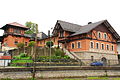
Typical architectural style of the lower Traunstein old town from the 17th century. The saltworks houses .

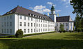
Typical architectural style of the upper Traunstein old town from the 19th century. The town hall.
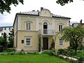
Late classicist villa from 1874.

Historicized villa from 1892.

New baroque villa from 1894.

Baroque villa from 1902.

Classical Art Nouveau villa with its own observatory from 1915.


Demographics
| year | population | Remarks |
|---|---|---|
| 1808 | 2,500 | |
| 1818 | 2,333 | in 243 houses, counted in the dean's office in Haslach in mid-1818 |
| 1824 | 1,550 | 435 families, 216 houses, counted in the administrative year 1823/24 of the Isarkkreis |
| 1840 | 3,931 | |
| 1900 | 6,845 | including 327 Evangelicals, 6.501 Catholics |
| 1905 | 7,447 | mostly Catholic residents, including 376 Evangelicals and 33 Jews |
| 1910 | 7,686 | thereof 466 Evangelicals, 7,163 Catholics |
| 1925 | 9,028 | including 649 Evangelicals, 8,310 Catholics, eight other Christians and nine Jews |
| 1933 | 9,882 | 608 Protestants, 9,186 Catholics, one other Christian and seven Jews |
| 1939 | 10,962 | including 927 Protestants, 9,798 Catholics, twelve other Christians and one Jew |
| 1950 | 14,611 | |
| 1960 | 14,900 | 3,100 of them displaced |
| 1988 | 17,145 | |
| 2010 | 18,707 | |
| 2018 | 20,520 | since 1988 an increase of 19.7% |
The population development in Traunstein has been shaped by a wide variety of growth rates over the years. While the population more than quadrupled from 1840 to 1950, a stagnation of around 18,000 inhabitants that lasted over 50 years began. Since 2014, Traunstein has experienced another surge of growth, which in 2017 raised the city for the first time above the 20,000 inhabitant limit and made it a medium-sized town. Between 1988 and 2018 the city grew from 17,145 to 20,520 by 3,375 inhabitants or 19.7%. The forecasts also assume continued strong growth in the coming years. The average cold rent in Traunstein rose to around € 10 / m² in 2018, making it the highest in the entire region.
In 2018, Traunstein recorded a proportion of foreigners of 12.61% and an unemployment rate of 2.7%. In 2011, 61.3% of the population were Roman Catholic and 13.7% Protestant.

politics
City council
The local elections on March 2, 2008 , March 16, 2014 and March 15, 2020 resulted in the following allocation of seats:
| Party / list | CSU | SPD | GREEN | Independent voters |
Traunsteiner List |
Traunstein initiative |
THE LEFT | total |
|---|---|---|---|---|---|---|---|---|
| Seats 2008 | 8th | 5 | 2 | 7th | 2 | 24 | ||
| Seats 2014 | 8th | 5 | 4th | 5 | 2 | 24 | ||
| Seats 2020 | 10 | 4th | 7th | 4th | 2 | 2 | 1 | 30th |
mayor
The mayor Fritz Stahl (SPD), who has been in office since 1990, did not run for the local elections in 2008 due to his age. The newly elected Lord Mayor of Traunstein, Wilfried Arsan (Independent Voters - UW), was found dead on April 7, 2008. At the suggestion of the city, the state municipal supervisory authority had therefore appointed the previous second mayor, Hans Zillner, as the representative for official business that cannot be postponed for the period from May 1, 2008 until the constituent city council meeting on May 8. Zillner was re-elected as 2nd mayor at the meeting of the city council; he managed the official business until the election of a new mayor by the population on July 13, 2008. Here again the candidate of the independent voters, Manfred Kösterke, was elected as the new mayor with 54.66% of the votes.
A total of five applicants ran in the 2014 local elections; In the runoff election, the SPD applicant, Christian Kegel, won with 50.76% and replaced Manfred Kösterke (49.24%).
In the 2020 local elections, incumbent Christian Kegel lost to Christian Hümmer (CSU) in the runoff election on March 29, 2020, who received 60.05% of the valid votes.
City arms
|
|
_(cropped).jpg)
|
|
|
City arms of Traunstein
|
Old town coat of arms of Traunstein
|
The current city coat of arms has existed in its present form for centuries ( three hills and two lilies ). In the Middle Ages, however, the coat of arms looked different: there were two halberds above three gates. From this it can be concluded that the branch was originally planned and built primarily as a fortified facility and from a military perspective. Remnants of the former city fortifications still bear witness to this today.

In addition to the coat of arms, the Lindl is also a symbol of the city of Traunstein. The "Marbelstein man on the fountain", built in 1526, still stands today as part of the Lindl fountain on the town square. It represents a knight in Maximilian armor and once stood for the freedom of the city of Traunstein.
Town twinning
Traunstein has four twin cities :
- The French gap (since 1976)
- The German Wesseling am Rhein (since 1984)
- The Italian Pinerolo in Piedmont (since 1986)
- The English Haywards Heath in Sussex (since 1993)
There are frequent student exchanges and mutual visits between Traunstein and its partner cities.
Culture and sights

Cultural institutions
- the local history museum (Am Stadtplatz 2/3)
- the Städtische Galerie (Ludwigstrasse 12; drawings, book illustrations, woodcuts, etc.)
- the municipal cultural center in the city park
- the saltworks park
Regular cultural events include:
- the symphonic concerts in Traunstein
- the Traunstein Summer Concerts
- the summer of music between Inn and Salzach
- the Chiemgau music spring
- the Traunsteiner Lindl singing and making music
- the Traunstein Music Culture Nights (once in spring and once in autumn)
Regular concerts and theater performances also take place in Nuts - the culture factory . The trompe brass ensemble Die Bayerischen Jungwölfe is one of the cultural bearers
From 1996 to 2013 there was the Traunstein Cat Museum, a private collection of cat figurines.
Attractions
- Remains of the city fortifications (Brothausturm, Löwentor, parts of the city wall)
- Former residential and brewhouses of the salt works
- the saltworks chapel St. Rupertus in the Au district (important early baroque frescoes)
- the "Traunstein", a large, half-in-the-river fall block from the at least Ice Age Nagelfluh
- the Lindl fountain with the Wappner (on the town square)
- the Jacklturm (rebuilt in 1998 after it fell victim to the fire in 1851)
- the parish church of St. Oswald (baroque paintings, old frescoes) the evangelical church of the Resurrection (neo-Gothic)
- the viaduct from 1860, 105 meters long and 25 meters high.
- the Hochberg , one of the most beautiful viewpoints in the Chiemgau
- the chapel oak with a BHU of 6.55 m (2015).
See also: List of architectural monuments in Traunstein
Soil monuments
See: List of ground monuments in Traunstein

The Traunstein landmark, the Jacklturm . Originally built in the 16th century.

City parish church of St. Oswald from the 12th century on Traunstein town square.

The bread house tower from 1541 , gate tower of the former upper gate.

Karl-Theodor-Platz with the saltworks chapel St. Rupertus .

One of the former workers' houses of the salt works from 1618 on Karl-Theodor-Platz.

Viaduct for rail traffic from 1860.
Former summer cellar and hall of the Höllbrauerei , laid out around 1800.
Studienseminar St. Michael from 1928. A boarding school of the Archdiocese of Munich Freising.

Former central castle from 1770. Today it serves as a rectory.


religion

Due to its geographical location in south-east Bavaria, Traunstein is traditionally shaped by Roman Catholics and therefore has primarily churches of this religious community. The history of today's Traunstein church building goes back to the 12th century and has always been an important part of the cityscape. The Catholic town church of Traunstein is made up of a total of 4 town parish churches:
- The parish church of St. Oswald on Traunsteiner Stadtplatz is the primary church of the former Pope Benedict XVI and a landmark of Traunstein.
- The Annunciation in the district of Haslach from the 14th century is the second of four parish churches in Traunstein.
- The parish church Heilig Kreuz from 1954 is the youngest of all churches in Traunstein and served to support displaced persons after the war.
- The parish church of St. John the Baptist in the Kammer district was formerly part of the Otting parish in Rupertiwinkel . It dates back to 1452 and has largely preserved its original structure to this day.

In addition, there are other Catholic churches in Traunstein that are not part of the city church but are used on different occasions:
- The saline chapel (Aukirche) is used regularly for church services, weddings and devotions in the summer months.
- In St. Georg and Katharina in the city park, in addition to Roman Catholic. Church services, devotions and Vespers are regularly held by the Greek Catholic community. During the summer months, the portal of the former cemetery church (until 1908) is open every Saturday afternoon.
- The "Ettendorfer Kircherl" stands on a small hill northeast of the city above the Trauntal; it is a branch church of the parish of St. Oswald Traunstein in the area of the community of Surberg. Ettendorf was a well-known place of pilgrimage for many centuries. Traditionally, the church is the destination of the “Traunsteiner Georgiritt” on Easter Monday (see below). In the summer months there are also church services from time to time, as a wedding church it is in great demand; the association organ friends St. Oswald Traunstein e. V. organizes the concert series "Music in the Church" there.
- On the hill east of the city and the former saltworks community of Au rises next to the institute of the English Miss Sparz - the school has meanwhile been handed over to ecclesiastical sponsorship by the order - the church "St. Josef “Sparz , the so-called Sparzer Kircherl .
- The monastery church of the former Capuchin monastery in Traunstein , which has been owned by the city for several decades, serves as the "Kunstraum Klosterkirche" for concerts and art exhibitions under the sponsorship of the ARTS cultural promotion association. The monastery church is currently being renovated by the city of Traunstein for around € 10.8 million, expected to be in 2019, and then used as an event building.
In addition to the Catholic churches, there is also an Evangelical Lutheran congregation in Traunstein . This consists of the Protestant churches in Chieming and Waging and the neo-Gothic Church of the Resurrection in Traunstein . A Free Evangelical Congregation has also existed since 2012 .
In addition, other religious communities have a seat in Traunstein, such as the Jehovah's Witnesses and the New Apostolic Church .
Georgiritt

The Georgiritt in Traunstein, with over 500 horses one of the largest horse pilgrimages in Bavaria, has been taking place every year on Easter Monday since 1892. Historical documents go back to the year 1762. An important destination is the Ettendorfer Kircherl on a hill in the northeast of the city. The Traunsteiner Georgiritt, which honors Saint George , has been a UNESCO cultural heritage since 2016 .
sports clubs
The Traunstein section of the German Alpine Club , founded on December 9, 1869, is the largest sports club in Traunstein with almost 7,100 members . It owns two huts (the Neue Traunsteiner Hütte on the Reiteralpe and the Traunsteiner Skihütte on the Winklmoos-Alm ) and operates a DAV climbing center.
The SB Chiemgau Traunstein , located in the district of Empfing, is one of the largest and, with its football and handball department, one of the most successful sports clubs in the region. It emerged from the two traditional clubs 1. FC Traunstein and ESV Traunstein.
Economy and Infrastructure


According to the 2017 district ranking by the business magazine “ Focus-Money ”, the Traunstein district was ranked 10th among all districts, municipal associations and independent cities in Germany. The district was able to improve by 3 places compared to the previous year and is therefore the front runner in the region. With 14,000 jobs, Traunstein is the most important business location in the district.
retail trade
Traunstein traditionally has a reputation as a shopping city. In addition to numerous boutiques and traditional smaller shops in the city center, there is the Haslach industrial area, where mainly supraregional retail chains have settled. The Kaserne industrial park is located on the site of the demolished Prinz-Eugen- Kaserne .
In 2017, retail sales were € 305.64 million, and retail-relevant purchasing power was € 139.91 million. Purchasing power was € 7,448 per inhabitant and the purchasing power index was 107.6%.
Nationally important companies in Traunstein are:
- the Kliniken Südostbayern AG with 3300 employees, 2000 of them in Traunstein.
- Pohlig GmbH in the field of orthopedic technology with around 300 employees at its headquarters in Traunstein.
- JN Kreiller AG as a wholesaler and manufacturer of building materials with 300 employees.
- the forwarding company Eberl GmbH & Co KG with 270 employees.
- the Kotter GmbH bakery with 23 branches and 250 employees.
- Haumann + Fuchs Ingenieure AG with 125 employees.
- Osenstätter Kraftfahrzeuge GmbH with 3 car dealerships and 170 employees.
- the Gesellschaft für Wolfram Industrie GmbH, with 120 employees as a manufacturer of high-performance materials made of tungsten and molybdenum.
- Leimer KG as the German market leader for breadcrumbs with over 90 employees.
- the Chiemgau health center with 66 employees.
- Murschhauser GmbH as a wholesaler for paints and varnishes with 60 employees.
.jpg)
Breweries
The brewing industry is culturally deeply anchored in the history of Traunstein and is still an important economic component today. The city gives itself the unofficial name "Bierstadt Traunstein". The reason for this is the high density of breweries that has shaped Traunstein for centuries. The Hofbräuhaus Traunstein from 1612 is the largest and most famous brewery in Traunstein with an output of around 100,000 hl of beer and lemonade. Other operations are the oldest Schnitzlbaumer brewery from 1575 and the smallest brewery, the Wochinger Brewery from 1587 with an annual output of 8,000 hl. The Kiesel and Weißbräu companies have ceased production.
tourism
Traunstein is located in a recreational region around the Chiemsee and is therefore also shaped by tourism. In 2017, the city with its 278 guest beds recorded a total of 34,515 overnight stays and 24,656 guest arrivals.
media
The Traunsteiner local newspaper is called Traunsteiner Tagblatt (formerly: Traunsteiner Wochenblatt). In addition, there was Radio Chiemgau in Traunstein , which broadcasted from there to the whole of Chiemgau; on January 1, 2009 it was merged with Untersberg live to form the radio station Bayernwelle SüdOst , based in Freilassing , which today covers the districts of Berchtesgadener Land and Traunstein, including adjacent areas .
Educational institutions
- Kindergartens: Municipal Kindergarten; St. Oswald Kindergarten (Catholic); Holy Cross Kindergarten (Catholic); Kindergarten St. Josef (in the children's home); Parish kindergarten Haslach; Forest kindergarten
- Elementary and secondary schools: Franz-von-Kohlbrenner-Mittelschule; Ludwig-Thoma primary school; Haslach primary school
- Special educational support center in the areas of learning, language and social-emotional development
- Realschulen:
- Maria Ward Girls Real School Sparz (Catholic, sponsored by: Archdiocese of Munich and Freising, former sponsor: Englische Fräulein)
- Reiffenstuel-Realschule;
- Private business school Dr. Kalscheuer
- High schools: Annette-Kolb-Gymnasium, Chiemgau-Gymnasium
- State technical college and vocational college
- Commercial, industrial and domestic vocational schools
- Adult education center with an extensive program
- Montessori school
- Municipal library
- Municipal music school
- Chamber of Crafts for Munich and Upper Bavaria - Traunstein Training Center
- Catholic study seminar St. Michael - boarding school of the Archdiocese of Munich and Freising
police
The city of Traunstein used to have a city police force , which was nationalized in 1971. In 1937 a motorized gendarmerie was stationed in Traunstein . In 1938 it was given a barracks on Eugen-Rosner-Strasse. The area is used today by the Bavarian police .
Judiciary
Traunstein is the seat of a local court and a regional court .
In addition to the criminal and civil courts, the Traunstein District Court has a registry court , a probate court , a family court , an enforcement court and a guardianship court .
The district court of Traunstein is responsible for the districts of Traunstein, Rosenheim , Berchtesgadener Land , Altötting and Mühldorf am Inn as well as the district-free city of Rosenheim. The district courts in Altötting, Laufen, Mühldorf am Inn, Rosenheim and Traunstein are subordinate to him.
Traunstein is also the seat of the Traunstein correctional facility with around 140 inmates and 38 prison officials (as of 2015). The Traunstein prison has existed since 1858 and has been continuously expanded and modernized over the course of its history. The institution is responsible for detainees on remand and criminal detainees up to 12 months from the district court districts of Traunstein, Rosenheim, Mühldorf, Altötting and Laufen.
Telecommunication tower Traunstein
The telecommunications tower Traunstein ( 47 ° 51 '32 " N , 12 ° 36' 44" O ) is in the neighborhood Einham a 35 meter high steel concrete tower of Deutsche Telekom AG in prefabricated concrete structure, in addition to the radio and the mobile phone also for the dissemination of the following radio programs in VHF range is used:
| program | frequency | Transmission power ( ERP ) | RDS PS |
|---|---|---|---|
| Deutschlandradio Kultur | 88.3 MHz | 0.1 kW | DKULTURE |
| Bayernwelle Southeast | 99.4 MHz | 0.3 kW | BAYWELLE |
| Antenna Bavaria | 103.7 MHz | 5 kW | ANTENNA |
traffic
Traunstein is a traffic junction in eastern Upper Bavaria.

South of Traunstein there is a connection to the federal motorway 8 ( E 52 ) from Munich to Salzburg . In Traunstein the federal road 306 branches off from the federal road 304 ( Dachau - Freilassing ) to Inzell . Other supraregional connections lead to the Chiemsee and Waginger See , among others .
Since December 7, 2012, the so-called northeast bypass has been inaugurated with the symbolic traffic opening of the "Ettendorfer Tunnel", whereby the B304 now passes Traunstein and no longer runs through the city center. The new, around 4.5 kilometers long northeast bypass connects the intersection of the two federal highways B304 / B306 directly with the north of the city.
The Traunstein train station is on the Rosenheim – Salzburg railway line and is the stop for InterCity and EuroCity trains. A connection between Traunstein and the Salzburg S-Bahn is being considered. The branch lines to Waging , Mühldorf am Inn (the Traun-Alz Railway ) and Ruhpolding also begin here . Other railway stations in the city are the Traunstein-Klinikum stop on the Traun-Alz-Bahn and the Seiboldsdorf stop on the Traunstein – Ruhpolding line .
International airports are located in Munich (Franz Josef Strauss Airport, MUC, approx. 120 km away) or Salzburg (Salzburg Airport WA Mozart, SZG, approx. 35 km away). The Schönberg airfield of Fliegergruppe Traunstein eV is located 21 km north of Traunstein and 2 km northeast of Kienberg. It is classified as a special airfield and is mainly used for air sports with powered aircraft, gliders and ultralight aircraft.
health

Traunstein is the seat of the municipal clinic association Kliniken Südostbayern and its central clinic in Traunstein , which is the city's largest employer with over 2000 employees and 500 beds.
Former garrison

Traunstein was also affected by the armament of the Wehrmacht from 1934 onwards . The area of the newly built Badenweiler barracks had a size of 15.789 hectares and offered space for 2000 soldiers. In October 1935, parts of the Mountain Infantry Regiment 100 were billeted. In 1936 they were from III. Battalion of the 61st Infantry Regiment relieved. After the Second World War , the Bundeswehr used the Prinz Eugen barracks (renamed in 1964) from 1956 to 1997 . Staff buildings, two farm buildings and four accommodation buildings were available for up to 1200 soldiers. Until the area was abandoned, the 8th Mountain Air Defense Regiment was stationed in the Prinz-Eugen-Kaserne , which was equipped with M16 half-track vehicles , M42 anti-aircraft tanks and later Gepard . In 1997, the Federal Ministry of Defense decided to close the barracks and move the soldiers to Pocking . The city of Traunstein had tried in vain to avert this decision, as there was a good relationship between the city and the soldiers. Nevertheless, on May 14, 1997, the last soldiers had to leave the Prinz Eugen barracks. The buildings were preserved until the decision to use them in the future in 2002, after which they were then demolished for the Kaserne business park .
Personalities
Honorary citizen
Other personalities

Josef Ratzinger , former Pope Benedict XVI.

Alfons Schuhbeck , one of the most successful German star chefs.

Tobias Angerer , former German cross-country skier and Olympic champion.


_01.jpg)
literature
- Anton Kasenbacher: Traunstein. Chronicle of a city in words and pictures , Grabenstätt 1986
- Götz von Dobeneck : The Jacklturm , in: Festschrift "10 years Förderverein Alt-Traunstein 1983-1993" , Traunstein 1993, pp 41-61
- Friedbert Mühldorfer: Resistance and persecution in Traunstein 1933–1945 , Ingolstadt 1992
- Rainhard Riepertinger: The Saline Traunstein , in: Salz Macht Geschichte (essays) , Augsburg 1995, pp. 103-110
- Heinrich Letzing: The Gasthof "Sternbräu" and the Hofbräuhaus Traunstein: two breweries of different traditions in one hand , in: Yearbook of the Historical Association for the Chiemgau zu Traunstein 9 (1997) , pp. 57-90
- Gerd Evers: Traunstein 1918–1945, A contribution to the history of the city and the district of Traunstein , Grabenstätt 1991
- Gerd Evers: Liberation, occupation, renewal, district and town of Traunstein 1945–1949 , Ising 1996
- Gerd Evers: I did nothing but my duty , Ising 2008
- Johann Josef Wagner: Topographical history of the city of Traunstein . In: Upper Bavarian Archive for Fatherland History , Volume 19, Munich 1858–1860, pp. 167–246 ( online ).
Web links
- www.traunstein.de
- Entry on the coat of arms of Traunstein in the database of the House of Bavarian History
- Traunstein: Official statistics of the LfStat
- Franz Haselbeck: Traunsteiner Stadtgeschichte , Traunstein, approx. 2017 (PDF, 27 pages, accessed on March 29, 2020).
Individual evidence
- ↑ "Data 2" sheet, Statistical Report A1200C 202041 Population of the municipalities, districts and administrative districts 1st quarter 2020 (population based on the 2011 census) ( help ).
- ↑ a b Bavarian State Office for Statistics: Statistics communal 2017. Bavarian State Office for Statistics, January 31, 2018, accessed on October 12, 2018 .
- ↑ Traunstein, GKSt in the local database of the Bavarian State Library Online . Bayerische Staatsbibliothek, accessed on June 25, 2018.
- ^ Wilhelm Volkert (ed.): Handbook of Bavarian offices, communities and courts 1799–1980 . CH Beck, Munich 1983, ISBN 3-406-09669-7 , p. 602 .
- ^ Federal Statistical Office (ed.): Historical municipality directory for the Federal Republic of Germany. Name, border and key number changes in municipalities, counties and administrative districts from May 27, 1970 to December 31, 1982 . W. Kohlhammer, Stuttgart / Mainz 1983, ISBN 3-17-003263-1 , p. 593 .
- ↑ a b c Freyheitsbrief - From Duke Friederich in Baiern etc. of the Baierische Gränz = city of Traunstein, given in 1375 . In: Materials for the History of the Fatherland , Volume 1, Munich 1782, pp. 57–92.
- ^ Johann Joseph Wagner: Topographische Geschichte der Stadt Traunstein , Munich 1859, pp. 12-13.
- ↑ see data from the Society for Leprosy in Bavaria, accessed on October 15, 2016 ( Memento of the original from February 6, 2015 in the Internet Archive ) Info: The archive link was inserted automatically and has not yet been checked. Please check the original and archive link according to the instructions and then remove this notice.
- ↑ Adolf Hitler: Aufriß über mein Person, 1. Continuation In: Der Spiegel , April 9, 1973.
- ↑ Free travel on the bypass. OVB Online, December 8, 2012, accessed October 20, 2018 .
- ↑ Johann Joseph Wagner: History of the Royal Bavarian Regional Court Traunstein and its secular and ecclesiastical components , Munich 1868, p. 10.
- ^ Carl von Lama: Guide through Traunstein, Salinenstadt and Curort in Upper Bavaria , Augsburg 1877, p. 9.
- ^ Johann Joseph Wagner: Topographical History of the City of Traunstein , Munich 1859, p. 61.
- ↑ Johann Joseph Wagner: History of the Royal Bavarian District Court Traunstein and its secular and ecclesiastical components , Volume 2, Munich 1866, p. 46.
- ^ Johann Joseph Wagner: Chronicle of the noble seat and castle Greut and Neugereut zu Traunstein , Munich 1854.
- ↑ Anton Miller, one of the spiritual fathers of the Traunstein Volunteer Fire Brigade, which was founded in 1859 as a reaction to the city fire
- ^ A b Franz Haselbeck: City history of Traunstein. City of Traunstein, accessed on October 14, 2018 .
- ↑ Georg Heinrich Kexser :: elementary geography of the Kingdom of Bavaria on the use of schools , Munich 1810, p 91 ( online ).
- ↑ Martin von Deutinger : Tabular description of the Diocese of Freysing according to the order of the Decanate , Munich 1820, p. 519 ( online ),
- ↑ Deutinger, loc. cit., Vorerinnerung , p. VII
- ↑ Adolph von Schaden : Alphabetical directory of all the cities, markets, villages, hamlets, wastelands, etc. located in the Isar district (as an appendix to the topographical = statistical handbook for the Isar district of the Kingdom of Baiern, E copy ), Munich 1825, p. 497 ( online )
- ↑ Adolph von Schaden : Topographisch = Statistical Handbook for the Isar Circle of the Kingdom of Bavaria , printed and published at the expense of the Königl. Government of the Isarkkreis, Munich 1825 ( online ).
- ↑ a b c d e f g M. Rademacher: German administrative history from the unification of the empire in 1871 to reunification in 1990. City and district of Traunstein (online material for the dissertation, Osnabrück 2006)
- ^ Meyer's Large Conversational Lexicon . 6th edition, Volume 19, Leipzig / Vienna 1909, pp. 680–681 ( zeno.org ).
- ↑ Rent index Traunstein, Oberbay 2018 - rental prices for apartments. Retrieved October 12, 2018 .
- ↑ Traunstein. In: statistik.arbeitsagentur.de. Retrieved October 12, 2018 .
- ^ The 2008 election results. (No longer available online.) Archived from the original on April 24, 2014 ; accessed in April 2014 . Info: The archive link was inserted automatically and has not yet been checked. Please check the original and archive link according to the instructions and then remove this notice. and the city of Traunstein: Vorl_Ergbnis_Stadtratswahl_2014.pdf ( page no longer available , search in web archives ) Info: The link was automatically marked as defective. Please check the link according to the instructions and then remove this notice. , accessed July 10, 2014
- ↑ Regional. In: The world . April 8, 2008, accessed June 25, 2018 .
- ^ Re-election of the mayor in 2008. (No longer available online.) Archived from the original on March 29, 2009 ; accessed on June 25, 2018 . Info: The archive link was inserted automatically and has not yet been checked. Please check the original and archive link according to the instructions and then remove this notice.
- ^ Quirky museums in Bayer: Katzenmuseum, Traunstein . In: Süddeutsche Zeitung of February 13, 2012
- ↑ Bavarian Geological State Office
- ^ Entry in the directory of monumental oaks . Retrieved January 10, 2017
- ↑ Traunstein town church: Home. Retrieved October 16, 2018 .
- ↑ Church of the Resurrection Traunstein | Parish of Traunstein. Retrieved October 16, 2018 .
- ^ Photographs from 2002 from the cycle Heimat by Andreas Bohnenstengel
- ^ Section Traunstein of the German Alpine Club
- ↑ FOCUS-MONEY district ranking 2017. Focus Money, January 10, 2017, accessed on October 12, 2018 .
- ↑ a b Traunstein in numbers. Large district town of Traunstein, accessed on October 12, 2018 .
- ↑ Chiemgau-Blätter / Traunsteiner Tagblatt (number 37, September 12, 2015) (accessed on February 1, 2020)
- ↑ Brief information on the Traunstein prison. (PDF) In: justiz.bayern.de. Bavarian State Ministry of Justice, January 1, 2015, accessed on October 16, 2018 .
- ↑ rfo.de ("Regionalfernsehen Oberbayern") - "Symbolic route approval of the Traunsteiner local bypass" ( memento of the original from September 24, 2015 in the Internet Archive ) Info: The archive link was inserted automatically and not yet checked. Please check the original and archive link according to the instructions and then remove this notice. (accessed on December 9, 2012, 1:08 pm)
- ↑ br.de (“Bayerischer Rundfunk”) - “Ettendorfer Tunnel - Opening of the Traunstein Bypass” ( memento of December 10, 2012 in the Internet Archive ) (accessed on December 9, 2012 - 1:11 pm).
- ↑ chiemgau24.de - "Traunstein bypass in the Ettendorfer tunnel officially inaugurated" (accessed on December 9, 2012, 1:13 pm)
- ↑ That was the barracks in Traunstein - Chiemgau Blätter 2017 - Traunsteiner Tagblatt . ( traunsteiner-tagblatt.de [accessed on October 16, 2018]).
- ↑ That was the barracks in Traunstein - Chiemgau Blätter 2018 - Traunsteiner Tagblatt . ( traunsteiner-tagblatt.de [accessed on October 16, 2018]).

Altenmarkt an der Alz | Mountains | Chieming | Engelsberg | Fridolfing | Grabenstätt | Grassau | Inzell | Kienberg | Kirchanschöring | Marquartstein | Nussdorf | Obing | Palling | Petting | Pittenhart | Reit im Winkl | Ruhpolding | Schleching | Schnaitsee | Seeon-Seebruck | Siegsdorf | Staudach-Egerndach | Surberg | Tacherting | Taching at the lake | Tittmoning | Traunreut | Traunstein | Trostberg | Overseas | Unterwössen | Vachendorf | Waging am See | Wonneberg
Unregulated areas: Chiemsee | Waginger See