Great Sampford: Difference between revisions
No edit summary Tags: Reverted Mobile edit Mobile web edit |
Yoshi24517 (talk | contribs) m Reverted edits by 2A02:C7C:746C:C300:3DCE:BEB8:F803:EEBD (talk): not providing a reliable source (WP:CITE, WP:RS) (HG) (3.4.12) |
||
| (10 intermediate revisions by 8 users not shown) | |||
| Line 1: | Line 1: | ||
{{Use dmy dates|date=April 2022}} |
|||
[[File:Great Sampford Church - geograph.org.uk - 879262.jpg|right|thumb|Great Sampford Church]] |
[[File:Great Sampford Church - geograph.org.uk - 879262.jpg|right|thumb|Great Sampford Church]] |
||
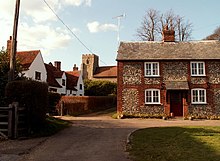
[[File:Great Sampford, Essex - geograph.org.uk - 148788.jpg|right|thumb|St Michael's Church from the Thaxted end of the village.]] |
[[File:Great Sampford, Essex - geograph.org.uk - 148788.jpg|right|thumb|St Michael's Church from the Thaxted end of the village.]] |
||
'''Great Sampford''' is a village and [[civil parish]] on the junction of the [[B1053 road|B1053]] and [[B1051 road]]s in the north-west of the [[English county]] of [[Essex]]. The population of the civil parish at the [[United Kingdom Census 2011|2011 Census]] was 586.<ref>{{cite web|url=http://www.neighbourhood.statistics.gov.uk/dissemination/LeadKeyFigures.do?a=7&b=11123957&c=CB10+2NX&d=16&e=62&g=6426478&i=1001x1003x1032x1004&m=0&r=0&s=1443436588578&enc=1|title=Civil Parish population 2011|accessdate=28 September 2015}}</ref> The village includes a primary school, two places of worship and one public house. It is located three miles to the north-east of the town of [[Thaxted]] and eight miles to the south-east of [[Saffron Walden]]. |
'''Great Sampford''' is a village and [[civil parish]] on the junction of the [[B1053 road|B1053]] and [[B1051 road]]s in the [[Uttlesford]] district, in the north-west of the [[English county]] of [[Essex]]. The population of the civil parish at the [[United Kingdom Census 2011|2011 Census]] was 586.<ref>{{cite web|url=http://www.neighbourhood.statistics.gov.uk/dissemination/LeadKeyFigures.do?a=7&b=11123957&c=CB10+2NX&d=16&e=62&g=6426478&i=1001x1003x1032x1004&m=0&r=0&s=1443436588578&enc=1|title=Civil Parish population 2011|accessdate=28 September 2015}}</ref> The village includes a primary school, two places of worship and one public house. It is located three miles to the north-east of the town of [[Thaxted]] and eight miles to the south-east of [[Saffron Walden]]. |
||
It used to have a [[RAF]] airfield called [[RAF Great Sampford]]. The [[River Pant]] runs through the south of the village. |
It used to have a [[RAF]] airfield called [[RAF Great Sampford]]. The [[River Pant]] runs through the south of the village. |
||
| Line 10: | Line 11: | ||
The village contains two churches - the [[Baptist Church]], which also owns a small hall adjacent to the property, used by the community for the pre-school; and also a [[Church of England]] parish church, St Michael's. |
The village contains two churches - the [[Baptist Church]], which also owns a small hall adjacent to the property, used by the community for the pre-school; and also a [[Church of England]] parish church, St Michael's. |
||
Also in the village is a green |
Also in the village is a green and cricket club. Next to the green is a playground which includes a skatepark, donated by the [[National Lottery (United Kingdom)|National Lottery]] Fund, a [[zip wire]] funded by an Uttlesford District Council Community Grant, a small football pitch and a tennis court. |
||
==Governance== |
==Governance== |
||
Latest revision as of 22:45, 5 November 2023


Great Sampford is a village and civil parish on the junction of the B1053 and B1051 roads in the Uttlesford district, in the north-west of the English county of Essex. The population of the civil parish at the 2011 Census was 586.[1] The village includes a primary school, two places of worship and one public house. It is located three miles to the north-east of the town of Thaxted and eight miles to the south-east of Saffron Walden.
It used to have a RAF airfield called RAF Great Sampford. The River Pant runs through the south of the village.
It is connected to Hempstead by Howe Lane.
The village contains two churches - the Baptist Church, which also owns a small hall adjacent to the property, used by the community for the pre-school; and also a Church of England parish church, St Michael's.
Also in the village is a green and cricket club. Next to the green is a playground which includes a skatepark, donated by the National Lottery Fund, a zip wire funded by an Uttlesford District Council Community Grant, a small football pitch and a tennis court.
Governance[edit]
Great Sampford is part of the electoral ward called The Sampfords. The population of this ward at the 2011 Census was 1,900.[2]
See also[edit]
References[edit]
- ^ "Civil Parish population 2011". Retrieved 28 September 2015.
- ^ "The Sampfords ward population 2011". Retrieved 28 September 2015.
External links[edit]
51°59′N 0°24′E / 51.983°N 0.400°E
