Rideau Canal: Difference between revisions
m rm periods from end of captions |
→External links: rm link accessible via another one listed here, rm linkspam |
||
| Line 60: | Line 60: | ||
*[http://www.rideaufriends.com Friends of the Rideau] |
*[http://www.rideaufriends.com Friends of the Rideau] |
||
*[http://www.remuseum.org.uk/rem_his_bio.htm Royal Engineers Museum] - Biography of Colonel By |
*[http://www.remuseum.org.uk/rem_his_bio.htm Royal Engineers Museum] - Biography of Colonel By |
||
*[http://www.rideau-info.com/canal/history/locks/malaria.html Malaria on the Rideau] |
|||
*[http://www.rideauheritageroute.ca Rideau Heritage Route - Tourism] |
*[http://www.rideauheritageroute.ca Rideau Heritage Route - Tourism] |
||
*[http://www.canadascapital.gc.ca/bins/ncc_web_content_page.asp?cid=16297-16299-10080&lang=1 Rideau Canal Skateway] |
*[http://www.canadascapital.gc.ca/bins/ncc_web_content_page.asp?cid=16297-16299-10080&lang=1 Rideau Canal Skateway] |
||
*[http://www.dowslake.com/Index.htm Dows Lake Pavillion] |
|||
*[http://www.canadascapital.gc.ca/skateway/index_e.asp Skating Conditions] (available once canal opens)] |
*[http://www.canadascapital.gc.ca/skateway/index_e.asp Skating Conditions] (available once canal opens)] |
||
* {{wikitravel}} |
* {{wikitravel}} |
||
Revision as of 14:47, 6 May 2007

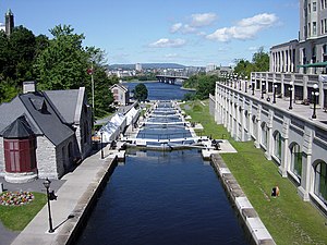
The Rideau Canal, also known as the Rideau Waterway, connects the city of Ottawa, Ontario, Canada on the Ottawa River to the city of Kingston, Ontario on Lake Ontario. The Rideau Canal was opened in 1832 and is still in use today. The canal system uses sections of major rivers, including the Rideau and the Cataraqui, as well as some lakes. It is the oldest continuously operated canal system in North America.
History

At the time it was proposed, shortly after the War of 1812, there remained a persistent threat of attack from the United States on Britain's colony of Upper Canada. To impede and deter any future American invasions, the British built various forts (eg. Citadel Hill, La Citadelle, and Fort Henry) and canals (eg.Grenville Canal, Chute-à-Blondeau Canal, Carillon Canal, and the Rideau Canal) to defend their territory.
The canal's initial purpose was military - to provide a secure supply and communications route between Montreal and Kingston, Ontario. Westward from Montreal, travel would proceed along the Ottawa River to Bytown (now Ottawa), then southwest via the canal to Kingston and out into Lake Ontario (and vice versa for eastward travel from Kingston to Montreal). The intent being to bypass the stretch of the St. Lawrence River bordering New York State which would have left British supply ships vulnerable to attack or a blockade of the St. Lawrence.
No further military engagements have taken place between Canada and the United States since the war of 1812, and consequently the Rideau Canal was never used for its intended purpose.
The construction of the canal was supervised by Lieutenant-Colonel John By of the Royal Engineers. Private contractors such as future sugar refining entrepreneur John Redpath, Thomas McKay, Nichol Taylor Hugh Baird and others were responsible for much of the construction and the majority of the actual work was done by thousands of Irish and French-Canadian labourers.

While the exact number of deaths will likely never be known, as many as a thousand of these workers may have died from malaria, other diseases and accidents such as explosions during blasting. To make matters worse, unemployment and a major cholera epidemic spread from Quebec City to Upper Canada after its completion causing further deaths. Despite this, most workers survived and many settled on area farms or entered the timber trade . Some of those who died remain unidentified as they had no known relatives in Upper Canada and were buried in unmarked graves.
Memorials to the fallen labourers (more directly toward the Irish majority) have been erected along the canal route, most recently the Celtic Cross memorials in Kingston and Lowertown Ottawa (near the Locks.)[1]
The canal was completed in 1832. The final cost of its construction was £822,000. This was more than had been expected and By was recalled to London and questioned by a parliamentary committee before being cleared of any wrongdoing.
The Waterway
The 202 kilometres (125 miles) of the Rideau Canal incorporate sections of the Rideau River and the Cataraqui River, as well as several lakes including the Lower, Upper and Big Rideau lakes. About 19 kilometres (12 miles) of the route is man made.

Today, only pleasure craft make use of the Rideau Canal. Boat tours of the canal are offered in the city of Ottawa and recreational boaters can make use of it to travel between Ottawa and Kingston with ease. Most of the locks are still hand-operated. There are a total of 47 locks at 24 stations along the Canal.
In normal operations the canal can handle boats up to 27.4m (90ft) in length, 7.9m (26ft) in width, and 6.7m (22ft) in height. In special circumstances a boat up to 33.5m (110ft) in length by 9.1m (30ft) in width can be handled.
Communities along the waterway include:
- Ottawa, Ontario
- Smiths Falls, Ontario
- Merrickville, Ontario
- Westport, Ontario
- Battersea, Ontario
- Kingston, Ontario
The Skateway
In winter, a section of the Rideau Canal passing through central Ottawa becomes officially the world's largest skating rink.[2] The cleared area is 7.8 kilometres (4.8 miles) long and has the equivalent surface area of 90 Olympic hockey rinks. It runs from the locks at Carleton University to the locks between the Parliament Buildings and the Chateau Laurier. It serves as a popular tourist attraction and recreational area and is also the focus of the Winterlude festival in Ottawa. Beaver Tails, a fried dough pastry, are sold along with other snacks and beverages, in kiosks on the skateway.
See also
- Trent-Severn Waterway Central Ontario Canal System
- Welland Canal Southern Ontario Canal System
- Saint Lawrence Seaway Ontario - Quebec waterway system
- Canal lock
References
External links
- Locks - Your guide to good times on the Rideau River and Canal
- Rideau Canal Waterway
- Rideau Canal's 175th Anniversary (2007)
- Friends of the Rideau
- Royal Engineers Museum - Biography of Colonel By
- Rideau Heritage Route - Tourism
- Rideau Canal Skateway
- Skating Conditions (available once canal opens)]
- Template:Wikitravel
