
Takakkaw Falls: Difference between revisions
→External links: +cat |
No edit summary |
||
| Line 2: | Line 2: | ||
'''Takakkaw Falls''' ({{IPAEng|ˈtækəkɑ}}) is a [[waterfall]] located in [[Yoho National Park]], near [[Field, British Columbia|Field]], [[British Columbia]], in [[Canada]]. Its highest point is 384 m (1260 feet), making it the second-highest officially measured [[waterfall]] in western Canada, after [[Della Falls]] on [[Vancouver Island]]. However its true "free-fall" is only 254 m. |
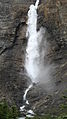
'''Takakkaw Falls''' ({{IPAEng|ˈtækəkɑ}}) is a [[waterfall]] located in [[Yoho National Park]], near [[Field, British Columbia|Field]], [[British Columbia]], in [[Canada]]. Its highest point is 384 m (1260 feet), making it the second-highest officially measured [[waterfall]] in western Canada, after [[Della Falls]] on [[Vancouver Island]]. However its true "free-fall" is only 254 m. |
||
"Takakkaw" is derived from the [[Cree language|Cree]] word for "it is wonderful". The falls are fed by the Daly [[ |
"Takakkaw" is derived from the [[Cree language|Cree]] word for "it is wonderful". The falls are fed by the Daly [[Glacier]], which keeps the volume of the falls up during the warm summer months, and are a tourist attraction, particularly in late spring after the heavy snow melts, when the falls are at peak condition. The Takakkaw Falls were featured in the [[1995 in film|1995 film]] ''[[Last of the Dogmen]]''. |
||
To reach the falls from the East, follow the [[Trans-Canada Highway]] for 23 km west of [[Lake Louise, Alberta|Lake Louise]] until Yoho Valley Road. When accessing from the West, drive 3.7 km east of Field on the [[Trans-Canada Highway]] and turn left on Yoho Valley Road. Follow this road for 13 km to the parking lot. A short [[hiking]] trail leads to the base of the falls. Note that Yoho Valley Road is narrow with two steep switchbacks and thus is not recommended for large [[Recreational vehicle|RVs]] or trailers. RVs over 8m (24 feet) must go up the second section of the switchbacks backwards. Information on how to do this is available at the information centre in Field. Trailers must be left at a designated drop-off point near the start of the road across from Monarch Campground. The road opens in late June (usually the last weekend in June) and closes for the year usually in October after the first heavy snowfall. The road is a [[ski]] trail for the rest of the year. The ski trail is maintained as far as the switchbacks, and is unmaintained above them. |
To reach the falls from the East, follow the [[Trans-Canada Highway]] for 23 km west of [[Lake Louise, Alberta|Lake Louise]] until Yoho Valley Road. When accessing from the West, drive 3.7 km east of Field on the [[Trans-Canada Highway]] and turn left on Yoho Valley Road. Follow this road for 13 km to the parking lot. A short [[hiking]] trail leads to the base of the falls. Note that Yoho Valley Road is narrow with two steep switchbacks and thus is not recommended for large [[Recreational vehicle|RVs]] or trailers. RVs over 8m (24 feet) must go up the second section of the switchbacks backwards. Information on how to do this is available at the information centre in Field. Trailers must be left at a designated drop-off point near the start of the road across from Monarch Campground. The road opens in late June (usually the last weekend in June) and closes for the year usually in October after the first heavy snowfall. The road is a [[ski]] trail for the rest of the year. The ski trail is maintained as far as the switchbacks, and is unmaintained above them. |
||
Revision as of 02:42, 16 August 2008

Takakkaw Falls (/ˈtækəkɑ/) is a waterfall located in Yoho National Park, near Field, British Columbia, in Canada. Its highest point is 384 m (1260 feet), making it the second-highest officially measured waterfall in western Canada, after Della Falls on Vancouver Island. However its true "free-fall" is only 254 m.
"Takakkaw" is derived from the Cree word for "it is wonderful". The falls are fed by the Daly Glacier, which keeps the volume of the falls up during the warm summer months, and are a tourist attraction, particularly in late spring after the heavy snow melts, when the falls are at peak condition. The Takakkaw Falls were featured in the 1995 film Last of the Dogmen.
To reach the falls from the East, follow the Trans-Canada Highway for 23 km west of Lake Louise until Yoho Valley Road. When accessing from the West, drive 3.7 km east of Field on the Trans-Canada Highway and turn left on Yoho Valley Road. Follow this road for 13 km to the parking lot. A short hiking trail leads to the base of the falls. Note that Yoho Valley Road is narrow with two steep switchbacks and thus is not recommended for large RVs or trailers. RVs over 8m (24 feet) must go up the second section of the switchbacks backwards. Information on how to do this is available at the information centre in Field. Trailers must be left at a designated drop-off point near the start of the road across from Monarch Campground. The road opens in late June (usually the last weekend in June) and closes for the year usually in October after the first heavy snowfall. The road is a ski trail for the rest of the year. The ski trail is maintained as far as the switchbacks, and is unmaintained above them.
-
 in July 2004
 -
 in July 2007
 -
 Crepuscular rays through mist from Takakkaw Falls
 -
 Daly Glacier and Takakkaw Falls from the Iceline Trail, July 16, 2005


