
Fall River Pass: Difference between revisions
Content deleted Content added
Replacing geodata: {{coord|40|26|26|N|105|45|17|W|type:pass|display=title}} |
m fmt coor |
||
| Line 6: | Line 6: | ||
| Location = [[Colorado]], [[United States]] |
| Location = [[Colorado]], [[United States]] |
||
| Range = [[Front Range]] |
| Range = [[Front Range]] |
||
| Coordinates = {{ |
| Coordinates = {{coord|40|26|26|N|105|45|17|W|type:pass}} |
||
| Topographic map = USGS Fall River Pass |
| Topographic map = USGS Fall River Pass |
||
| Transversed by = [[U.S. Highway 34]] |
| Transversed by = [[U.S. Highway 34]] |
||
Revision as of 13:56, 1 October 2008
| Fall River Pass |
|---|
Fall River Pass
Fall River Pass (el. 11,796 ft./3595 m.) is a mountain pass in the Rocky Mountains of northern Colorado in the United States. It is located on the in the Front Range, within Rocky Mountain National Park. The pass is traversed by U.S. Highway 34 on Trail Ridge Road between Estes Park and Granby. The pass is not, however, the high point on Trail Ridge Road, which crests at 12,183 ft east of the pass within Rocky Mountain National Park. The Alpine Visitor Center, one of five visitor centers for the National Park, is located at the pass. The pass has a moderately steep 6% grade on either side of the summit.
Picture Gallery
-
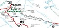 Map By USGS

-
 2.3 Miles High
 -
 Creek At Fall RIver Pass

