Front Range
| Front Range | ||
|---|---|---|
|
Longs Peak |
||
| Highest peak | Grays Peak ( 4350 m ) | |
| location | Colorado (USA) | |
| part of | Rocky mountains | |
|
|
||
| Coordinates | 39 ° 38 ′ N , 105 ° 49 ′ W | |
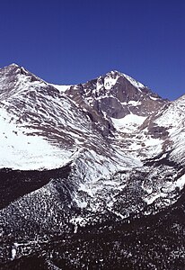
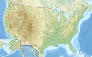
The Front Range [ ˈfɹʌnt ˌreɪndʒ ] (Eng. "Front Mountain Range") is a mountain range in the US state of Colorado that runs in a north-south direction .
The Front Range forms the eastern foothills of the Rocky Mountains and is separated from the Sangre de Cristo Range in the south by the Arkansas River . The northern boundary is less clear and is defined about 20 km from the state border with Wyoming , where the Front Range curves to the northwest into the Medicine Bow Mountains and to the northeast into the Laramie Mountains . To the west of the Rocky Mountains is predominantly the Colorado Plateau , while in the east of the "Rockies" are the steep slopes that form the continuous transition from the Rocky Mountains to the Great Plains . Within the Front Range there are also some smaller mountain ranges such as the Mummy Range as the northern Front Range at the transition to the Laramie Mountains and the Kenosha and Tarryall mountain ranges in the south .
In the Front Range , many of the best known US wildlife sanctuaries, including the lie Rocky Mountain National Park , the national forests Roosevelt , Arapaho and Pike and the Mount Evans Wildlife Reserve . Located at the foot of the mountain range also often abbreviated as FrontRange called Front Range Urban Corridor , in which between Pueblo in the south, through Colorado Springs , Denver and Fort Collins in the north on the border with Wyoming has almost settled the entire population of the state Colorado . The chain of settlements still extends across the border to Cheyenne .
The highest elevations in the Front Range
- Grays Peak (4,350 m)
- Torreys Peak (4,349 m)
- Mount Evans (4,348 m)
- Longs Peak (4,345 m)
- Pikes Peak (4,301 m)
- Mount Bierstadt (4,285 m)

