Arkansas River
The Arkansas River is a 2,364-kilometer tributary of the Mississippi in the United States of America .
course
It rises in the Sawatch Range of the Rocky Mountains at an altitude of about 4260 m near the small town of Leadville in central Colorado - about 130 kilometers southwest of Denver . It flows in an easterly direction through the Great Plains , passes, among others, Pueblo , Wichita , Tulsa and Little Rock , and then finally flows into the river of the same name at the state border with the US state of Mississippi .
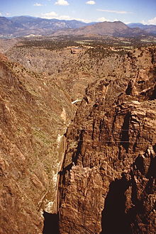
On the way from the Rocky Mountains down into the high plains of the Great Plains , the Arkansas River develops through rocky river bottoms and due to the steep slope into a raging river that passes many deep gorges. One of these gorges west of Cañon City is the Royal Gorge ("Royal Gorge") with the Royal Gorge Bridge - the highest suspension bridge in the world with a height of over 300 meters.
In the east of Colorado, near Las Animas , there is the John Martin Reservoir, the most important dam of the Arkansas River , which is intended to counteract the very different outflows of the river and thus prevent regular flooding. In Kansas , the Arkansas River eventually becomes more and more of a calm stream. In Oklahoma , in the valleys near the city of Tulsa , the Canadian River flows into it. Eventually he makes his way to the Mississippi through the Boston Mountains and Ouachita Mountains .
The river, whose catchment area covers 435,122 square kilometers, is navigable over a length of 1046 kilometers, up to the mouth of the Verdigris River below Tulsa. The Verdigris River is still navigable a few kilometers to Catoosa , where the US inland port with the greatest sea distance is located.
Name variants
The river has several designations:
- Acansas River
- Akansa River
- Akansas River
- Akansea River
- American Nile River
- Arcansa River
- Arcansas River
- Arcos River
- Ares River
- Arkansaw River
- Bazine
- Chinali River
- Kansas River
- La Riviere Des Akancas
- La Zorca River
- Ne Shudse
- Ne Shuta River
- Nigrette River
- Ok-a-na-sa
- Racket Sack River
- Red River
- Rio Napeste
- Rio Napestle
- Akansas River
- Riviere des Arcanssas
Cultural
Christo and Jeanne-Claude had been planning since 1999 to span part of the river between Canon City and Salida with fabric sheets. The approval process was well advanced, but the opponents of the project sued the US government because of the permits that had been granted, so that the project had to be postponed indefinitely. After Donald Trump was elected US President, Christo and Jeanne-Claude stopped the project in protest in January 2017.
See also
literature
- Max McCoy: Elevations: A Personal Exploration of the Arkansas River. University Press of Kansas, Lawrence 2018, ISBN 978-0-7006-2602-1 .
Web links
- Arkansas River ( English ) In: Geographic Names Information System . United States Geological Survey . Retrieved January 30, 2011.
Individual evidence
- ^ USGS - GNIS - Arkansas River
- ↑ Averaged USGS flow data for the Arkansas, Little Rock gauge , increased by the averaged flow values for the Bayou Meto flowing below, Lonoke gauge
- ↑ a b c d e f g Rydjord, John. Kansas Place Names , Norman, Okla: University of Oklahoma Press, 1972. Geographic Name Information including origins, organized by subject categories
- ↑ a b c d U.S. Geological Survey . Geographic Names Phase I data compilation (1976-1981). 31-Dec-1981. Primarily from US Geological Survey 1: 24,000-scale topographic maps (or 1: 25K, Puerto Rico 1: 20K) and from US Board on Geographic Names files. In some instances, from 1: 62,500 scale or 1: 250,000 scale maps
- ↑ Flores, Dan L., editor. Jefferson and Southwestern Exploration. Norman, Oklahoma: University of Oklahoma Press, 1984. p8
- ↑ a b c U.S. Geological Survey. Geographic Names Phase I data compilation (1976-1981). 31-Dec-1981. Primarily from US Geological Survey 1: 24,000-scale topographic maps (or 1: 25K, Puerto Rico 1: 20K) and from US Board on Geographic Names files. In some instances, from 1: 62,500 scale or 1: 250,000 scale maps
- ↑ Dugard, Rene C. Dictionary of French Place Names in the USA Editions Des Deux Mondes Et Slavuta, 1986, 431 pp. p9
- ^ Emporia Chamber of Commerce . City of Emporia, Kansas. np: n. d.
- ^ Arnold, Morris S. Colonial Arkansas, 1686-1804: A Social and Cultural History . Fayetteville, Arkansas: University of Arkansas Press, 1991. p190
- ^ A b McCoy, Sondra Van Meter and Jan Hults. 1001 Kansas Place Names . Lawrence, Ks .: University Press of Kansas, 1989, pp 223. p9
- ^ Allsop, Fred W. Folklore of Romantic Arkansas. 2 vols. New York, New York: Grolier Society, 1931. v1 / p45
- ^ Allsop, Fred W. Folklore of Romantic Arkansas . 2 vols. New York, New York: Grolier Society, 1931. v1 / p36
- ^ McCoy, Sondra Van Meter and Jan Hults. 1001 Kansas Place Names. Lawrence, Ks .: University Press of Kansas, 1989, pp 223. p9
- ↑ L'Isle Guillaume de. Carte de la Louisianurs du Mississipi, Atlas Nouveau, Contenant Toutes Les Parties du Monde, Ou font exactement Remarquees les Empires, Monarchies, Royaumes, Etats, Republiques, etc. , Amsterdam: chez Jean Covens and Corneille Mortier, 1733 (no scale). Provided an historical reference based presumably on French explorations
- ↑ Penicaut, Andre. Fleur de Lys and Calumet: Being the Penicaut Narrative of French Adventure in Louisiana. Translated and edited by Richebourg Gaillard McWilliams. Tuscaloosa, Alabama: University of Alabama Press, 1988. p34
- ↑ Christo, Trump and the Art World's Biggest Protest Yet New York Times, January 25, 2017.


