Cimarron River (Arkansas River)
| Cimarron River | ||
|
Upper reaches of the Cimarron River at Forgan, OK |
||
| Data | ||
| Water code | US : 1091369 | |
| location | New Mexico , Colorado , Oklahoma , Kansas (USA) | |
| River system | Mississippi River | |
| Drain over | Arkansas River → Mississippi River → Gulf of Mexico | |
| source | at Raton Pass in New Mexico 36 ° 54 ′ 24 ″ N , 102 ° 59 ′ 12 ″ W |
|
| muzzle | at Tulsa in Keystone Lake Coordinates: 36 ° 10 ′ 14 ″ N , 96 ° 16 ′ 19 ″ W 36 ° 10 ′ 14 ″ N , 96 ° 16 ′ 19 ″ W. |
|
| Mouth height |
220 m
|
|
| length | 1123 km | |
|
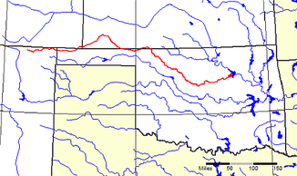
Course of the river (marked in red) |
||
The Cimarron River is the name of a river in the southwestern United States .
It has its source at Raton Pass in New Mexico and flows 1123 km before flowing into the Arkansas River at Tulsa, OK . Its name comes from the Spanish word for " mustang ".
The Cimarron River flows east into the Panhandle of Oklahoma , touches Colorado for only 15 km and reaches Kansas , where it first crosses the Cimarron National Grassland and then the Cimarron Desert . In these sections, the river occasionally dries up completely in the summer months. East of Liberal, KS , the river crosses the 37th parallel, which marks the border of Kansas and Oklahoma, several times before turning to the southeast and Oklahoma. At Tulsa it flows into the Arkansas River in the Keystone Lake reservoir . Because of its low water flow, the Cimarron River is not navigable and is not dammed.
In the middle of the 19th century , the variant of the Santa Fe Trail known as the Cimarron Cutoff , one of the most important trade routes in the early days of the Wild West , ran parallel to the river on the upper reaches between the New Mexico state border with Oklahoma and Ulysses, KS .

