Oklahoma Panhandle
The Oklahoma Panhandle (literally " pan handle of Oklahoma") is the western tip of the US state of Oklahoma . The region consists of the Cimarron , Texas and Beaver Counties from three counties lying in a west-east direction .
At the 2010 census , the area had 28,751 inhabitants, a decrease of 361 inhabitants compared to 2000 .
geography
The Oklahoma Panhandle is 166 miles (267 kilometers) long and 37 miles (60 kilometers) wide. It covers an area of 15,908 square kilometers (around 8 percent of the area of Oklahoma), making it larger than the state of Connecticut .
The Oklahoma Panhandle is bordered by Colorado in the north , New Mexico in the west, Texas in the south and the rest of Oklahoma in the east.
The largest city in the region is Guymon , the administrative seat of Texas County.
The Black Mesa , one to 1,737 meter high Table Mountain at the intersection of three states of Colorado, New Mexico and Oklahoma, reaches a height of 1,516 meters in the northwest of Cimarron County and is the highest point in Oklahoma.
The largest river that flows through the Oklahoma Panhandle is the Cimarron River , a tributary of Arkansas .
cities and communes
Most important cities
- Beaver (administrative seat of Beaver County )
- Boise City (administrative seat of Cimarron County )
- Goodwell (home of Oklahoma Panhandle State University )
- Guymon (administrative seat of Texas County and largest city in the Oklahoma Panhandle)
- Hooker
- Texhoma
More places
history
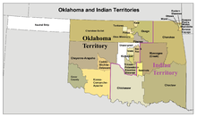
The area of what is now the Oklahoma Panhandle, then known as the Territory of Cimarron , was first settled by white ranchers around 1800. After the area remained largely unnoticed for a long time, an attempt was made in 1887 to establish an independent territorial government in Beaver. After this project failed at Congress , the area was incorporated into the Oklahoma Territory in 1890 .
Beaver County, which initially contained the entire area, was divided into three parts in 1907, at the same time as the state of Oklahoma was formed, and the county boundaries that still exist today were established in the Oklahoma Panhandle.
literature
- Harry E. Christman: Fifty Years on the Owl Hoot Trail: The First Sheriff of No Man's Land, Oklahoma Territory. Original manuscript by Jim Herron. Sage Books, Chicago 1969.
- Richard Lowitt: American Outback: The Oklahoma Panhandle in the Twentieth Century. Texas Tech University Press, 2006, ISBN 0-89672-558-8 .
Individual evidence
- ↑ United States Census 2010.Retrieved December 8, 2011.
- ↑ United States Census 2000 (addition of the numbers of all three counties). Retrieved December 8, 2011.
- ^ Encyclopedia.com - Territory of Cimarron. Retrieved December 8, 2011.
Web links
- Oklahoma article at HighBeam Encyclopedia.com ( December 10, 2006 memento in the Internet Archive )
- Oklahoma Panhandle was formerly called Cimarron Territory
- Cimarron Council of the Boy Scouts of America
- Oklahoma History Center: Education Programs
- Encyclopedia of Oklahoma History and Culture - Cimarron Territory
- TE Beck: Cimarron Territory. In: Chronicles of Oklahoma. 7, June 2, 1929, pp. 168-169.
- Counties of the Oklahoma Panhandle United States Census Bureau
- Morris L. Wardell: The History of No-Man's Land, or Old Beaver County. In: Chronicles of Oklahoma. 1, January 1, 1921, pp. 60-89.
Coordinates: 36 ° 45 ′ 0 ″ N , 101 ° 30 ′ 0 ″ W.


