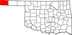
Cimarron County
![The Cimarron County Courthouse in Boise City, listed on the NRHP since 1984 [1]](https://upload.wikimedia.org/wikipedia/commons/thumb/6/69/Boise_City_Courthouse.JPG/298px-Boise_City_Courthouse.JPG) The Cimarron County Courthouse in Boise City, listed on the NRHP since 1984 |
|
| administration | |
|---|---|
| US state : | Oklahoma |
| Administrative headquarters : | Boise City |
| Address of the administrative headquarters: |
Cimarron County Courthouse P.O. Box 788 Boise City, Oklahoma 73933 |
| Foundation : | July 16, 1907 |
| Made up from: |
Beaver County Oklahoma Territory |
| Area code : | 001 580 |
| Demographics | |
| Residents : | 2475 (2010) |
| Population density : | 0.5 inhabitants / km 2 |
| geography | |
| Total area : | 4769 km² |
| Water surface : | 16 km² |
| map | |
The Cimarron County is a county in the US state of Oklahoma . At the 2010 census , the county had 2,475 people and a population density of 0.5 people per square kilometer. The county seat is Boise City .
geography
The county is very sparsely populated and is located at the far western end of the Oklahoma Panhandle , an approximately 60 kilometers wide strip that borders Texas to the south, New Mexico to the west and Kansas and Colorado to the north .
It is traversed by the upper reaches of the Cimarron River, which rises in New Mexico .
Cimarron County covers an area of 4,769 square kilometers, of which 16 square kilometers are water. It borders on the following counties:
|
Baca County (Colorado) |
Morton County, Kansas |
|
|
Union County, New Mexico |

|
Texas County |
|
Dallam County, Texas |
Sherman County, Texas |
history
Cimarron County was formed on July 16, 1907 from parts of Beaver County and former Indian land , also called No Man's Land . It was named after the Cimarron River that flows through the county.
The county has a National Historic Landmark , Camp Nichols . Eight structures and sites in the county are listed on the National Register of Historic Places (NRHP) (as of May 27, 2018).
Demographic data
| growth of population | |||
|---|---|---|---|
| Census | Residents | ± in% | |
| 1910 | 4553 | - | |
| 1920 | 3436 | -24.5% | |
| 1930 | 5408 | 57.4% | |
| 1940 | 3654 | -32.4% | |
| 1950 | 4589 | 25.6% | |
| 1960 | 4496 | -2% | |
| 1970 | 4145 | -7.8% | |
| 1980 | 3648 | -12% | |
| 1990 | 3301 | -9.5% | |
| 2000 | 3148 | -4.6% | |
| 2010 | 2475 | -21.4% | |
| 1900–1990 2000 2010 | |||
As of the 2010 census , there were 2,475 people in 1,167 households in Cimarron County. The population density was 0.5 inhabitants per square kilometer.
The racial the population was composed of 84.7 percent white, 0.2 percent African American, 0.8 percent Native American, 0.3 percent Asian and other ethnic groups; 1.8 percent were descended from two or more races. Hispanic or Latino of any race was 20.8 percent of the population.
Statistically, 2.27 people lived in the 1,167 households.
25.8 percent of the population were under 18 years old, 55.0 percent were between 18 and 64 and 19.2 percent were 65 years or older. 51.2 percent of the population was female.
The median income for a household was 32,186 USD . The per capita income was $ 18,364. 18.4 percent of the population lived below the poverty line.
cities and communes
Individual evidence
- ↑ Extract from the National Register of Historic Places - No. 84002988. Retrieved September 25, 2011
- ^ Cimarron County in the United States Geological Survey's Geographic Names Information System.Retrieved February 22, 2011
- ^ National Association of Counties.Retrieved September 25, 2011
- ↑ Listing of National Historic Landmarks by State: Oklahoma . National Park Service , accessed May 27, 2018.
- ↑ Search mask database in the National Register Information System. National Park Service , accessed May 27, 2018.
- ^ Extract from Census.gov.Retrieved February 28, 2011
- ↑ Excerpt from factfinder.census.gov.Retrieved February 28, 2011
- ↑ United States Census 2010.Retrieved September 25, 2011
- ^ US Census Bureau, State & County QuickFacts - Cimarron County. Retrieved September 25, 2011
Web links
- Encyclopedia of Oklahoma - Cimarron County
- US Census Bureau, State & County QuickFacts - Cimarron County
- Yahoo Image Search - Cimarron County
- www.city-data.com - Cimarron County
Coordinates: 36 ° 44 ′ N , 102 ° 31 ′ W


