Craig County, Oklahoma
![The Craig County Courthouse in Vinita, listed on the NRHP since 1984 [1]](https://upload.wikimedia.org/wikipedia/commons/thumb/0/03/Craig_County_Courthouse.jpg/298px-Craig_County_Courthouse.jpg) The Craig County Courthouse in Vinita, listed on the NRHP since 1984 |
|
| administration | |
|---|---|
| US state : | Oklahoma |
| Administrative headquarters : | Vinita |
| Address of the administrative headquarters: |
County Courthouse P.O. Box 397 Vinita, OK 74301-0397 |
| Foundation : | July 16, 1907 |
| Made up from: | Cherokee country |
| Area code : | 001 918 |
| Demographics | |
| Residents : | 15,029 (2010) |
| Population density : | 7.6 inhabitants / km 2 |
| geography | |
| Total area : | 1975 km² |
| Water surface : | 4 km² |
| map | |
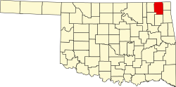
The Craig County is a county in the US state of Oklahoma . At the 2010 census , the county had 15,029 people and a population density of 7.6 people per square kilometer. The county seat is Vinita .
geography
The county is located almost in the extreme northeast of Oklahoma, borders Kansas to the north , is about 25 miles from Missouri to the east, and covers an area of 1,975 square kilometers, of which 4 square kilometers are water. It borders on the following neighboring counties:
|
Labette County, Kansas |
Cherokee County, Kansas |
|
| Nowata County |

|
Ottawa County |
| Rogers County | Mayes County | Delaware County |
history
The Craig County was formed on July 16, 1907 as the original county from Cherokee Country. It was named after Granville Craig , a prominent Cherokee at the time.
In 1871 two railway lines were built here: the Missouri, Kansas and Texas Railroad and the Atlantic and Pacific Railroad , which ran through the county and crossed at the district capital Vinita.
Ten buildings and sites in the county are listed on the National Register of Historic Places (NRHP) (as of May 28, 2018).
Events
Annually recurring events are the Will Rogers Memorial Rodeo in August, the Calf Fry Festival in September and the Oktoberfest in October, for which the festival of the same name in Munich serves as a template.
Demographic data
| growth of population | |||
|---|---|---|---|
| Census | Residents | ± in% | |
| 1910 | 17,404 | - | |
| 1920 | 19,160 | 10.1% | |
| 1930 | 18,052 | -5.8% | |
| 1940 | 21,083 | 16.8% | |
| 1950 | 18,263 | -13.4% | |
| 1960 | 16.303 | -10.7% | |
| 1970 | 14,722 | -9.7% | |
| 1980 | 15,014 | 2% | |
| 1990 | 14,104 | -6.1% | |
| 2000 | 14,950 | 6% | |
| 2010 | 15,029 | 0.5% | |
| 1900-1990 2000-2010 | |||
As of the 2010 census , Craig County had 15,029 people in 5,604 households. The population density was 7.6 inhabitants per square kilometer.
The racial the population was composed of 66.7 percent white, 3.0 percent African American, 20.4 percent Native American, 0.7 percent Asian and other ethnic groups; 8.5 percent were descended from two or more races. Regardless of ethnicity, 2.5 percent of the population was Hispanic or Latino of any race.
Statistically, 2.42 people lived in each of the 5,604 households.
22.7 percent of the population were under 18 years old, 59.9 percent were between 18 and 64 and 17.4 percent were 65 years or older. 49.2 percent of the population was female.
The median income for a household was 35,498 USD . The per capita income was $ 18,336. 20.2 percent of the population lived below the poverty line.
cities and communes
Individual evidence
- ↑ Extract from the National Register of Historic Places - No. 84002994.Retrieved January 5, 2012
- ↑ Craig County in the United States Geological Survey's Geographic Names Information System.Retrieved February 22, 2011
- ^ National Association of Counties.Retrieved January 5, 2012
- ↑ Search mask database in the National Register Information System. National Park Service , accessed May 28, 2018.
- ^ Extract from Census.gov.Retrieved February 28, 2011
- ↑ a b U.S. Census Bureau, State & County QuickFacts - Craig County, OK Retrieved January 5, 2012
Web links
- Encyclopedia of Oklahoma - Craig County
- Yahoo Image Search - Craig County
- www.city-data.com - Craig County
Coordinates: 36 ° 46 ′ N , 95 ° 13 ′ W
