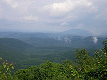
Ouachita Mountains
The Ouachita Mountains or Ouachitas (pronunciation [ wɑˈʃiɾə ], "wah-chi-tah") are a mountain range in western central Arkansas and southeastern Oklahoma ( Kiamichi Country ). Below the surface they may continue to central Texas , maybe even further to the Marathon Uplift . Together with the Ozark Mountains , the Ouachita Mountains form the area of the US Interior Highlands , the only major mountainous area between the Rocky Mountains in the west and the Appalachians in the east. Its highest peak is Mount Magazine with a height of 839 m.
Geology and surface shape
The Ouachita Mountains are part of the Ouachita physiogeographic region , which includes both the Ouachita Mountains and the Arkansas River valley and is in turn part of the larger US Interior Highlands .
The Ouachita Mountains are an ancient fold mountains, similar to the Appalachians further to the northeast. Both mountain ranges were connected more than 250 million years ago and were themselves part of an even more extensive mountain range. During the Pennsylvania ( Upper Carboniferous ), about 300 million years ago, North America and Europe were united into a major continent called Laurussia . The seam ran between today's Norway and Greenland. The coastline of the predecessor of today's Gulf of Mexico ran across Arkansas. The ocean basin off the Arkansas continental shelf was not yet the Atlantic, but the so-called Rheic Ocean . A subduction zone was located there through the north drift of western Gondwana (today the South American plate ) . The Gondwanian oceanic crust was pushed under the less dense continental crust on the southern edge of the western part of Laurussia. The final collision of West Laurussia with West Gondwana and the associated tectonic deformation of the continental crust ( folds and thrusts ) is called the Ouachita orogeny . Viewed globally, it is only one of numerous mountain formations in the Upper Carboniferous. At the time of their creation, the Ouachitas were high mountains, about comparable in height to today's Rocky Mountains. Due to the age of the ouachitas, the high peaks have long been worn away. Today there are only low ranges of hills that once formed the interior of the mountains.
Unlike most of the other mountain ranges in the United States, the ouachitas run in an east-west direction rather than north-south. In addition, they are characterized by the fact that they do not have any volcanic rocks , metamorphic rocks or igneous intrusive rocks . However, they are known for the occurrence of quartz crystals, approximately around the city Mount Ida find and deposits of Arkansas novaculite - whetstone ( Arkansas ).
Flora
The Ouachita Mountains are home to at least 15 endemic plant species, including Sabatia arkansana , Valerianella nuttallii , Liatris compacta, and Quercus acerifolia .
tourism
The Ouachita Mountains include the Ouachita National Forest and the Hot Springs National Park, as well as numerous state parks and scenic back roads. The Ouachita National Recreation Trail , an approximately 360 km hiking trail through the heart of the mountain landscape, connects Talimena State Park in Oklahoma with Pinnacle Mountain State Park near Little Rock , Arkansas. It is a well-maintained trail for hikers and parts of it are also accessible to mountain bikers.
During the Civil War in 1863, the Battle of Devil's Backbone was fought in the Ouachita Mountains on the mountain ridge of the same name.
Individual evidence
- ^ Ouachita National Forest. In: United States Department of Agriculture. Physiographic Regions ( Memento of May 9, 2008 in the Internet Archive ). In: A Tapestry of Time and Terrain: The Union of Two Maps - Geology and Topography. United States Geological Survey (English). See also Ouachita and Ozark Plateaus. In: National Park Service , Series: Physiographic Provinces.
- ^ Physiographic divisions of the conterminous US . US Geological Survey. Retrieved December 6, 2007.
- ↑ James S. Pringle, Theo Whitsell: A new species of Sabatia (Gentianaceae) from Saline County, Arkansas. In: Sida. Volume 21, 2005, No. 3, pp. 1249-1262 (PDF).
Web links
geology
- James S. Aber: Ouachita Mountains. Course GO 568, Structural Geology, Emporia State University, Kansas (English)
- James B. Calvert: The Ouachita System. University of Denver, 2003 (English)
- The Formation of the Ouachita Mountains. In: Rockhoudingar.com (English; on geology).
tourism
- Friends of the Ouachita Trail (FoOT). Association for the Promotion of the Ouachita National Recreation Trail (English)
- USDA Forest Service - Ouachita National Forest (English)
Coordinates: 34 ° 30 ′ N , 94 ° 30 ′ W


