Payang Town: Difference between revisions
Content deleted Content added
Dr. Blofeld (talk | contribs) No edit summary |
Dr. Blofeld (talk | contribs) No edit summary |
||
| Line 1: | Line 1: | ||
[[File:Paryang.jpg|thumb|360px|Paryang]] |
[[File:Paryang.jpg|thumb|360px|Paryang]] |
||
'''Paryang''' is a |
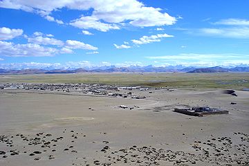
'''Paryang''' is a village and township in the [[Tibet Autonomous Region]] of [[China]] under [[Zhongpa County]]. It is about a 7-hour drive from [[Saga County]] and one of the popular stops for a [[Mount Kailash]] trip. Most of the local residents are migrant nomads from its neighboring villages situated below Dangue Tsangpo. |
||
==Villages== |
==Villages== |
||
Revision as of 11:42, 14 May 2015

Paryang is a village and township in the Tibet Autonomous Region of China under Zhongpa County. It is about a 7-hour drive from Saga County and one of the popular stops for a Mount Kailash trip. Most of the local residents are migrant nomads from its neighboring villages situated below Dangue Tsangpo.
Villages
Some of villages under Paryang township:
- Dakdokarchung
- Namozaema
- Tsempu
- Toonla
