Xigazê
| Tibetan name |
|---|
|
Tibetan script :
གཞིས་ ཀ་ རྩེ་
|
|
Wylie transliteration : gzhis ka rtse
|
|
Pronunciation in IPA : [
ɕìːkəʦe ]
|
|
Official transcription of the PRCh : Xigazê
|
|
THDL transcription : Zhikatsé
|
|
Other spellings: Shigatse, Shikatse, Schigatse, Schigatze, Digardschi, Dschigatzi etc.
|
| Chinese name |
|
Traditional :
日喀則
|
|
Simplified :
日喀则
|
|
Pinyin : Rìkāzé
|
Xigazê (Shigatse) has been the second prefecture-level city in the Tibet Autonomous Region of the People's Republic of China since June 26, 2014, alongside Lhasa . It emerged from the former administrative district of Xigazê.
designation
Xigazê essentially depicts the space that made up the cultural province or region of Tsang (Tib .: gtsang ) in traditional Tibet . The Chinese name for the Tibetans in general is derived from this name: "Zang". Together with the central cultural province Ü (tib .: dbus ) around the capital Lhasa, 'Wusi-Zang' ( Hanyu Pinyin for tib .: dbus gtsang ) or later 'Wei-Zang' (for Ü- Tsang ) referred to central Tibet. The different pronunciations reflect sound shifts that have taken place in Tibetan over the past 600 years. The term 'Zang' has remained both for Tibetans in general and for western central Tibet, which is administered from Xigazê. The Chinese term Xizang, derived from it, is valid for the autonomous region of Tibet .
geography
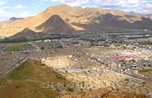
The city of Xigazê is located in the southwest of the Tibet Autonomous Region in the People's Republic of China . Its seat of government is in the district of Samzhubzê .
With 17 districts and a city district, Xigazê has an area of approx. 176,000 km² and 703,292 inhabitants (2010 census).
In Xigazê, agriculture is possible , especially in the valleys around the main river Yarlung Zangbo (Yarlung Tsangpo). Mainly highland barley and wheat , but also potatoes and rapeseed are grown there. In large areas in the north and west of the city, only nomadic grazing can provide a livelihood, with mainly yaks being kept , but also sheep and goats in drier zones in the west. Traditionally, trade in the centers of the region, Samzhubzê and Gyangzê , played a major role.
Trashilhünpo Monastery
In the west of the city lies the large monastery complex of Trashilhünpo , which was destroyed during the Cultural Revolution and slowly rebuilt from the 1980s onwards.
Administrative division of the city of Xigazê
At the district level, Xigazê is made up of a city district and 17 districts . These are:
| Surname | Tibetan | Wylie | Chinese | Pinyin |
|---|---|---|---|---|
| Samzhubzê municipality | བསམ་ འགྲུབ་ རྩེ་ ཆུས ། | bsam 'grub rtse | 桑 珠 孜 区 | Sāngzhūzī Qū |
| circle Namling | རྣམ་ གླིང་ རྫོང་ | rnam gling rdzong | 南 木林 县 | Nánmùlín Xiàn |
| Gyangzê County | རྒྱལ་ རྩེ་ རྫོང་ | rgyal rtse rdzong | 江孜 县 | Jiāngzī Xiàn |
| Tingri County | དིང་ རི་ རྫོང་ | ding ri rdzong | 定日 县 | Dìngrì Xiàn |
| Sa'gya County | ས་ སྐྱ་ རྫོང་ | sa skya rdzong | 萨迦 县 | Sàjiā Xiàn |
| Lhazê County | ལྷ་ རྩེ་ རྫོང་ | lha rtse rdzong | 拉孜 县 | Lāzī Xiàn |
| Ngamring Circle | ངམ་ རིང་ རྫོང་ | ngam ring rdzong | 昂 仁 县 | Ángrén Xiàn |
| circle xaitongmoin county | བཞད་ མཐོང་ སྨོན་ རྫོང་ | bzhad mthong smon rdzong | 谢 通 门 县 | Xiètōngmén Xiàn |
| Bainang County | པ་ སྣམ་ རྫོང་ | pa snam rdzong | 白朗 县 | Báilǎng Xiàn |
| Circle rinbung | རིན་ སྤུངས་ རྫོང་ | rin spungs rdzong | 仁 布 县 | Rénbù Xiàn |
| circle Kangmar | ཁང་ དམར་ རྫོང་ | khang dmar rdzong | 康马 县 | Kāngmǎ Xiàn |
| Dinggyê County | གདིང་ སྐྱེས་ རྫོང་ | gding skyes rdzong | 定 结 县 | Dìngjié Xiàn |
| circle Zhongba | འབྲོང་ པ་ རྫོང་ | 'brong pa rdzong | 仲巴 县 | Zhòngbā Xiàn |
| Yadong County | གྲོ་ མོ་ རྫོང་ | gro mo rdzong | 亚东 县 | Yàdōng Xiàn |
| circle Gyirong | སྐྱིད་ གྲོང་ རྫོང་ | skyid grong rdzong | 吉隆 县 | Jílóng Xiàn |
| Nyalam County | གཉའ་ ལམ་ རྫོང་ | gnya 'lam rdzong | 聂拉木 县 | Nièlāmù Xiàn |
| Circle saga | ས་ དགའ་ རྫོང་ | sa dga 'rdzong | 萨嘎 县 | Sàgà Xiàn |
| Gamba district | གམ་ པ་ རྫོང་ | gam pa rdzong | 岗 巴 县 | Gǎngbā Xiàn |
traffic
The extension of the Lhasa Railway from Lhasa to Xigazê has been in operation since August 15, 2014. It has the name Lhasa-Xigazê-Bahn or Lari-Bahn for short (abbreviation : 拉 日 铁路; Pinyin: Lārì Tiělù; Tibetan: lha gzhis lcags lam ལྷ་ གཞིས་ ལྕགས་ ལམ་). The train travels through 29 tunnels, including a 10,410 meter long tunnel at an altitude of 3,850 meters. Due to its height, the Chinese media also call the railway line the sky path (天 路 Tiānlù).
literature
- Xú Píng 徐 平: Rìkāzé日喀则 (Beijing, Wǔzhōu chuánbō chūbǎnshè 五洲 传播 出版社 2000), ISBN 7-80113-396-X .
Web links
Footnotes
- ↑ z. B. in Melvyn C. Goldstein : A History of Modern Tibet. The Calm Before the Storm. 1951-1955 , 2007.
- ↑ z. B. in H. A. Jäschke : A Tibetan-English Dictionary , 1882 and in Nicolas Tournadre, Sangda Dorje: Manual of Standard Tibetan. Language and Civilization , 2003, p. 475.
- ↑ z. B. in Sven Hedin : Transhimalaya , 1909.
- ↑ z. B. in H. F. Hackmann: Der Buddhismus , 1906.
- ↑ z. B. in Meyers Konversations-Lexikon , 1897.
- ↑ z. B. Pierer's Universal Lexicon of the Past and Present , 1857.
Coordinates: 29 ° 16 ' N , 88 ° 53' E

