Ihwa-dong, Seoul: Difference between revisions
Content deleted Content added
Rescuing 0 sources and tagging 1 as dead. #IABot (v2.0beta9) |
No edit summary |
||
| Line 1: | Line 1: | ||
{{Infobox |
{{Infobox settlement |
||
<!-- See Template:Infobox settlement for additional fields and descriptions --> |
|||
| ⚫ | |||
| |
| name = Ihwa-dong |
||
| ⚫ | |||
| imgwidth = |
|||
| translit_lang1_type = [[Hangul]] |
|||
| ⚫ | |||
| |
| translit_lang1_info = 이화동 |
||
| translit_lang1_type1 = [[Hanja]] |
|||
| |
| translit_lang1_info1 = {{linktext|梨|花|洞}} |
||
| ⚫ | |||
| translit_lang1_type2 = {{nowrap|[[Revised Romanization of Korean|Revised Romanization]]}} |
|||
| ⚫ | |||
| ⚫ | |||
| ⚫ | |||
| translit_lang1_type3 = {{nowrap|[[McCune–Reischauer]]}} |
|||
| ⚫ | |||
| translit_lang1_info3 = Ihwa tong |
|||
| ⚫ | |||
| |
| translit_lang2 = |
||
| |
| translit_lang2_type = [[Hangul]] |
||
| |
| translit_lang2_info = |
||
| |
| translit_lang2_type1 = [[Hanja]] |
||
| |
| translit_lang2_info1 = |
||
| translit_lang2_type2 = {{nowrap|[[Revised Romanization of Korean|Revised Romanization]]}} |
|||
|mapcaption = |
|||
| translit_lang2_info2 = |
|||
| translit_lang2_type3 = {{nowrap|[[McCune–Reischauer]]}} |
|||
| translit_lang2_info3 = |
|||
| image_skyline = File:P00250516 114459479 이화동주민센터.JPG |
|||
| imagesize = |
|||
| image_alt = |
|||
| ⚫ | |||
| image_map = |
|||
| mapsize = |
|||
| map_alt = |
|||
| map_caption = |
|||
| pushpin_map = <!-- name of a location map, can be North Korea, South Korea or South Korea Seoul --> |
|||
| pushpin_label = <!-- only necessary if "name" or "official_name" are too long --> |
|||
| coordinates = |
|||
| coor_pinpoint = <!-- to specify exact location of coordinates (was coor_type) --> |
|||
| subdivision_type = Country |
|||
| subdivision_name = [[South Korea]] |
|||
| subdivision_type1 = [[Regions of Korea|Region]] |
|||
| subdivision_name1 = |
|||
| seat_type = Capital |
|||
| ⚫ | |||
| parts_type = |
|||
| parts_style = para |
|||
| ⚫ | |||
| government_type = |
|||
| leader_title = Mayor |
|||
| leader_name = |
|||
| area_footnotes = |
|||
| ⚫ | |||
| elevation_footnotes = |
|||
| elevation_m = |
|||
| ⚫ | |||
| population_total = 11722 |
|||
| population_as_of = 2001 |
|||
| population_density_km2 = auto |
|||
| blank_name_sec1 = [[Korean dialects|Dialect]] |
|||
| blank_info_sec1 = |
|||
| footnotes = |
|||
}} |
}} |
||
Revision as of 11:03, 28 May 2019
Ihwa-dong | |
|---|---|
| Korean transcription(s) | |
| • Hangul | 이화동 |
| • Hanja | 梨花洞 |
| • Revised Romanization | Ihwa dong |
| • McCune–Reischauer | Ihwa tong |
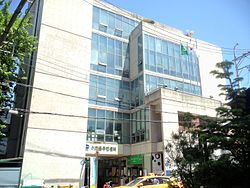
 Ihwa-dong Community Service Center (Jongno-gu) | |
| Country | South Korea |
| Area | |
| • Total | 0.78 km2 (0.30 sq mi) |
| Population (2001)[1] | |
| • Total | 11,722 |
| • Density | 15,000/km2 (39,000/sq mi) |
Ihwa-dong is a dong, neighbourhood of Jongno-gu in Seoul, South Korea.[1][2]

See also
References
- ^ a b "이화동 (Ihwa-dong 梨花洞)" (in Korean). Doosan Encyclopedia. Retrieved 2008-04-23.[permanent dead link]
- ^ "Origin of Ihwa-dong's name" (in Korean). Jongno-gu official site. Archived from the original on 2004-08-20. Retrieved 2008-04-23.
{{cite web}}: Unknown parameter|dead-url=ignored (|url-status=suggested) (help)
- "종로구 (Jongno-gu 鍾路區)" (in Korean). Doosan Encyclopedia. Retrieved 2008-04-22.[permanent dead link]
- "Chronicle of Beopjeong-dong and Haengjeong-dong" (in Korean). Guro-gu Official website.
- "Mapo Information". The chart of Beopjeong-dong assigned by Haengjeong-dong (행정동별 관할 법정동 일람표) (in Korean). Mapo-gu Official website. Archived from the original on 2007-11-05.
{{cite web}}: Unknown parameter|dead-url=ignored (|url-status=suggested) (help)

