RAF Stradishall
RAF Stradishall | |||||||||||||||||||
|---|---|---|---|---|---|---|---|---|---|---|---|---|---|---|---|---|---|---|---|
 Latin: Vires de caelo ("Might from the sky") | |||||||||||||||||||
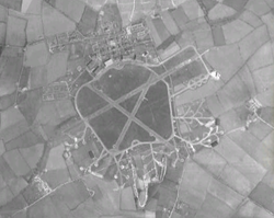
 Aerial view in 1945 | |||||||||||||||||||
| Summary | |||||||||||||||||||
| Airport type | Military | ||||||||||||||||||
| Owner | Ministry of Defence | ||||||||||||||||||
| Operator | Royal Air Force | ||||||||||||||||||
| Location | Stradishall, Suffolk | ||||||||||||||||||
| Built | 1937 | ||||||||||||||||||
| In use | 1938-1970 | ||||||||||||||||||
| Elevation AMSL | 381 ft / 116 m | ||||||||||||||||||
| Coordinates | 52°08′06″N 000°30′51″E / 52.13500°N 0.51417°E | ||||||||||||||||||
| Map | |||||||||||||||||||
| Runways | |||||||||||||||||||
| |||||||||||||||||||
Royal Air Force Stradishall or more simply RAF Stradishall is a former Royal Air Force station located 4.7 miles (7.6 km) north east of Haverhill, Suffolk and 9 miles (14 km) south west of Bury St Edmunds, Suffolk, England. Part of the site remains in use as Stradishall Training Area.[1]
History
In his memoirs,[2] Murray Peden, a Royal Canadian Air Force pilot, recounts his training at Stradishall. In the RAF's "heavy conversion unit" (No. 1657 Heavy Conversion Unit[3]) at the airfield, he and others were trained to fly Short Stirling bombers. He describes in detail his experiences flying there, and the life on the ground of aircrew who were shortly to begin operations over Nazi Germany as part of RAF Bomber Command during World War II.
The airfield was home to a number of squadrons during its lifetime:
- No. 1 Squadron RAF,[4] No. 9 Squadron RAF,[5] No. 35 Squadron RAF,[6] No. 51 Squadron RAF,[7] No. 54 Squadron RAF,[8] No. 75 Squadron RAF,[9] No. 85 Squadron RAF,[10] No. 89 Squadron RAF.[10]
- No. 101 Squadron RAF,[11] No. 109 Squadron RAF,[12] No. 115 Squadron RAF,[13] No. 125 Squadron RAF,[14] No. 138 Squadron RAF,[15] No. 148 Squadron RAF,[16] No. 149 Squadron RAF,[16] No. 150 Squadron RAF,[16] No. 152 Squadron RAF,[17] No. 158 Squadron RAF,[17] No. 186 Squadron RAF.[18]
- No. 207 Squadron RAF,[19] No. 208 Squadron RAF,[19] No. 214 Squadron RAF,[20] No. 215 Squadron RAF,[20] No. 236 Squadron RAF,[21] No. 245 Squadron RAF,[22] No. 254 Squadron RAF,[23] No. 263 Squadron RAF.[24]
- No. 311 Squadron RAF.[25]

Current use
The airfield closed in 1970 and is now the site of two category C prisons: HMP Highpoint North and HMP Highpoint South. Part of the former airfield remains a Ministry of Defence training site which is not accessible to the public.
The airfield has been sold to a private buyer to be converted into farm land and is out of bounds to the public.
Update 2021: The Airfield is now a Solar Farm with grazing for cattle and nature walk. It is open from dawn to dusk.
There is a memorial to RAF Stradishall outside Stirling House which was once part of the officers quarters and is now a training unit for the Prison service.
References
Citations
- ^ "DTE East Public Information Leaflet" (PDF). Retrieved 16 December 2020.
- ^ Peden, Murray, "A Thousand Shall Fall," Dundurn (1 April 2003)
- ^ Sturtivant, Ray; Hamlin, John F. (2007). RAF Flying Training And Support Units since 1912. Tonbridge, Kent, UK: Air-Britain (Historians) Ltd. ISBN 0-85130-365-X.
- ^ Jefford 1988, p. 23.
- ^ Jefford 1988, p. 27.
- ^ Jefford 1988, p. 37.
- ^ Jefford 1988, p. 41.
- ^ Jefford 1988, p. 42.
- ^ Jefford 1988, p. 48.
- ^ a b Jefford 1988, p. 51.
- ^ Jefford 1988, p. 54.
- ^ Jefford 1988, p. 55.
- ^ Jefford 1988, p. 57.
- ^ Jefford 1988, p. 58.
- ^ Jefford 1988, p. 60.
- ^ a b c Jefford 1988, p. 62.
- ^ a b Jefford 1988, p. 63.
- ^ Jefford 1988, p. 66.
- ^ a b Jefford 1988, p. 69.
- ^ a b Jefford 1988, p. 71.
- ^ Jefford 1988, p. 75.
- ^ Jefford 1988, p. 77.
- ^ Jefford 1988, p. 79.
- ^ Jefford 1988, p. 80.
- ^ Jefford 1988, p. 85.
Bibliography
- Jefford, C.G. RAF Squadrons, a Comprehensive Record of the Movement and Equipment of all RAF Squadrons and their Antecedents since 1912. Shrewsbury, Shropshire, UK: Airlife Publishing, 1988. ISBN 1-84037-141-2.

