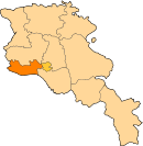
Margara
Appearance
40°02′01″N 44°10′26″E / 40.03361°N 44.17389°E
Margara
Մարգարա | |
|---|---|
| Coordinates: 40°02′01″N 44°10′26″E / 40.03361°N 44.17389°E | |
| Country | Armenia |
| Marz (Province) | Armavir |
| Population (2008) | |
| • Total | 1,477 |
| Time zone | UTC+4 ( ) |
| • Summer (DST) | UTC+5 ( ) |

Margara (Armenian: Մարգարա, also Romanized as Markara; formerly Margara-Gök) is a town in the Armavir Province of Armenia. Margara is the closest border crossing to Turkey from Yerevan, though at present the border is closed. The town is located on the other side of Alican. Margara has a road bridge across the Arax River to Turkey. The Border Guard Service of Russia patrols the closed border between Armenia and Turkey.
History
In 2023, the border crossing briefly reopened to allow the passage of humanitarian aid following the Turkey–Syria earthquake for the first time since 1988.[1]
See also
References
- ^ "Armenia-Turkey border crossing opened for first time in 35 years after massive quake". AFP via Al Arabiya. 11 February 2023. Retrieved 13 February 2023.
- Margara at GEOnet Names Server
- World Gazeteer: Armenia[dead link] – World-Gazetteer.com
- Report of the results of the 2001 Armenian Census, Statistical Committee of Armenia
- Kiesling, Brady (June 2000). Rediscovering Armenia: An Archaeological/Touristic Gazetteer and Map Set for the Historical Monuments of Armenia (PDF). Archived (PDF) from the original on 6 November 2021.
External links


