Sargasso Sea

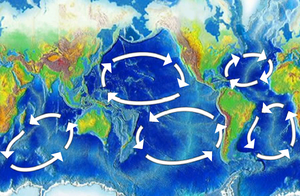
The Sargasso Sea is an elongated region in the middle of the North Atlantic Ocean, surrounded by ocean currents. On the west it is bounded by the Gulf Stream. On the north, by the North Atlantic Current; on the east, by the Canary Current; and on the south, by the North Atlantic Equatorial Current. This system of currents forms the North Atlantic Subtropical Gyre.
The Sargasso is roughly 700 statute miles wide and 2,000 statute miles long (1,100 km wide and 3,200 km long). It stretches from roughly 70 degrees west to 40 degrees west, and from 25 degrees north to 35 degrees north. Bermuda is near the western fringes of the sea. The Sargasso Sea is the only "sea" without shores[1].
History
Portuguese sailors were among the first to discover this region in the 15th century, although it may have been known to earlier mariners, as a poem by the late 4th century AD author Rufus Festus Avienus describes a portion of the Atlantic as being covered with seaweed. Christopher Columbus and his men also noted the Sargasso Sea, and brought reports of the masses of seaweed on the surface.
Connection to Bermuda Triangle
Due to its proximity to Bermuda (and being in the Bermuda Triangle), the sea is credited with some of the infamous disappearances there. That stigma is further enforced by the sometimes total lack of wind over the sea, and the possibility for modern engines to become entangled in the sargassum, stranding most vessels. Thus, it is sometimes called the "graveyard of ships."
Ecology
The very salty Sargasso Sea is sometimes regarded as being lifeless[citation needed], though it is home to some seaweed of the genus Sargassum. This seaweed floats en masse on the surface there. The Sargasso Sea also plays a major role in the migration of the European eel and the American eel. The larvae of both species hatch there and go to Europe and/or the East Coast of North America. Later in life, they try to return to the Sargasso Sea to lay eggs. It is also believed that after hatching, young Loggerhead Sea Turtles use currents such as the Gulf Stream to travel to the Sargasso Sea where they use the Sargassum as cover from predation until they are mature.[2]
The Sargasso Sea was the subject of a recent metagenomics effort called the Global Ocean Sampling (GOS) survey, by J. Craig Venter and others, to evaluate the diversity of microbial life there. The results have indicated that, unlike previously thought, the area has a wide variety of prokaryotic life.
Due to surface currents, the Sargasso accumulates a higher concentration of non-biodegradable plastic waste.[3] This huge vortex of garbage is similar to the famed Great Pacific Garbage Patch.
Folklore
The Sargasso Sea is often portrayed in literature and the media as an area of mystery.[4] It can be depicted as "sea within a sea" in the midst of the freezing Northern Atlantic ocean. Whirlpool-like currents and/or the seaweed are meant to becalm ships, while other forces can even lead to the disappearance of airplanes in the segment of it that is called the Bermuda Triangle. Edwin Corley's novel Sargasso revolves around Apollo 19 splashing down in the Sargasso sea empty.
References
- ^ http://web.mac.com/flintartsed/Homeschool/artreachresources_files/AR2_2_Oct07.pdf Flint Institute of Arts Vol 2 No 2
- ^ http://news.bbc.co.uk/1/hi/sci/tech/7477519.stm
- ^ "The trash vortex". Greenpeace. Retrieved 2008-04-20.
- ^ Ruth Heller (2000). A Sea Within a Sea: Secrets of the Sargasso. Price Stern Sloan. ISBN 978-0448424170.

