Shire of Mingenew
| Shire of Mingenew Western Australia | |||||||||||||||
|---|---|---|---|---|---|---|---|---|---|---|---|---|---|---|---|
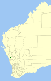
 Location in Western Australia | |||||||||||||||
| Population | 471 (2006 census) | ||||||||||||||
| • Density | Lua error: Unable to convert population "471 (2006 census)" to a number. | ||||||||||||||
| Area | 1,939.4 km2 (748.8 sq mi) | ||||||||||||||
| Mayor | Michelle Bagley | ||||||||||||||
| Council seat | Mingenew | ||||||||||||||
| Region | Mid West | ||||||||||||||
| State electorate(s) | Moore | ||||||||||||||
| Federal division(s) | O'Connor | ||||||||||||||
| Website | Shire of Mingenew | ||||||||||||||
| |||||||||||||||
The Shire of Mingenew is a Local Government Area in the Mid West region of Western Australia, about 110 kilometres (68 mi) southeast of the city of Geraldton and about 370 kilometres (230 mi) north of the state capital, Perth. The Shire covers an area of 1,939 square kilometres (749 sq mi), and its seat of government is the town of Mingenew.
History
The Shire of Mingenew was initially constituted as the Upper Irwin Road Board in 1901, over a much larger area. By 1919, it had adopted for the most part its present area and was renamed to the Mingenew Road Board. On 1 July 1961, it became a Shire Council following changes to the Local Government Act. [1]
Wards
Since 2005, the shire has been divided into wards. Prior to this, a 5-ward system was in place with the Town Ward having 3 councillors and the remaining wards one each.
- Rural Ward (3 councillors)
- Town Ward (4 councillors)
Towns/Localities
References
- ^ WA Electoral Commission, Municipality Boundary Amendments Register (release 2.0), 31 May 2003.
External links
Template:Local Government Areas of Mid West Western Australia
