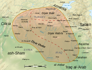
Diyar Mudar

Diyār Mudar ("abode of Mudar") is the medieval Arabic name of the westernmost of the three provinces of the Jazira (Upper Mesopotamia), the other two being Diyar Bakr and Diyar Rabi'a. According to al-Baladhuri, all three provinces were named after the main Arab tribes that were settled there by Mu'awiyah in the course of the Muslim conquests of the 7th century. The Diyar Mudar was settled by the Mudar tribe.
Diyar Mudar encompasses the region on both banks of the middle course of the river Euphrates, from the area of Samosata to the town of Anah, and includes the are of the river Balikh and the lower reaches of the river Khabur. Its main cities al-Raqqah in the south and Edessa (al-Ruha in Arabic) in the north, and other major cities included Harran, and Saruj. Geographically and politically, in early Islamic times the Diyar Mudar was usually part of the Jazira. In the mid-10th century, the region came under Hamdanid control, and under Sayf al-Dawla. After the loss of control of the Hamdanids, the Diyar Mudar and its cities were under ther sway of the Banu Numayr At latest in 392/1002 Waththab ibn Ja'bar al-Numayri became autonomous governor of Harran, while Edessa was conquered by the resurgent Byzantine empire in 1032. Thereafter the region became divided into a mostly Christian-ruled northern portion, subject to Armenian colonization, and an Arab-nomad part from Harran to the Eupharetes. Seljuq raids began in the 1060s and 1070s, but it was not until 1086 that the Seljuq sultan Malikshah unified the province under his control. The advent of the Crusades re-established the division between a Christian north (the County of Edessa) and a Muslim south, which lasted until the mid-12th century. The Ayyubids gained control of the region under Saladin, and kept it until the Mongol conquest in 1260.
Sources
- Canard, Marius; Cahen, Claude (1991). "Diyār Bakr". The Encyclopedia of Islam, New Edition, Volume II: C–G. Leiden and New York: Brill. pp. 343–345. ISBN 90-04-07026-5.
{{cite encyclopedia}}: Invalid|ref=harv(help) - Canard, Marius; Cahen, Claude (1991). "Diyār Mudar". The Encyclopedia of Islam, New Edition, Volume II: C–G. Leiden and New York: Brill. pp. 347–348. ISBN 90-04-07026-5.
{{cite encyclopedia}}: Invalid|ref=harv(help) - Heidemann, Stefan (2002). Die Renaissance der Städte in Nordsyrien und Nordmesopotamien. Städtische Entwicklung und wirtschaftliche Bedingungen in ar-Raqqa und Harrān von der Zeit der beduinischen Vorherrschaft bis zu den Seldschuken. Islamic History and Civilization Studies and Texts 40 (in German). Leiden et al.: Brill.
- Heidemann, Stefan (2011). "The Agricultural Hinterland of Baghdad, al-Raqqa and Samarra': Settlement Patterns in the Diyar Muḍar.". Le Proche-Orient de Justinien aux Abbasides. Peuplement et dynamiques spatiales. Actes du colloque «Continuites de l'occupation entre les periodes byzantine et abbasside au Proche-Orient, VIe-IXe siecles» Paris, 18-20 octobre 2007. Bibliothèque de l’antiquitè tardive 19. Turnhout: Brepols. pp. 43–58.
