
Väsman
| Lake Väsman | |
|---|---|
 Lake Väsman with Ludvika in the background | |
| Location | Dalarna County, Ludvika Municipality |
| Coordinates | 60°11′08″N 15°04′23″E / 60.18554°N 15.07306°E |
| Type | Lake |
| Catchment area | 1147.86 |
| Basin countries | Sweden |
| Surface area | 39.1 |
| Max. depth | 53 |
| Shore length1 | 69.4 |
| Surface elevation | 154 |
| Islands | Sollen, Granön |
| Settlements | Ludvika |
| 1 Shore length is not a well-defined measure. | |
Lake Väsman is a lake in Ludvika Municipality in Dalarna County of Sweden, in the Norrström main basin.
Description
Lake Väsman is 53 metres (174 ft) deep, has an area of 39.1 square kilometres (15.1 sq mi) and is 154 metres (505 ft) above sea level. It is about 14 kilometres (8.7 mi) long in a southeasterly direction, with a width of 1.5 to 6 kilometres (0.93 to 3.73 mi).
In the past these was steamboat traffic on the lake.
There is a major iron ore deposit below the lake, estimated at 640 million tonnes. In 2011 the Nordic Iron Ore company said it would try to start mining.[1]
Basin
Lake Väsman is included in the sub-basin called the outlet of Väsman. The average altitude is 209 metres (686 ft) above sea level and the area is 136.46 square kilometres (52.69 sq mi). Including the 53 catchment areas upstream, the accumulated area of the lake's basin is 1,147.86 square kilometres (443.19 sq mi). Kolbäcksån, which drains the catchment, collects water from three rivers before reaching the sea after 260 kilometres (160 mi). The catchment area consists mostly of forest (56%).
Gallery
-
 Väsman at Sörvik with Kaffeholmen island
 -
 View from Lekombergs mine
 -
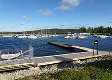 Ludvika port
 -
 S/S Wäsman in Ludvika port
 -
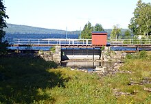 The dam between Ludvika ström and Väsman
 -
 Sunnansjö port


References
Citations
Sources
- Karlberg, Lars Anders (10 October 2011). "Järnskatten som SSAB missade". Ny Teknik. Retrieved 2013-10-15.
{{cite web}}: Invalid|ref=harv(help)