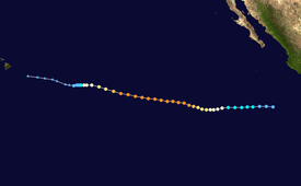
Hurricane Daniel (2006)
This article documents a current event. Information may change rapidly as the event progresses, and initial news reports may be unreliable. The latest updates to this article may not reflect the most current information. |
| |||
|---|---|---|---|
| |||
| As of: | 11 p.m. HST July 24 (0900 UTC July 25) | ||
| Location: | 16.2°N, 142.7°W | ||
| Sustained winds: | 65 mph (105 km/h) (1-min mean) | ||
| Pressure: | 999 mbar (29.50 inHg) | ||
| Movement: | W at 7 mph (15 km/h) | ||
| See more detailed information. | |||
Hurricane Daniel is the fifth tropical cyclone, fourth named storm, third hurricane, and second major hurricane of the 2006 Pacific hurricane season. It is also the first storm to affect the Central Pacific in 2006.
Storm history

Tropical storm (39–73 mph, 63–118 km/h)
Category 1 (74–95 mph, 119–153 km/h)
Category 2 (96–110 mph, 154–177 km/h)
Category 3 (111–129 mph, 178–208 km/h)
Category 4 (130–156 mph, 209–251 km/h)
Category 5 (≥157 mph, ≥252 km/h)
Unknown
On July 16, a tropical disturbance formed off the western Central Amrican coast and quickly increased in convective activity and organization. The NHC designated it as a tropical depression that night (July 17 UTC). The depression continued to organize and was designated as a tropical storm the next day. The storm continued to intensify and was declared a hurricane on July 18. Hurricane Daniel then went over rapid intensification and was upgraded to major hurricane status (Category Three or higher on the Saffir-Simpson Hurricane Scale) early on July 20 (UTC). It continued to intensify to a Category 4 hurricane and peaked as a very strong Category 4 hurricane on July 21 with maximum sustained winds of 150 mph and a minimum pressure of 933 mbars. Daniel was also noted as an annular hurricane by the NHC due to its clear, well-defined eye and circular symmetric pattern. But early on July 23 (UTC), Hurricane Daniel began to weaken over colder waters.
Current storm information

As of 5 p.m. HST July 24 (0300 UTC July 25), Hurricane Daniel was located near 16.1°N, 142.3°W It had maximum sustained winds of 75 mph (120 km/h), with higher gusts. The storm was moving toward the west at about 9 mph (15 km/h). The minimum central pressure was 994 mbar (29.35 inHg). The storm is now forecast to continue westward and gradually weaken over the next five days as wind shear increases and it moves over cooler waters. Daniel is forecast to affect Hawaii later this week.
External Links
- See the NHC's archive on Hurricane Daniel.
- See the Central Pacific Hurricane Center's latest public advisory on Hurricane Daniel.


