Santa María Chiquimula
Santa María Chiquimula | |
|---|---|
Municipality | |
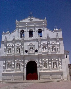
 Catholic church of Santa María Chiquimula | |
 Santa María Chiquimula within Totonicapán | |
 Totonicapán within Guatemala | |
| Coordinates: 15°01′45″N 91°19′46″W / 15.02917°N 91.32944°W | |
| Country | |
| Department | |
| Government | |
| • Type | Municipal |
| Area | |
| • Total | 236 km2 (91 sq mi) |
| Elevation | 2,130 m (6,990 ft) |
| Population (2018 census)[2] | |
| • Total | 55,013 |
| • Density | 230/km2 (600/sq mi) |
| • Ethnicities | K'iche' Ladino |
| • Religions | Catholicism Evangelicalism Maya |
| Climate | Cwb |
| Website | Official site |
Santa María Chiquimula is a town, with a population of 15,919 (2018 census),[3] and a municipality in the Totonicapán department of Guatemala. Located in the western highlands of Guatemala at an altitude of 2130 meters.[1] The municipality has a territory of 211 km2 and a population of around 48,525 people in 2012.[4] The Mayan K’iche’ language is spoken among the indigenous people here, but Spanish is also widely spoken. The main products of the region are corn and black beans.

References
- ^ a b "Santa María Chiquimula. Datos geográficos". Municipalidad de Santa María Chiquimula. Archived from the original on 2012-02-18. Retrieved 2012-02-28.
- ^ Citypopulation.de Population of Department and municipalities in Guatemala
- ^ [https://www.citypopulation.de/en/guatemala/cities/ Population of cities & towns in Guatemala
- ^ Cite error: The named reference
INEwas invoked but never defined (see the help page).
External links
 Media related to Santa María Chiquimula at Wikimedia Commons

