Achit Lake: Difference between revisions
Content deleted Content added
m r2.7.1) (robot Adding: it:Ačit Nuur |
add other related category per WP:CATDEFINING |
||
| (39 intermediate revisions by 28 users not shown) | |||
| Line 1: | Line 1: | ||
{{Short description|A lake in Uvs Province, Mongolia}} |
|||
{{Infobox lake |
{{Infobox lake |
||
| name = Achit Lake |
|||
| image =Achit-Nuur_Lake,_Mongolia,_Landsat-7,_2007-08-13.jpg |
|||
| |
| caption = Achit Lake satellite image ([[Landsat-7]], 2007-08-13) |
||
| alt = A satellite image of the lake |
|||
| image_bathymetry = |
|||
| image_bathymetry = |
|||
| caption_bathymetry = |
|||
| ⚫ | |||
|pushpin_map=Mongolia |
|||
| ⚫ | |||
| ⚫ | |||
| ⚫ | |||
| ⚫ | |||
| ⚫ | |||
| type = |
|||
| inflow = |
|||
| outflow = |
|||
| ⚫ | |||
| catchment = |
|||
| ⚫ | |||
| width = 16 km |
|||
| length = {{convert|28|km|abbr=on}} |
|||
| area = 290 km² |
|||
| width = {{convert|16|km|abbr=on}} |
|||
| depth = |
|||
| area = {{convert|290|km2|abbr=on}} |
|||
| max-depth = |
|||
| depth = |
|||
| max-depth = |
|||
| volume = |
|||
| residence_time = |
|||
| ⚫ | |||
| shore = |
|||
| ⚫ | |||
| cities = |
|||
| islands = |
|||
| ⚫ | |||
| embedded = {{Designation list |
|||
| ⚫ | |||
| designation1 = Ramsar |
|||
| designation1_offname = Lake Achit and its surrounding wetlands |
|||
| designation1_date = 22 March 2004 |
|||
| designation1_number = 1376<ref>{{Cite web|title=Lake Achit and its surrounding wetlands|website=[[Ramsar Convention|Ramsar]] Sites Information Service|url=https://rsis.ramsar.org/ris/1376|accessdate=25 April 2018}}</ref>}} |
|||
}} |
}} |
||
'''Achit |
'''Achit Lake''' ({{lang-mn|Ачит Нуур}}, {{MongolUnicode|ᠠᠴᠢᠲᠤ}}{{MongolUnicode|ᠨᠠᠭᠤᠷ}}, {{lang-zh|阿奇特湖}}) is the largest freshwater [[lake]] in [[Uvs Province|Uvs Aimag]] (Uvs province), [[Mongolia]], in the west of the country. At an elevation of 1,435 m above sea level it covers an area of 290 km<sup>2</sup>. It is 28 km long, 16 km wide, and 10 m deep. The coast is covered with [[steppe]]s, mostly hilly but [[swamp]]y on the northwest and northeast. Several rivers flow into the lake. |
||
==See also== |
|||
*[[Ramsar sites in Mongolia]] |
|||
==References== |
|||
{{Reflist}} |
|||
==External links== |
==External links== |
||
{{commons category}} |
|||
| ⚫ | |||
*[http://www.ramsar.org/cda/en/ramsar-pubs-notes-anno-mongolia/main/ramsar/1-30-168%5E16502_4000_0__ The Annotated Ramsar List: Mongolia] |
|||
| ⚫ | |||
*[http://www.geodata.es/mongolian_lakes Limnological Catalog of Mongolian Lakes] |
*[http://www.geodata.es/mongolian_lakes Limnological Catalog of Mongolian Lakes] |
||
{{Mongolia |
{{Lakes in Mongolia}} |
||
[[Category:Lakes of Mongolia]] |
[[Category:Lakes of Mongolia]] |
||
[[Category:Landforms of Uvs Province]] |
|||
[[Category:Ramsar sites in Mongolia]] |
|||
{{Mongolia-lake-stub}} |
|||
[[cs:Ačit núr]] |
|||
[[it:Ačit Nuur]] |
|||
[[lv:Ačitnūrs]] |
|||
[[lt:Ačit Nuras]] |
|||
[[ru:Ачит-Нуур]] |
|||
[[vi:Achit Nuur]] |
|||
Latest revision as of 02:29, 29 January 2024
| Achit Lake | |
|---|---|
 Achit Lake satellite image (Landsat-7, 2007-08-13) | |
| Location | Uvs Aimag |
| Coordinates | 49°30′N 90°30′E / 49.500°N 90.500°E |
| Basin countries | Mongolia |
| Max. length | 28 km (17 mi) |
| Max. width | 16 km (9.9 mi) |
| Surface area | 290 km2 (110 sq mi) |
| Surface elevation | 1,435 m (4,708 ft) |
| Official name | Lake Achit and its surrounding wetlands |
| Designated | 22 March 2004 |
| Reference no. | 1376[1] |
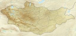
Achit Lake (Mongolian: Ачит Нуур, ᠠᠴᠢᠲᠤᠨᠠᠭᠤᠷ, Chinese: 阿奇特湖) is the largest freshwater lake in Uvs Aimag (Uvs province), Mongolia, in the west of the country. At an elevation of 1,435 m above sea level it covers an area of 290 km2. It is 28 km long, 16 km wide, and 10 m deep. The coast is covered with steppes, mostly hilly but swampy on the northwest and northeast. Several rivers flow into the lake.
See also[edit]
References[edit]
- ^ "Lake Achit and its surrounding wetlands". Ramsar Sites Information Service. Retrieved 25 April 2018.
External links[edit]
Wikimedia Commons has media related to Achit-Nuur lake.
- The Annotated Ramsar List: Mongolia
- Big Soviet Encyclopaedia – Russian (АЧИТ-НУР)
- Limnological Catalog of Mongolian Lakes

