Aegidienberg: Difference between revisions
Content deleted Content added
Commons |
Replacing geodata: {{coord|50|39|31|N|7|18|09|E|region:DE-NW_type:city|display=title}} |
||
| Line 8: | Line 8: | ||
{{Commons|Category:Bad Honnef-Aegidienberg|Aegidienberg}} |
{{Commons|Category:Bad Honnef-Aegidienberg|Aegidienberg}} |
||
{{ |
{{coord|50|39|31|N|7|18|09|E|region:DE-NW_type:city|display=title}} |
||
[[Category:Bad Honnef]] |
[[Category:Bad Honnef]] |
||
Revision as of 14:53, 20 September 2008

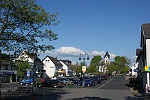
Aegidienberg is a German village situated southeast of Köln (Cologne). Since 1969 it has been administratively a part of the municipality of Bad Honnef on the river Rhine. The name comes from the Christian saint Aegidius (French: Giles).
Aegidienberg itself comprises thirteen individual villages: Aegidienberg, Brüngsberg, Efferoth, Himberg, Höhe, Hövel, Neichen, Orscheid, Retscheid, Rottbitze, Siefenhoven, Wintersberg and Wülscheid. As of 2002 the population was 6,673 and growing.
The Aegidienberger breed of horse, a type of Iceland pony, originated here. In November 1923 the last battle of the Rhine region's separatism was fought around the villages of the municipality.
Wikimedia Commons has media related to Aegidienberg.
