
Heidelberg, Victoria: Difference between revisions
→Facilities: corrected formal name of Austin hospital |
→History: some additional history info |
||
| Line 44: | Line 44: | ||
Heidelberg was proclaimed a City on 11 April 1934, but its rural space exceeded the urban area. The [[Heidelberg Town Hall]] was built in 1937. Subdivision and settlement clustered around Heidelberg Road and the Melbourne to Hurstbridge railway line which bisected the municipality in a generally north-east direction. Along that line are Darebin, Ivanhoe, Eaglemont, Heidelberg, Rosanna, Macleod, Watsonia and Greensborough. Mont Park was reached by a spur line from Macleod. Heidelberg West, unserved by railway, was sparsely settled until the 1950s when it was built on by the Housing Commission and provided the site for the athletes' village for the 1956 Melbourne Olympic Games. |
Heidelberg was proclaimed a City on 11 April 1934, but its rural space exceeded the urban area. The [[Heidelberg Town Hall]] was built in 1937. Subdivision and settlement clustered around Heidelberg Road and the Melbourne to Hurstbridge railway line which bisected the municipality in a generally north-east direction. Along that line are Darebin, Ivanhoe, Eaglemont, Heidelberg, Rosanna, Macleod, Watsonia and Greensborough. Mont Park was reached by a spur line from Macleod. Heidelberg West, unserved by railway, was sparsely settled until the 1950s when it was built on by the Housing Commission and provided the site for the athletes' village for the 1956 Melbourne Olympic Games. |
||
By the 1970s the residential development of the Heidelberg municipality was complete but for some areas in Viewbank and Lower |
By the 1970s the residential development of the Heidelberg municipality was complete but for some areas in Viewbank and Lower Plenty. The shopping areas were mostly of the typical strip kind, but an early (1956) free-standing centre was built in Heidelberg West, to a design by the Housing Commission which drew on American trends. |
||
The population of the Heidelberg municipality (before the severances in the 1960s) was 8,610 (1911), 34,401 (1947, excluding Greensborough), and 60,007 (1961). The population in 1991 was 60,468. On 15 December, 1994, most of Heidelberg City was united with part of Eltham Shire to form Banyule City. |
The population of the Heidelberg municipality (before the severances in the 1960s) was 8,610 (1911), 34,401 (1947, excluding Greensborough), and 60,007 (1961). The population in 1991 was 60,468. On 15 December, 1994, most of Heidelberg City was united with part of Eltham Shire to form Banyule City. |
||
In 1994, councils all over Victoria were amalgamated by the [[Jeff Kennett|Kennett]] [[Liberal Party of Australia|Liberal]] government. In that year, Heidelberg City Council merged with others in the area to become Banyule City Council. |
In 1994, councils all over Victoria were amalgamated by the [[Jeff Kennett|Kennett]] [[Liberal Party of Australia|Liberal]] government. In that year, Heidelberg City Council merged with others in the area to become Banyule City Council. |
||
Evidence of Heidelberg's long history and early settlement can be found throughout the municipality. The cemetry on Upper Heidelberg Rd contains some of the oldest graves in Victoria. An even older cemetry, the size of house block near the corner of St James Rd and Hawdon St, contains graves dating back before the establishment in 1851 of the Victorian State. The local primary school opened in 1854, a scant three years after that event. Banyule Homestead, which still stands today, was built in 1846 and the Old England Hotel first opened its doors in 1848. |
|||
==Facilities== |
==Facilities== |
||
Revision as of 18:25, 31 August 2007
| Heidelberg Melbourne, Victoria | |||||||||||||||
|---|---|---|---|---|---|---|---|---|---|---|---|---|---|---|---|
| Population | 4727 (2001 census) | ||||||||||||||
| • Density | Lua error: Unable to convert population "4727 (2001 census)" to a number. | ||||||||||||||
| Established | 1838 | ||||||||||||||
| Postcode(s) | 3084 | ||||||||||||||
| Area | 2.7 km2 (1.0 sq mi) | ||||||||||||||
| Location | 14 km (9 mi) from Melbourne | ||||||||||||||
| LGA(s) | City of Banyule | ||||||||||||||
| State electorate(s) | Ivanhoe | ||||||||||||||
| Federal division(s) | Jagajaga | ||||||||||||||
| |||||||||||||||
Heidelberg is a suburb (and former local government area) of Melbourne, Victoria, Australia. It lies 14 km north-east of central Melbourne.
Heidelberg lies next to the Yarra River, and its name is associated with the flowering of Australian art in the Heidelberg School. West Heidelberg was also the location of the athletes' village for the 1956 Summer Olympic Games.
History
Land at Heidelberg was sold by Crown auction in 1838, making it one of the earliest rural allotments. (Central Melbourne's first land sale was on 1 June, 1837). By 1840 there was a surveyed township named Warringal (Aboriginal for eagle's nest).
Warringal gave way to "Heidelberg", a name applied by a land agent derived for the German city of Heidelberg. There was a proposal by the Heidelberg City Council to change the name during WWII, but there was public outcry and the name stayed.
At the time of its settlement, Heidelberg was reached by a track from Melbourne via North Fitzroy, and in 1841 the Heidelberg Road Trust was formed. As a form of local government it preceded the Melbourne town council. By the late 1840s the road had a toll bar at the Merri Creek, and a macadamised surface. It became a tourist attraction, enhancing Heidelberg's reputation as a desirable place for views, excursions and rural estates. Cattle overlander Joseph Hawdon had built his Gothic Banyule homestead in 1846 overlooking the Yarra Valley. Heidelberg was proclaimed a shire on 27 January, 1871.
The appealing rural scenery had attracted artists in the 1880s, not least because the absence of public utilities and a railway (until 1888) caused houses to be vacated and available at low rents. The plein air school of painting from Box Hill rented a cottage at Eaglemont in 1888, culminating in the "Heidelberg School" of Australian art. Two years later the Chartersville homestead was occupied for similar purposes. The views from Mount Eagle and across the Yarra Valley were especially impressive.
Heidelberg was proclaimed a City on 11 April 1934, but its rural space exceeded the urban area. The Heidelberg Town Hall was built in 1937. Subdivision and settlement clustered around Heidelberg Road and the Melbourne to Hurstbridge railway line which bisected the municipality in a generally north-east direction. Along that line are Darebin, Ivanhoe, Eaglemont, Heidelberg, Rosanna, Macleod, Watsonia and Greensborough. Mont Park was reached by a spur line from Macleod. Heidelberg West, unserved by railway, was sparsely settled until the 1950s when it was built on by the Housing Commission and provided the site for the athletes' village for the 1956 Melbourne Olympic Games.
By the 1970s the residential development of the Heidelberg municipality was complete but for some areas in Viewbank and Lower Plenty. The shopping areas were mostly of the typical strip kind, but an early (1956) free-standing centre was built in Heidelberg West, to a design by the Housing Commission which drew on American trends.
The population of the Heidelberg municipality (before the severances in the 1960s) was 8,610 (1911), 34,401 (1947, excluding Greensborough), and 60,007 (1961). The population in 1991 was 60,468. On 15 December, 1994, most of Heidelberg City was united with part of Eltham Shire to form Banyule City.
In 1994, councils all over Victoria were amalgamated by the Kennett Liberal government. In that year, Heidelberg City Council merged with others in the area to become Banyule City Council.
Evidence of Heidelberg's long history and early settlement can be found throughout the municipality. The cemetry on Upper Heidelberg Rd contains some of the oldest graves in Victoria. An even older cemetry, the size of house block near the corner of St James Rd and Hawdon St, contains graves dating back before the establishment in 1851 of the Victorian State. The local primary school opened in 1854, a scant three years after that event. Banyule Homestead, which still stands today, was built in 1846 and the Old England Hotel first opened its doors in 1848.
Facilities
The Austin and Repatriation Medical Centre is based in Heidelberg. The Austin hospital has undergone extensive renovations recently, and now also contains the Mercy Hospital for Women. These two facilities combined measure up to be largest hospital in Victoria.
Heidelberg train station lies on the border of zone 1 and 2 within the Melbourne train system. It is located north of the Eaglemont railway station, a famous site for its native garden. The Eaglemont village is also distinguished for the well-preserved 1920s buildings.
The Heidelberg Shopping Centre, known as "Burgundy Street" has recently been revived. It had become rundown in the 1980s, but a new supermarket, and many trendy cafes have made the area much more liveable; as a result, house prices have increased dramatically.
Banyule is a small locality in Heidelberg near the river bordering Rosanna. It is named after the Woiwurrung word Banyule, meaning "hill".
Gallery
-
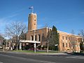 Heidelberg Town Hall
 -
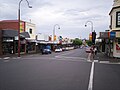 Burgundy St. Shopping District
 -
 Burgundy Street with Austin Hospital visible on hill
 -
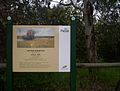 Artists Trail sign at Heidelberg
 -
Residence, typical of the area's style
-
Triple front units, typical of the area's style
-
An Edwardian styled house
-
A Spanish Mission styled house


Template:Mapit-AUS-suburbscale
External links
- ^ Heidelberg, accessed 5 March 2007