Grafarvogur: Difference between revisions
m remove Erik9bot category,outdated, tag and general fixes |
m fix Icelandic IPA |
||
| (48 intermediate revisions by 30 users not shown) | |||
| Line 1: | Line 1: | ||
{{Infobox settlement |
|||
{{Unreferenced stub|auto=yes|date=December 2009}} |
|||
| name = Grafarvogur |
|||
{{Reykjavík}} |
|||
| native_name = <!-- If different from English name --> |
|||
'''Grafarvogur''' is one of the largest residential [[suburb]]s of [[Reykjavík]], [[Iceland]]. It is a relatively new neighbourhood, major construction began in the late 1980s and continued well into the 90's. Now it has established itself as a "good" family-friendly neighbourhood. The average income of its inhabitants are above the national average and services are exceptionally accessible. It is one of the best planned neighbourhoods in Reykjavík and was meant to be rich and beautiful from the beginning. |
|||
| settlement_type = District |
|||
| image_skyline = Grafarvogs (3).JPG |
|||
| image_alt = |
|||
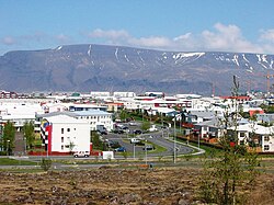
| image_caption = View towards Rimahverfi |
|||
| image_map = Reykjavík map (D08-Grafarvogur).png |
|||
| map_caption = |
|||
| subdivision_type = Country |
|||
| subdivision_name = [[Iceland]] |
|||
| subdivision_type1 = Municipality |
|||
| subdivision_name1 = [[Reykjavík]] |
|||
| unit_pref = Metric |
|||
| area_water_percent = |
|||
| area_total_km2 = 14 |
|||
| area_land_km2 = |
|||
| area_water_km2 = |
|||
| area_urban_km2 = 7.7 |
|||
| area_rural_km2 = |
|||
| area_total_ha = |
|||
| elevation_m = |
|||
| population_total = 18,000 |
|||
| population_as_of = 2010 |
|||
| population_density_km2 = auto |
|||
| population_note = |
|||
| postal_code_type = Postal code |
|||
| postal_code = IS-112 |
|||
| website = |
|||
| footnotes = |
|||
}} |
|||
'''Grafarvogur''' ({{IPA-is|ˈkraːvarˌvɔːɣʏr̥}}) is among the largest residential [[district]]s of [[Reykjavík]], [[Iceland]]. It is a relatively new neighbourhood, major construction began in the late 1980s and continued well into the 1990s.<ref>{{Cite web|url=https://hiticeland.com/iceland/grafarvogur|title=Grafarvogur is a district in Reykjavík the capital of Iceland|website=Hit Iceland|language=en|access-date=2018-09-02}}</ref><ref>{{Cite news|url=http://icelandmag.is/article/reykjaviks-first-campervan-site-opens-grafarvogur|title=Reykjavík's first campervan site opens in Grafarvogur|work=Icelandmag|access-date=2018-09-02|language=en}}</ref> |
|||
== |
==Neighbourhoods== |
||
The district includes 14 neighbourhoods: Hamrar {{IPA-is|ˈhamrar̥|}}, Foldir {{IPA-is|ˈfɔltɪr̥|}}, Hús {{IPA-is|ˈhuːs|}}, Rimar {{IPA-is|ˈrɪːmar̥|}}, Borgir {{IPA-is|ˈpɔrcɪr̥|}}, Víkur {{IPA-is|ˈviːkʏr̥|}}, Engi {{IPA-is|ˈeiɲcɪ|}}, Spöng {{IPA-is|ˈspœyŋk|}}, Staðir {{IPA-is|ˈstaːðɪr̥|}}, Höfðar {{IPA-is|ˈhœvðar̥|}}, Bryggjuhverfi {{IPA-is|ˈprɪccʏˌkʰvɛrvɪ|}}, Geirsnef {{IPA-is|ˈceir̥sˌnɛːf|}}, Gufunes {{IPA-is|ˈkʏːvʏˌnɛːs|}}, and Geldinganes {{IPA-is|ˈcɛltiŋkaˌnɛːs|}}. Of those, five (Rimar, Hamrar, Borgir, Víkur and Foldir) fall within the boundaries of historic [[Gufunes]] estate.<ref>{{Cite news|url=https://grapevine.is/mag/articles/2012/01/06/grafarvogur-history-reykjavik/|title=Grafarvogur Has A Hidden History And Some Treasure To Boot! - The Reykjavik Grapevine|last=grapevine.is|date=2012-01-06|work=The Reykjavik Grapevine|access-date=2018-09-02|language=en-US}}</ref> |
|||
[[File:Grafarvogs (3).JPG|thumb|200px|left|Panorama of Grafarvogur: subdistricts of Rimi and Borgir]] |
|||
Today Grafarvogur comprises eight sub-districts of which five - the Rimi, Hamrar, Borgir, Víkur and western Fold subdistricts - fall within the boundaries of historic Gufunes estate. |
|||
==Shopping== |
==Shopping== |
||
Grafarvogur currently has one medium-sized shopping centre called Spöngin. It's not a mall in itself but a cluster of stores, [[Hagkaup]] being the largest. Also there are small clusters of stores in Hverafold, by Víkurvegur and Langirimi Streets. Those are much smaller and |
Grafarvogur currently has one medium-sized shopping centre called Spöngin. It's not a mall in itself but a cluster of stores, [[Hagkaup]] being the largest. Also, there are small clusters of stores in Hverafold, by Víkurvegur and Langirimi Streets. Those are much smaller and contain only a few stores, the supermarkets being the largest of the few. |
||
==References== |
|||
| ⚫ | |||
{{reflist}} |
|||
[[File:Grafarvogur1.jpg|thumb|left|250px|Grafarvogur, the district and the name giving bay]] |
|||
== |
==External links== |
||
* [http://grafarvogsbuar.is/ Official website] |
|||
Grafarvogur is one of the larger suburbs of [[Reykjavík]] with a population of over 20,000. |
|||
* [https://reykjavik.is/skrifstofaogsvid/grafarvogur Government website] |
|||
{{Commons category|Grafarvogur}} |
{{Commons category-inline|Grafarvogur}} |
||
{{Districts of Reykjavik City}} |
|||
| ⚫ | |||
[[Category:Settlements in Iceland]] |
|||
[[Category:Districts of Reykjavík]] |
[[Category:Districts of Reykjavík]] |
||
{{Iceland-geo-stub}} |
{{Iceland-geo-stub}} |
||
[[is:Grafarvogur]] |
|||
[[uk:Ґраварвоґур]] |
|||
Latest revision as of 05:18, 30 September 2023
Grafarvogur | |
|---|---|
District | |
 View towards Rimahverfi | |
 | |
| Country | Iceland |
| Municipality | Reykjavík |
| Area | |
| • District | 14 km2 (5 sq mi) |
| • Urban | 7.7 km2 (3.0 sq mi) |
| Population (2010) | |
| • District | 18,000 |
| • Density | 1,300/km2 (3,300/sq mi) |
| Postal code | IS-112 |
Grafarvogur (Icelandic pronunciation: [ˈkraːvarˌvɔːɣʏr̥]) is among the largest residential districts of Reykjavík, Iceland. It is a relatively new neighbourhood, major construction began in the late 1980s and continued well into the 1990s.[1][2]
Neighbourhoods[edit]
The district includes 14 neighbourhoods: Hamrar [ˈhamrar̥], Foldir [ˈfɔltɪr̥], Hús [ˈhuːs], Rimar [ˈrɪːmar̥], Borgir [ˈpɔrcɪr̥], Víkur [ˈviːkʏr̥], Engi [ˈeiɲcɪ], Spöng [ˈspœyŋk], Staðir [ˈstaːðɪr̥], Höfðar [ˈhœvðar̥], Bryggjuhverfi [ˈprɪccʏˌkʰvɛrvɪ], Geirsnef [ˈceir̥sˌnɛːf], Gufunes [ˈkʏːvʏˌnɛːs], and Geldinganes [ˈcɛltiŋkaˌnɛːs]. Of those, five (Rimar, Hamrar, Borgir, Víkur and Foldir) fall within the boundaries of historic Gufunes estate.[3]
Shopping[edit]
Grafarvogur currently has one medium-sized shopping centre called Spöngin. It's not a mall in itself but a cluster of stores, Hagkaup being the largest. Also, there are small clusters of stores in Hverafold, by Víkurvegur and Langirimi Streets. Those are much smaller and contain only a few stores, the supermarkets being the largest of the few.
References[edit]
- ^ "Grafarvogur is a district in Reykjavík the capital of Iceland". Hit Iceland. Retrieved 2018-09-02.
- ^ "Reykjavík's first campervan site opens in Grafarvogur". Icelandmag. Retrieved 2018-09-02.
- ^ grapevine.is (2012-01-06). "Grafarvogur Has A Hidden History And Some Treasure To Boot! - The Reykjavik Grapevine". The Reykjavik Grapevine. Retrieved 2018-09-02.

External links[edit]
![]() Media related to Grafarvogur at Wikimedia Commons
Media related to Grafarvogur at Wikimedia Commons
