
Gsür
| Gsür | |
|---|---|
.jpg) | |
| Highest point | |
| Elevation | 2,708 m (8,885 ft) |
| Prominence | 372 m (1,220 ft)[1] |
| Parent peak | Albristhorn |
| Listing | Alpine mountains 2500-2999 m |
| Coordinates | 46°30′38.8″N 07°31′11.4″E / 46.510778°N 7.519833°E |
| Geography | |
 Gsür Location in Switzerland | |
| Location | Bern, Switzerland |
| Parent range | Bernese Alps |
The Gsür is a mountain in the Bernese Alps at the very southeastern end of the Diemtigtal and rising above Adelboden in the Entschligetal in the canton of canton of Bern.
Impressions[edit]
-
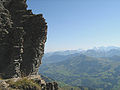 View during the ascent

References[edit]
External links[edit]
This article about a mountain, mountain range, or peak located in the canton of Bern is a stub. You can help Wikipedia by expanding it. |