Ip, Sălaj: Difference between revisions
Content deleted Content added
m robot Adding: vo:Ip |
add pic to infobox |
||
| (39 intermediate revisions by 26 users not shown) | |||
| Line 1: | Line 1: | ||
{{Infobox Romanian subdivision |
|||
{{Infobox Settlement <!--more fields are available for this Infobox--See Template:Infobox Settlement--> |
|||
|type = commune |
|||
|subdivision_type = [[Countries of the world|Country]] |
|||
| |
|county = Sălaj |
||
|name = Ip |
|||
|timezone=[[Eastern European Time|EET]] |
|||
|other_name = Ipp |
|||
|utc_offset=+2 |
|||
|image_flag = |
|||
|timezone_DST=[[Eastern European Summer Time|EEST]] |
|||
| ⚫ | |||
|utc_offset_DST=+3 |
|||
|image_skyline = Szilágyippi ref templom.jpg |
|||
| ⚫ | |||
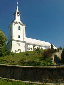
|image_caption = Reformed church in Ip |
|||
|image_location = |
|||
| |
|||
|image_map = Ip jud Salaj.png |
|||
official_name=Comuna Ip<br/>Ipp község| |
|||
| ⚫ | |||
image_map=| |
|||
|leader_name = László Márkus<ref>{{cite web |url=https://prezenta.roaep.ro/locale27092020/romania-pv-final |title=Results of the 2020 local elections |publisher=Central Electoral Bureau |access-date=11 June 2021 |df=dmy-all}}</ref> |
|||
| ⚫ | |||
|leader_party = UDMR |
|||
|subdivision_type1=[[Counties of Romania|County]]| |
|||
|term = 2020–2024 |
|||
subdivision_name1=Sălaj County| |
|||
|coordinates = {{coord|47|13|45|N|22|36|22|E|display=it}} |
|||
|subdivision_type2=[[Subdivisions of Romania|Status]]| |
|||
|elevation = 190 |
|||
subdivision_name2=[[Communes of Romania|Commune]] |
|||
|elevation_min = |
|||
|settlement_type=Commune|| |
|||
|elevation_max = |
|||
|leader_title=[[Mayor]]| |
|||
|area_total = 59.89 |
|||
leader_name=N/A| |
|||
|area_footnotes = |
|||
area_total_km2=60.13| |
|||
population_as_of= |
|population_as_of = |
||
population_total= |
|population_total = auto |
||
|population_footnotes = |
|||
website=http://www.cjsj.ro/localitati/ip.html#english| |
|||
|postal_code = 457210 |
|||
|area_code = (+40) 02 60 |
|||
|website = {{URL|https://primariaip.ro/}} |
|||
}} |
}} |
||
'''Ip |
'''Ip''' ({{lang-ro|Ip}}; {{lang-hu|Ipp}}) is a commune in [[Sălaj County]], [[Crișana]], [[Romania]]. It is composed of five villages: Cosniciu de Jos (''Alsókaznacs''), Cosniciu de Sus (''Felsőkaznacs''), Ip, Zăuan (''Szilágyzovány''), and Zăuan-Băi (''Zoványfürdő''). |
||
The commune was the initial site of the events that led to the [[Ip massacre]] in 1940. |
|||
==Population== |
|||
* 1981 [[Hungarian people|Hungarians]] (50.2%) |
|||
* 1466 [[Romanians]] (37.15%) |
|||
* 383 [[Roma people|Roma]] (9.7%) |
|||
* 111 [[Slovaks]] (2.81%) |
|||
* 5 (other) (0.14%) |
|||
== Sights == |
|||
| ⚫ | |||
* Reformed Church in Ip, built in the 16th century, [[monument istoric|historic monument]]<ref>[http://www.momumenteromania.ro/index.php/monumente/search/5780 monumenteromania.ro - Reformed Church in Ip, historic monument]{{dead link|date=December 2017 |bot=InternetArchiveBot |fix-attempted=yes }}, retrieved on May 18, 2012</ref> |
|||
==References== |
|||
| ⚫ | |||
{{Reflist}} |
|||
{{Sălaj County}} |
|||
[[it:Ip (Sălaj)]] |
|||
{{DEFAULTSORT:Ip, Salaj}} |
|||
[[hu:Ipp]] |
|||
[[ |
[[Category:Communes in Sălaj County]] |
||
| ⚫ | |||
[[vo:Ip]] |
|||
| ⚫ | |||
Latest revision as of 12:30, 2 April 2024
Ip
Ipp | |
|---|---|
 Reformed church in Ip | |
 Location in Sălaj County | |
| Coordinates: 47°13′45″N 22°36′22″E / 47.22917°N 22.60611°E | |
| Country | Romania |
| County | Sălaj |
| Government | |
| • Mayor (2020–2024) | László Márkus[1] (UDMR) |
| Area | 59.89 km2 (23.12 sq mi) |
| Elevation | 190 m (620 ft) |
| Population (2021-12-01)[2] | 3,288 |
| • Density | 55/km2 (140/sq mi) |
| Time zone | EET/EEST (UTC+2/+3) |
| Postal code | 457210 |
| Area code | (+40) 02 60 |
| Vehicle reg. | SJ |
| Website | primariaip |
Ip (Romanian: Ip; Hungarian: Ipp) is a commune in Sălaj County, Crișana, Romania. It is composed of five villages: Cosniciu de Jos (Alsókaznacs), Cosniciu de Sus (Felsőkaznacs), Ip, Zăuan (Szilágyzovány), and Zăuan-Băi (Zoványfürdő).
The commune was the initial site of the events that led to the Ip massacre in 1940.
Sights[edit]
- Reformed Church in Ip, built in the 16th century, historic monument[3]
References[edit]
- ^ "Results of the 2020 local elections". Central Electoral Bureau. Retrieved 11 June 2021.
- ^ "Populaţia rezidentă după grupa de vârstă, pe județe și municipii, orașe, comune, la 1 decembrie 2021" (XLS). National Institute of Statistics.
- ^ monumenteromania.ro - Reformed Church in Ip, historic monument[permanent dead link], retrieved on May 18, 2012


