User talk:Fr33kman/Mainspace and Weddell Sea: Difference between pages
m start talk page, please feel free to comment on and critique ''(ie: whinge about)'' my edits! :-) |
m removed dublicated category |
||
| Line 1: | Line 1: | ||
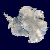
[[Image:Antarctica_6400px_from_Blue_Marble.jpg|thumb|200px|right|An aerial view of [[Antarctica]]. Weddell Sea is the 'bay' in the top left corner.]] |
|||
{{talkheader}} |
|||
The '''Weddell Sea''' is part of the [[Southern Ocean]]. Its land boundaries are defined by the bay formed from the coasts of [[Coats Land]] and the [[Antarctic Peninsula]]. Much of the southern part of the sea, up to [[Elephant Island]], is permanent ice, the [[Filchner-Ronne Ice Shelf]]. The sea is contained within the two overlapping [[Antarctic]] territorial claims of [[Argentina]], ([[Argentine Antarctica]]) and [[UK|Britain]] ([[British Antarctic Territory]]), and also resides partially within the territorial claim of [[Chile]] ([[Antártica Chilena Province|Antarctic Chilean Territory]]). At its widest the sea is around 2,000 km across, in area it is around 2.8 million km². |
|||
The sea is named after the British sailor [[James Weddell]] who entered the sea in 1823 as far as 74° S. It was first widely explored by the [[Scotland|Scot]] [[William S. Bruce]] over 1902-04. |
|||
__TOC__ |
|||
It was in this sea that [[Ernest Shackleton|Shackleton's]] ship, the [[Endurance (1912 ship)|''Endurance'']] was trapped and crushed by ice in 1915. |
|||
==Comments== |
|||
The ice shelves which used to extend roughly 3900 square miles (10,000 km²) over the Weddell Sea have completely disappeared by 2002. |
|||
It is believed that the break-up of [[Gondwana]] started in the Weddell Sea. |
|||
==See also== |
|||
*[[Weddell Seal]] |
|||
{{coord|75|02|58|S|47|15|46|W|region:AQ_type:waterbody|display=title}} |
|||
[[Category:British Antarctic Territory]] |
|||
[[Category:Geography of Magallanes and Chilean Antártica Region]] |
|||
[[Category:Seas of the Southern Ocean]] |
|||
[[Category:Argentine Antarctica]] |
|||
[[Category:Magallanes y Antártica Chilena Region]] |
|||
{{WAntarctica-geo-stub}} |
|||
{{ocean-stub}} |
|||
[[bg:Море Уедъл]] |
|||
[[ca:Mar de Weddell]] |
|||
[[cs:Weddellovo moře]] |
|||
[[de:Weddell-Meer]] |
|||
[[eo:Maro de Weddell]] |
|||
[[et:Weddelli meri]] |
|||
[[es:Mar de Weddell]] |
|||
[[eo:Maro de Weddell]] |
|||
[[eu:Weddell itsasoa]] |
|||
[[fr:Mer de Weddell]] |
|||
[[gl:Mar de Weddell]] |
|||
[[ko:웨들 해]] |
|||
[[it:Mare di Weddell]] |
|||
[[lv:Vedela jūra]] |
|||
[[lt:Vedelio jūra]] |
|||
[[nl:Weddellzee]] |
|||
[[ja:ウェッデル海]] |
|||
[[no:Weddellhavet]] |
|||
[[pl:Morze Weddella]] |
|||
[[pt:Mar de Weddell]] |
|||
[[ru:Море Уэдделла]] |
|||
[[sk:Weddellovo more]] |
|||
[[sr:Веделово море]] |
|||
[[fi:Weddellinmeri]] |
|||
[[sv:Weddellhavet]] |
|||
[[tr:Weddell Denizi]] |
|||
[[uk:Море Веделла]] |
|||
[[zh:威德尔海]] |
|||
Revision as of 09:54, 11 October 2008

The Weddell Sea is part of the Southern Ocean. Its land boundaries are defined by the bay formed from the coasts of Coats Land and the Antarctic Peninsula. Much of the southern part of the sea, up to Elephant Island, is permanent ice, the Filchner-Ronne Ice Shelf. The sea is contained within the two overlapping Antarctic territorial claims of Argentina, (Argentine Antarctica) and Britain (British Antarctic Territory), and also resides partially within the territorial claim of Chile (Antarctic Chilean Territory). At its widest the sea is around 2,000 km across, in area it is around 2.8 million km².
The sea is named after the British sailor James Weddell who entered the sea in 1823 as far as 74° S. It was first widely explored by the Scot William S. Bruce over 1902-04.
It was in this sea that Shackleton's ship, the Endurance was trapped and crushed by ice in 1915.
The ice shelves which used to extend roughly 3900 square miles (10,000 km²) over the Weddell Sea have completely disappeared by 2002.
It is believed that the break-up of Gondwana started in the Weddell Sea.
