Tebesbest: Difference between revisions
Content deleted Content added
Ptbotgourou (talk | contribs) m r2.7.2) (Robot: Adding ar:تبسبست |
Estopedist1 (talk | contribs) m Removing from Category:Algeria using Cat-a-lot |
||
| (19 intermediate revisions by 12 users not shown) | |||
| Line 1: | Line 1: | ||
{{Infobox settlement |
{{Infobox settlement |
||
|official_name =Tebesbest |
| official_name = Tebesbest |
||
|other_name = |
| other_name = |
||
|native_name |
| native_name = ﺗﻴﺒسﺴﺖ |
||
|nickname = |
| nickname = |
||
|settlement_type =Commune and town |
| settlement_type = Commune and town |
||
|motto = |
| motto = |
||
|image_skyline = |
| image_skyline = |
||
|imagesize = |
| imagesize = |
||
|image_caption = |
| image_caption = |
||
|image_flag = |
| image_flag = |
||
|flag_size = |
| flag_size = |
||
|image_seal = |
| image_seal = |
||
|seal_size = |
| seal_size = |
||
|image_map = |
| image_map = File:DZ 30 Tebesbest.svg |
||
|mapsize = |
| mapsize = |
||
|map_caption = |
| map_caption = |
||
|pushpin_map = |
| pushpin_map = Algeria |
||
|pushpin_label_position =bottom |
| pushpin_label_position = bottom |
||
|pushpin_mapsize=300 |
| pushpin_mapsize = 300 |
||
|pushpin_map_caption = |
| pushpin_map_caption = |
||
|subdivision_type = Country |
| subdivision_type = Country |
||
|subdivision_name ={{flag|Algeria}} |
| subdivision_name = {{flag|Algeria}} |
||
|subdivision_type1 = [[Provinces of Algeria|Province]] |
| subdivision_type1 = [[Provinces of Algeria|Province]] |
||
|subdivision_name1 =[[ |
| subdivision_name1 = [[Touggourt Province]] |
||
|subdivision_type2 = [[Districts of Algeria|District]] |
| subdivision_type2 = [[Districts of Algeria|District]] |
||
|subdivision_name2 = |
| subdivision_name2 = [[Touggourt District]] |
||
|subdivision_type3 = |
| subdivision_type3 = |
||
|subdivision_name3 = |
| subdivision_name3 = |
||
|government_footnotes = |
| government_footnotes = |
||
|government_type = |
| government_type = |
||
|leader_title = |
| leader_title = |
||
|leader_name = |
| leader_name = |
||
|established_title = |
| established_title = Established<ref name="OfficialWebsite"/> |
||
|established_date = |
| established_date = 1984 |
||
|area_magnitude = |
| area_magnitude = |
||
|unit_pref = |
| unit_pref = Metric |
||
|area_footnotes = |
| area_footnotes = <ref name="OfficialWebsite"/> |
||
|area_total_km2 = |
| area_total_km2 = 26 |
||
|area_land_km2 = |
| area_land_km2 = |
||
|population_as_of = |
| population_as_of = 2008 |
||
|population_footnotes = |
| population_footnotes = <ref name="census2008"/> |
||
|population_note = |
| population_note = |
||
|population_total = |
| population_total = 35,032 |
||
|population_density_km2 = |
| population_density_km2 = auto |
||
|timezone = [[Central European Time|CET]] |
| timezone = [[Central European Time|CET]] |
||
|utc_offset |
| utc_offset = +1 |
||
| coordinates = {{coord|33|7|N|6|5|E|display=inline}} |
|||
|latd=|latm= |lats= |latNS=N |
|||
| elevation_footnotes = <ref name="OfficialWebsite"/> |
|||
|longd=|longm=|longs=|longEW=E |
|||
| ⚫ | |||
|elevation_footnotes = |
|||
| |
| elevation_ft = |
||
| |
| postal_code_type = |
||
| |
| postal_code = |
||
| |
| area_code = |
||
| |
| blank_name = |
||
| |
| blank_info = |
||
| |
| website = |
||
| |
| footnotes = |
||
| ⚫ | |||
}} |
}} |
||
'''Tebesbest''' is a town and [[Communes of Algeria|commune]] in [[Ouargla Province]], [[Algeria]]. According to the 1998 census it has a population of 29,840.<ref>[http://www.statoids.com/ydz.html Statoids]</ref> |
|||
'''Tebesbest''' is a town and [[Communes of Algeria|commune]] in [[Touggourt District]], [[Touggourt Province]], [[Algeria]], and forms a part of the urban area of [[Touggourt]]. According to the 2008 census it has a population of 35,032,<ref name="census2008">{{cite web|title=Population: Ouargla Wilaya|url=http://www.ons.dz/collections/w30_p1.pdf|publisher=Office National des Statistiques Algérie|accessdate=24 February 2013|language=French}}</ref> up from 29,840 in 1998,<ref>{{cite web|title=Algeria Communes|url=http://www.statoids.com/ydz.html|publisher=Statoids|accessdate=8 March 2013}}</ref> and a population growth rate of 1.7%.<ref name="census2008"/> It is a predominantly agricultural community, with [[Date (fruit)|dates]] being the main product.<ref name="OfficialWebsite">{{cite web|title=Official website of the province of Ouargla - Tebesbest|url=http://wilaya-ouargla.dz/ar/index.php/2012-11-14-16-35-54/2012-11-14-16-35-64/2012-11-14-16-35-70|accessdate=26 February 2013|language=Arabic}}</ref> |
|||
==Localities== |
|||
The commune is composed of seven localities:<ref>{{cite web|title=Décret n° 84-365, fixant la composition, la consistance et les limites territoriale des communes. Wilaya d'El Oued|url=http://www.joradp.dz/JO8499/1984/067/FP1551.pdf|publisher=Journal officiel de la République Algérienne|accessdate=2 March 2013|archiveurl=https://web.archive.org/web/20130302112245/http://www.joradp.dz/JO8499/1984/067/FP1551.pdf |archivedate=2 March 2013 |page=1551|language=French|date=19 December 1984}}</ref> |
|||
{{div col}} |
|||
*Quartier de Tebesbest |
|||
*Lebdouat |
|||
*Beni Assoued |
|||
*Ayad |
|||
*Z.H.U.N. |
|||
*El Bahdja I |
|||
*El Bahdja II |
|||
{{div col end}} |
|||
==References== |
==References== |
||
{{ |
{{Portal|Algeria}} |
||
{{Reflist}} |
|||
{{-}} |
|||
<div align="center">'''Neighbouring towns and cities'''</div> |
|||
{{Geographic location |
|||
|Centre = Tebesbest |
|||
|North = '''[[Biskra]]'''<br/>[[Sidi Slimane, Ouargla|Sidi Slimane]]<br>[[Megarine]] |
|||
|Northeast = |
|||
|East = [[Taibet]]<br/>'''[[El Oued]]''' |
|||
|Southeast = ''[[Grand Erg Oriental]]'' |
|||
|South = '''[[Touggourt]]'''<br/>[[Hassi Messaoud]] |
|||
|Southwest = '''[[Ouargla]]''' |
|||
|West = [[Zaouia El Abidia]] |
|||
|Northwest = |
|||
}} |
|||
| ⚫ | |||
{{Ouargla Province}} |
{{Ouargla Province}} |
||
{{coord|33|07|N|6|05|E|display=title|region:DZ_type:city_source:GNS-enwiki}} |
{{coord|33|07|N|6|05|E|display=title|region:DZ_type:city_source:GNS-enwiki}} |
||
[[Category: |
[[Category:Communes of Ouargla Province]] |
||
[[Category: |
[[Category:Cities in Algeria]] |
||
| ⚫ | |||
[[ar:تبسبست]] |
|||
[[fr:Tebesbest]] |
|||
[[ro:Tebesbest]] |
|||
[[vi:Tebesbest]] |
|||
Latest revision as of 19:26, 22 July 2023
Tebesbest
ﺗﻴﺒسﺴﺖ | |
|---|---|
Commune and town | |
 | |
| Coordinates: 33°7′N 6°5′E / 33.117°N 6.083°E | |
| Country | |
| Province | Touggourt Province |
| District | Touggourt District |
| Established[1] | 1984 |
| Area | |
| • Total | 26 km2 (10 sq mi) |
| Elevation | 85 m (279 ft) |
| Population (2008)[2] | |
| • Total | 35,032 |
| • Density | 1,300/km2 (3,500/sq mi) |
| Time zone | UTC+1 (CET) |
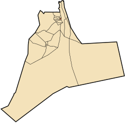
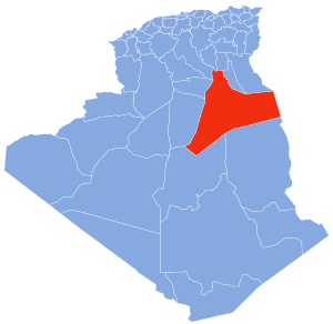
Tebesbest is a town and commune in Touggourt District, Touggourt Province, Algeria, and forms a part of the urban area of Touggourt. According to the 2008 census it has a population of 35,032,[2] up from 29,840 in 1998,[3] and a population growth rate of 1.7%.[2] It is a predominantly agricultural community, with dates being the main product.[1]
Localities[edit]
The commune is composed of seven localities:[4]
- Quartier de Tebesbest
- Lebdouat
- Beni Assoued
- Ayad
- Z.H.U.N.
- El Bahdja I
- El Bahdja II
References[edit]
- ^ a b c d "Official website of the province of Ouargla - Tebesbest" (in Arabic). Retrieved 26 February 2013.
- ^ a b c "Population: Ouargla Wilaya" (PDF) (in French). Office National des Statistiques Algérie. Retrieved 24 February 2013.
- ^ "Algeria Communes". Statoids. Retrieved 8 March 2013.
- ^ "Décret n° 84-365, fixant la composition, la consistance et les limites territoriale des communes. Wilaya d'El Oued" (PDF) (in French). Journal officiel de la République Algérienne. 19 December 1984. p. 1551. Archived from the original (PDF) on 2 March 2013. Retrieved 2 March 2013.
Neighbouring towns and cities


